It looks like you're using an Ad Blocker.
Please white-list or disable AboveTopSecret.com in your ad-blocking tool.
Thank you.
Some features of ATS will be disabled while you continue to use an ad-blocker.

Prove or disprove a Pentagon fly-over.
page: 10share:
reply to post by LaBTop
LaBTop....there is no such thing as a "washington central tower". It is an animal that simply doesn't exist.
Here is a flight, from take-off to landing:
Depending on the airport, there may be a "Ramp Control" This is usually staffed by the airline, and is co-ordinated with...."Ground Control"
Ground Control is an ATC function....there are specific frequencies dedicated to 'ground'....please use your aviaiton band scanner to listen in. Frequencies are usually 121.9....could be 121. 7 or 121.6 or 121.8....depends on how close other airports are....crosstalk interference is the reason for different freqs.
OK....Ground Control hands off an airplane to "local"....which is know as the Tower frequency. "Local" is the responsibility of the roughly five mile radus....of course, depending on the airport, will vary. But, essentially, 'local', the 'TOWER'...gives clearaces to take-off, and clearances to land.
Moving on....after take-off, we are 'handed off' to 'departure'....what is also known as TRACON. TRACON have, in the USA, certain responsiblities, in airspace....each 'sector' has a responsible controller at the post. In order to 'hand off' an airplane, a controller must, via telephone, or some sort of communication method, be able to relay that, in fact....the airplane they are responsible for is being "HANDED OFF" to another's responsiblity....and, so it goes....
As airplanes climb, they are repeatedly 'handed off'....to other sectors, each sector being the responsibility of a controller.
Arriving, for landing....the process is reversed.
I am not sure how to explain it any simpler!!!
Sure.....Hollywood makes it look stupid....they use terms that pilots laugh at....but, real pilots know how the ATC system works.....
Ehh, Weed, do you also have a comment on the strange 45 seconds discrepancy between the "officially translated" textual tape recordings, and my own
measure of time stamps in that same tape?
And you could duplicate that by listening yourself to that TYSON tape.
And you could duplicate that by listening yourself to that TYSON tape.
I'll react on Reheat's post on page 7 :
www.abovetopsecret.com...
Well, first of all, I always like to compare data, even if the fault margin is different.
In this case, I have reasons to believe the radar data could have been tampered with, especially since you think we have no radar returns after the moment the plane passed the Sheraton Hotel.
I'm quite certain that there were more radar screen read-outs from all surrounding airfields in use that day, military and public ones.
Like Andrews, Dulles, Baltimore, Linden, Washington Central, Reagan International, etc.
Thus it was not only the DCA radar which covered flight 77's path to the Pentagon.
I find the fault margin involved quite reasonable, since we have such precise time stamps for certain events which we can pinpoint to a map of that area. And a long time period to use in the calculations.
In this case, the longer the time period, the smaller the fault margin for calculated average air speeds.
However, I need to correct my assumed 10 miles flight path to a now 27.44 miles long stretch covered by flight 77 from the moment Dulles Approach advised TYSON of a fast moving primary target currently 10 miles west of DCA. After checking my own reasoning it has become clear to me that on a 10 miles radius from DCA radar disk on the north tip of Reagan Airport grounds, there is only one point where that radius will cross flight 77's official flight path, namely just left of exits 7 and 8 on Route 495 and Route 60's crossing.
On a side note, it is increasingly difficult for a pilot in an accelerating to full speed and meanwhile banking plane, to hit a fixed point, like a wall.
That's probably why the official, south of Citgo flight path used a straight, level line to impact, instead of the now clearly different described north of Citgo flight path, with quite a right bank in it.
A right banking plane could never have clipped all 5 light poles at the same heights. Poles on the right would have been clipped much lower than on the left of the plane's fuselage, so the staged 5 light poles indicated a staged leveled out flight path, while all REAL witnesses did not describe that at all, they all described a right bank.
This right bank does give credulity to a whole other scenario than the straight level one from the government.
We know from many witnesses now, that the plane banked to the right, and a few others told us it banked and accelerated with full throttle. Planes tend to drift away in such instances.
The more difficult it becomes to hit a wall with it, because of drift.
Thus, let's have a closer look again at this officially endorsed flight path from Flight 77, with the huge circling around, before reaching the Pentagon.
You can use this one to enter your own estimates, if you feel that need.
672 x 575 Pixels (Width x Height) :
www.alsx.info...
It's obvious, that we have a near straight line to impact, from Route 236 to Route 7's crossing with Columbia Pike which is named also as Route 244 (the crossing's name is Bailey's Crossroads), to the Navy Annex where the plane passed over, then made a slight right bank until reaching the Pentagon's west wall.
I measured via Google Earth Maps the distance from the DCA radar to exit 167 on Route 95 being 10 miles.
That's the second exit south of the Route 495 and 95 crossing (under that 495 sign, on above map).
The distance from the plane when crossing Route 236, up to the west wall of the Pentagon, I measured on that map being 6.5 miles. Of course the plane was on a descent, thus the stretch may be a bit longer in reality. But for the time being, I only want to establish the average airspeeds involved.
If you want, you can deduce the angle of descend from the known altitudes perhaps available online.
But as O'Brien noted, the plane was still descending and northeast bound, flying low when it crossed in front of his C-130.
Here you have the same above map with the official flight path of flight 77, now superimposed with the possible GOFER06 = C-130 flight paths, the 10 and 5 miles distances imprinted and some of the TYSON audio tape time stamps added. I don't know if a military plane could perform such tight turns as I show, but the turns and final departure northwest-wards of the C-130 are not really important for the calculations.
It's the first straight stretch after crossing the Potomac River of the C-130 which is crucial.
That's where the observations which matter, are told by its pilot O'Brien, in the TYSON audio tape.
And those observations leave only a few positions for the C-130 on the above official map with the official flight 77 flight path on it, for the official time stamps positions of the C-130, available from the TYSON tape.
OfficialFlight77FlightpathReleased11aug06BIG+C130
895 x 766 Pixels (Width x Height):
www.alsx.info...

(I have numbered all timestamps on the above official map in red.)
1. 09:33:45 Dulles Approach advised TYSON of a fast moving primary target currently 10 miles west of DCA, which is the Reagan Tower radar disk position just to the right of runway 19's begin.
-snip-
2. 09:36:16 GOFER06 issued traffic (2a), eleven o'clock (a bit left of him), 5 miles(from DCA Reagan Airport) northbound, fast moving, type and altitude unknown.
(Since he can't identify its make and altitude yet, O'Brien must be quite a distance away, and the plane was definitely not at one of my drawn in, 5 miles arc away from DCA, possible positions, because the only possibility would have been a view to O'Brien's three o'clock position (my red 8) at this moment.)
3. 09:36:22 GOFER06 advises traffic in sight (3a or 3a' ) at twelve o'clock. (In front of him)
(This moment is only 6 seconds later, and between now and the following 7 seconds O'Brien was able to identify the plane as a B757, so he had a good look during his twelve o'clock to his four o'clock view.)
4. 09:36:29 GOFER06 advised it looked like a B757.
5. 09:36:51 GOFER06 states the traffic is still in a descent and rolling out northeast bound (at low altitude).
(That's 22 seconds later... Could he really look around at his five to six o'clock view? He probably asked his co-pilot in the right seat. That co-pilot could look to the right and back that far to report it to O'Brien.)
6. 09:38:00 GOFER06 advised aircraft was down just northwest of DCA (Reagan Airport).
That's 255 seconds to cover the whole circle from point 1 back to point 7 again and then to the Pentagon west wall, and that total distance is 27.44 miles.
An average speed of 0.1076 miles/sec or (x 3600 secs) is 387.36 miles/hour.
That certainly will keep that plane airborne.
The stretch flown by the plane from (1) to (7) and all the way back to (7) again is 24 miles, measured by placing a metal wire over that flight path om my screen, and then measuring the wire.
Then compared it to the 10 and 5 mile distances laid out on that screen map.
And the rest of the flight path from (7) to the Pentagon's west wall is 3.44 miles.
A total length of 27.44 miles.
To fully understand the added time stamps in the last drawing, this is my page 6 post about times based on the DCA and TYSON tower FAA operator tapes from the Farmer web site www.abovetopsecret.com...
And in there, are the important quotes about the released textual timeline from the officially FOIA released Washington Tower TYSON/FLUKY Position, abbreviated as TYSON, audio tape regarding officially endorsed communications between radar operators, Secret Service personnel and FAA flight operators.
I repeat that I made a very important mis-estimation, the total flight path from the "10 miles to DCA" report to the west wall is FAR further than I thought.
It included the whole circling around !
When you draw a circle 10 miles wide around the DCA radar disk on Reagan Airport, then the only time that line crosses the depicted yellow line of the official Flight 77 path, is just behind the crossing of Routes 495 and 60, my red number 1 on the map.
www.abovetopsecret.com...
LaBTop, might I suggest that you use radar data to calculate a speed. You do know it's available, don't you?
Trying to calculate an aircraft's speed based on radio calls is akin to trying to measure the speed of light with an abacus!
You really and truly need to find some other hobby.
Well, first of all, I always like to compare data, even if the fault margin is different.
In this case, I have reasons to believe the radar data could have been tampered with, especially since you think we have no radar returns after the moment the plane passed the Sheraton Hotel.
I'm quite certain that there were more radar screen read-outs from all surrounding airfields in use that day, military and public ones.
Like Andrews, Dulles, Baltimore, Linden, Washington Central, Reagan International, etc.
Thus it was not only the DCA radar which covered flight 77's path to the Pentagon.
I find the fault margin involved quite reasonable, since we have such precise time stamps for certain events which we can pinpoint to a map of that area. And a long time period to use in the calculations.
In this case, the longer the time period, the smaller the fault margin for calculated average air speeds.
However, I need to correct my assumed 10 miles flight path to a now 27.44 miles long stretch covered by flight 77 from the moment Dulles Approach advised TYSON of a fast moving primary target currently 10 miles west of DCA. After checking my own reasoning it has become clear to me that on a 10 miles radius from DCA radar disk on the north tip of Reagan Airport grounds, there is only one point where that radius will cross flight 77's official flight path, namely just left of exits 7 and 8 on Route 495 and Route 60's crossing.
On a side note, it is increasingly difficult for a pilot in an accelerating to full speed and meanwhile banking plane, to hit a fixed point, like a wall.
That's probably why the official, south of Citgo flight path used a straight, level line to impact, instead of the now clearly different described north of Citgo flight path, with quite a right bank in it.
A right banking plane could never have clipped all 5 light poles at the same heights. Poles on the right would have been clipped much lower than on the left of the plane's fuselage, so the staged 5 light poles indicated a staged leveled out flight path, while all REAL witnesses did not describe that at all, they all described a right bank.
This right bank does give credulity to a whole other scenario than the straight level one from the government.
We know from many witnesses now, that the plane banked to the right, and a few others told us it banked and accelerated with full throttle. Planes tend to drift away in such instances.
The more difficult it becomes to hit a wall with it, because of drift.
Thus, let's have a closer look again at this officially endorsed flight path from Flight 77, with the huge circling around, before reaching the Pentagon.
You can use this one to enter your own estimates, if you feel that need.
672 x 575 Pixels (Width x Height) :
www.alsx.info...

It's obvious, that we have a near straight line to impact, from Route 236 to Route 7's crossing with Columbia Pike which is named also as Route 244 (the crossing's name is Bailey's Crossroads), to the Navy Annex where the plane passed over, then made a slight right bank until reaching the Pentagon's west wall.
I measured via Google Earth Maps the distance from the DCA radar to exit 167 on Route 95 being 10 miles.
That's the second exit south of the Route 495 and 95 crossing (under that 495 sign, on above map).
The distance from the plane when crossing Route 236, up to the west wall of the Pentagon, I measured on that map being 6.5 miles. Of course the plane was on a descent, thus the stretch may be a bit longer in reality. But for the time being, I only want to establish the average airspeeds involved.
If you want, you can deduce the angle of descend from the known altitudes perhaps available online.
But as O'Brien noted, the plane was still descending and northeast bound, flying low when it crossed in front of his C-130.
Here you have the same above map with the official flight path of flight 77, now superimposed with the possible GOFER06 = C-130 flight paths, the 10 and 5 miles distances imprinted and some of the TYSON audio tape time stamps added. I don't know if a military plane could perform such tight turns as I show, but the turns and final departure northwest-wards of the C-130 are not really important for the calculations.
It's the first straight stretch after crossing the Potomac River of the C-130 which is crucial.
That's where the observations which matter, are told by its pilot O'Brien, in the TYSON audio tape.
And those observations leave only a few positions for the C-130 on the above official map with the official flight 77 flight path on it, for the official time stamps positions of the C-130, available from the TYSON tape.
OfficialFlight77FlightpathReleased11aug06BIG+C130
895 x 766 Pixels (Width x Height):
www.alsx.info...
(I have numbered all timestamps on the above official map in red.)
1. 09:33:45 Dulles Approach advised TYSON of a fast moving primary target currently 10 miles west of DCA, which is the Reagan Tower radar disk position just to the right of runway 19's begin.
-snip-
2. 09:36:16 GOFER06 issued traffic (2a), eleven o'clock (a bit left of him), 5 miles(from DCA Reagan Airport) northbound, fast moving, type and altitude unknown.
(Since he can't identify its make and altitude yet, O'Brien must be quite a distance away, and the plane was definitely not at one of my drawn in, 5 miles arc away from DCA, possible positions, because the only possibility would have been a view to O'Brien's three o'clock position (my red 8) at this moment.)
3. 09:36:22 GOFER06 advises traffic in sight (3a or 3a' ) at twelve o'clock. (In front of him)
(This moment is only 6 seconds later, and between now and the following 7 seconds O'Brien was able to identify the plane as a B757, so he had a good look during his twelve o'clock to his four o'clock view.)
4. 09:36:29 GOFER06 advised it looked like a B757.
5. 09:36:51 GOFER06 states the traffic is still in a descent and rolling out northeast bound (at low altitude).
(That's 22 seconds later... Could he really look around at his five to six o'clock view? He probably asked his co-pilot in the right seat. That co-pilot could look to the right and back that far to report it to O'Brien.)
6. 09:38:00 GOFER06 advised aircraft was down just northwest of DCA (Reagan Airport).
That's 255 seconds to cover the whole circle from point 1 back to point 7 again and then to the Pentagon west wall, and that total distance is 27.44 miles.
An average speed of 0.1076 miles/sec or (x 3600 secs) is 387.36 miles/hour.
That certainly will keep that plane airborne.
The stretch flown by the plane from (1) to (7) and all the way back to (7) again is 24 miles, measured by placing a metal wire over that flight path om my screen, and then measuring the wire.
Then compared it to the 10 and 5 mile distances laid out on that screen map.
And the rest of the flight path from (7) to the Pentagon's west wall is 3.44 miles.
A total length of 27.44 miles.
To fully understand the added time stamps in the last drawing, this is my page 6 post about times based on the DCA and TYSON tower FAA operator tapes from the Farmer web site www.abovetopsecret.com...
And in there, are the important quotes about the released textual timeline from the officially FOIA released Washington Tower TYSON/FLUKY Position, abbreviated as TYSON, audio tape regarding officially endorsed communications between radar operators, Secret Service personnel and FAA flight operators.
I repeat that I made a very important mis-estimation, the total flight path from the "10 miles to DCA" report to the west wall is FAR further than I thought.
It included the whole circling around !
When you draw a circle 10 miles wide around the DCA radar disk on Reagan Airport, then the only time that line crosses the depicted yellow line of the official Flight 77 path, is just behind the crossing of Routes 495 and 60, my red number 1 on the map.
reply to post by LaBTop
NO.....but I will try to listen, Just on the, off chance....IF you are rweferring to the ATC tape, that was provided by Boone......remember, we only hear what was recorded....NOT anything said off tape...
NO.....but I will try to listen, Just on the, off chance....IF you are rweferring to the ATC tape, that was provided by Boone......remember, we only hear what was recorded....NOT anything said off tape...
TYSON audio tape female voice introductory lasts 14 seconds, and this is the original, FOIA-freed official tape from John Farmer's website, where
Boone also got it from :
www.aal77.com...
and at 12:14 in the tape, which starts at 09:25:00 EST you can HEAR O'Brien saying the "757" remark.
That's an official 757 remark time of 09:37:14 EST.
And this is the textual, TYSON tape partial transcript :
aal77.com...
where you can READ the same official "757" remark, but now at 09:36:29 EST.
That's 45 seconds difference and thus earlier, for the same event!
But on the actual tape you hear that it took place in fact 45 seconds LATER !
Did you also notice the new discovered other transcripts from the same events?
And how they did cut out the time stamps at the end. To mask the real time?
Weedwhacker, I also would like to know how many seconds would be needed for a B757 to build up speed a.k.a. accelerate from 387.36 miles/hour to 535 miles/hour, when the pilot would suddenly push full throttle.
Since we have many different descriptions by witnesses WHEN the pilot pushed to full throttle.
We even have witnesses who did not hear the plane at all, it "glided in".
Can that be found online, or do we need technical instruction books from the plane's manufacturer?
And of course we have to take in account the difference of air resistance at ground level and at 10,000 meters cruising speed. I doubt the manufacturer will provide stats for such speeds at ground level.
They will not advocate to fly that low with that speed anyhow.
[edit on 1/6/09 by LaBTop]
reply to post by LaBTop
Speed can build up pretty fast, in a descent. Actually, there are many variables here.
EVEN with throttles at Flight Idle, a Jet will accelerate going "downhill"...every jet pilot knows this....we are descending to comply with a 'crossing restriction', for instance (A max altitude at a specific point....an intersection, a VOR or other waypoint). As I said, even at idle, speed will build quickly...push the nose lower, increase rate of descent, but speed increases. We have speed brakes, of course....they provide added drag...actually, in descent, they are not really that effective, since they don't all activate, when in "AIR" mode....so, speed brakes are used on flight, and are most effective to slow, not really to increase descent rate, though they do help with that. Also, of course, the other feature of the spoilers is during the landing sequence....they are then referred to as Ground Spoilers, as all panels extend, to destroy lift (Assuming all hydraulic systems are operating normally, of course).
Sorry, I ran on a bit there...is difficult to explain all aspects of flying, in a forum such as this.
Suffice to say, given a suicidal maniac at the controls, then indeed the airplane will accellerate quickly. As to eyewitness accounts....recall that laypeople say what they think, and aren't using terminology that is exact --- and the witnesses that claim to have not heard the jet....recall also the extreme difference in the speed of light and the speed of sound. We see an event, and depending on the distance, we hear it differently. (Think of a fireworks display, for instance).
reply to post by LaBTop
LaBTop, that AAL77.com website appears to have been taken down and most of those links look to be broken. See my post here for more information:
www.abovetopsecret.com...
I believe that ATS member Boone 870 mentioned having some of those files on that thread.
LaBTop, that AAL77.com website appears to have been taken down and most of those links look to be broken. See my post here for more information:
www.abovetopsecret.com...
I believe that ATS member Boone 870 mentioned having some of those files on that thread.
This is a post from SPreston :
www.abovetopsecret.com...
in my “”FAA or 84RADES data falsified, or both”” thread, at page 2.
That was the picture with RADES radar data and RADES time stamps in it, I was searching for :
[atsimg]http://files.abovetopsecret.com/images/member/7904ae38c716.jpg[/atsimg]
When you observe all the blue and yellow time stamp intervals, it directly becomes clear that a constant time interval of about 12 seconds is shown.
That must be the sweep time for one full 360° circle made by the DCA VOR (the radar disc in position on the north-eastern tip of Reagan International Airport).
As can be easily seen, the blue pin at 9:36:01 is the position of the pilot of the C-130 when he reported to the tower that he saw “the 757” at his 12 o’clock position, which is the yellow pin, time-stamped also as 9:36:01.
Now we know the position of the 757 and the time it was there. And we know its position and time when it was last seen by the last sweep of the DCA radar disk, namely at the Sheraton Hotel south wall as Reheat told us several times, and that time was 09:37:xx or 09:38:xx ???
The officially published impact time is 09:38:xx ???
The problem I have with these RADES radar data figures, they don’t match the timestamps from the FAA or Andrews AFB audio tapes:
1 DCA 108 TYSON 1325-1348-1
www.aal77.com...
This is an audio tape of 24 minutes and 26 seconds actual total duration.
The time which should have been covered in that tape and explained in the 14 seconds monologue by a female voice at the start of the tape needs to be 13:48 minus 13:25, which is 23 minutes and zero seconds. Those are the starting and ending time stamps described in the file name and by the FAA themselves.
A discrepancy of 1 minute and 26 seconds short of those 24:26 actual minutes and seconds.
In other words, 86 seconds extra time have been seemingly inserted or added.
A huge difference in actual time covered on that tape.
Which words could have been added, or what time interval at what position has been added?
And this is the textual transcript of the TYSON tape as given to us following a "Pinnacle" (his screen name) FOIA:
aal77.com...
The "Pinnacle" FOIA audio transcript document gives a time stamp for the visual 12 o'clock position of the 757, as seen by the approaching C-130, as being 09:36:22.
That’s not 09:36:01 as the RADES radar data give us.
And not 09:37:05 as we can calculate by listening ourselves to the same audio tape.
Start of tape is 09:25:00, and the voice of O’Brien telling us he observes the 757 at his 12 o’clock position starts talking at the 12:05 position in the tape. That’s actual local time 09:37:05.
Thus we have for the same event, in these FOIA freed documents and audio, three different time stamps:
O'Brien sees the 757 right in front of his cockpit:
1. Radar officially released:------09:36:01
2. Audio officially released:------09:36:22 (21 secs later)
3. Audio check in person:--------09:37:05 (43 secs later than 2., and even 64 secs later as 1.)
If no sane explanation can be obtained for these huge differences for the same event, we can conclude that all these FOIA freed data has to be taken with a huge grain of salt, and in case of no explanation, they are then proved malicious and false.
This is another radar data on a map drawing from JPreston’s above mentioned post:
[atsimg]http://files.abovetopsecret.com/images/member/227343fb4a40.jpg[/atsimg]
and in fact, if compared to the 4 ANC (Arlington National Cemetery) witness statements about the incoming and leaving directions of the C-130, I feel more committed to the following explanatory drawing :
[atsimg]http://files.abovetopsecret.com/images/member/d0644214208f.jpg[/atsimg]
reply to post by LaBTop
My, my my, so you've found the "smoking gun". Why don't you first publish the information on about 10 "truther" sites persuade a prosecutor to initiate legal action against all those "in on it" and then come back here with the links and I'll explain why you don't know what you're doing......
My, my my, so you've found the "smoking gun". Why don't you first publish the information on about 10 "truther" sites persuade a prosecutor to initiate legal action against all those "in on it" and then come back here with the links and I'll explain why you don't know what you're doing......
Please read my latests post:
www.abovetopsecret.com...
in the "FAA or 84RADES data falsified, or both" thread.
Those 26 seconds discrepancy found by that PfT poster, and the same 26 seconds discrepancy found by John Farmer shortly after he received those FOIA files from the FAA about the RADES radar data are also interesting, but do not fit in the above "lost" audio seconds.
reply to post by LaBTop
This comment, alone, shows that you are not very familiar with actual terminology, but just 'spouting' what rubbish you have gleaned from other sources.
I would like to reveal the actual location of the "Potomac" TRACON....but, I am not privy to it....and, it should not be public info, in any case.
MANY RADAR antennae are operating....to cover certain areas. Coverage varies, based on location of the antennae. Obstructions, topology, etc.
SO.....the composite data, in some form, are eventually funneled to Herndon, VA....where the central "Command Center" is currently located, for all FAA ATC functions.
BTW, next time you are frustrated by an airline, because of ground delays....don't blame the Airline!!! It is these people (I almost wrote 'bozos') who make the decisions to impose "Ground Stops" on flights due to depart....THEY impose the EDCTs (Expect Departure Clearance Time) on airline flights....making them stay at the gate.
In defense of the "Command Center" in Herndon....they do have live feeds of weather, from satellites and other sources. THEY can see how the weather will affect arrival and departure corridors. THEY do get calls from the facilities that handle the air traffic...imploring them, sometimes, to issue the "ground stops"....
BUT, as in any system, there are flaws....and usually, it is the Human factor!!! Hate to say it, but there it is. I had occasion to actually call the Herndon facility....because I was frustrated at my delay from KORD to KEWR. I was surprised to be put through to a real, live person. It helped.
Gov't bureaucracy exists....just have to break through, now and then.
...last sweep of the DCA radar disk,...
This comment, alone, shows that you are not very familiar with actual terminology, but just 'spouting' what rubbish you have gleaned from other sources.
I would like to reveal the actual location of the "Potomac" TRACON....but, I am not privy to it....and, it should not be public info, in any case.
MANY RADAR antennae are operating....to cover certain areas. Coverage varies, based on location of the antennae. Obstructions, topology, etc.
SO.....the composite data, in some form, are eventually funneled to Herndon, VA....where the central "Command Center" is currently located, for all FAA ATC functions.
BTW, next time you are frustrated by an airline, because of ground delays....don't blame the Airline!!! It is these people (I almost wrote 'bozos') who make the decisions to impose "Ground Stops" on flights due to depart....THEY impose the EDCTs (Expect Departure Clearance Time) on airline flights....making them stay at the gate.
In defense of the "Command Center" in Herndon....they do have live feeds of weather, from satellites and other sources. THEY can see how the weather will affect arrival and departure corridors. THEY do get calls from the facilities that handle the air traffic...imploring them, sometimes, to issue the "ground stops"....
BUT, as in any system, there are flaws....and usually, it is the Human factor!!! Hate to say it, but there it is. I had occasion to actually call the Herndon facility....because I was frustrated at my delay from KORD to KEWR. I was surprised to be put through to a real, live person. It helped.
Gov't bureaucracy exists....just have to break through, now and then.
The DCA VOR radar disk or whatever one prefers to call it, can be found at:
Latitude : 38°51’34.05”N
Longitude : 77° 2’11.21”W
You will find the 2009 image of it in Google Earth, however, you can use the historical imagery function to return to pictures of it around 9/11/2001.
Full : www.alsx.info...
Reheat, try for once to be helpful, instead of baiting others and being dis-respectful to about anyone here.
I expected you to remind me of the differences in reaction times from audio recordings by the recorded persons, instead of your usual answers. Try to react mature, forget the bullying, and we will treat you with respect too. Now you are just the bully around the block who seems to have protection from the headmaster here.
[edit on 20/6/09 by LaBTop]
Latitude : 38°51’34.05”N
Longitude : 77° 2’11.21”W
You will find the 2009 image of it in Google Earth, however, you can use the historical imagery function to return to pictures of it around 9/11/2001.

Full : www.alsx.info...
Reheat, try for once to be helpful, instead of baiting others and being dis-respectful to about anyone here.
I expected you to remind me of the differences in reaction times from audio recordings by the recorded persons, instead of your usual answers. Try to react mature, forget the bullying, and we will treat you with respect too. Now you are just the bully around the block who seems to have protection from the headmaster here.
[edit on 20/6/09 by LaBTop]
reply to post by LaBTop
LaBTop:
That phrase is gibberish. Any pilot can tell you it's a picture of the VOR. Radar and VOR have nothing in common!!!
VOR is an acronym for "VHF Omni-directional Range" It is a navigation device. Even student pilots know this...they learn how to use them early on, especially as they learn about cross-country flying...
They are also used as primary navigational references for certain Instrument Approaches, although GPS is becoming more dominant:
flightaware.com...
But, you don't have to take my word for it:
en.wikipedia.org...
Here is a side-view photo of the VOR of the type you Google Earthed:
en.wikipedia.org...-VOR_PEK.JPG
(Well...that didn't work so well. Guess the ATS BB code confuses it, makes a smiley. The pic is in the article referenced above. Or, look for it under File-VOR_PEK.JPG )
Other VOR designs will sometimes have the 'bowling pin' looking part in the center. Antenna for greater range, and to house the TACAN.
Here is what a typical ATC antenna looks like. Hint: They rotate!!
en.wikipedia.org...:ASR-9_Radar_Antenna.jpg
(Arrggh! Must be operator error... File:ASR-9_Radar_Antenna.jpg)
See if those work.
[edit on 6/20/0909 by weedwhacker]
LaBTop:
The DCA VOR radar disk or whatever one prefers to call it, can be found at:
That phrase is gibberish. Any pilot can tell you it's a picture of the VOR. Radar and VOR have nothing in common!!!
VOR is an acronym for "VHF Omni-directional Range" It is a navigation device. Even student pilots know this...they learn how to use them early on, especially as they learn about cross-country flying...
They are also used as primary navigational references for certain Instrument Approaches, although GPS is becoming more dominant:
flightaware.com...
But, you don't have to take my word for it:
en.wikipedia.org...
...In many cases the VOR stations have co-located DME (Distance Measuring Equipment) or military TACAN (TACtical Air Navigation -- the latter includes both the distance feature, DME, and a separate TACAN azimuth feature that provides military pilots data similar to the civilian VOR). A co-located VOR and TACAN beacon is called a VORTAC. A VOR with co-located DME only is called a VOR-DME. A VOR radial with DME distance allows a one-station position fix. Both VOR-DMEs and TACANs share the same DME system.
VORTACs and VOR-DMEs use a standardized scheme of VOR frequency - TACAN channel pairing so that a specific VOR frequency is always paired with a specific channel for the co-located TACAN or DME feature; on civilian equipment, the VHF frequency is tuned and the appropriate TACAN channel is automatically selected...
Here is a side-view photo of the VOR of the type you Google Earthed:
en.wikipedia.org...-VOR_PEK.JPG
(Well...that didn't work so well. Guess the ATS BB code confuses it, makes a smiley. The pic is in the article referenced above. Or, look for it under File-VOR_PEK.JPG )
Other VOR designs will sometimes have the 'bowling pin' looking part in the center. Antenna for greater range, and to house the TACAN.
Here is what a typical ATC antenna looks like. Hint: They rotate!!
en.wikipedia.org...:ASR-9_Radar_Antenna.jpg
(Arrggh! Must be operator error... File:ASR-9_Radar_Antenna.jpg)
See if those work.
[edit on 6/20/0909 by weedwhacker]
Originally posted by LaBTop
Reheat, try for once to be helpful, instead of baiting others and being dis-respectful to about anyone here.
Be respectful you say!!!!
You started a thread accusing many innocent people of complicity in mass murder simply because you accept the fraudulent crap that you don 't understand perpetuated by a cult and you have the audacity to ask me to be respectful?
There is nothing at all wrong about any Government related data that has been released that is not already well known. None of it has been manipulated.
I've suggested several times that you stop this nonsense and find another hobby because you have NO CLUE about what you're doing.
I have shown that and so has weedhacker.
There was no Pentagon flyover in that all valid data points to the fact that AA 77, an American Airlines 757 impacted the Pentagon and in the process took hundreds of innocent lives.
Now, you be respectful and stop the nonsense.
[edit on 20-6-2009 by Reheat]
Weed, that was a very helpful post, so, a VOR is a radio beacon.
I found it already quite weird that a supposed radar disk would “look” straight up.
Consequently, my picture above of the DCA VOR should be re-read as “DCA VOR radio beacon REAGAN National Airport.
This a VOR’s side view on another airport you linked to :
The DME function is explained here:
en.wikipedia.org...
“”Distance measuring equipment (DME) is a transponder-based radio navigation technology that measures distance by timing the propagation delay of VHF or UHF radio signals.””
And a rotating, fluctuating or nodding radar disk, the antenna system of an Airport Surveillance Radar-9 looks like this :
The actual position of the REAGAN National Airport rotating, fluctuating or nodding radar disk is thus not on the north tip of the airport, but on the south tip, to the right of runway 1 :
and this is a close-up of it, on top of its small tower :
This last few posts conversation is about distance measurement capabilities, which I do not contest.
Based on them, the FAA flight controller heard from his colleague that an unidentified plane was 10 miles from DCA.
Based on that, I measured some raw distances on an officially released flight 77 flight map.
Fine.
Can we now return to the measured OFFICIAL time discrepancies noted by me, and a productive counter to it, if one feels that my assumptions are not correct?
And it should be noted, that the C-130 pilot, O’Brien, gave his position to flight 77 in an ongoing conversation with the FAA flight controller, with no silence parts in it.
So, he reacted immediately when asked where the plane was “now”.
Thus we may assume that there were no more than 1 or 2 seconds delay to push his send knob.
And not 64 seconds difference between what we hear on the audio tape from the FAA-O’Brien conversation, and the RADES radar data.
I repeat once more:
The Pinnacle FOIA audio transcript document gives a timestamp for the visual 12’oclock position of the 757, as seen by the approaching C-130, as 09:36:22.
That’s not 09:36:01 as the RADES radar data give us.
And not 09:37:05 as we can calculate by listening ourselves to the same audio tape.
Start of tape is 09:25:00, and the voice of O’Brien telling us he observes the 757 at his 12 o’clock position starts talking at the 12:05 position in the tape. That’s actual local time 09:37:05.
Thus we have for the same event, in these FOIA freed documents and audio, three different time stamps:
1. Radar officially released 09:36:01
2. Audio officially released 09:36:22 (21 secs later)
3. Audio check in person 09:37:05 (43 secs later than 2., and even 64 secs later as 1.)
If no sane explanation can be obtained for these huge differences for the same event, we can conclude that all these FOIA freed data has to be taken with a huge grain of salt, and in case of no explanation, they are then proven malicious and false.
I found it already quite weird that a supposed radar disk would “look” straight up.
Consequently, my picture above of the DCA VOR should be re-read as “DCA VOR radio beacon REAGAN National Airport.
This a VOR’s side view on another airport you linked to :

The DME function is explained here:
en.wikipedia.org...
“”Distance measuring equipment (DME) is a transponder-based radio navigation technology that measures distance by timing the propagation delay of VHF or UHF radio signals.””
And a rotating, fluctuating or nodding radar disk, the antenna system of an Airport Surveillance Radar-9 looks like this :

The actual position of the REAGAN National Airport rotating, fluctuating or nodding radar disk is thus not on the north tip of the airport, but on the south tip, to the right of runway 1 :

and this is a close-up of it, on top of its small tower :

This last few posts conversation is about distance measurement capabilities, which I do not contest.
Based on them, the FAA flight controller heard from his colleague that an unidentified plane was 10 miles from DCA.
Based on that, I measured some raw distances on an officially released flight 77 flight map.
Fine.
Can we now return to the measured OFFICIAL time discrepancies noted by me, and a productive counter to it, if one feels that my assumptions are not correct?
And it should be noted, that the C-130 pilot, O’Brien, gave his position to flight 77 in an ongoing conversation with the FAA flight controller, with no silence parts in it.
So, he reacted immediately when asked where the plane was “now”.
Thus we may assume that there were no more than 1 or 2 seconds delay to push his send knob.
And not 64 seconds difference between what we hear on the audio tape from the FAA-O’Brien conversation, and the RADES radar data.
I repeat once more:
The Pinnacle FOIA audio transcript document gives a timestamp for the visual 12’oclock position of the 757, as seen by the approaching C-130, as 09:36:22.
That’s not 09:36:01 as the RADES radar data give us.
And not 09:37:05 as we can calculate by listening ourselves to the same audio tape.
Start of tape is 09:25:00, and the voice of O’Brien telling us he observes the 757 at his 12 o’clock position starts talking at the 12:05 position in the tape. That’s actual local time 09:37:05.
Thus we have for the same event, in these FOIA freed documents and audio, three different time stamps:
1. Radar officially released 09:36:01
2. Audio officially released 09:36:22 (21 secs later)
3. Audio check in person 09:37:05 (43 secs later than 2., and even 64 secs later as 1.)
If no sane explanation can be obtained for these huge differences for the same event, we can conclude that all these FOIA freed data has to be taken with a huge grain of salt, and in case of no explanation, they are then proven malicious and false.
reply to post by LaBTop
I told you I'd get back to you on this.
So, I've listened and analyzed.
Now, pay attention: WORD31 Heavy was 'issued maintain 3000' according to the Pinnacle transcript. This occurred at 13:27:06 UTC.
On the audio tape (108 TYSON) that transmission from ADW occurs 2:47 into the tape. Therefore the 'TYSON' tape actually began, including the intro, at time reference 13:24:19
Carrying on: WORD31 Heavy is cleared to 4000 on the tape, 3:37 after it starts. Added to 13:24:19 and you get 13:27:56 In the transcript it is 13:27:57 -- hardly a huge error!! Further, WORD31 Heavy is cleared to 15000 at 5:46 on the tape. Add it, and you get 13:30:05, compared to the Pinnacle time of 13:30:07
Again, not a big deal -- usually subject to the interpretation of whoever is transcribing the info.
At 12:00 into the tape, GOFER06 is issued the unknown traffic. This corresponds to 13:24:19 + 12:00 = 13:36:19 Pinnacle has it at 13:36:16
Now, the meat: At 13:38:26 Pinnacle has GOFER06 saying the aircraft crashed into the Pentagon. Calculated by listening to the tape it is at 13:38:30
You can hear it in GOFER06 pilot's voice, as he clears his throat. He is trying to remain professional, on the radio.
SO, I just don't understand your problem with the tape and 'transcript'. (It's not a real transcript, per se, more like a recap of pertinent events).
EDIT:
OIC! You think that because the female voice introduces the tape as occurring between 1325 and 1348 UTC you think she means exactly 1325 as a start time??!!?? Listen up, again. She says it "...concerns communication at the TYSON position during 1325 to 1348 UTC..."
Making any sense now?
Another EDIT:
From an earlier post of yours:
I was forced to bold that statement you wrote, to identify it as another misconception you seem to have about aviation, and how it operates.
When traffic is issued as "5 miles" it is relative to the airplane being told about it!!! AND, it is NOT an exact figure...even the clock position is an estimate, because it's based on the track that the controller sees versus the actual heading of the airplane at any given moment. It can be especially inaccurate if you're in a turn when you receive a traffic advisory.
Also, a personal observation: It is generally much, much easier to see traffic when it is at or slightly above your altitude, and not lost in the 'ground clutter', but silhouetted against the sky.
GOFER06 was at 4000. It is perfectly reasonable that AAL77 was about that altitude, and descending in the final turn towards the Pentagon, especially to pick up speed for the last few seconds before impact.
BTW...to aim at something with an airplane, you put it in a field of view in your windshield where it appears stationary. Every pilot who learns how to land knows this...the spot on the runway you're aiming for should stay in the same place...not move 'up' or 'down'. IF it moves 'up', then you're going to undershoot the spot. Conversely, if it moves 'down' you will overshoot. In the case of the terrorists, and aiming for suicide attacks, it isn't a matter of "set it and forget it", but constant adjustment as they continue to aim......
Sorry you had to put so much work into this project, for nothing. Those 'truthers' got you.
[edit on 6/21/0909 by weedwhacker]
[edit on 6/21/0909 by weedwhacker]
This is an audio tape of 24 minutes and 26 seconds actual total duration.
The time which should have been covered in that tape and explained in the 14 seconds monologue by a female voice at the start of the tape needs to be 13:48 minus 13:25, which is 23 minutes and zero seconds. Those are the starting and ending time stamps described in the file name and by the FAA themselves.
A discrepancy of 1 minute and 26 seconds short of those 24:26 actual minutes and seconds.
In other words, 86 seconds extra time have been seemingly inserted or added.
I told you I'd get back to you on this.
So, I've listened and analyzed.
Now, pay attention: WORD31 Heavy was 'issued maintain 3000' according to the Pinnacle transcript. This occurred at 13:27:06 UTC.
On the audio tape (108 TYSON) that transmission from ADW occurs 2:47 into the tape. Therefore the 'TYSON' tape actually began, including the intro, at time reference 13:24:19
Carrying on: WORD31 Heavy is cleared to 4000 on the tape, 3:37 after it starts. Added to 13:24:19 and you get 13:27:56 In the transcript it is 13:27:57 -- hardly a huge error!! Further, WORD31 Heavy is cleared to 15000 at 5:46 on the tape. Add it, and you get 13:30:05, compared to the Pinnacle time of 13:30:07
Again, not a big deal -- usually subject to the interpretation of whoever is transcribing the info.
At 12:00 into the tape, GOFER06 is issued the unknown traffic. This corresponds to 13:24:19 + 12:00 = 13:36:19 Pinnacle has it at 13:36:16
Now, the meat: At 13:38:26 Pinnacle has GOFER06 saying the aircraft crashed into the Pentagon. Calculated by listening to the tape it is at 13:38:30
You can hear it in GOFER06 pilot's voice, as he clears his throat. He is trying to remain professional, on the radio.
SO, I just don't understand your problem with the tape and 'transcript'. (It's not a real transcript, per se, more like a recap of pertinent events).
EDIT:
Start of tape is 09:25:00, and the voice of O’Brien telling us he observes the 757 at his 12 o’clock position starts talking at the 12:05 position in the tape.
OIC! You think that because the female voice introduces the tape as occurring between 1325 and 1348 UTC you think she means exactly 1325 as a start time??!!?? Listen up, again. She says it "...concerns communication at the TYSON position during 1325 to 1348 UTC..."
Making any sense now?
Another EDIT:
From an earlier post of yours:
2. 09:36:16 GOFER06 issued traffic (2a), eleven o'clock (a bit left of him), 5 miles(from DCA Reagan Airport) northbound, fast moving, type and altitude unknown.
I was forced to bold that statement you wrote, to identify it as another misconception you seem to have about aviation, and how it operates.
When traffic is issued as "5 miles" it is relative to the airplane being told about it!!! AND, it is NOT an exact figure...even the clock position is an estimate, because it's based on the track that the controller sees versus the actual heading of the airplane at any given moment. It can be especially inaccurate if you're in a turn when you receive a traffic advisory.
Also, a personal observation: It is generally much, much easier to see traffic when it is at or slightly above your altitude, and not lost in the 'ground clutter', but silhouetted against the sky.
GOFER06 was at 4000. It is perfectly reasonable that AAL77 was about that altitude, and descending in the final turn towards the Pentagon, especially to pick up speed for the last few seconds before impact.
BTW...to aim at something with an airplane, you put it in a field of view in your windshield where it appears stationary. Every pilot who learns how to land knows this...the spot on the runway you're aiming for should stay in the same place...not move 'up' or 'down'. IF it moves 'up', then you're going to undershoot the spot. Conversely, if it moves 'down' you will overshoot. In the case of the terrorists, and aiming for suicide attacks, it isn't a matter of "set it and forget it", but constant adjustment as they continue to aim......
Sorry you had to put so much work into this project, for nothing. Those 'truthers' got you.
[edit on 6/21/0909 by weedwhacker]
[edit on 6/21/0909 by weedwhacker]
History Commons has posted a list of important transcripts of 9/11 on www.scribd.com .
These tape transcripts from Andrews Air Force Base do give some more timed info on the C-130 GOFER 06, piloted by O’Brien :
DH B4 Andrews AFB Logs-Timelines Fdr- Relevant Andrews Transmissions- Miles Kara Notes097 :
www.scribd.com...
That National Guard C-130 stood still or taxied for more than 1 hour.
Is that normal for military take-offs? There is no takeoff time noted in these tape transcripts, which is strange.
You nearly should think that that plane was waiting for a special task in a special time window.
We also have a very peculiar flight strip for the GOFER 06 take-off data :
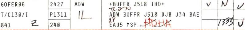
The written note “TL270” under BUFFR on the strip can be an initial standard heading indication.
The scribbled in time of 1333 could be the wheels-up time, local time 09:33.
That wheels-up time is not to be found in the above tape transcripts !
The plane seems not to have taken off. All other planes in this transcript have “off” and “down” times noted.
What does the “XY” scribble mean?
And the red “HDHA” writings, penciled off in that way?
And what mean the other scribbles on this flight strip? (“Z”, “IL”, “V “, and “N” )
The tapes do also give some very important info on a heated debated subject in this and many other forums, namely, that a second NECAP 747, also known as the Doomsday plane, namely VENUS 77 did fly through Class B airspace, see the 09:40 transcripts time stamp:
Note also, that the first NECAP plane, VENUS 22 (I assume that, since it was a 747, has the same call sign, only a different number, 22) was cleared for takeoff on Andrews AFB at 09:14:30, was reported off at 0916 to Base Ops, but landed again at Andrews, reported to Base Ops 0954, down.
And this time I am sure that nobody believes that a NECAP plane can be put on the runway in a few minutes. Thus, it must have cost considerable time to put that plane on the runway, before her takeoff time. It looks as if they knew what was coming.
It flew around exactly the critical 45 minutes covering the Flight 77 impact time.
Why did it not stay in the air? They can be refueled easily. In addition, have considerable more airtime in their tanks than 45 minutes.
What was the reason to land back again at Andrews AFB after just 45 minutes?
Thus, there were two NECAP’s in the Washington airspace, both stationed at Andrews AFB on 9/11 and the FAA and the Military wanted to give the impression to the 9/11 Commission that they were taken fully off-guard. And remember, Andrews AFB was not their home base.
Does it look as if these guys were totally taken off-guard?…..Sure. Or not?
Did you ever wonder where the only other, third NECAP plane was flying on 9/11?
A nice goal for a next FOIA request.
These are a few internal 9/11 Commission memorandums regarding missing documents and tapes from 9/11, not produced by the DoD entities. In there the notion is expressed, that not even one THIRD of the available tapes and transcripts were produced, and a feeling of counter productivity from the side of the DoD is expressed in there :
9/11 Commission Memo Complaining about Lack of Documents from the Pentagon:
www.scribd.com...
9/11 Commission Memo Saying Pentagon Has Not Produced All Documents Related to Otis Air Force Base :
www.scribd.com...
9/11 Commission E-mail about Outstanding Issues with the Defense Department from September 2003 :
www.scribd.com...
(Weed, I am going to study your audio times explanation, had to post this first, since I lost this whole post already one time, this is the second one I wrote from memory and still available web sites.)
These tape transcripts from Andrews Air Force Base do give some more timed info on the C-130 GOFER 06, piloted by O’Brien :
DH B4 Andrews AFB Logs-Timelines Fdr- Relevant Andrews Transmissions- Miles Kara Notes097 :
www.scribd.com...
08:26:33 (Tape 7982 C1B, Ground Control) Gofer 06 on transit ramp, radiocheck
09:20:44: (Tape 7982 C1A, Ground Control) Asks Gofer 6 how he spells his call sign.
Answer: Golf, Oscar, Foxtrot, Echo, Romeo.
[Note: Go figure. Why the Minnesota Guard would opt for Gofer over Gopher is baffling.]
09:26:30: (Tape 7982 C1A, Ground Control) Ground Control verifies Word 31 and Gofer 06 to Washington Flight Data. [Note: this is the cue that allowed National Tower to know that a military aircraft was taking off to proceed west ]
09:28:35: (Tape 7982 B1B, Arrival Radar) Gopher 06, released (LT: Note the wrong name Gopher)
09:30:40; (Tape 7982 C1A, Ground Control) Ground Control gives Gofer 06 permission to taxi to runway 1L
09:30:50: (Tape 7981 A1B, Local Control) Gofer 06 cleared for takeoff, not reported to Base Ops
09:31:40 (Tape 7982 C1A, Ground Control) Gofer 06 requests temporary hold to enhance INS system
That National Guard C-130 stood still or taxied for more than 1 hour.
Is that normal for military take-offs? There is no takeoff time noted in these tape transcripts, which is strange.
You nearly should think that that plane was waiting for a special task in a special time window.
We also have a very peculiar flight strip for the GOFER 06 take-off data :
The written note “TL270” under BUFFR on the strip can be an initial standard heading indication.
The scribbled in time of 1333 could be the wheels-up time, local time 09:33.
That wheels-up time is not to be found in the above tape transcripts !
The plane seems not to have taken off. All other planes in this transcript have “off” and “down” times noted.
What does the “XY” scribble mean?
And the red “HDHA” writings, penciled off in that way?
And what mean the other scribbles on this flight strip? (“Z”, “IL”, “V “, and “N” )
The tapes do also give some very important info on a heated debated subject in this and many other forums, namely, that a second NECAP 747, also known as the Doomsday plane, namely VENUS 77 did fly through Class B airspace, see the 09:40 transcripts time stamp:
09:38:40: (Tape 7982 B2A, Arrival Radar) National called, we're stopped.
Answer, you're stopped?
09:39: (Tape 7981A2A, Local Control, time approximate) Wash to Andrews, hold all ground departures
09:40: (Tape 7981A2A, Local Control, time approximate) Venus 77 on freq, need clearance direct Offut, will take off VFR to the east and get clearance later. Cleared Mode 0310 through Class B airspace
09:41: (Tape 7981A2A, Local Control, time approximate) Venus 77 cleared for takeoff
09:42:28: (Tape 7982 B2A, Arrival Radar) Tower to Arrival Radar, Venus 77, 747, a NECAP aircraft, he's going to take off VFR to the east, trying to get to Offut air base, he is not going to wait, already talked to Washington and we'll work out something
09:42:58: (Tape 7982 B2A, Arrival Radar) Tower to Arrival Radar re Venus 77, We're going to give him to Washington, standard east departure and we want a release on him now. Answer: Released.
09:44:41: (Tape 7982 B2A, Arrival Radar) Venus 77, heavy, set to go, talking to Washington ATC reported to Base Ops as 09:45 off. Flight Strip 0945
09:47:19: (Tape 7982 B2A, Arrival Radar) Venus 22 given visual to land on runway 1L, contact tower
09:47: (Tape 7981A2A, Local Control, time approximate) Venus 22 to land, will do 360 to burn off fuel
09:49: (Tape 7981A2A, Local Control, time approximate) Venus 22 cleared to land, reported to Base Ops 0954, down.
09:49:20: (Tape 7982 B2A, Arrival Radar) Printer message, advisory #7, advised all airborne traffic to pick a divert and land as soon as possible
09:53:20 (Tape 7982E TlS2, Local South) U/I says tell Ops we are going to recover the Bullys. There follows a conversation about a B747coming to Andrews. Tower has no knowledge unless it is Venus 77. (LT: VENUS 22 which landed 0954?)
Note also, that the first NECAP plane, VENUS 22 (I assume that, since it was a 747, has the same call sign, only a different number, 22) was cleared for takeoff on Andrews AFB at 09:14:30, was reported off at 0916 to Base Ops, but landed again at Andrews, reported to Base Ops 0954, down.
And this time I am sure that nobody believes that a NECAP plane can be put on the runway in a few minutes. Thus, it must have cost considerable time to put that plane on the runway, before her takeoff time. It looks as if they knew what was coming.
It flew around exactly the critical 45 minutes covering the Flight 77 impact time.
Why did it not stay in the air? They can be refueled easily. In addition, have considerable more airtime in their tanks than 45 minutes.
What was the reason to land back again at Andrews AFB after just 45 minutes?
Thus, there were two NECAP’s in the Washington airspace, both stationed at Andrews AFB on 9/11 and the FAA and the Military wanted to give the impression to the 9/11 Commission that they were taken fully off-guard. And remember, Andrews AFB was not their home base.
Does it look as if these guys were totally taken off-guard?…..Sure. Or not?
Did you ever wonder where the only other, third NECAP plane was flying on 9/11?
A nice goal for a next FOIA request.
These are a few internal 9/11 Commission memorandums regarding missing documents and tapes from 9/11, not produced by the DoD entities. In there the notion is expressed, that not even one THIRD of the available tapes and transcripts were produced, and a feeling of counter productivity from the side of the DoD is expressed in there :
9/11 Commission Memo Complaining about Lack of Documents from the Pentagon:
www.scribd.com...
9/11 Commission Memo Saying Pentagon Has Not Produced All Documents Related to Otis Air Force Base :
www.scribd.com...
9/11 Commission E-mail about Outstanding Issues with the Defense Department from September 2003 :
www.scribd.com...
(Weed, I am going to study your audio times explanation, had to post this first, since I lost this whole post already one time, this is the second one I wrote from memory and still available web sites.)
Weed, still not came to study your answer, will do soon.
This needed posted first :
History Commons put some 9/11 Commission memo's and emails online.
Source: www.scribd.com...
9/11 Commission Memo Complaining about Lack of Documents from the Pentagon.
Conclusion: do not trust transcripts of audio tapes from 9/11.
Listen to the actual tapes instead, and time stamp them yourself.
This needed posted first :
History Commons put some 9/11 Commission memo's and emails online.
Source: www.scribd.com...
9/11 Commission Memo Complaining about Lack of Documents from the Pentagon.
1.
The transcript NEADS produced is fatally incomplete and inaccurate:
When we arrived at NEADS, we began to listen to the tapes from which the transcript was made.
It was apparent immediately - and acknowledged by NEADS officials - that there are significant relevant omissions in the transcript.Voices that are clearly audible in the tape were not transcribed. Moreover,significant portions of the transcript are simply inaccurate; the words on the paper do not track what is clearly heard on the tape. Put simply, the transcript is useless as a formal record of NEADS conversations from 9/11 and will have to be done over.
2.
The transcript of the tapes NEADS produced represents at best one-third of the total relevant recorded materials NEADS possesses from 9/11:
We discovered further that the one transcript produced by NEADS - which captures approximately five channels of communication - constitutes only a fraction - at best one-third - of the relevant recorded telephone lines in the facility. Specifically, we learned that the NEADS transcript does not reflect conversations by personnel assigned to key positions at the SOCC (Sector Operations ControlCenter) on 9/11.
As we understand it, there are 46 channels that can be recorded from the SOCC floor.
Of these 46 channels, only five or six were transcribed and produced to the Commission prior to our visit to NEADS.
--snip--
More broadly, Team 8 believes that the Commission's policy of accepting transcripts in lieu of factual recordings should be revisited in light of its experience with the NEADS tape.
Conclusion: do not trust transcripts of audio tapes from 9/11.
Listen to the actual tapes instead, and time stamp them yourself.
Please note that all my above linked-to photo's and drawings at the former picture upload site I used, ALX, are defunct, since that website is now
off the grid, for whatever reason.
I however uploaded all relevant ones for all my ATS posts in my personal ATS media profile.
media.abovetopsecret.com...
Look in my albums : "My Photos" and "Washington Airport TYSON tapes and flight strips".
Weedwhacker, please understand my expressed confusion by back-reading my earlier post and the following ones by me on page 6 :
www.abovetopsecret.com...
I also did remind the reader in the page 6 posts to re-read some of my posts on page 5 and earlier on.
I got totally confused by the erratic mode of anchoring and describing timelines by the FAA officials making these transcripts, and NEADS constructing their offered audio tapes.
If this kind of delivering data should be the norm in some professions, some really huge explosions would have been the result. It is sloppy behavior, and one can hardly believe that it seems to be normal inside DoD circles.
This suspicion was noted by the 9/11 Commission team 8 also, after visiting the NEADS facilities, see my above post.
I do not remember why I returned to the "start of tape is start of audio" reasoning, and I did not explain that in that post, but at that posting time, I thought it to be so obvious, that I forgot to include the reason.
After reading your explanation, I understood that you think that the events in the GOFER06 transcript list fit quite well with the audio events to be heard, which is reasonable, and I certainly do not contest that laid out line of events by you, but I do contest however the starting point and thus all the time stamps attached.
I thought I made it quite clear that the biggest discrepancies are between the GOFER06 timeline and the RADES radar data timeline and that there is no consistency between the GOFER06 and the RADES timestamps.
They differ in my opinion far too far, in fact about 64 seconds.
[atsimg]http://files.abovetopsecret.com/images/member/3de077ed2eb1.jpg[/atsimg]
[atsimg]http://files.abovetopsecret.com/images/member/bd702d114188.jpg[/atsimg]
If you look at the full-screen RADES/NEADS video, and use the slider in the Google video screen and slide it fast from the start to impact, you will find the time (at the top of the screen) that GOFER06 had the 757 straight ahead, at his 12 o'clock position. It's around 09:36:03,396 EDT time.
( video.google.com... )
If you look in one of my posts at this page above, in the by SPreston linked drawing of time-stamped events, at the 64 seconds later than the 12 o'clock position of both the GOFER06 and AAL77, you will find AAL77 at around 09:37:00.
And that was already past the point that it crossed its former circling south path again, straight back again on its route to the Pentagon.
And thus certainly not near, or at some sort of 12 o'clock position.
[atsimg]http://files.abovetopsecret.com/images/member/7904ae38c716.jpg[/atsimg]
I saw an assumption in your first lines, where you build your whole reasoning on, which can not be proved by assertion itself as a stand alone piece of evidence. I bolded that assumption where you used the word "occurred" :
In fact, the person who transcribed the audio tape, wrote that and the other time stamps in there, and since we have to have an "anchor"-starting-time provided by the same person, for him/her to be able to pinpoint that event to a certain time stamp, we have to start somewhere to deduce such a stamp he/she could have used.
1. First, that would be the accompanying letter written by the official who send the FOIA requested FAA data to the applicant. And there we only find a time frame described for the events listed and transcribed, between 09:25 to 09:48. (Which is not precise enough, no seconds are inhibited in that time frame).
However, the first transcribed event starts earlier than 09:25, in fact at 09:23:57: "WORD31 released off of Andrews". That, by the way, does not mean it departed, it means it got its clearance to start procedures for its departure which would follow shortly.
Thus, there is no clearly overlapping starting point ( verifiable with other trustful list(s) ), for the timestamped events in that list.
It is very important to note, in my opinion, those 63 seconds -earlier- time stamp (than the officially given starting time of the audio-tape as 09:25) of the first transcribed event in the FAA list, 09:23:57 !
And please note also, that first listed event can NOT be heard in that " DCA 108 TYSON " audio tape.
2. Secondly, and much more precise, it would be the RADES radar data and timestamps added to them that would give us the best possible "anchored" time stamps, to certify certain verifiable events described in the FAA list of events, with among them the GOFER06 transcripts of the audio tape(s).
RADES radar timestamps will be based on atomic clock read-outs.
Certain events in that GOFER06 timeline must be found which we all can agree on, and which describe a precise enough position of one of the planes described in the transcripts or heard in the audio file which we can hook on to observable identical RADES data and accompanying time stamps.
Only then can we check ourself if the whole time lined list of events have the right time stamps addressed.
Or if we have to add or subtract some or more seconds to all time stamps of the events described.
I have a strong suspicion that we will have to do this, to come to the real starting and ending time stamps for all the planes involved in that RADES simulation. Because I found 64 seconds difference for one same event between the RADES data and the audio tape data time stamps attached.
I myself opted for the moments Andrews TRACON controller said he saw "the plane" at O'Brien's eleven o'clock position, and then O'Brien directly commented on that remark by telling him that in fact the plane was already at his twelve o'clock position.
And since we have quite a clear RADES/NEADS data animated video made by John Farmer or another person, where we can see a certain point in time when GOFER06 is straight in line with the 757, at the C-130 pilot O'Brien's 12 o'clock position to the attack plane.
That time stamp in the RADES data and the time stamp in the audio file and its transcript differ far too much ( 64 seconds ), such that you can explain it away with time-delayed uncertainties in radio connections, map points or radar anomalies.
If you listen to the tape, you can hear clearly that the conversation between the Andrews TRACON flight operator and Lt Col. O'Brien in the GOFER06 C-130 plane was a fluent one, with no distinguishable pauses in it, at the moments that O'Brien was told about his eleven o'clock position to flight 77 and IMMEDIATELY reported back his then twelve o'clock position related to the attack plane.
There was DEFINITELY no 64 seconds delay to be found in that quite exact description of two positions, and those two positions are clearly visible in the RADES/NEADS animated video I linked to already above.
My link name of that video is :
9_11_ Rades radar imagery with NEADS audio time matched - Pentagon Area.mp4
video.google.com...
(NEADS = North East Air Defense Sector of NORAD.)
It could be that the 63 seconds that the audio tape starts earlier than the given starting point of that audio tape has something to do with the clearly 64 seconds RADES radar data difference of the "12 o'clock" position time stamp of C-130 pilot O'Brien.
One thing is certain, the delivery of FOIA requested data by concerned citizens towards them, is far too slow, and far too sloppy in its format. The officials working on them should be more investigative, asking finer details first from the requester, before responding with perhaps the wrong material, like too small time frames etc.
The present FOIA delivery seems deliberately confusing, from one concrete set standpoint to another opposing concrete set standpoint.
When will we ever see the day that FOIA requested data is not obscured by non-neutrality based senders?
I found it particularly unbelievable that we have no officially released seismic charts from the impact of a plane at the Pentagon west wall, since we have several 9/11 news reports about books falling off book-shelfs in houses more than one mile away from the impact. We however have no times connected to these events.
A seismic record for such an event should be present, and it is one of the most suspicious lacks of evidence for the Pentagon event on 9/11 .
I however uploaded all relevant ones for all my ATS posts in my personal ATS media profile.
media.abovetopsecret.com...
Look in my albums : "My Photos" and "Washington Airport TYSON tapes and flight strips".
Weedwhacker, please understand my expressed confusion by back-reading my earlier post and the following ones by me on page 6 :
www.abovetopsecret.com...
I also did remind the reader in the page 6 posts to re-read some of my posts on page 5 and earlier on.
I got totally confused by the erratic mode of anchoring and describing timelines by the FAA officials making these transcripts, and NEADS constructing their offered audio tapes.
If this kind of delivering data should be the norm in some professions, some really huge explosions would have been the result. It is sloppy behavior, and one can hardly believe that it seems to be normal inside DoD circles.
This suspicion was noted by the 9/11 Commission team 8 also, after visiting the NEADS facilities, see my above post.
I do not remember why I returned to the "start of tape is start of audio" reasoning, and I did not explain that in that post, but at that posting time, I thought it to be so obvious, that I forgot to include the reason.
After reading your explanation, I understood that you think that the events in the GOFER06 transcript list fit quite well with the audio events to be heard, which is reasonable, and I certainly do not contest that laid out line of events by you, but I do contest however the starting point and thus all the time stamps attached.
I thought I made it quite clear that the biggest discrepancies are between the GOFER06 timeline and the RADES radar data timeline and that there is no consistency between the GOFER06 and the RADES timestamps.
They differ in my opinion far too far, in fact about 64 seconds.
[atsimg]http://files.abovetopsecret.com/images/member/3de077ed2eb1.jpg[/atsimg]
[atsimg]http://files.abovetopsecret.com/images/member/bd702d114188.jpg[/atsimg]
If you look at the full-screen RADES/NEADS video, and use the slider in the Google video screen and slide it fast from the start to impact, you will find the time (at the top of the screen) that GOFER06 had the 757 straight ahead, at his 12 o'clock position. It's around 09:36:03,396 EDT time.
( video.google.com... )
Google Video Link |
If you look in one of my posts at this page above, in the by SPreston linked drawing of time-stamped events, at the 64 seconds later than the 12 o'clock position of both the GOFER06 and AAL77, you will find AAL77 at around 09:37:00.
And that was already past the point that it crossed its former circling south path again, straight back again on its route to the Pentagon.
And thus certainly not near, or at some sort of 12 o'clock position.
[atsimg]http://files.abovetopsecret.com/images/member/7904ae38c716.jpg[/atsimg]
I saw an assumption in your first lines, where you build your whole reasoning on, which can not be proved by assertion itself as a stand alone piece of evidence. I bolded that assumption where you used the word "occurred" :
Now, pay attention: WORD31 Heavy was 'issued maintain 3000' according to the Pinnacle transcript. This occurred at 13:27:06 UTC.
In fact, the person who transcribed the audio tape, wrote that and the other time stamps in there, and since we have to have an "anchor"-starting-time provided by the same person, for him/her to be able to pinpoint that event to a certain time stamp, we have to start somewhere to deduce such a stamp he/she could have used.
1. First, that would be the accompanying letter written by the official who send the FOIA requested FAA data to the applicant. And there we only find a time frame described for the events listed and transcribed, between 09:25 to 09:48. (Which is not precise enough, no seconds are inhibited in that time frame).
However, the first transcribed event starts earlier than 09:25, in fact at 09:23:57: "WORD31 released off of Andrews". That, by the way, does not mean it departed, it means it got its clearance to start procedures for its departure which would follow shortly.
Thus, there is no clearly overlapping starting point ( verifiable with other trustful list(s) ), for the timestamped events in that list.
It is very important to note, in my opinion, those 63 seconds -earlier- time stamp (than the officially given starting time of the audio-tape as 09:25) of the first transcribed event in the FAA list, 09:23:57 !
And please note also, that first listed event can NOT be heard in that " DCA 108 TYSON " audio tape.
2. Secondly, and much more precise, it would be the RADES radar data and timestamps added to them that would give us the best possible "anchored" time stamps, to certify certain verifiable events described in the FAA list of events, with among them the GOFER06 transcripts of the audio tape(s).
RADES radar timestamps will be based on atomic clock read-outs.
Certain events in that GOFER06 timeline must be found which we all can agree on, and which describe a precise enough position of one of the planes described in the transcripts or heard in the audio file which we can hook on to observable identical RADES data and accompanying time stamps.
Only then can we check ourself if the whole time lined list of events have the right time stamps addressed.
Or if we have to add or subtract some or more seconds to all time stamps of the events described.
I have a strong suspicion that we will have to do this, to come to the real starting and ending time stamps for all the planes involved in that RADES simulation. Because I found 64 seconds difference for one same event between the RADES data and the audio tape data time stamps attached.
I myself opted for the moments Andrews TRACON controller said he saw "the plane" at O'Brien's eleven o'clock position, and then O'Brien directly commented on that remark by telling him that in fact the plane was already at his twelve o'clock position.
And since we have quite a clear RADES/NEADS data animated video made by John Farmer or another person, where we can see a certain point in time when GOFER06 is straight in line with the 757, at the C-130 pilot O'Brien's 12 o'clock position to the attack plane.
That time stamp in the RADES data and the time stamp in the audio file and its transcript differ far too much ( 64 seconds ), such that you can explain it away with time-delayed uncertainties in radio connections, map points or radar anomalies.
If you listen to the tape, you can hear clearly that the conversation between the Andrews TRACON flight operator and Lt Col. O'Brien in the GOFER06 C-130 plane was a fluent one, with no distinguishable pauses in it, at the moments that O'Brien was told about his eleven o'clock position to flight 77 and IMMEDIATELY reported back his then twelve o'clock position related to the attack plane.
There was DEFINITELY no 64 seconds delay to be found in that quite exact description of two positions, and those two positions are clearly visible in the RADES/NEADS animated video I linked to already above.
My link name of that video is :
9_11_ Rades radar imagery with NEADS audio time matched - Pentagon Area.mp4
video.google.com...
(NEADS = North East Air Defense Sector of NORAD.)
It could be that the 63 seconds that the audio tape starts earlier than the given starting point of that audio tape has something to do with the clearly 64 seconds RADES radar data difference of the "12 o'clock" position time stamp of C-130 pilot O'Brien.
One thing is certain, the delivery of FOIA requested data by concerned citizens towards them, is far too slow, and far too sloppy in its format. The officials working on them should be more investigative, asking finer details first from the requester, before responding with perhaps the wrong material, like too small time frames etc.
The present FOIA delivery seems deliberately confusing, from one concrete set standpoint to another opposing concrete set standpoint.
When will we ever see the day that FOIA requested data is not obscured by non-neutrality based senders?
I found it particularly unbelievable that we have no officially released seismic charts from the impact of a plane at the Pentagon west wall, since we have several 9/11 news reports about books falling off book-shelfs in houses more than one mile away from the impact. We however have no times connected to these events.
A seismic record for such an event should be present, and it is one of the most suspicious lacks of evidence for the Pentagon event on 9/11 .
reply to post by LaBTop
That post is just too much to digest, not sure where to begin.
But....in the 'google' video, at 09:36:03,396 I just don't hear what you claim?? That is a recording of the landline communications between ATC people, NOT the radio comm?
Perhaps I'm confused by your points.
As to this:
I was living a little more than a mile away, at the time. Look for "Lyon Park", corner of Pershing Drive and Fillmore Street.
What I felt, at roughly 1000, was a slight shake of the house. This would co-incide with the Pentagon structure collapse, NOT the airplane impact.
Seismic charts? That's a new one....has anyone looked for them?
That post is just too much to digest, not sure where to begin.
But....in the 'google' video, at 09:36:03,396 I just don't hear what you claim?? That is a recording of the landline communications between ATC people, NOT the radio comm?
Perhaps I'm confused by your points.
As to this:
I found it particularly unbelievable that we have no officially released seismic charts from the impact of a plane at the Pentagon west wall, since we have several 9/11 news reports about books falling off book-shelfs in houses more than one mile away from the impact. We however have no times connected to these events.
I was living a little more than a mile away, at the time. Look for "Lyon Park", corner of Pershing Drive and Fillmore Street.
What I felt, at roughly 1000, was a slight shake of the house. This would co-incide with the Pentagon structure collapse, NOT the airplane impact.
Seismic charts? That's a new one....has anyone looked for them?
new topics
-
Shocking moment four men 'try to force Jewish pedestrian into car boot' in North London
Breaking Alternative News: 4 minutes ago -
The 'Censorship-Industrial Complex'. It is coming to a nation state near you, any time now...
New World Order: 54 minutes ago -
BREAKING: Astrazeneca admits for the first time its vaccine can cause deaths and serious injuries
Medical Issues & Conspiracies: 4 hours ago -
New Bombshell Evidence Strongly Suggests Trump was Set Up in Classified Docs Saga
US Political Madness: 9 hours ago
top topics
-
New Bombshell Evidence Strongly Suggests Trump was Set Up in Classified Docs Saga
US Political Madness: 9 hours ago, 27 flags -
Jim Biden Was in Business with Qatari Officials
US Political Madness: 17 hours ago, 13 flags -
Expert Says Parents Should Ask Babies Permission to Change Nappies.
General Chit Chat: 13 hours ago, 10 flags -
BREAKING: Astrazeneca admits for the first time its vaccine can cause deaths and serious injuries
Medical Issues & Conspiracies: 4 hours ago, 8 flags -
I may have had a talk with Pope Francis about his plans for our nation
The Gray Area: 17 hours ago, 6 flags -
One More Night at the Pig and Blanket (Time 2024)
Short Stories: 12 hours ago, 5 flags -
Do you name your cars ?
General Chit Chat: 15 hours ago, 4 flags -
Hard evidence of a Royal plot on the US....if only i had proof.
ATS Skunk Works: 14 hours ago, 2 flags -
The 'Censorship-Industrial Complex'. It is coming to a nation state near you, any time now...
New World Order: 54 minutes ago, 1 flags -
Shocking moment four men 'try to force Jewish pedestrian into car boot' in North London
Breaking Alternative News: 4 minutes ago, 1 flags
active topics
-
Shocking moment four men 'try to force Jewish pedestrian into car boot' in North London
Breaking Alternative News • 1 • : FlyersFan -
The 'Censorship-Industrial Complex'. It is coming to a nation state near you, any time now...
New World Order • 2 • : CosmicFocus -
New whistleblower Jason Sands speaks on Twitter Spaces last night.
Aliens and UFOs • 79 • : andy06shake -
The Acronym Game .. Pt.3
General Chit Chat • 7766 • : F2d5thCavv2 -
New Bombshell Evidence Strongly Suggests Trump was Set Up in Classified Docs Saga
US Political Madness • 39 • : xuenchen -
Russia Ukraine Update Thread - part 3
World War Three • 5742 • : F2d5thCavv2 -
Sleep paralysis and the implantation of some weird Matrix-esque demon creature...
The Gray Area • 12 • : Compendium -
-@TH3WH17ERABB17- -Q- ---TIME TO SHOW THE WORLD--- -Part- --44--
Dissecting Disinformation • 723 • : Imbackbaby -
Hard evidence of a Royal plot on the US....if only i had proof.
ATS Skunk Works • 31 • : andy06shake -
SETI chief says US has no evidence for alien technology. 'And we never have'
Aliens and UFOs • 83 • : andy06shake