It looks like you're using an Ad Blocker.
Please white-list or disable AboveTopSecret.com in your ad-blocking tool.
Thank you.
Some features of ATS will be disabled while you continue to use an ad-blocker.

FAA or 84RADES data falsified, or both.
page: 1share:
The reader will first need an understanding of the term „heading“, therefore I give a picture of a heading compass here:

If a plane is advised to move to a heading of 270, it means that it must keep flying due west. If the flight controller instruct the plane’s pilots then to change to a heading of 330, it means that it must make a 60° bank to the right from heading 270 to a new heading of 330.
See the last three lines of the FAA GOPHER06 list in the Pinnacle PDF FOIA released document.
The list above the compass is a compilation of only the GOPHER06 data taken out of the Pinnacle PDF data by Reheat, some line's texts are cut-off at the right side, and the line where the C-130 issued to be on radar at what altitude (3000 foot) is left out.
For the full readable FAA communication, go here:
Pinnacle documents PDF : aal77.com...
It has also the take-off times for the other planes involved, in it. That is a puzzle in itself, but I think I solved part of it.
I compared identical numbers written in obvious the same handwriting for all four depicted planes, and then deducted which numbers were written by comparing same numbers written in different spots.
P1230: BOBCAT 14 and 17 has a planned take-off from Dover AFB. (Page 4 of 6 from the PDF file)
P1330: SWORD31 has a planned take-off from Andrews AFB. (Page 4 of 6 from the PDF file)
13:23:57 SWORD31’s reported take-off from Andrews AFB. (Page 5 of 6 from the PDF file)
P1311: GOPHER06 has a planned take-off from Andrews AFB. (Page 4 of 6 from the PDF file)
13:29:39 GOPHER06’s reported take-off from Andrews AFB. (Page 5 of 6 from the PDF file)
Page 4 of the PDF is interesting, especially the written and then stroked-out numbers, they are compass headings given by the control tower, and were stroked-out when a new heading was given.
We therefore observe the following subsequent headings given and written down by hand to the following USAF planes:
SWORD31: Take-off from Andrews AFB, first heading 35, then 40, then 150 (see third column ADW), then some strange scribble in the fourth column, which could mean here, that the final heading was not known or may not be registered. It could be that the 120 heading written by hand in the first column could have been the initial planned heading for the final heading when at cruising height and speed.
It looks that this plane had been ordered by ADW (Andrews AFB tower) to join a task force named J149 in the air, since it was “empty” at take-off, which can mean that it took-off as a single plane, with no immediate fighter escort. Ordered also to fly a J80 CAP, which is a patrol task in the air to secure a region.
BOBCT17: Planned take-off to fly to a bombing range, from Dover AFB, reported take-off time not visual, first heading 170, then 260, then 230 (see third column P1230), then 210 (fourth column), then perhaps a final heading of 284.7 (see column 1).
BOBCT14: An identical pattern, however the 260 heading written for BOBCT17 is missing.
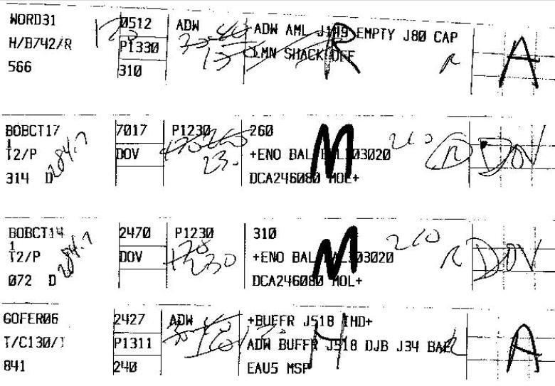
GOPHER06: Take-off from Andrews AFB, first heading 35, then 40, then 160, then 120 (see third column ADW). The first two headings are the same as for SWORD31, and the third heading is 10° more than SWORD31.
Therefore, they both took off in the Camp Springs One Runway 1L/1R configuration according to that page 4 from 6 from the FAA PDF file.
However, they did not follow the required radar vectors flight path, when we compare the above found handwritten numbers to the following plotted RADES radar returns so eloquently depicted by John Farmer.
They took off to the right instead of to the left as is mandatory in normal situations.
But we know that FAA flight controllers were vehemently whisking away any traffic from the incoming flight 77, so that’s why they instructed the C-130 and the SWORD 31 B742 plane to divert from normal take-off procedure, fly off to the right side and therefore avoiding the incoming hijacked traffic with unknown intentions.
This is the John Farmer plotted take-off and following flight path from the C-130, in line with the RADES data, which however does not line-up AT ALL with the written headings by the FAA radar operator, Mr. Robert F. Smoak :
This is John Farmers post at his 911files.info/blog :
GOPHER6 Tidbits
911files.info...
Where you can find the following Camps Springs One Departure radar vectors required within 10 nautical miles from departure from USAF Andrews AFB with the plotted-in C-130 required flight path, which it however did not follow when observing the handwritten headings by the FAA flight controller:

This is the heading compass drawing again, but now with North up:
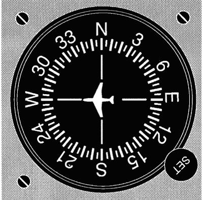
Please note that heading 35 is situated one small stripe further than the “3” to the right of the “N”.
Heading 120 is situated at the “12” position, three big stripes further than the “E”.
Mr. Robert F. Smoak seems to have been the FAA supervisor on duty on 9/11, he signed for all four planes in the fourth column with a regular small “r”, and signed personally for the SWORD31 plane, with a capital “R”. He indicates with that big “R”, that he was the flight controller for that SWORD31 plane.
This clear discrepancy between the RADES radar data, and the FAA Communications Report can ONLY mean one thing, one of these reports is false, or both are false!
A common result of the “human error” factor at work, the RADES and/or FAA reports fixers did probably check the printed text, but clearly not the handwritten text.
I tend to believe the RADES data are completely, or partially false.
[edit on 12/9/08 by LaBTop]
[edit on 12/9/08 by LaBTop]
DEDUCTIONS from FAA + RADES data and CIT's latest witness info.
I advice to first scroll down to the red texts in the above post, read the appropriate surrounding texts, and then start reading the rest of my posts and all their linked information.
We should as far as possible, adhere to officially and publicly published evidence in the 9/11 forums, so we can compare it, and see if it truly coincides with each other.
Thus, we will avoid assumptions, opinions and outlandish claims.
Introduction:
There is a plethora of information to extract from the following officially endorsed two links.
The first one links to the FOIA requested data for the FAA flight controller communications between the Washington Airport (formerly named Reagan International) control tower and a few USAF planes in the air on 9/11/2002.
It has UTC time stamps attached.
The second one and others, links to part or total of the RADES radar tracking data for all the planes in Washington DC and surrounding airspace during half an hour on the day of 9-11.
It has EDT time stamps attached.
Between EDT time 09:29:27,000 and EDT time 10:00:05,269, that RADES Google Video states that it covers a period of 30:33 from 30:38 total minutes and seconds.
I am interested in a much broader spectrum of periods than this one, for reasons that will become obvious when reading the rest of this post.
I downloaded the RADES video matched with the NEADS audio and opened it with Apple QuickTime Player version 7.4.5:
Pinnacle. PDF : aal77.com...
These are the, through FOIA requests obtained 9/11 FAA communications released reports.
All data is in UTC time. (Universal Time Code)
RADES data : video.google.com...
These are the radar data from the 84th RADES radar squadron, matched with the NEADS audio tape time. All data is in EDT time. (Eastern Daylight Time)
Other very interesting links to the RADES data:
The following links are John Farmers thorough RADES based calculations and his clear explanations of his view on flight 77’s officially endorsed flight path based on many publications of US institutions:
911files.info... : Earlier written blog page.
911files.info... : Latest written blog page.
911files.info...
RADES anomaly:
aal77.com...
RADES anomaly NTSB documents:
aal77.com...
The raw 84 RADES data is available for download at John Farmer’s site: AAL77.COM :
aal77.com...
Other calculations regarding the various difficulties interpreting the raw RADES data:
911files.info...
911files.info...
911files.info...
911files.info...
911files.info...
NEADS Radar Time Anomaly:
911files.info...
NEADS 25.3 Second Time Difference Explained, there is a 25.3 second time discrepancy in regards to the NEADS radar data.:
911files.info...
Flight path models :
911files.info...
911files.info...
John Farmers Flight Path Model, the Google Earth Model:
aal77.com...
This is a big JPEG, from which you can get an impression of the distances involved between various important radar stations and airfields involved with the RADES data, the NTSB data and the FAA data.
From south to north: Oceania Radar station, Langley AFB, Reagan International, Andrews AFB, Baltimore-Washington International, Dover AFB :
911files.info...
John Farmer’s C-130 and AAL77 flight path interaction, a Flash animation:
aal77.com...
A review (pdf) of the NEADS response to AAL77 by John Farmer:
aal77.com...
The CIT interview with Steve Chaconas:
www.youtube.com...
The explanation John Farmer gives for the plane Steve described:
911files.info...
His explanatory video:
www.youtube.com...
His explanation on March 1, 2008:
911files.info...
I want to explain at this spot, why I think John Farmer is not correct in his assumptions about the story Steve Chaconas told CIT.
Perhaps he did change his mind in the following months, after Craig possibly made some additions to his original video, to show John that he was mistaken to propose the plane identified with an M3 transponder code of 5174 as the plane Steve described, but I did not find proof of that in Farmer’s posts in his own blog pages.
Steve explained in his CIT interview, that the plane looked like a normal commercial airliner. He observed that it crossed the Potomac River near Reagan International, a bit south of it.
It was also a bit higher than the normal airliners approaching Reagan International for landing.
Then it made a wide loop over Crystal City, and disappeared near the Pentagon at the end of the loop. Directly after, he and his fishing clients saw a big explosion cloud.
Steve is definitely not describing a hastily landing at Reagan Airport’s runway nr 33, ordered by an FAA controller, of a light commuter plane, as John Farmer supposed.
This light plane departed at 09:12 from Easton Airport, a small airfield with two runways and flew in to Reagan International coming from that airport from the southeast, on a nearly straight flight path, making a slow bank when under the radar already, and then landed directly onto the northwest runway 33 at Reagan International.
That fits no big loop over Crystal City, which is Arlington, taking several minutes; Steve described it as a 3 minutes lasting long loop.
Pilots for Truth page:
pilotsfor911truth.org...
Additional references:
--------------------------------------------
9-11 "Mystery Plane" Closeup
www.youtube.com...
FAA data:
aal77.com...
CIT: The Pentagon Flyover - How They Pulled It Off. 100:09 min.
www.megavideo.com...
I advice to first scroll down to the red texts in the above post, read the appropriate surrounding texts, and then start reading the rest of my posts and all their linked information.
We should as far as possible, adhere to officially and publicly published evidence in the 9/11 forums, so we can compare it, and see if it truly coincides with each other.
Thus, we will avoid assumptions, opinions and outlandish claims.
Introduction:
There is a plethora of information to extract from the following officially endorsed two links.
The first one links to the FOIA requested data for the FAA flight controller communications between the Washington Airport (formerly named Reagan International) control tower and a few USAF planes in the air on 9/11/2002.
It has UTC time stamps attached.
The second one and others, links to part or total of the RADES radar tracking data for all the planes in Washington DC and surrounding airspace during half an hour on the day of 9-11.
It has EDT time stamps attached.
Between EDT time 09:29:27,000 and EDT time 10:00:05,269, that RADES Google Video states that it covers a period of 30:33 from 30:38 total minutes and seconds.
I am interested in a much broader spectrum of periods than this one, for reasons that will become obvious when reading the rest of this post.
I downloaded the RADES video matched with the NEADS audio and opened it with Apple QuickTime Player version 7.4.5:
Pinnacle. PDF : aal77.com...
These are the, through FOIA requests obtained 9/11 FAA communications released reports.
All data is in UTC time. (Universal Time Code)
RADES data : video.google.com...
These are the radar data from the 84th RADES radar squadron, matched with the NEADS audio tape time. All data is in EDT time. (Eastern Daylight Time)
Other very interesting links to the RADES data:
The following links are John Farmers thorough RADES based calculations and his clear explanations of his view on flight 77’s officially endorsed flight path based on many publications of US institutions:
911files.info... : Earlier written blog page.
911files.info... : Latest written blog page.
911files.info...
RADES anomaly:
aal77.com...
RADES anomaly NTSB documents:
aal77.com...
The raw 84 RADES data is available for download at John Farmer’s site: AAL77.COM :
aal77.com...
Other calculations regarding the various difficulties interpreting the raw RADES data:
911files.info...
911files.info...
911files.info...
911files.info...
911files.info...
NEADS Radar Time Anomaly:
911files.info...
NEADS 25.3 Second Time Difference Explained, there is a 25.3 second time discrepancy in regards to the NEADS radar data.:
911files.info...
Flight path models :
911files.info...
911files.info...
John Farmers Flight Path Model, the Google Earth Model:
aal77.com...
This is a big JPEG, from which you can get an impression of the distances involved between various important radar stations and airfields involved with the RADES data, the NTSB data and the FAA data.
From south to north: Oceania Radar station, Langley AFB, Reagan International, Andrews AFB, Baltimore-Washington International, Dover AFB :
911files.info...
John Farmer’s C-130 and AAL77 flight path interaction, a Flash animation:
aal77.com...
A review (pdf) of the NEADS response to AAL77 by John Farmer:
aal77.com...
The CIT interview with Steve Chaconas:
www.youtube.com...
The explanation John Farmer gives for the plane Steve described:
911files.info...
His explanatory video:
www.youtube.com...
His explanation on March 1, 2008:
911files.info...
I want to explain at this spot, why I think John Farmer is not correct in his assumptions about the story Steve Chaconas told CIT.
Perhaps he did change his mind in the following months, after Craig possibly made some additions to his original video, to show John that he was mistaken to propose the plane identified with an M3 transponder code of 5174 as the plane Steve described, but I did not find proof of that in Farmer’s posts in his own blog pages.
Steve explained in his CIT interview, that the plane looked like a normal commercial airliner. He observed that it crossed the Potomac River near Reagan International, a bit south of it.
It was also a bit higher than the normal airliners approaching Reagan International for landing.
Then it made a wide loop over Crystal City, and disappeared near the Pentagon at the end of the loop. Directly after, he and his fishing clients saw a big explosion cloud.
Steve is definitely not describing a hastily landing at Reagan Airport’s runway nr 33, ordered by an FAA controller, of a light commuter plane, as John Farmer supposed.
This light plane departed at 09:12 from Easton Airport, a small airfield with two runways and flew in to Reagan International coming from that airport from the southeast, on a nearly straight flight path, making a slow bank when under the radar already, and then landed directly onto the northwest runway 33 at Reagan International.
That fits no big loop over Crystal City, which is Arlington, taking several minutes; Steve described it as a 3 minutes lasting long loop.
Pilots for Truth page:
pilotsfor911truth.org...
Additional references:
Originally posted by Boone 870
reply to post by PplVSNWO
Yes.
No. I am not rejecting anything that O'Brien said before the release of the RADES data. I have based my beliefs on several sources.
www.youtube.com...://s1.zetaboards.com/LooseChangeForums/topic/42577/9/
www.cbc.ca...
s3.amazonaws.com...
news.minnesota.publicradio.org...
www.swirlspice.com...
www.minnesotanationalguard.org...
www.nydailynews.com...
www.youtube.com...
www.youtube.com...
911digitalarchive.org...
911digitalarchive.org...
911digitalarchive.org...
911digitalarchive.org...
www.clothmonkey.com...
simonsays.com...
aal77.com...
airnav.com...
Among others.
--------------------------------------------
9-11 "Mystery Plane" Closeup
www.youtube.com...
FAA data:
aal77.com...
CIT: The Pentagon Flyover - How They Pulled It Off. 100:09 min.
www.megavideo.com...
Note that Congressman Adam B. Schiff who filed the first FOIA to the USAF, made a big mistake to ask only info for the periods between 09:30 AM and
10:30 AM.
The other applicant, to the Secret Service, made the same mistake. In addition, he filed his FOIA just for the 09:30 AM to 10:00 AM periods.
Therefore, both the answers they received were conveniently negative, since the Doomsday plane seen and photographed circling at low altitude, probably under the main radars, above the White House was already gone from that restricted airspace before 09:30 AM.
I suspect SWORD31 to have been the Doomsday plane observed by so many reporters and bystanders, and that one took off from Andrews AFB at 09:23:57, and had time enough to make a slow, low turn above the White House under the normal radar coverage height of circa 3000 foot. At 13:27:06 it reported ""maintain 3000"" foot. In addition, at 09:30:07 it ""issued maintain 15000"" foot, thus already far out of sight when the two FOIA periods started. Its climb rate in three minutes seems too high to be a heavy airborne fuel tanker.
I found another highly interesting page of that FAA memorandum, where they described the agencies making communications, and the abbreviations. They made a strange mistake, the first plane taking off had a call sign "SWORD31", but in the time-framed communication transcripts pages they keep it naming "WORD31", that is quite a curious mistake.
In the US Air Force, it is common practice to append call signs like “Sword” to radar planes, and in the case of a doomsday plane, that call sign could be interpret as a "Sword of Damocles", threatening and hovering above the "enemy".
Have we thus found the take-off time for the white Doomsday plane seen and filmed flying over the White House? The one with the radar dome behind the cockpit. It is a converted 747, now renamed B742?
That possible Doomsday plane, SWORD31 climbed later on at considerable speed, however it took off slowly from Andrews AFB and in 189 seconds, it climbed slowly to 3000 foot, enough time to circle the White House once, probably under the main radars.
Under radar, because the C-130 call signed GOPHER06, ""told radar contact, maintain 3000"" foot altitude. My guess, less than 3000 foot in that airspace is under radar coverage.
Then SWORD31 climbed in 51 seconds from 3000 to 4000 foot, but then climbed in 131 seconds from 4000 to 15000 foot. Another 11000 foot.
Then after 82 seconds, it changed 180° compass heading, a full U-turn heading.
Peculiar behavior, and was there really no recorded communication with ground control at the FAA control room in the Washington Airport (TYSON/FLUKY) tower or the USAF Andrews AFB (ADW) tower ?
The SWORD31 is identified as a H/B742/R, is that R standing for Radar?
What stands the H for, the same H as for a C-130 version, the C-130-H?
ULTIMA posted lately a list of C-130 versions; the H version had some peculiar advantages.
What type of plane is a B742, is it a modified version of a 747, like the Doomsday plane supposedly is?
The GOPHER06 is identified as a T/C-130/I, is that I standing for Intelligence? And the T for Turbofan?
Craig, could you ask your friends at Pilots for Truth, to look into the strange headings from this SWORD31 plane, and with what plane or flight plan identified only as J-149 it joined and then resumed its own navigation?
Another strange thing, those handwritten headings in the second column on page 4 for the GOHER06 are not the same as for all its transcripts on page 5 and 6, which informed of its heading! However, they are the same for both the jet fighters! Check with the transcripts and compare with the handwritten additions by the FAA flight controller for all four planes, btw of course all four were USAF planes.
In addition, another strange thing, the GOPHER06 plane is not listed in the Abbreviations!
However, two others are, but they are non-existing in the transcripts.
One has a call sign AWE85, is that a call sign for an AWAC radar disc equipped USAF plane?
Excellent finding! It should be possible to plot these on a map to see what is happening.
Starred/flagged!
Starred/flagged!
reply to post by LaBTop
You should try another profession than making a hilarious attempt to decipher the Departure "strips" that you are so desperate to show are wrong.
There is simply too much wrong with this diatribe to address every issue, so I'll be concise and address only a few points. Suffice it to say that you have NO CLUE about what you've attempted to do.
These departure strips are send to the Control Tower by teletype from the agency responsible for issuing the IFR Clearance. In this case that would be TYSON (DCA TRACON) who has coordinated the clearance with the appropriate FAA ARTCC (Center). The hand written notes are entered by the Control Tower when the clearance is read to the pilot. The aircraft then switches to Departure Control (DCA TRACON) immediately after take-off. The respective Tower DOES NOT assign headings unless it is an amendment for a turn immediately after take-off. In any case, it would only be an initial turn, period. The tower then has NO KNOWLEDGE of any subsequent heading or altitude assignments, period.
So, those are NOT heading annotations. A heading of 035 degrees would not be written as 35 anyway. It would be written as 035 to distinguish a NE heading from 350 which would be a NW heading.
The "R" would be the only duty Tower Controller (a USAF person) who read the clearance to the pilot, not the FAA person who fulfilled the FOIA request. USAF towers are manned by Uniformed USAF personnel, not the FAA (with some exceptions for Joint Use Airports). Andrews is an AFB and is manned by Uniformed USAF personnel.
The codes following the type of aircraft are FAA communications and navigation equipment codes. An explanation for the codes would be found in the Airman's Information Manual (AIM).
Another clue that those are not headings annotated on the strips, would be the overall timing of the obvious positions of the C-130. There is simply not enough time between the take-off at ADW and the subsequent chain of events in the communications summary transcripts for your heading deviations to occur.
While both the Departure Control agency and the FAA Centers use similar strips they are merely for information purposes and do not include the type of annotations seen on these referenced here. Heading assignments would not be written on those anyway. The strips in your post are the ADW Tower strips.
One other error you state is that 3000' is below Radar coverage. It isn't. The altitude of radar coverage would vary due to several factors, but Radar coverage in that area would extend to WELL BELOW 3000'. In fact, both ADW Radar and DCA Radar had coverage of AA77 to quite a low altitude only about a mile or so from it's track to strike the Pentagon. Those files are also on AA77.com on the same page where you obtained the stuff you've posted.
Although I am not an ATC type person, I have spent enough time in and around tower operations to say that you're analysis is full of crap. All of this can easily be verified by someone with detailed experience in that area and if there are any additional posts praising this I will find someone with experience and slam this thread further into the ignorant file 13 where it belongs.
Reheat,
You beat me to it. I was down in Norfolk this past weekend, sitting in the BOQ reading the hilarious OP, waiting to get home to comment on this "gem".
Where to start.
This is so bad I'll even let Captain Bob address it. Just jump right in here wherever you want, Bob!
As Reheat pointed out, the "headings" the OP opined on are more screwed up than hogan's goat, and show the absolute complete and total ignorance and serves as prime evidence the author has no clue whatsoever what he is talking about.
The giggle machine on overdrive with this one. "Join a task force named J149"! Sounds good for the PffT Sky Kings! Actually, LaBtop. J-149 is a jet way that originates at the IAD vortac, heads outbound on a heading of 281 (minimum enroute altitude (MEA) 31000, which incidentally is the filed altitude for Sword 31, "310"), headed west.
Hey LaBtop - it was a good idea to ask Craig to get the Boys from PffT To help you out. Best wait for an answer before you post, though.
The clearance listed on your screen shot for Sword 31 is as follows:
which translated to the uninformed, is depart Andrews AFB (ADW), proceed to the fix known as ARMEL (AML), which is a vortac near Dulles, join jet route 149 (J149) fly on that route until you hit the fix named EMPTY (an intersection near Columbus, OH) join jet route 80 (J80) until you hit the waypoint TILMN in southern Indiana, then direct to SHACK, which is a fix on the Offutt, AFB (their destination) HI-ILS RWY 30 approach, then land at Offutt (OFF).
The other clearances on your screen shot reflect similar information: Gopher 06 was headed to a fix called BUFFR north of Dulles to join jet route J518, fly to the vortac fix called DJB (DRYER) near Cleveland, then join J-34 to a fix at EUA5, then direct to Minneapolis Saint Paul (MSP).
Really, LaBtop...unless your intent is to really, really look bad and put your buds over at CIT and PffT in a even worse light, you need to stay away from these sorts of things.
There are hilarious suppositions all throughout this thing:
Headings are never, ever given to a decimal point.
Reheat covered most everything else in this little piece.
And for the record, I'd hazard a guess (and that is all it is - a guess) that Sword 31 was diverted from its flight plan to Offutt to provide communications relay/link capabilities between the White House and the President, hence its appearance in the airspace above Washington that morning. I have no knowledge of what sort of a/c that was or what specific capabilities it had, but that would be my contribution to the guessing game.
I love how these "expert analysts" and "citizen investigators" open their mouths and engage their fingers in presenting such wonderful opinions and insights. Its one of the things that makes staying engaged with them so much fun! Problem is, aviation is not something you can look at and make up some cockamamie explanation for if you didn't know what J518 or J149 is or what the term EMPTY means in a filed flight plan.
Keep it up though, boys!
You beat me to it. I was down in Norfolk this past weekend, sitting in the BOQ reading the hilarious OP, waiting to get home to comment on this "gem".
Where to start.
If the flight controller instruct the plane’s pilots then to change to a heading of 330, it means that it must make a 60° bank to the right from heading 270 to a new heading of 330.
This is so bad I'll even let Captain Bob address it. Just jump right in here wherever you want, Bob!
As Reheat pointed out, the "headings" the OP opined on are more screwed up than hogan's goat, and show the absolute complete and total ignorance and serves as prime evidence the author has no clue whatsoever what he is talking about.
It looks that this plane had been ordered by ADW (Andrews AFB tower) to join a task force named J149 in the air, since it was “empty” at take-off, which can mean that it took-off as a single plane, with no immediate fighter escort. Ordered also to fly a J80 CAP, which is a patrol task in the air to secure a region.
The giggle machine on overdrive with this one. "Join a task force named J149"! Sounds good for the PffT Sky Kings! Actually, LaBtop. J-149 is a jet way that originates at the IAD vortac, heads outbound on a heading of 281 (minimum enroute altitude (MEA) 31000, which incidentally is the filed altitude for Sword 31, "310"), headed west.
Hey LaBtop - it was a good idea to ask Craig to get the Boys from PffT To help you out. Best wait for an answer before you post, though.
The clearance listed on your screen shot for Sword 31 is as follows:
ADW AML J149 EMPTY J80 LMN SHACK OFF
which translated to the uninformed, is depart Andrews AFB (ADW), proceed to the fix known as ARMEL (AML), which is a vortac near Dulles, join jet route 149 (J149) fly on that route until you hit the fix named EMPTY (an intersection near Columbus, OH) join jet route 80 (J80) until you hit the waypoint TILMN in southern Indiana, then direct to SHACK, which is a fix on the Offutt, AFB (their destination) HI-ILS RWY 30 approach, then land at Offutt (OFF).
The other clearances on your screen shot reflect similar information: Gopher 06 was headed to a fix called BUFFR north of Dulles to join jet route J518, fly to the vortac fix called DJB (DRYER) near Cleveland, then join J-34 to a fix at EUA5, then direct to Minneapolis Saint Paul (MSP).
Really, LaBtop...unless your intent is to really, really look bad and put your buds over at CIT and PffT in a even worse light, you need to stay away from these sorts of things.
There are hilarious suppositions all throughout this thing:
then perhaps a final heading of 284.7
Headings are never, ever given to a decimal point.
Reheat covered most everything else in this little piece.
And for the record, I'd hazard a guess (and that is all it is - a guess) that Sword 31 was diverted from its flight plan to Offutt to provide communications relay/link capabilities between the White House and the President, hence its appearance in the airspace above Washington that morning. I have no knowledge of what sort of a/c that was or what specific capabilities it had, but that would be my contribution to the guessing game.
I love how these "expert analysts" and "citizen investigators" open their mouths and engage their fingers in presenting such wonderful opinions and insights. Its one of the things that makes staying engaged with them so much fun! Problem is, aviation is not something you can look at and make up some cockamamie explanation for if you didn't know what J518 or J149 is or what the term EMPTY means in a filed flight plan.
Keep it up though, boys!
Never too old to learn.
I stood corrected already by the anonymous poster that posted after my last post, and before Reheat's and Pinch's posts.
Those were however also very informative, thanks for taking the time to insert quite some info between the few insults.
Those written numbers are altitudes.
The problem with the Anonymous posters still continues, their posts are not visible, even when accepted by any forum moderator.
Only when you log out, and read the forum also anonymous, you can see his/her informative post, so I don't understand, IF a mod read that Anon post, why they did not free it, to be read by all :
Pilots and flight controllers talking and writing has the same disadvantage for the uninformed reader as the prescription notes from a physician, they are both unreadable for the untrained eye.
I came to my mistaken conclusion by following as much logic as I could find in these FAA memorandums, and thus I wanted to follow up with this post, so bare with me, we know now that those scribblings were altitudes.
Nevertheless, its interesting enough to post it here :
We can try to extract periods and positions from a set of six photographs shot by Mr. Looney on 9-11, and a video shot by Mr. Tribby, filming the Pentagon about 1 minute after the smoke was rising.
Links to these data follow further on in this post.
For all these data, we base our comparisons on the pre recognition that they are not falsified and that they represent the facts.
If, however, we find contradicting evidence between these data sets, the problem arises, which data sets are falsified ones.
The outstanding conclusion to extract from the latest CIT witnesses is the fact that most of them describe a much slower flying Pentagon attack plane. The witness who is an experienced helipad flight-controller, Sean Boger, is the one who had the best training to make an educated guess about its speed when coming towards him.
Thus, let us find out if we can find corroborating evidence for a slower flying plane than proposed by the mainstream media and many official US institutions.
Flight path of the C-130 in the sky above the Pentagon on 9/11.
I found the four C-130 photos from mister Looney quite interesting, since after reviewing his hi-res JPEG pictures taken by him near the Pentagon on 9/11, one of them stood out to me, the nr 164.
Btw, I found two more, just as Undertow of www.aa77fdr.com... did too, who also found their time stamps (not set to real UTC time or real EDT time) registered by his camera settings and these photos are listed by me too:
911digitalarchive.org...
911digitalarchive.org...
911digitalarchive.org...
911digitalarchive.org...
911digitalarchive.org...
911digitalarchive.org...
The interesting fact observable in nr 164 is that the plane banked sharp to the right, just before Looney took this picture. A sharp right hand turn onwards a roughly northerly heading (330), just a few seconds before the photographer shot this picture, proved by the bended smoke trail.
We can see the plane flying on that new heading for approximately 0.5 to 1 km, which is how long the smoke trail seems to be.
Check the visible turn by moving your vertical screen slider up and down in the enlarged picture of the relatively sharp turn (~ 60 degrees) executed, requiring a sharp bank to the right.
Then you see the bended faint smoke trail from the C-130 turbo fan engines clearly jump up and down together with the blue sky.
Let us compare this turn captured in that Looney photo, to the FAA Pinnacle PDF last data entry for GOPHER06 on page 2 from the FAA communications (page 6/6 in the Pinnacle PDF), when the C-130 was instructed to make a 60° right turn to the northwest.
We will find a FAA Pinnacle PDF clocked UTC time of 13:40:40 for instructing this turn, from heading 270° to 330°.
This is however, no rock solid evidence that time stamp also fits the onset of the turn seen in the photo.
The pilot could have waited a few seconds before executing it. However, he waited no more than one minute later, I assume, and he definitely did not execute it earlier.
We can always ask the C-130 pilots and crew them selves, to get a more precise time stamp of the onset of that turn.
The last picture nr 164 from Mr. Looney has a camera time stamp of local time 8:34:05 according to “Undertow” (of www.aa77fdr.com), and when we roughly estimate the trajectories flown in nr 163 and 164, and compare them, it seems like the trajectory after the heading change took about 3 to 5 seconds.
Mr. Looney's camera time for this heading change, therefore must have read (when he would have shot a photo 3 to 5 seconds earlier, at the moment of the onset to the turn) as 8:34:00 to 8:34:03.
Which is UTC time 13:34:00 to eventually 13:34:03.
This is local DC time of 09:34:41,500, as a mean camera settings time for photo nr 164 from Mr. Looney, with an error margin of 2 seconds. Therefore, it could be 09:34:39,500 earliest and 09:34:43,500 latest.
[edit on 14/9/08 by LaBTop]
I stood corrected already by the anonymous poster that posted after my last post, and before Reheat's and Pinch's posts.
Those were however also very informative, thanks for taking the time to insert quite some info between the few insults.
Those written numbers are altitudes.
The problem with the Anonymous posters still continues, their posts are not visible, even when accepted by any forum moderator.
Only when you log out, and read the forum also anonymous, you can see his/her informative post, so I don't understand, IF a mod read that Anon post, why they did not free it, to be read by all :
Anonymous ATS
Icon depicting mood of postposted on 14-9-2008 at 02:48 AM
those are not headings, they are altitude assigned to the flight.Every altitude an ATCER assigns to an aircraft are written on the strip ,and once a previous given altitude is observed (by radar) or reported (by pilot on radio) left the ATCO cancel it.
Pilots and flight controllers talking and writing has the same disadvantage for the uninformed reader as the prescription notes from a physician, they are both unreadable for the untrained eye.
I came to my mistaken conclusion by following as much logic as I could find in these FAA memorandums, and thus I wanted to follow up with this post, so bare with me, we know now that those scribblings were altitudes.
Nevertheless, its interesting enough to post it here :
We can try to extract periods and positions from a set of six photographs shot by Mr. Looney on 9-11, and a video shot by Mr. Tribby, filming the Pentagon about 1 minute after the smoke was rising.
Links to these data follow further on in this post.
For all these data, we base our comparisons on the pre recognition that they are not falsified and that they represent the facts.
If, however, we find contradicting evidence between these data sets, the problem arises, which data sets are falsified ones.
The outstanding conclusion to extract from the latest CIT witnesses is the fact that most of them describe a much slower flying Pentagon attack plane. The witness who is an experienced helipad flight-controller, Sean Boger, is the one who had the best training to make an educated guess about its speed when coming towards him.
Thus, let us find out if we can find corroborating evidence for a slower flying plane than proposed by the mainstream media and many official US institutions.
Flight path of the C-130 in the sky above the Pentagon on 9/11.
I found the four C-130 photos from mister Looney quite interesting, since after reviewing his hi-res JPEG pictures taken by him near the Pentagon on 9/11, one of them stood out to me, the nr 164.
Btw, I found two more, just as Undertow of www.aa77fdr.com... did too, who also found their time stamps (not set to real UTC time or real EDT time) registered by his camera settings and these photos are listed by me too:
911digitalarchive.org...
911digitalarchive.org...
911digitalarchive.org...
911digitalarchive.org...
911digitalarchive.org...
911digitalarchive.org...
The interesting fact observable in nr 164 is that the plane banked sharp to the right, just before Looney took this picture. A sharp right hand turn onwards a roughly northerly heading (330), just a few seconds before the photographer shot this picture, proved by the bended smoke trail.
We can see the plane flying on that new heading for approximately 0.5 to 1 km, which is how long the smoke trail seems to be.
Check the visible turn by moving your vertical screen slider up and down in the enlarged picture of the relatively sharp turn (~ 60 degrees) executed, requiring a sharp bank to the right.
Then you see the bended faint smoke trail from the C-130 turbo fan engines clearly jump up and down together with the blue sky.

Let us compare this turn captured in that Looney photo, to the FAA Pinnacle PDF last data entry for GOPHER06 on page 2 from the FAA communications (page 6/6 in the Pinnacle PDF), when the C-130 was instructed to make a 60° right turn to the northwest.
We will find a FAA Pinnacle PDF clocked UTC time of 13:40:40 for instructing this turn, from heading 270° to 330°.
This is however, no rock solid evidence that time stamp also fits the onset of the turn seen in the photo.
The pilot could have waited a few seconds before executing it. However, he waited no more than one minute later, I assume, and he definitely did not execute it earlier.
We can always ask the C-130 pilots and crew them selves, to get a more precise time stamp of the onset of that turn.
The last picture nr 164 from Mr. Looney has a camera time stamp of local time 8:34:05 according to “Undertow” (of www.aa77fdr.com), and when we roughly estimate the trajectories flown in nr 163 and 164, and compare them, it seems like the trajectory after the heading change took about 3 to 5 seconds.
Mr. Looney's camera time for this heading change, therefore must have read (when he would have shot a photo 3 to 5 seconds earlier, at the moment of the onset to the turn) as 8:34:00 to 8:34:03.
Which is UTC time 13:34:00 to eventually 13:34:03.
This is local DC time of 09:34:41,500, as a mean camera settings time for photo nr 164 from Mr. Looney, with an error margin of 2 seconds. Therefore, it could be 09:34:39,500 earliest and 09:34:43,500 latest.
[edit on 14/9/08 by LaBTop]
More:
Has the C-130 confirmed to be a -H type? The C-130's co-pilot seems to have mentioned it in an interview to a newspaper, just once.
These are the ones capable of jamming electronics, and having drones on board, which when needed, are launched by it, while airborne.
See for my suspicion regarding the drones, this video:
www.youtube.com...
The above clip is a video clip from Samuel Anthony Ettaro and Dom Dimaggio from www.ettaro.com... , interviewing Susan McElwain who saw a small white drone crossing in front of her car, hopping over the tree line, banking to the right and then she saw a big explosion cloud, only a few hundred yards behind the trees in Shanksville. That was the spot where the media told us flight 93 went down. Her body language and tears when she told this, gives her a high credibility in my opinion.
The same C-130 commanded by Lt. Colonel O’Brien flew also very near the Shanksville event!
More and more the thought comes up that O'Brien and his crew were used as uninformed patsies, to lay eventual blame on, when the agency responsible for that drone seen by Mrs Susan McElwain, would be compromised in the future, after 9/11.
Was Shanksville definitely on their route to their Air Guard home base in Minnesota, straight from their last listed compass heading of 330° away from the Pentagon?
(See the last entry on page 6/6 from the Pinnacle PDF)
The C-130 landed first at Andrews, coming back from the Caribic region where it delivered or picked up some unnamed goods. Was it possibly a black operation flight? Did it perhaps pick up there that drone, observed by Susan McElwain flying near the Flight 93 "impact" hole?
I myself do not think so; black operatives never would appear on national television. However, O’Brien’s plane could easily have been used as an unaware coverage crew for the real black operative airplane, perhaps that Doomsday plane flying around, or the white (CIA?) plane seen in the sky at Shanksville.
That kind of info can only be extracted from official or secret records by a Congressional investigation.
Together with a row of FOIA requests for the full FAA time stamped communication data sets of the C-130 on its way back to their home base airfield.
And a FOIA request for full flight paths and communications time stamps for the 2 fighter jets (USAF BOBCAT14 and 17, call signs BCAT14 and BCAT17) and the Doomsday plane (USAF SWORD31?).
And the 2 other planes (CACTUS85 call sign AWE85 and COLGAN5981 call sign CJC5981) mentioned in the Pinnacle data set.
The USAF planes took off from Dover and Andrews AFB, and the two other planes were already flying perhaps, of which we have no transcripts provided in the FAA communication's two pages from that FOIA request (the Pinnacle PDF).
Could someone post the link to the RADES video with all the fast tiny moving dots in it, and the twin set of lighter dots depicting two jet fighters making a full circle, one of you surely has it at hand.
This is why I am very curious, this ULTIMA1 post about interception and shooting down of Flight 93, the two jet fighters involved, came from Andrews AFB according to the NSA sources from the 3 newspaper articles :
www.abovetopsecret.com...
I am also curious, if this last visible turn in photo nr 164 (also known from the FAA Memorandum list, at 13:40:40, changing from 270° to 330° compass heading, a 60° compass change), is also depicted in that RADES film of the full day of 9-11. The plane had to execute a relatively sharp turn (~ 60 degrees) requiring a sharp bank to the right, and so to see in the RADES video I put up above, it made such a turn northeast wards.
Can we also find the headings from the C-130, coming back from the Caribic region in the RADES video?
Thus, plot backwards, to find its original departure airfield that could have laid on a straight line to it, which I do not expect btw. Chances are not too low, that this plane was on a partly black operational mission and has flown evasive patterns.
I do not know if Craig's critics have studied this photo + two screen shot inlays, extensively enough:
i14.photobucket.com...
The only way to confirm the officially released RADES position of the C-130 in that photo is when Craig had the position of the car from Mr. Tribby wrong, or, his depicted green RADES path for the C-130 was placed in error.
To have the position of the car wrong, it must have passed that broad gray band from the concrete top of an underpass tunnel across I-395, to be able to change the yellow line pointer exactly in-between the 2 white block structures, and ending exactly at the knick in the green RADES position line, just after it passed over the Navy Annex building.
Now it ends up over the Arlington Cemetery at the red radius Craig painted on the map.
This contradicts the vectored-in, green RADES data line that has a sharp knick to the north just under the top of the photo.
Craig positioned the car however, exactly right.
See the following screen shot from my version of "Unreleased Pentagon 9-11 Footage.flv” :
We can see the two white cube-shaped structures. We also see the C-130 appearing just to the right of the upper part of the smoke column. If we "take aim" from the bottom center of the picture, through the space in between the two "cubes", we arrive at the gap in the bottom of the smoke column. That's the far right of the smoke, and thus the official impact point.
The C-130 is now visible, in the last part of its arc, flying behind the smoke column in the preceding seconds. Therefore, Craig’s calculation for the position of the car is right.
That leaves us with the only other possibility for his opponents to fit the RADES data with this visual evidence.
The green inlay line must have been pictured in a wrong position.
Well, can any opponent prove that case? Alternatively, disprove it, like Craig himself, or Pilots for Truth?
Note that the RADES path depicted by Craig differs about a mile or 1.5 kilometer from the observed real path in the Tribby video. That is not a fault within the acceptable radar error margin. It is far outside that radar margin.
I will however point already to the strongest evidence that Craig is right:
In the whole first part of the Tribby video, and in the 6 Looney photographs (especially the two first ones), we can't find a glimpse from the incoming C-130 to the left, southerly side (see the compass rose in Craig's above composite RADES photo) of the smoke column, on a heading known from the FAA Memorandum of 80°.
Only when leaving the smoke to the right side, and making a broad left turn, away from the two civilians their cameras.
If Craig's positioning of the green line of the official RADES path had to be moved to the right in its entirety, to fit the photographic evidence, then we must have observed the C-130 to the left of the smoke column in both the video and photo camera's evidence. That evidence we for sure do not observe.
Therefore, Craig's proposition is the only right one.
Remember, the radar’s 360° sweeps were probably around 12 seconds each, that's why, we see the straight lines connecting the "knick" points in the RADES data green line. If you want to know for sure for how many seconds, exactly that radar swept 360°, just measure the distances on the Google map, between all green radar points ("knick in the line), and then obtain the C-130 airspeeds for those periods via FOIA again. You could also interpolate the differences in distances (when the plane accelerated or decelerated), and arrive at a fairly correct sweep time (real-time arcs flown are not included, thus it's not a 100% accurate method). You have quite a lot of distance sets to interpolate, thus this will work fine for us now. A list of airspeeds could be composed then also, at these subsequent distances.
That would also be quite interesting, when interpolating distances at that fixed radar sweep time, for the airspeed of the attack plane. Because we deducted from the new CIT team witnesses interviews that they all stated that the plane flew considerably slower than has been told by several official institutes.
Especially important is the Sean Boger remark, he was the Pentagon's heliport-tower controller on 9/11, he stated that it took the attack plane far more than the 2 to 3 seconds from the official reports, to cover the distance from the Navy Annex to the Pentagon west wall. He talks about 6 to 8 seconds. Moreover, the others confirm that longer period too. Boger was an experienced USAF flight controller.
i14.photobucket.com...

The only way to confirm the officially released RADES position of the C-130 in that photo is when Craig had the position of the car from Mr. Tribby wrong, or, his depicted green RADES path for the C-130 was placed in error.
To have the position of the car wrong, it must have passed that broad gray band from the concrete top of an underpass tunnel across I-395, to be able to change the yellow line pointer exactly in-between the 2 white block structures, and ending exactly at the knick in the green RADES position line, just after it passed over the Navy Annex building.
Now it ends up over the Arlington Cemetery at the red radius Craig painted on the map.
This contradicts the vectored-in, green RADES data line that has a sharp knick to the north just under the top of the photo.
Craig positioned the car however, exactly right.
See the following screen shot from my version of "Unreleased Pentagon 9-11 Footage.flv” :

We can see the two white cube-shaped structures. We also see the C-130 appearing just to the right of the upper part of the smoke column. If we "take aim" from the bottom center of the picture, through the space in between the two "cubes", we arrive at the gap in the bottom of the smoke column. That's the far right of the smoke, and thus the official impact point.
The C-130 is now visible, in the last part of its arc, flying behind the smoke column in the preceding seconds. Therefore, Craig’s calculation for the position of the car is right.
That leaves us with the only other possibility for his opponents to fit the RADES data with this visual evidence.
The green inlay line must have been pictured in a wrong position.
Well, can any opponent prove that case? Alternatively, disprove it, like Craig himself, or Pilots for Truth?
Note that the RADES path depicted by Craig differs about a mile or 1.5 kilometer from the observed real path in the Tribby video. That is not a fault within the acceptable radar error margin. It is far outside that radar margin.
I will however point already to the strongest evidence that Craig is right:
In the whole first part of the Tribby video, and in the 6 Looney photographs (especially the two first ones), we can't find a glimpse from the incoming C-130 to the left, southerly side (see the compass rose in Craig's above composite RADES photo) of the smoke column, on a heading known from the FAA Memorandum of 80°.
Only when leaving the smoke to the right side, and making a broad left turn, away from the two civilians their cameras.
If Craig's positioning of the green line of the official RADES path had to be moved to the right in its entirety, to fit the photographic evidence, then we must have observed the C-130 to the left of the smoke column in both the video and photo camera's evidence. That evidence we for sure do not observe.
Therefore, Craig's proposition is the only right one.
Remember, the radar’s 360° sweeps were probably around 12 seconds each, that's why, we see the straight lines connecting the "knick" points in the RADES data green line. If you want to know for sure for how many seconds, exactly that radar swept 360°, just measure the distances on the Google map, between all green radar points ("knick in the line), and then obtain the C-130 airspeeds for those periods via FOIA again. You could also interpolate the differences in distances (when the plane accelerated or decelerated), and arrive at a fairly correct sweep time (real-time arcs flown are not included, thus it's not a 100% accurate method). You have quite a lot of distance sets to interpolate, thus this will work fine for us now. A list of airspeeds could be composed then also, at these subsequent distances.
That would also be quite interesting, when interpolating distances at that fixed radar sweep time, for the airspeed of the attack plane. Because we deducted from the new CIT team witnesses interviews that they all stated that the plane flew considerably slower than has been told by several official institutes.
Especially important is the Sean Boger remark, he was the Pentagon's heliport-tower controller on 9/11, he stated that it took the attack plane far more than the 2 to 3 seconds from the official reports, to cover the distance from the Navy Annex to the Pentagon west wall. He talks about 6 to 8 seconds. Moreover, the others confirm that longer period too. Boger was an experienced USAF flight controller.
Before you get carried away and eat too much humble pie, LaBTop, I just wanted to assure you that people are reading this stuff with a very sober
attitude, despite the snickering and catcalls from the aviation professionals.
Even if every single sentence uttered by 9/11 truthers is baloney, it still leaves us with the fact that a lot of highly trained aviation professionals in the military and civilian services had an off day on 9/11 and cost 3000 people their lives.
Insults and sneers aside, eventually all of this stuff will be sorted out. People are not going to forget about this and are not going to let it go.
reply to post by LaBTop
There is no way that I'm going to address all of the nonsensical garbage in these posts by LaBTop. These later posts are WORSE than the analysis of the FAA Data.
If you had read the thread you'd have seen that I showed how the CIT/Undertow et. al. analysis of the Tribby Video and Looney Photographs were in error. I am not going to repeat all of that again. Specifically, the Tribby video analysis is a FRAUD. It is a LIE because the camera position for the graphic is significantly DIFFERENT than what the screen shot of the video shows. I showed that very clearly and there should be no argument as it is very clear that the smoke column was NEVER North of the impact point, it was moving South, period.
Any attempt to show or illustrate an angle of bank for the C-130 from either the video or photograph is sheer folly. LaBTop is confusing ANGLE of bank with DEGREES of turn. They are not the same and have no correlation to one another. A pilot may use any angle of bank he desires, but normally a STANDARD RATE is used, which equates to about 30 degrees of bank, not 60.
Lt Col O'Brien was flying a C-130H, however the H in the ATC strip is NOT the specific model of C-130, it is a COMMUNICATION/NAVIGATION equipment code used by the FAA for determining how to handle routing and re routing if necessary. I told you that earlier, but you ignored it in favor of an additional fantasy.
A C-130H model can have many different uses and operational configurations. In your Shanksville nonsense you apparently are referring to an EC-130 or an MC-130, which are NOT POSSESSED by the ANG. I know of NONE which carry drones for airborne release anyway. Both the EC-130 and MC-130 are easily identifiable if you know what to look for and the C-130H flown by Lt Col O'Brien was NOT one of those models. His C-130 was a STANDARD configuration used for HAULING CARGO.
It's funny that you use Sean Boger to support anything related to the C-130 as I don't recall him even mentioning it. Sean is an IMPACT WITNESS anyway. He IS NOT a former USAF Controller he WAS ARMY. You could perhaps quote him as a viable witness regarding helicopters, but he likely has very little experience observing fixed wing aircraft. That's not to say he is an unreliable witness, but it certainly a blatant "appeal to authority fallacy" to consider him an "expert" witness regarding the speed of a large fixed wing commercial airliner.
You need to stop this nonsense as your posts are pure unadulterated garbage. I'm sure there is additional nonsense in your posts, which Pinch can address as I've wasted a few minutes of my time which will never be recovered addressing nonsense that actually debunks itself to most readers.
Originally posted by ipsedixit
Before you get carried away and eat too much humble pie, LaBTop, ....
To avoid embarassment and "humble pie" he needs to stop posting on this subject.
Originally posted by ipsedixit
Even if every single sentence uttered by 9/11 truthers is baloney,.....
It's been over 7 years now, how 'bout coming up with some facts for a change....
Originally posted by ipsedixit
Insults and sneers aside, eventually all of this stuff will be sorted out. People are not going to forget about this and are not going to let it go.
Translation=We are just going to ignore all of the facts and continue our fantasy in spite of all of the factual evidence to the contrary.
[edit on 14-9-2008 by Reheat]
reply to post by LaBTop
LabTop, Lt. Col. Steve O'Brien is standing in front of a C-130 in the BBC documentary that I linked to earlier. On the side of the C-130 are the numbers 1002. Those four digits are the last four tail numbers of this aircraft --> 95-1002
If you still have doubts about which model the C-130 is, here is a link to all C-130's ever built. herkapedia.com(excel file)
Comparison of the Looney pictures with the Tribby video.
We urgently need to compare the local EDT camera time-stamps of the Undertow (of www.aa77fdr.com) Looney photo's with the FAA communication transcript's event time-stamps (in UTC-time) named Pinnacle PDF, the Looney EDT stamps are obviously minus one hour and a few minutes off from the FAA Pinnacle UTC ones, his camera time was set wrong.
Here are they both:
Looney photos:
FAA Pinnacle PDF transcripts, page 1 and 2 :
Perhaps we can find events and times in the FAA data, for aiding in a comparison of both groups of time-stamps (the Looney photos and the FAA time stamps), as the last UTC time-stamp entries (official impact expressed in local time was 09:38:00?) for GOFER06 in the Pinnacle PDF:
13:37:13 GOFER06 instructed to turn right heading 080, in order to follow the aircraft.
13:38:00 GOFER06 advised aircraft was down just north-west of DCA VOR (the radar disc position on the northeastern tip of Reagan International Airport)
13:38:26 GOFER06 advised aircraft crashed into the Pentagon.
(At that time the C-130 must thus have been flying in the same heading to the Pentagon as it was before, namely 080° (compass°).)
13:38:47 GOFER06 instructed to fly heading 270° (compass°) and maintain 3000 (height).
One foot = 0.3048 meter, 3000 foot = 914.4 meters.
13:38:52 GOFER06 requested to circle the Pentagon on the turn to heading 270°.
(May we suppose here, that this was the onset time to begin the full U-turn back, from heading 080° to 270° for the C-130? Or was it this
13:39:00 TYSON approved the request.
13:39:08 GOFER06 advised to move to the west on heading 270°.
13:39:16 GOFER06 acknowledged and states aircraft impacted the west side of the Pentagon.
(This must have happened after they made that turn and saw the smoke and what caused it at what spot.)
13:40:40 GOFER06 instructed to maintain 11000 and heading 330°.
Mr. Looney must have stood in such a spot, that he could not see the plane approach, from that heading 080° towards him, behind the smoke column,
What amazes me, is that Mr. Tribby later came up with a much sharper version of his first, grainy video. Anyone can explain such a miracle?
I tried to enhance the online, first version, no possible sharpness betterment to obtain.
Anyone can pinpoint the times from FAA better than me to the Looney photos or the Tribby video?
We urgently need to compare the local EDT camera time-stamps of the Undertow (of www.aa77fdr.com) Looney photo's with the FAA communication transcript's event time-stamps (in UTC-time) named Pinnacle PDF, the Looney EDT stamps are obviously minus one hour and a few minutes off from the FAA Pinnacle UTC ones, his camera time was set wrong.
Here are they both:
Looney photos:

FAA Pinnacle PDF transcripts, page 1 and 2 :


Perhaps we can find events and times in the FAA data, for aiding in a comparison of both groups of time-stamps (the Looney photos and the FAA time stamps), as the last UTC time-stamp entries (official impact expressed in local time was 09:38:00?) for GOFER06 in the Pinnacle PDF:
13:37:13 GOFER06 instructed to turn right heading 080, in order to follow the aircraft.
13:38:00 GOFER06 advised aircraft was down just north-west of DCA VOR (the radar disc position on the northeastern tip of Reagan International Airport)
13:38:26 GOFER06 advised aircraft crashed into the Pentagon.
(At that time the C-130 must thus have been flying in the same heading to the Pentagon as it was before, namely 080° (compass°).)
13:38:47 GOFER06 instructed to fly heading 270° (compass°) and maintain 3000 (height).
One foot = 0.3048 meter, 3000 foot = 914.4 meters.
13:38:52 GOFER06 requested to circle the Pentagon on the turn to heading 270°.
(May we suppose here, that this was the onset time to begin the full U-turn back, from heading 080° to 270° for the C-130? Or was it this
13:39:00 TYSON approved the request.
13:39:08 GOFER06 advised to move to the west on heading 270°.
13:39:16 GOFER06 acknowledged and states aircraft impacted the west side of the Pentagon.
(This must have happened after they made that turn and saw the smoke and what caused it at what spot.)
13:40:40 GOFER06 instructed to maintain 11000 and heading 330°.
Mr. Looney must have stood in such a spot, that he could not see the plane approach, from that heading 080° towards him, behind the smoke column,
What amazes me, is that Mr. Tribby later came up with a much sharper version of his first, grainy video. Anyone can explain such a miracle?
I tried to enhance the online, first version, no possible sharpness betterment to obtain.
Anyone can pinpoint the times from FAA better than me to the Looney photos or the Tribby video?
If you had read the thread you'd have seen that I showed how the CIT/Undertow et. al. analysis of the Tribby Video and Looney Photographs were in error. I am not going to repeat all of that again. Specifically, the Tribby video analysis is a FRAUD. It is a LIE because the camera position for the graphic is significantly DIFFERENT than what the screen shot of the video shows. I showed that very clearly and there should be no argument as it is very clear that the smoke column was NEVER North of the impact point, it was moving South, period.
Mr. Reheat, which thread?
What is your opinion on the white, smooth drone Mrs. McElwain described?
How on earth could it fly there, if we suppose no pre-recognition by anyone, of the exact spot where flight 93 was coming down?
Don't you find her story not a bit disturbing to the mind of an official truth follower?
Again, thanks for the additional info, that's what we need to sift through all the info piling up in the years, and I admit, it is confusing, and a lot is misinterpreted.
Originally posted by LaBTop
Mr. Reheat, which thread?
I am not at my home and have a slow connection speed, so I am not digging through all of the noise here to find it.
Read this thread thoroughly as it has all of the information you should need, if you truly want to learn.
forums.randi.org...
Originally posted by LaBTop
What is your opinion on the white, smooth drone Mrs. McElwain described?
Since this thread is not about Shanksville, you'll get a short answer as it's off topic.
There were only two aircraft at Shanksville, UA93 and a Falcon 20 who was requested by ATC to check the UA93 impact area. So, you can choose which one she saw. The C-130 was too high, so it can be eliminated. There was no drone.
Originally posted by LaBTop
Again, thanks for the additional info, that's what we need to sift through all the info piling up in the years, and I admit, it is confusing, and a lot is misinterpreted.
You've certainly done more than your share of misinterpreting in this thread.
FAA, Andrews AFB (ADW) Tower flight progress strips:
aal77.com...
There are two strips for SWORD31; why, I have no clue.
Screen shot of the Tribby video when C-130 leaves the smoke column to the right side of it:
www.alsx.info...
Pinnacle PDF two pages of communication with FAA flight controller:
Page 1: www.alsx.info...
Page 2: www.alsx.info...
Very good and fast upload space on the Web:
www.alsx.info...
FAA September 12, 2008 Release
=========================
Discussion on ATS of the old (September 2007) FOIA requested 84 RADES radar data by John Farmer:
www.abovetopsecret.com...
These following links are a lot of new (August 2008), highly interesting files received in response to the pending Federal Court Complaint on September 12, 2008.
Published and FOIA requested by John Farmer who did an excellent job in archiving them on his site:
aal77.com... :
aal77.com...
TYSON mp3 recording of FAA air traffic controller voice communication with GOPHER06, SWORD31 and BOBCAT14+17 and a few more:
aal77.com...
Radar screen capture from DCA TRACON for F77, C-130 (GOPHER06), BOBCAT14+17 (2 fighters in the air), SWORD31 (E-4B Doomsday plane) for a period of about half an hour starting before flight 77 impacted, and the time after impact:
aal77.com...
I will try to draw differently colored points on an overlay of that big screen, depicting flight paths for UAL77, GOPHER06, BOBCAT14+17 and SWORD31, since it looks to me as if GOPHER06 made a turn "up" to the north, when ordered to follow flight 77, and flew a bit different flightpath than is laid out by several posters.
I am not sure yet, we will see if I can make such a screen shot from this DCA TRACON screen with all these flight paths in it. I will use the Windows Screen Magnifier function to try to obtain a fine enough pattern for each plane.
BOBCAT14 disappears from the screen at UTC 12:37:19 after he got redirected to Washington Central (listen to the mp3), and ordered to change frequency and/or transponder setting to 284.7 . He probably changed his transponder setting and that's why he disappeared from the DCA TRACON radar screen.
BOBCAT17 however, was all the remaining time visible on the DCA TRACON screen, even after he was ordered to change frequency or transponder setting to the same 284.7 setting, much later.
I suppose Washington Central in the mp3 is a military air traffic controller.
Both fighters seemed to be reasonably close to flight 77, and with afterburners on, could perhaps have intercepted it.
Why did it seem that the flight controller was not aware of the immediate danger of flight 77, flying low and without transponder signal on?
We know of the story of Cheney, getting informed of the plane being 20 miles out, 10 miles out, 5 miles out, and then he told an aid that ""the orders still stood"", and ""why should they have changed""; he asked that aid.
So why were the FAA controllers not immediately informed, when the Secret Service was aware minutes in advance, that flight 77 was on course to Washington?
It seems that Washington Central (military?) was the controller for these two BOBCAT fighters already in the air, very near to Flight 77, and took over control of one of them, nr 14, about 18 seconds before flight 77 impacted.
And SWORD31 (E-4B, Doomsday plane) was also very near to flight 77, at the same moment in time.
After that, it flew away northwest and it seemed like BOBCAT14 started to make a slow turn in the same direction, before it disappeared from the DCA TRACON radar screen.
But I remember to have seen a sped-up version of the RADES data, where you saw these two fighters together making a very long loop to the right of the screen, all around Arlington Village and further south and back up to the Pentagon over Reagan International.
I suppose that RADES sped-up fast video was based on original multiple radar sources, not only DCA TRACON data. Perhaps the maker of that sped-up version did not see that only one blip was left on most of the loop?
This is a 29 PDF-pages description of the E-4B Doomsday plane (SWORD31) with photographs which undoubtedly prove that is was flying low over the White House shortly after the Pentagon was hit:
911MysteryPlane PDF.
www.journalof911studies.com...
The photo was shot, straight up, beside the old Executive Office Building, located immediately next to the White House, and is the ultimate proof that the E-4B was flying at low altitude in P56 restricted airspace (page 7 of 29).
JREF'er member Mangoose his roughly composed Tribby video and Looney photos trigonometry regarding positions of the two camera's:
See the big version in this JREF thread:
forums.randi.org...
I am gonna compare the Tribby video with some landmarks visible beside the road (395) and further away, just before and after Tribby passed the white building with the two white cubes on top, which CIT used to pinpoint the exact place of the C-130, that at that spot just became visible in the non-enhanced version of the Tribby video.
I will need a high-res version of a Pentagon Google Earth map, with more details provided than the map by CIT.
I think I still have a very high resolution satellite map of the area, thus I can see the bushes and other landmarks much better than in the CIT one.
I get the feeling, that the two green bushes left and right of the whitish concrete in my own screen shot of that moment in the Tribby video (see one of my former posts) could be indicating another, next underpass. In that case the line drawn from the camera center through these two white cubes would end exactly at the knick in the green radar tracks line on the RADES track (the factual radar dot on the radar screen when the dish made one full 360° turn again).
Wait some time until I compose these screen shots, and we will see who is right, JREF or CIT (if you base your arguments on non-falsified RADES data!).
The flight paths from the E-4B and the two fighters, BOBCAT14 and 17, are very peculiar, regarding the very tense situation at hand.
Why were the two fighters not send directly on an intercept course to flight 77, when the E-4B clearly was the communicating source where Cheney relied on?
Why did the E-4B distinctively flew away on an 11000 foot high course to the northwest, followed seemingly by at least one fighter jet, BOBCAT14, and did not stay in the Washington airspace?
This behavior seems to implicate that the E-4B and the fighter were send directly heading to the next thread, flight 93.
Why not wait in a holding pattern above central Washington, and send only the fighter?
I know from an insider at those types of planes, that at that altitude, they could for instance see Russian jet fighters take off from Moscow airfields, when they were flying along the, then still existing Iron Fence in East Germany, 1000 km away from Moscow.
Thus, why the need to direct SWORD31, the Doomsday plane, to the Northwest, head on to flight 93?
The E-4B was much more needed above Washington, one would expect when we believe in a total unawareness of all military brass.
But not when this plane was essential in disrupting flight electronics in the hijacked airplanes.....They are very well equipped for that, says my source.
In fact it is their main defense system when they have no tight defense shield of fighter jets near them. They can crash an attacking fighter jet by totally disrupting its flight-control electronics.
They can also take over flight controls.....
aal77.com...
There are two strips for SWORD31; why, I have no clue.
Screen shot of the Tribby video when C-130 leaves the smoke column to the right side of it:
www.alsx.info...
Pinnacle PDF two pages of communication with FAA flight controller:
Page 1: www.alsx.info...
Page 2: www.alsx.info...
Very good and fast upload space on the Web:
www.alsx.info...
FAA September 12, 2008 Release
=========================
Discussion on ATS of the old (September 2007) FOIA requested 84 RADES radar data by John Farmer:
www.abovetopsecret.com...
These following links are a lot of new (August 2008), highly interesting files received in response to the pending Federal Court Complaint on September 12, 2008.
Published and FOIA requested by John Farmer who did an excellent job in archiving them on his site:
aal77.com... :
aal77.com...
TYSON mp3 recording of FAA air traffic controller voice communication with GOPHER06, SWORD31 and BOBCAT14+17 and a few more:
aal77.com...
Radar screen capture from DCA TRACON for F77, C-130 (GOPHER06), BOBCAT14+17 (2 fighters in the air), SWORD31 (E-4B Doomsday plane) for a period of about half an hour starting before flight 77 impacted, and the time after impact:
aal77.com...
I will try to draw differently colored points on an overlay of that big screen, depicting flight paths for UAL77, GOPHER06, BOBCAT14+17 and SWORD31, since it looks to me as if GOPHER06 made a turn "up" to the north, when ordered to follow flight 77, and flew a bit different flightpath than is laid out by several posters.
I am not sure yet, we will see if I can make such a screen shot from this DCA TRACON screen with all these flight paths in it. I will use the Windows Screen Magnifier function to try to obtain a fine enough pattern for each plane.
BOBCAT14 disappears from the screen at UTC 12:37:19 after he got redirected to Washington Central (listen to the mp3), and ordered to change frequency and/or transponder setting to 284.7 . He probably changed his transponder setting and that's why he disappeared from the DCA TRACON radar screen.
BOBCAT17 however, was all the remaining time visible on the DCA TRACON screen, even after he was ordered to change frequency or transponder setting to the same 284.7 setting, much later.
I suppose Washington Central in the mp3 is a military air traffic controller.
Both fighters seemed to be reasonably close to flight 77, and with afterburners on, could perhaps have intercepted it.
Why did it seem that the flight controller was not aware of the immediate danger of flight 77, flying low and without transponder signal on?
We know of the story of Cheney, getting informed of the plane being 20 miles out, 10 miles out, 5 miles out, and then he told an aid that ""the orders still stood"", and ""why should they have changed""; he asked that aid.
So why were the FAA controllers not immediately informed, when the Secret Service was aware minutes in advance, that flight 77 was on course to Washington?
It seems that Washington Central (military?) was the controller for these two BOBCAT fighters already in the air, very near to Flight 77, and took over control of one of them, nr 14, about 18 seconds before flight 77 impacted.
And SWORD31 (E-4B, Doomsday plane) was also very near to flight 77, at the same moment in time.
After that, it flew away northwest and it seemed like BOBCAT14 started to make a slow turn in the same direction, before it disappeared from the DCA TRACON radar screen.
But I remember to have seen a sped-up version of the RADES data, where you saw these two fighters together making a very long loop to the right of the screen, all around Arlington Village and further south and back up to the Pentagon over Reagan International.
I suppose that RADES sped-up fast video was based on original multiple radar sources, not only DCA TRACON data. Perhaps the maker of that sped-up version did not see that only one blip was left on most of the loop?
This is a 29 PDF-pages description of the E-4B Doomsday plane (SWORD31) with photographs which undoubtedly prove that is was flying low over the White House shortly after the Pentagon was hit:
911MysteryPlane PDF.
www.journalof911studies.com...
The photo was shot, straight up, beside the old Executive Office Building, located immediately next to the White House, and is the ultimate proof that the E-4B was flying at low altitude in P56 restricted airspace (page 7 of 29).
JREF'er member Mangoose his roughly composed Tribby video and Looney photos trigonometry regarding positions of the two camera's:

See the big version in this JREF thread:
forums.randi.org...
I am gonna compare the Tribby video with some landmarks visible beside the road (395) and further away, just before and after Tribby passed the white building with the two white cubes on top, which CIT used to pinpoint the exact place of the C-130, that at that spot just became visible in the non-enhanced version of the Tribby video.
I will need a high-res version of a Pentagon Google Earth map, with more details provided than the map by CIT.
I think I still have a very high resolution satellite map of the area, thus I can see the bushes and other landmarks much better than in the CIT one.
I get the feeling, that the two green bushes left and right of the whitish concrete in my own screen shot of that moment in the Tribby video (see one of my former posts) could be indicating another, next underpass. In that case the line drawn from the camera center through these two white cubes would end exactly at the knick in the green radar tracks line on the RADES track (the factual radar dot on the radar screen when the dish made one full 360° turn again).
Wait some time until I compose these screen shots, and we will see who is right, JREF or CIT (if you base your arguments on non-falsified RADES data!).
The flight paths from the E-4B and the two fighters, BOBCAT14 and 17, are very peculiar, regarding the very tense situation at hand.
Why were the two fighters not send directly on an intercept course to flight 77, when the E-4B clearly was the communicating source where Cheney relied on?
Why did the E-4B distinctively flew away on an 11000 foot high course to the northwest, followed seemingly by at least one fighter jet, BOBCAT14, and did not stay in the Washington airspace?
This behavior seems to implicate that the E-4B and the fighter were send directly heading to the next thread, flight 93.
Why not wait in a holding pattern above central Washington, and send only the fighter?
I know from an insider at those types of planes, that at that altitude, they could for instance see Russian jet fighters take off from Moscow airfields, when they were flying along the, then still existing Iron Fence in East Germany, 1000 km away from Moscow.
Thus, why the need to direct SWORD31, the Doomsday plane, to the Northwest, head on to flight 93?
The E-4B was much more needed above Washington, one would expect when we believe in a total unawareness of all military brass.
But not when this plane was essential in disrupting flight electronics in the hijacked airplanes.....They are very well equipped for that, says my source.
In fact it is their main defense system when they have no tight defense shield of fighter jets near them. They can crash an attacking fighter jet by totally disrupting its flight-control electronics.
They can also take over flight controls.....
reply to post by Boone 870
posted by Boone 870
reply to post by SPreston
Here is a link to the sector recording with the controller that instructed GOFER06 to follow Flight 77.
Well Boone, it seems LaBTop has adequately replied to your disinformation. Were you part of the fitting the evidence to the 9-11 Pentagon OFFICIAL STORY from the very beginning?
This and the RADES data were faked and other evidence altered to fit.
[atsimg]http://files.abovetopsecret.com/images/member/54090fe5fdb9.jpg[/atsimg]
"Mr. Reheat" started an interesting line of questioning that led to discovery of some "anomalies" on the FAA data being discussed on this thread.
The website that originally distributed those FOIA files, AAL77.com has been "up and down" lately. Apparently, it went offline today according to
Mr. Reheat- I got this message when I tried it earlier today:
Original FAA FOIA distribution website, www.aal77.com...
The "ups and downs" were discussed here:
ups and downs
I contacted a person who has most of the FAA FOIA files saved, and we were able to upload the 4 comma separated data files purported to have come from the FAA FOIA release on or about Sept. 12, 2008 (that this thread discusses). The data files are a little large- in the 2-5 Megabyte range, each.
Here are the data files in question, exactly "as released" as they were obtained them from a then-public website:
FOIA cover letter (smaller than data files)
www.datafilehost.com...
ADW TRACON
www.datafilehost.com...
BWI TRACON
www.datafilehost.com...
DCA TRACON
www.datafilehost.com...
IAD TRACON
www.datafilehost.com...
Strangely, there are no comma-separated files (".csv" file extension type) listed in the FOIA cover letter linked above, on any of the 4 pages of filenames that I notices. This is very curious, and now the original source is no longer online...
Since "Mr. Reheat" is so quick to proclaim "can't/won't provide" and the source website has been somewhat "erratic," some screen captures are provided below from when the original source website (aal77.com) was up yesterday:
Website Header
www.pict.com...
FAA ".csv" data section
www.pict.com...
www.pict.com...
Pinnacle Docs
www.pict.com...
AAL77.COM - Temporarily down
This site is temporarily down while a move takes place in order to more reliably host the contents. Please direct any enquiries to exponent AT 911db....
Original FAA FOIA distribution website, www.aal77.com...
The "ups and downs" were discussed here:
ups and downs
I contacted a person who has most of the FAA FOIA files saved, and we were able to upload the 4 comma separated data files purported to have come from the FAA FOIA release on or about Sept. 12, 2008 (that this thread discusses). The data files are a little large- in the 2-5 Megabyte range, each.
Here are the data files in question, exactly "as released" as they were obtained them from a then-public website:
FOIA cover letter (smaller than data files)
www.datafilehost.com...
ADW TRACON
www.datafilehost.com...
BWI TRACON
www.datafilehost.com...
DCA TRACON
www.datafilehost.com...
IAD TRACON
www.datafilehost.com...
Strangely, there are no comma-separated files (".csv" file extension type) listed in the FOIA cover letter linked above, on any of the 4 pages of filenames that I notices. This is very curious, and now the original source is no longer online...
Since "Mr. Reheat" is so quick to proclaim "can't/won't provide" and the source website has been somewhat "erratic," some screen captures are provided below from when the original source website (aal77.com) was up yesterday:
Website Header
www.pict.com...
FAA ".csv" data section
www.pict.com...
www.pict.com...
Pinnacle Docs
www.pict.com...
new topics
-
Big Storms
Fragile Earth: 17 minutes ago -
Where should Trump hold his next rally
2024 Elections: 3 hours ago -
Shocking Number of Voters are Open to Committing Election Fraud
US Political Madness: 3 hours ago -
Gov Kristi Noem Shot and Killed "Less Than Worthless Dog" and a 'Smelly Goat
2024 Elections: 4 hours ago -
Falkville Robot-Man
Aliens and UFOs: 4 hours ago -
James O’Keefe: I have evidence that exposes the CIA, and it’s on camera.
Whistle Blowers and Leaked Documents: 5 hours ago -
Australian PM says the quiet part out loud - "free speech is a threat to democratic dicourse"...?!
New World Order: 6 hours ago -
Ireland VS Globalists
Social Issues and Civil Unrest: 6 hours ago -
Biden "Happy To Debate Trump"
2024 Elections: 7 hours ago -
RAAF airbase in Roswell, New Mexico is on fire
Aliens and UFOs: 7 hours ago
top topics
-
A Warning to America: 25 Ways the US is Being Destroyed
New World Order: 17 hours ago, 21 flags -
Blast from the past: ATS Review Podcast, 2006: With All Three Amigos
Member PODcasts: 9 hours ago, 13 flags -
James O’Keefe: I have evidence that exposes the CIA, and it’s on camera.
Whistle Blowers and Leaked Documents: 5 hours ago, 12 flags -
Australian PM says the quiet part out loud - "free speech is a threat to democratic dicourse"...?!
New World Order: 6 hours ago, 12 flags -
Biden "Happy To Debate Trump"
2024 Elections: 7 hours ago, 11 flags -
Mike Pinder The Moody Blues R.I.P.
Music: 9 hours ago, 8 flags -
What is the white pill?
Philosophy and Metaphysics: 8 hours ago, 6 flags -
Shocking Number of Voters are Open to Committing Election Fraud
US Political Madness: 3 hours ago, 5 flags -
Ireland VS Globalists
Social Issues and Civil Unrest: 6 hours ago, 5 flags -
RAAF airbase in Roswell, New Mexico is on fire
Aliens and UFOs: 7 hours ago, 5 flags
active topics
-
Big Storms
Fragile Earth • 2 • : xuenchen -
Massachusetts Drag Queen Leads Young Kids in Free Palestine Chant
Social Issues and Civil Unrest • 21 • : ToneD -
Biden "Happy To Debate Trump"
2024 Elections • 49 • : TheMisguidedAngel -
Candidate TRUMP Now Has Crazy Judge JUAN MERCHAN After Him - The Stormy Daniels Hush-Money Case.
Political Conspiracies • 816 • : xuenchen -
Where should Trump hold his next rally
2024 Elections • 13 • : Edumakated -
Shocking Number of Voters are Open to Committing Election Fraud
US Political Madness • 6 • : marg6043 -
University of Texas Instantly Shuts Down Anti Israel Protests
Education and Media • 312 • : marg6043 -
Gov Kristi Noem Shot and Killed "Less Than Worthless Dog" and a 'Smelly Goat
2024 Elections • 30 • : TheMisguidedAngel -
President BIDEN's FBI Raided Donald Trump's Florida Home for OBAMA-NORTH KOREA Documents.
Political Conspiracies • 36 • : BingoMcGoof -
ALERT - U.S. President JOE BIDEN Examined and Found NOT OF SOUND MIND.
2024 Elections • 64 • : WeMustCare