It looks like you're using an Ad Blocker.
Please white-list or disable AboveTopSecret.com in your ad-blocking tool.
Thank you.
Some features of ATS will be disabled while you continue to use an ad-blocker.

Pine Gap Underground Entry?
page: 26share:
reply to post by zorgon
Nope, its the catering truck LOL
Aussie Style
I took your link and found an article claimind "three triangular "ancient structures" in the desert near Uluru that may not be natural."
source:www.ntnews.com.au...
Might be worth a look
Urulu was know as Ayres Rock until it was handed back to the indigenous people of the area.
Cheers
Mungo
Originally posted by mungodave
I'm now googling through the Blue Mountains....
to the east of Sydney and south of Katoomba after a tip off that bushwalkers
were cautioned by armed US soldiers to return from whence they came.
I have found something very curious and am trying to ascertain exactly what it is.
I have been told nothing like this should be in this area as it is within the Sydney water catchment area.
Will post co-ords shortly.
Cheers
Mungo
Anything further on this Mungo? Is it possible dropping water levels in the catchment have exposed something?
reply to post by Barra
not yet...have found a few things, but being
a bit of a quambie I'm having trouble with the google medium
keep you informed
not yet...have found a few things, but being
a bit of a quambie I'm having trouble with the google medium
keep you informed
Took me a while to find it....but before I do..
I think it probably a huge sewrage plant ....my best guess.
co-ord are on google earth:
34"10'42.62S
150"06'24.49E
found summin else interesting......
34"16'o1.28S
150"18'57.44E
And a plane and shadow?
Coulnt be a hoax that lol
34"16'13.O7s
150"25'54.99E
Cheers
Mungo
I think it probably a huge sewrage plant ....my best guess.
co-ord are on google earth:
34"10'42.62S
150"06'24.49E
found summin else interesting......
34"16'o1.28S
150"18'57.44E
And a plane and shadow?
Coulnt be a hoax that lol
34"16'13.O7s
150"25'54.99E
Cheers
Mungo
Originally posted by mungodave
I think it probably a huge sewrage plant ....my best guess.
Nope Antenna complex maybe NAVAID? I will upload images shortly they are in the queue What I see is the building is recessed into a ditch or bunker
34"10'42.62S
150"06'24.49E
Looks like a ranger tower or fire tower as we call them? Its in the middle of that park, yes?
34"16'o1.28S
150"18'57.44E
Plane and shadow are cool
34"16'13.O7s
150"25'54.99E
But yer coordinates need cleaning to work you got minutes and second reversed and o for 0 but you don't need the markers anyway google recognizes this way
34 10 42.62S, 150 06 24.49E
34 16 01.28S, 150 18 57.44E
34 16 13.07S, 150 25 54.99E
[edit on 8-7-2008 by zorgon]
This be the Anomoly... I have no idea what it is.
Pretty well maintained I would say though

Cheers
Mungo
Pretty well maintained I would say though
Cheers
Mungo
reply to post by mungodave
Yup that be it... sorry I didn't get back to posting that pic but you got it... There is a note that says its a Nav Aid but it doesn't look like a normal Nav Aid and its not anywhere near an airport... well not one I can see anyway
Here is the page...
www.thelivingmoon.com...
The other end of the field has two tall antenna towers...
Anyone live close to see the sign on the gate?
you know what.....
The more I sit back and stare...
the more I think this a water treament plant....as in huge tank..
sprinkler head in the centre for stagnation or filling-
the pipe from the east to fill.....pumping plant to the south..
Thats my guess
I should probably try and tilt it
Mungo
The more I sit back and stare...
the more I think this a water treament plant....as in huge tank..
sprinkler head in the centre for stagnation or filling-
the pipe from the east to fill.....pumping plant to the south..
Thats my guess
I should probably try and tilt it
Mungo
Originally posted by mungodave
the more I think this a water treament plant...
So why is it in the middle of nowhere?
Not an expert however, best guess is that is a VOR. Used for aircraft navigation - where is it in relation to Alice Springs airport?
reply to post by celeritas
Its actually not near Alice at all...I have derailed my own thread lol.
It may well be a nav-aid....Richmond RAAF airbase is due east of there ( near Sydney's western suburbs...
I really have no clue.
Cheers
Mungo
Its actually not near Alice at all...I have derailed my own thread lol.
It may well be a nav-aid....Richmond RAAF airbase is due east of there ( near Sydney's western suburbs...
I really have no clue.
Cheers
Mungo
Sorry guys it's just a water tower like this one from a town i lived in a few years back 20 23 46.30s 118 36 13 12e Only diff is this one is in
town
Originally posted by duffster
Sorry guys it's just a water tower like this one from a town i lived in a few years back 20 23 46.30s 118 36 13 12e Only diff is this one is in town
Why be sorry? Just because you cannot tell the difference between a Water Tank and a Radar Dome?
THIS is your water tank... it has legs

THIS is a Radar Dome... No legs

THIS is what water treatment circles look like..

THIS is a group of Military Antenna Arrays near Robertson Barracks
-12° 25' 50.55", +130° 57' 38.52"
THIS is a a group of Military Antenna Arrays near Holsworthy Barracks
-33° 59' 10.64", +150° 58' 37.33"
So THIS is also an Antenna Array...
-34° 10' 42.62", +150° 6' 24.49"
On the right side you will see two towers with a square in the middle, same as the other one above
Now I just need to find the base that this antenna array is for... and the small ring on the inside of the big circle is REALLY interesting...
Also there is a new base in the works near Darwin...
Found two runways but don't think these are it
-13° 44' 58.03", +130° 41' 35.17"
-13° 43' 42.16", +131° 1' 59.39"
Anyone got anything on this one?
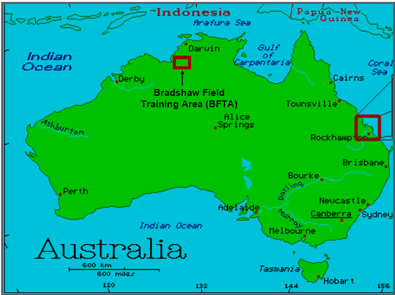
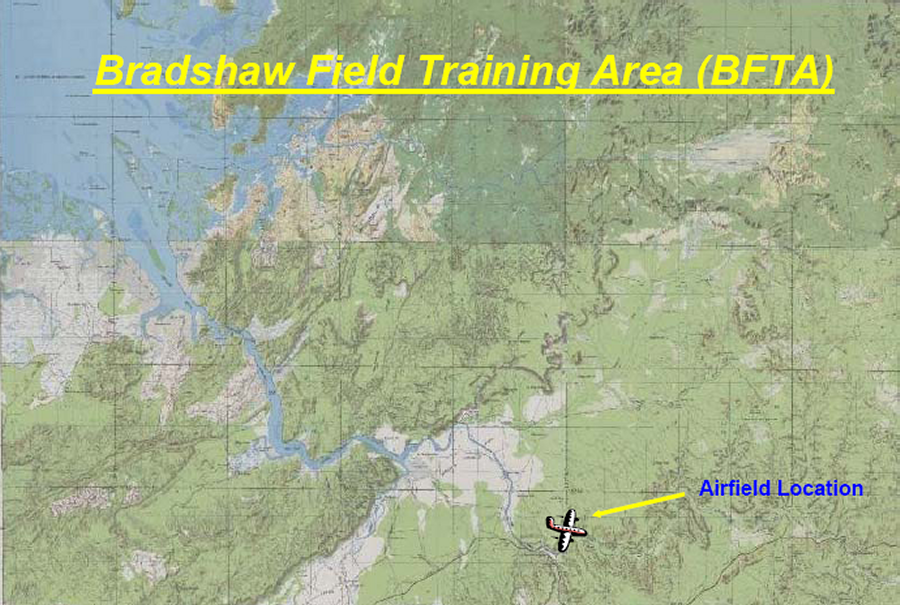
Bradshaw Airstrip
[edit on 15-7-2008 by zorgon]
Originally posted by zorgon
Anyone got anything on this one?
Bradshaw Airstrip
Nackeroo AirstripAddress:
bbs.keyhole.com
1 of 1 placemarks in ~GE9339.kmz - 2k
Nackeroo LZ was offically christened with a RAAF C-130 operation on the morning of June 23, 2007. The US Air Force certification crew gave their official blessing for C-130 ops and the Royal Australian Air Force responded with quite a show for the construction team. The airfield was proudly named after the famous North Australian Observation Unit (NAUO), nicknamed the "Nackeroos" that patrolled the Northern Territory in WWII. Based in Katherine, NT (about 250 km east of Timber Creek) and led by a former anthropologist familiar with the area, Maj. William Stanner, the Nackeroos gained quite a reputation for their toughness and dedication. Initially struggling in this harsh territory, the Nackeroos formed strong alliances and gained respect for the Aboriginal inhabitants that helped them navigate the area and survive. The cooperation and mutual respect continues today as evidenced by the cooperation that is Bradshaw Field Training Area.
Google map it just to the north of Timber Creek NT, on the river bend.
[edit on 15-7-2008 by Shar_Chi]
your good Char... thanx ..
I'll be on it in the morning
Cheers
mungo
I'll be on it in the morning
Cheers
mungo

reply to post by Zelong
you are way out of line !!!!! have you read the T & C`s. ??
i hope you are banned for such a rude and offensive comment.
snoopyuk
you are way out of line !!!!! have you read the T & C`s. ??
i hope you are banned for such a rude and offensive comment.
snoopyuk
Originally posted by snoopyuk
reply to post by Zelong
you are way out of line !!!!! have you read the T & C`s. ??
i hope you are banned for such a rude and offensive comment.
snoopyuk
This stuff is Military OUR stuff.
Originally posted by Zelong
I am Born and Breed in one of them places.
Protect ya ground and keep it!
My scrub.
EDITut my post back up!
I must be dealing with a child mod here!
Just because someone has NO IDEA of the area in question I stand for.
[edit on 12/8/08 by Zelong]
new topics
-
Erasure
Music: 1 hours ago -
The cycles of money
History: 2 hours ago -
The Three Bastards Pocast!
Member PODcasts: 3 hours ago -
so what happened to the covid quarantine camps
General Conspiracies: 3 hours ago -
Androgeneous, Bisexual, Homosexual, or Heterosexual?
ATS Skunk Works: 4 hours ago -
Trump appears to freeze for 30 seconds on stage during NRA speech
Politicians & People: 7 hours ago -
I'm At It Again With Ask AI This Time Is Creationism and Evolution Of Species Versus Scientific Theo
Conspiracies in Religions: 8 hours ago -
Satan in the open
History: 9 hours ago -
Warhammer 40000
Short Stories: 10 hours ago -
Animated short - Kingdom - In Shadow - A glimmer of hope for the downtrodden
Philosophy and Metaphysics: 11 hours ago
top topics
-
ATS lives on...
General Chit Chat: 11 hours ago, 22 flags -
Helicopter carrying Iran’s president suffers a ‘hard landing,’ state TV says without further d
Breaking Alternative News: 13 hours ago, 17 flags -
Satan in the open
History: 9 hours ago, 9 flags -
Green Irony: Massive US Lithium Source Found - In Fracking Wastewater
Global Meltdown: 12 hours ago, 6 flags -
Trump appears to freeze for 30 seconds on stage during NRA speech
Politicians & People: 7 hours ago, 5 flags -
The cycles of money
History: 2 hours ago, 3 flags -
Benny Gantz Issues Ultimatum to Netanyahu with Threat to Resign
Middle East Issues: 15 hours ago, 3 flags -
Messages of Hope - Let’s have a Shadow Celebration
Dreams & Predictions: 11 hours ago, 3 flags -
Warhammer 40000
Short Stories: 10 hours ago, 2 flags -
I'm At It Again With Ask AI This Time Is Creationism and Evolution Of Species Versus Scientific Theo
Conspiracies in Religions: 8 hours ago, 2 flags
active topics
-
Helicopter carrying Iran’s president suffers a ‘hard landing,’ state TV says without further d
Breaking Alternative News • 177 • : CriticalStinker -
The cycles of money
History • 3 • : rickymouse -
Trump appears to freeze for 30 seconds on stage during NRA speech
Politicians & People • 48 • : charlest2 -
Re-election Tactic - JOE BIDEN Hints He May Put Books in the Homes of Black People.
2024 Elections • 35 • : WeMustCare -
The BEAST System of Revelation has been awoken and has assumed control, at least since COVID.
New World Order • 20 • : Asktheanimals -
I shot JFK..
Jokes, Puns, & Pranks • 41 • : BeTheGoddess2 -
The Three Bastards Pocast!
Member PODcasts • 2 • : ScarletDarkness -
Benny Gantz Issues Ultimatum to Netanyahu with Threat to Resign
Middle East Issues • 21 • : Mike72 -
Mood Music Part VI
Music • 3235 • : lilzazz -
BIG REVEAL | Intelligence advisor says ‘catastrophic disclosure’ about UFOs may be on horizon
Aliens and UFOs • 36 • : BeyondKnowledge3