It looks like you're using an Ad Blocker.
Please white-list or disable AboveTopSecret.com in your ad-blocking tool.
Thank you.
Some features of ATS will be disabled while you continue to use an ad-blocker.

Definitive 9.11 Pentagon EVIDENCE.
page: 14share:
a reply to: WhatItIs
Meh..? I said I got it wrong. Is this like blasphemy for you?
Good on you, great drop of the ball of what one of these planes do when it does hit a building. Good cognitive dissonance on getting some answer on that bright while light as the object hit the pentagon. You look safe in your debunker. How safe do those physical foundations feel to you?
That’s not the same as “I did get it wrong”….
Meh..? I said I got it wrong. Is this like blasphemy for you?
Try and change the subject to off topic and off thread.
Good on you, great drop of the ball of what one of these planes do when it does hit a building. Good cognitive dissonance on getting some answer on that bright while light as the object hit the pentagon. You look safe in your debunker. How safe do those physical foundations feel to you?
originally posted by: kwakakev
Good on you, great drop of the ball of what one of these planes do when it does hit a building.
Really. How many threads at ATS where the WTC has been posted to death. And you can still post in those threads concerning the World Trade Center.
The topic of this thread…. “Definitive 9.11 Pentagon EVIDENCE” Which is not about the twin towers where there are already a number of WTC threads here on ATS.
This animated GIF file is from the Judicial Watch source. It includes my draft of the lens distortion tool. While the full original image did not turn out right, the part of the original image used in this GIF is looking close to having the distortions removed. The manipulations done was just based on eye and what looks right along the tree line and the region where the object comes into view..
There is still very likely some error in my analysis. I know I also have a bias and view whatever hit the Pentagon as more missile than plane from the other supporting evidence.
To really know exactly what this object was is up to the Pentagon to release. Going to need some patience on that one.
edit on 5-4-2023 by
kwakakev because: grammer
What is really strange, in Kwakakev's picture on top of page 12, is that he measured in his analysis, the plane as 35 ft long, so, 1/2 of the West
Wall's height.(77 ft, not 71 ft, btw)
I measure it in every original DoD video frame's picture (those with all the bended roof and pavement lines), as the same as the height.
Thus, 1/1. In other words, 77/77.
Kwakakev, can you explain the far too small plane length of 35 ft, if you will be so kind.?
Since I see no plane at all in his below picture, he says he took from the original DoD file, and was posted by him on top of this thread its page 12 :
files.abovetopsecret.com...
[pic]rf5f3cdbac.png[/pic ]
There is also that peculiar black dot present, which I saw in many of member neutronflux his pictures too.
The notorious 9/11 Truthers arguments hater. New member WhatItIs acts as one of his reincarnations.
If you copied one of his Google video pictures, with those black dots in them, be careful doing that again, those are notorious for clearly been posted by rabid official story defenders, who take authenticity, originality and honest researching, not seriously.
Examples :
Last picture in page 13 of your "Trying to resolve 9/11 thread".
Last picture in page 14 :
LT : those are corner columns, not core columns.
See first post on page 15 by Salander :
www.abovetopsecret.com...
And neutronflux keeps endlessly repeating his core columns drivel all over this 9/11 forum.
T&C, ATS its Terms & Conditions, where are they, when needed.?
While if he would have taken the little time necessary to measure the corner columns positions, on an hour older photos, shot at the same angle, from before 9/11, we would have been saved from his irritating to no end, re-posting from that core columns drivel by him.
Re-posting endlessly is against T&C, I always assumed.
The same wrong, re-posted endlessly, doesn't make it right, it is childish.
Member ucanthandlethetruth, here is your answer to your question :
"Who is the originator of the report I found" :
LT : Well, it always was in the top of page 2, of that 378 page long report by J. P. Heidner :
""If you wish to use copyrighted material from this report for purposes of your own that go beyond 'fair use', you must obtain permission from the copyright owner (JP Heidner).""
I posted years ago, some about 20 long posts about him, with heaps of links to many of his excellent writings, the link to that post of mine is in this thread's page 13 already.
Tip : Use ATS its build-in Search function here (on every page top's right side), fill in J.P. Heidner LaBTop. Or the other way round. Click Search. Voila. Or, click this post link :
www.abovetopsecret.com...
.
If that picture that you, Kwakakev, used on top of page 12, was correctly measured by you, it must have been one of the seemingly photo-shopped
fraudulent pictures, littered around on the Internet, or a plane measurement mistake in your photo, or, a problem originating by you.
Because the visible plane you say you see (see above) at the top of page 12, ( I don't see that) in your there posted, hopefully original DoD picture (note that bended roof line, and it's also a Google view picture with a fat black dot in it) and that you indicate as measured as 35 ft long ( 1/4th wall height), is not as long as it should be, when compared to the West Wall's known height of 77 ft, at the visible point of impact, in the original 2006 to half 2022, freely available DoD video frames.
While I see a length of ~77 ft, same as the Pentagon wall's height.
Which the readers can measure themself in mine and David Chandler's not-yet-GIMP'ed pictures, thus, the original 2006 and 2015 distorted by fat fish-eye lens DoD frame pictures, FOIA freed in 2006 from the US DoD.
Where there is indeed a plane visible, and when blinked by David Chandler, its becoming even much more obvious.
And those 2006 DoD published original security cameras video frames, as used in 2015 by David and Ken, were at the time published, thereafter during many years controlled by thousands of 9/11 researchers, including myself.
And many ATS 9/11 forum members too.
David's GIMP-site page has not changed over the last 7.5 years, by the way.
.
I'm quite sure, still working, linked copies of the original 2006 DoD security gate cameras 1 and 2 and their footage of distorted video frames, are
somewhere in these forums :
ATS videos forum, page 2 of 4 :
www.abovetopsecret.com...
9/11 and 7/7 documentaries :
www.abovetopsecret.com...
In there :
topdocumentaryfilms.com...
HUGE.! Can be Searched with the right words.
Search the Internet for the 2ND EDITION OF LOOSE CHANGE for 9/11 TRUTH.
9/11 conspiracies forum, page 1 of 188, it will require some reading :
www.abovetopsecret.com...
This FBI Records video file, posted Dec, 2 2022 by ATS member StoneColdberg, in this thread :
Title : Video (WTC) - NO video (Pentagon) - Information control :
www.abovetopsecret.com...
shows 9:17 minutes of the Pentagon scene, after impact. Quite some unknown details, for most of you, in there :
files.catbox.moe...
Found one official copy, of both DoD cameras :
www.abovetopsecret.com...
ATS member nerbot : "For reference, clip of official AP (Associated Press) provided evidence" :
youtu.be...
At the 4 seconds point, into this above original 2006 DoD video, AA77 is visible above the camera-2 pedestal, the West Wall its bended roof shape is shown to the left, the plane is the same height as at the impact point in the Wall, its known height of 77 ft :
youtu.be...
At the 91 seconds point, at 1:31 / 2:56 --click the "K" key on your keyboard, to stop the video, or let it go--, the plane and its white smoke trail, is in unhindered sight from camera-2, located against the security shed its front wall, the plane at the far right in the original frame :
youtu.be...
Length of measured plane is the same as the height of the West Wall at impact point.
As all copies of the original version of the 2006 DoD security cameras footage frames should show.
Another source, CNN :
cnn.com www.cnn.com... › 2006 › US·
16 May 2006 — The Justice Department has handed over tapes showing American Airlines Flight 77 striking the building outside Washington to Judicial Watch.
Another, NBC : www.nbcnews.com...
Last line : --the videos were released on the Pentagon's web site.
The real, 2 original DoD videos :
YouTube : Pentagon 9/11 Plane Crash Video 1 (0:42 minute) :
www.youtube.com...
YouTube : Pentagon 9/11 Plane Crash Video 2 (1:53 minutes) :
www.youtube.com...
No pedestal camera in view, unobstructed version.
This below video frame height, differs ~ -10 % from the above Video 1.!
YouTube : 9/11 Pentagon Attack Video Gate Camera 2 (3:22 minutes) :
www.youtube.com...
.
So, we have in fact, at this time of my posting, just one picture posted by Kwakakev on top of this thread's page 12, with an, clearly incorrect
analyzed by him, length of 35 feet, in red letters written in his picture.
And measured height of the Pentagon's West Wall is not 71 ft, but 77 ft.
While I have shown my measured length of 77 ft, from several reliable video sources, for instance in the by David Chandler blinked frames, that results in a much better visible AA77 Boeing 757 length.
Compared to AA77's well known length of 155 ft, it's resulting in half of that 155 ft, thus 77 ft, which is also the known height of the Pentagon's West Wall, at its also known impact point at column 14.
In the original 2006 versions of these sources their copies ( so, not GIMP'ed yet ! ). When then GIMP'ed, that 77 ft measured plane length turned out to stretch to its real 154 ft when GIMP'ed, thus when its bended lines and dimensions were horizontally stretched out.
In my opinion, we have lost precious days left for me, based on a sloppy analysis.
Let's get over it, and proceed to indicate the most probable, guilty planners for 9/11 .
Because if you keep neglecting the immense monstrosity executed by such a small group of influential planners, on and around 9/11/2001, their next plans will be every time more evil, until it will affect you all, and your offspring.
.
edit on 5/4/23 by LaBTop because: one [/i ] instead of [/u ]
edit on 5/4/23 by LaBTop because: have to insert a space between
[.. ]
Your remark about the bright white flash at the moment of impact of AA77, which you see not at the two WTC impacts, will have been the result of the
difference between a relatively massive thick stone Pentagon wall with small windows and decked with a layer of marble plates, recently renewed, and
a glass decked open frame between relatively thin WTC floors.
At the WTC, the planes their super heated by the impact, tiny aluminum pieces of the fuselage and their wings and inner hull, splattered by the impacts forces, on top of that loaded with their splattered fuel tanks its J6 jet fuel, were mainly shot into and in between the open space between the thin WTC upper floors and exploded for the most part thus inside the buildings, while thereafter the last part of the exploded fuel plus aluminum, spit partly backwards out again, caused by the immediate pressure increase in front of the momentarily locked up burning gases, and that was the first and second fuel/air explosive parts we saw at 260 m and 220 m up there, so from a view at the lower part of that ricocheted reddish explosion cloud, with just a touch of white inside it.
While at the Pentagon, the first main bulk of the J6 fuel plus the super heated exploding aluminum parts cloud in it, exploded against the relatively more massive bricks wall segment, with their strong, re-barred window frames, and only after that, in the following split second, the wall was gone and it all started to enter the reasonable empty space behind that wall.
.
I usually see meaningful and useful patterns in the data published in the many combined publications I studied during many decades, where no one else
could deduct these patterns, as far as I could found out, in most cases.
It is quite difficult to try to explain to others, how I arrive at the point where I suddenly see such patterns.
However, in the case of Flight AA77, while it was in its last 110 meters attacking the Pentagon's West Wall on 9/11/2001, I at first thought it was a piece of cake to explain its now, at last, clearly and easily deductible, 90 degree to the West Wall attack flight path, with the assistance of David Chandler and his use of blinking video frames and the GIMP software package, to the recent ATS crowd.
While AA77 was being recorded by two DoD security gate cameras, equipped with fat fish-eye lenses, that however delivered quite dimensional distorted, but wide area, video footage. Of a Boeing 757 passenger plane, extremely low flying over the Pentagon lawn.
That footage was FOIA freed at last in 2006 by Mr Erik Larson via the by the FBI held and copied by them, security camera video footage from the DoD.
Probably the deciders at the US DoD really thought that that footage clearly showed the right dimensions for a 45 degrees incoming recorded plane, and thus the DoD also decided to FOIA publish the 9/11 footage in 2006, after 5 years keeping that DoD footage away from the public, just as the FBI did, since after 5 years they must have thought that it only would strengthen their false flag operations at the Pentagon on 9/11.
No one there thought in 2006 in advance, of newly becoming available software, like GIMP, in 2015, nine years later.
But they counted on original distorted DoD video footage pictures like this below one, analyzed for the barely visible plane's length dimension, by ATS member Kwakatev, probably also thinking at that time, that those were the real dimensions he measured at that time, and posted now on top of this thread's page 12 :
files.abovetopsecret.com...
[img]https://files.abovetopsecret.com/files/img/rf5f3cdbac.png[/img ]
The bended roof-line and pavement could have had him think it over, a tad bit more then.
He certainly could not know by then, that especially in the far sides and corners of such, by fish-eye lens shot footage, such strongly distorted pictures are resulting, like his above one. Resulting in up to 2 times smaller horizontal dimensions there. Plane length compared to the Pentagon Wall's height ( ~ 77 ft) is 2 x smaller in the original fish-eye lens video frame, than the GIMP'ed real plane length ( ~ 154 ft) .
The same picture, but now correctly corrected by GIMP's software, to the real everyday dimensions, looks however quite different, with straight lines now inside the resulting "pin-cushioning" distortion (inward bowing) that cancels the barrel distortion, as David Chandler explains, like this :
911speakout.org...
[url=]http://911speakout.org/wp-content/uploads/BarrelFix-Cam2-no-plane.png[/url ]
[img]http://911speakout.org/wp-content/uploads/BarrelFix-Cam2-no-plane.png[/img ]
Zooming in via your OS its zoom function, at the right side results in seeing the real plane length of 155 ft, which is now at last visible as it should naturally be, and also easily measurable, as nearly exactly two times the height of the West Wall at its column 14 point of impact :
2 x 77 = 154 ft.
And thus not the 35 ft virtual plane length that Kwakatev measured in his old fish-eye lens footage frame analysis (turns out to be 38.5 ft, so he was close), which is half of the West Wall's well known height of 77 ft (btw, not 71 ft, as in his analysis picture, perhaps he thought that he had to subtract the building's shadow stretch off ? I did that too, and still the GIMP'ed version showed 77 ft) .
Thus. the DoD fish-eye lenses minimized the real dimensions of a recorded Boeing 757 passenger plane in the extreme 4 corners and 4 top-and-bottom sides of its footage, to a FOURTH of its real-world length.
This clearly shows the enormous distortion strength of the fat fish-eye lens in each of the two DoD's operating cameras, compared to a normal lens packet as should have been used instead, to produce real-time footage by these two DoD cameras. Like the below GIMP'ed, straight lines producing, real world reproduced GIMP partial picture.
So this is my 500 times zoomed in, right top part of the above GIMP'ed picture, as is quite obvious when you see the slightly "sliced and cut-out" lower right portion of it, as part of the huge GIMP-effect :
[pic]ct6390d458.png[/pic ]
.
And then in 2015, the commercially available GIMP software package, bought by David Chandler, (the man who also found, as the first ever 9/11
researcher, the 2.5 seconds of real free fall acceleration, worth 8 stories height in WTC-7, during the collapse of Building Seven in the late
afternoon of 9/11/2001) , that GIMP package then easily provided for the first time ever, a correction to the two, by fish-eye lens enormously
distorted, DoD security gate's video's footage's frames, restoring them back to their real-world dimensional two GIMP'ed footage, and its corrected
result is then directly to be seen, also via my second cut-off picture in my opening post, in this "Definitive 9.11 Pentagon EVIDENCE" thread.
See that identical full picture, as my above posted last of the three pictures I just posted, with my thinly red, real dimensions showing lines, drawn in it. Its plane length looks smaller than it really is.
Measure it with a ruler, it really is exactly two times the West Wall's height at the impact point, at column 14 in its facade, and the 3 stories high tree in front of that column.
That picture shows the real AA77 length of 155 ft, compared to the also to be seen real height of the West Wall, of 77 ft, measurable at Flight AA77 its final impact point at column 14 in that Pentagon's West Wall.
To avoid all my cut-off posted pictures, not fitting in the ATS posting windows, in the first 2 pages of this thread, just click in all those posted thread pictures, use the then opening, small roll-down menu, click "Open in new tab", so you see at last an, as meant by me, full ATS window-fitting picture.
It did fit at the time in the ATS posting window, in the Preview of the post also, but came out cut-off, when quickly posted -thus not checked- on 10 Dec 2022 by me. Checked only, after some badly needed sleep time, after my post-edit time was already earlier, long timed out.
.
I however see now, that I misjudged the willingness of this recent ATS public at this moment in time, to READ and comprehend my offered flight AA77
Pentagon 90 degrees attack evidence with all its links to additional supporting facts and methods.
In fact, AT LAST, the ultimate, undeniable EVIDENCE, that all of 9/11/2001 was an enormous FALSE FLAG Operation.
By whom exactly, that's the next job; Mark Gorton, Sterling and Peggy Seagrave, especially David Guyatt described a good part of it, and J.P. Heidner molded most of the big picture already in his superb "The 9/11 Commission Report, a newly revised version".
This EVIDENCE thread of mine, its only 14 pages now.
First, just click every one of my images, first in page 1 and use then the small roll down menu in every image, to be able to see all the full images, in the format as I intended to post them. As I noted already in my last post at the bottom of page 11 of my thread.
.
The 2 original DoD security gate videos, recorded on 9/11/2001 at the Pentagon's Northern Parking gate, are stored and were available from 2006 on, in
the Library of Congress, where all historical important US artifacts are saved. And the FBI has copies too, David Chandler laid it out for you on a
platter. Larson did get them via FOIA from the FBI in 2010 :
www.scribd.com...
All in the first lines on David's site :
911speakout.org...
David shows a zoomed and cropped GIMP corrected view from Camera 2, with real world dimensions, however, no known length objects, to compare with :
911speakout.org...
[img]http://911speakout.org/wp-content/uploads/BarrelFix-Cam2-plane-cropped.png[/img ]
Which caused David to not notice what I did see, since David sadly did not include the West Wall portion to the left side, with its well known height, which I instinctively did immediately, when I zoomed in at the upper right portion of his GIMP'ed, thus now barrel-distortion fixed, camera 2 picture.
And that's why I saw that when AA77 length is being GIMP'ed, it's length is shown in real dimensions, as two times more then the known West Wall's height of 77 ft at the visible point of impact, thus in fact its real plane length of 155 ft.
Thus FOUR times more then what we all saw since 2006...in the original DoD footage video frames. There were 28 frames per second.!
When you see the original fish-eye recorded footage of a visible plane in David Chandler's "View that blinks the full image from Camera 2", with all its bended roof and pavement lines, and use a pair of scissors for meauring, you'll find a plane length that's 38.5 ft, nearly exactly ( +/- tiny measurement faults) half the 77 ft known height of the West Wall at its impact point, for a recorded plane thus, that we know is 155 ft long in reality.
A 45 degree attack would thus show a plane length of 103 ft (see my recent CORRECTION post), and this one, that shows a 77 ft length, thus would seem to indicate an even sharper attack angle of perhaps near 30 degrees. All caused by the huge deformation of the installed fish-eye lens in the two DoD security cameras.
Intentionally those lenses were part of the 9/11 false flag operation, I strongly suspect. Since the security was intended to see passing/stopping drivers, passengers, cars and number plates, as clear as possible, not an unnecessary extended wide and deep lawn view.
But the 9/11-Planners reckoned that its distorted 9/11-footage would put every investigation of the on 9/11 produced fish-eye lenses footage, on the wrong foot, and it indeed did, till GIMP's software package arrived, 9 years later.
And David Chandler and Ken Jenkings, who used it adequately, to stretch all bended roof and pavement lines to normal, straight ones, as a normal multi-lens pack would have done directly, if it would have been installed.
When you then measure AA77's, corrected by GIMP, visible length, in David's "canceled barrel distortion of Camera 2" picture, its length is suddenly nearly exactly two times longer then the 77 ft well known height of the West Wall, at its impact point, showing then AA77's real length of 155 feet.
.
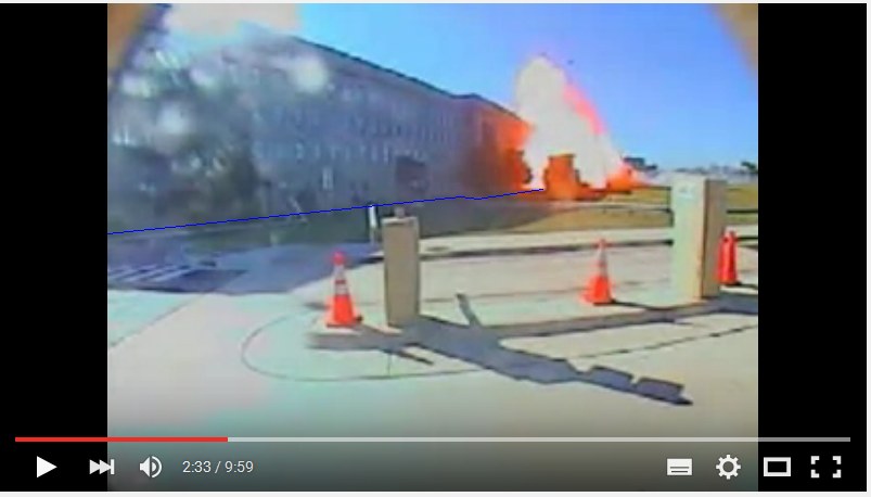
That impact point is situated just behind that bulky brown spot that you see in front of the West Wall, which is the Landing pad its Control Tower.
That Control Tower you see very clear in my posted photo of the moment of impact by AA77, when it sticks out clearly against the white/reddish
explosion of the JP-6 jet fuel, annex compressed flashing super-heated aluminum cloud from an impact at more than 265 MPH, but surely not at ~ 810
Km/hr or ~ 542 MPH (note the blue facade-shadow line, the Heli-pad's Control Tower, and, the original 2006 DoD's frame recorded bended roof line) :
files.abovetopsecret.com...
[pic]dy56280a0b.PNG[/pic ]
To better situate the exact point of impact by AA77, you can use the following 2 links, to the same alternating animated GIF picture of the impact explosion cloud, and the same quiet scene, also placed on top of both page 2 and page 8, in Dec. 2022, by me :
[img]https://files.abovetopsecret.com/files/img/mj59005b07.gif[/img ]
Change [/img ] back to [/img] , then you'll see the animated GIFs on your PC, Tablet or hand-phone, perhaps here now too :
[pic]mj59005b07.gif[/pic ]
Just replace the last " ]" sign backwards, to get the completed [/pic] sign back again, so you can open the corrected file address line in your OS, in case you do not see an animated GIF scene with a huge white/reddish explosion cloud, while alternating with a calm open scene without that cloud :
[pic]mj59005b07.gif[/pic ]
The point of impact of AA77 on the Pentagon's West Wall was about 20-30 meters South of that Control Tower, about 8 windows to the North (left) of the southern (right) corner of the long extending part of that West Wall. AA77 impacted on the West Wall its column 14, behind that high green tree there, which was obliterated at impact.
Suggestion for a skilled Podcaster and/or YouTube filmer, or Website owner :
Construct a circa 1 to 2 meter/yard wide Diorama of the scene as seen in one of the above camera 1 or 2 video frame pictures, made of scissor-cut outs from cardboard pieces, paint them and then glue them on the bottom cardboard.
That way modelling with a scissor and some paint, that West Wall and adjacent small road, the front pavement, the white painted helicopter landing pad, the pad's Control Tower, the Security shed, the 2 camera stands, the stop-sign box-lights, that long guard rail on the lawn, the grassy lawn and the far background trees and bushes.
Modeled from the f.ex. above CAM 1 and 2 picture frames, which were registered with the two DoD cameras, with in them their installed fat fish-eye lens, delivering their resulting distorted video footage frames, shot at 28 frames per second. Use for details, your OS its zoom function.
There are many more and better detailed frame pictures from the overall Pentagon lawn details, all over this thread, and in many many other threads in this forum, and spread all over the whole world wide Web.
Try first David Chandler's page "Blinked Views of Pentagon Plane" :
911speakout.org...
and also his GIMP'ed barrel distortion of Camera 1 and 2.
Attach a strong lamp high and far behind the cardboard's modeled Pentagon's West Wall's roof-line, in a position that the lamp's light, just as the morning sun on 9/11, formed the same shadows on the Diorama's ground plate, as in the above camera video frame.
Then place a digital camera ~ 1 meter in front of the Diorama, hang a model plane of a B757 low over the scene in a 90 degree attack position, make one camera shot.
Then move the B757 to a 45 degree position at the same height above the scene, with its nose at the same position as the first shot of 90 degrees, and then make your next camera shot.
move the B575 after that at will and let the camera make shots too.
And whatever more comes to your mind, be creative.
.
[pic]ma63b1b962.jpg[/pic ]
Restore [/pic ] to [/pic] in a new OS-tab and click its address line, if you want to see the original picture, where you can zoom it at will via the menu, to view much better, any details :
See this same above picture on page 9.
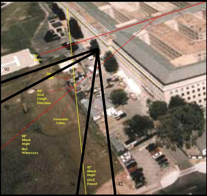
Do you, the reader, now at last comprehend, the utterly stupidity of the Officially pushed AA77 attack flight path of between 42 and 56 degrees towards that Pentagon's West wall.?
Huge chunks of it would have been already lost inside the construction lot, by hitting the long part of its fence, the various construction trailers, trees, work buses, heavy equipment and ev. persons working and walking there. Most parts of its fuselage would have ricocheted off the West Wall, caused by the too small angle of attack. Let's not even start with the wings and tail.
And please, stop rehearsing that stupid end-speed of ~ 810 Km/hr, via Mr Stutte (Australia), David Chandler's later friend, while ALL official radar data given by US radar sources, stopped at a point just ~ 30 to 50 m south of the Sheraton Hotel.
ALL other data they received after that point is declared by ALL these radar sources as received as not discernible garbled-up radar data streams.
Could be caused by AA77's slightly left turning over the line of the 8 Navy Annex buildings, and then diving down roughly along the steep hill side there, just ~ 100 m behind that point.
Or, since nowadays knowing for sure, this thread's 90 degrees flight path EVIDENCE, which is btw, indirectly clearly proving, that the official lie of an ~ 45 degree incoming Boeing 757, Flight AA77 huge passenger plane, which as they showed then, clipped (now proven NOT) the top of 5 light-poles in that non-existing flight path, we can conclude now as follows :
Since all main radar dishes were owned and/or operated that day by military personnel, and a few Planners in the Military High Command chain must have been deeply involved in the now proven 9/11 false flag operation, who had another lower some-one in their tight circle ordered to do that garbling-up later on, after first ordering that all the 9/11 radar data had to be send higher up, in a "save" place, as crucial evidence for the 9/11 National Security Event and any of its inevitable later on investigations.
There, in that "save" place, the inevitable 9/11 radar data Cover-Up began.
Because the plane operator had to intervene and decide in a split second what to do, when that, too high for the plane's momentarily altitude, Police Station radio mast appeared.
Deviating to the right would have wrecked the whole false flag 9/11 operation, since then column 14 would have been impossible to be reached.
So, the plane was steered slightly to the left over the Navy Annex, flew downwards around the North side of the CITGO gas station, passed over Washington Boulevard just right of (or over) the two trees which then stood aside that road, and then full throttled dove to column 14 in the Pentagon's West Wall.
Those last few 100 meters could have been executed with the help of some early Military or NSA/CIA Artificial Intelligence system, to achieve such a precision in smashing the plane's nose and its longest and strongest aluminum longitudinal fuselage beam inside that nose, exactly into the first floor's re-barred concrete floor-slab there, and at the same time into column 14.
Could have also been a somewhat easier to achieve at that time, UV, IR or radio orientation beam, placed in that three stories high pine tree, that grew in front of column 14, which column stood right inside the Pentagon's West Wall facade.
.
Restore [/pic ] to [/pic] in a new OS-tab and click its address line, if you want to see the original picture, where you can zoom it at will via the menu, to view much better, any details :
See this same above picture on page 9.
Do you, the reader, now at last comprehend, the utterly stupidity of the Officially pushed AA77 attack flight path of between 42 and 56 degrees towards that Pentagon's West wall.?
Huge chunks of it would have been already lost inside the construction lot, by hitting the long part of its fence, the various construction trailers, trees, work buses, heavy equipment and ev. persons working and walking there. Most parts of its fuselage would have ricocheted off the West Wall, caused by the too small angle of attack. Let's not even start with the wings and tail.
And please, stop rehearsing that stupid end-speed of ~ 810 Km/hr, via Mr Stutte (Australia), David Chandler's later friend, while ALL official radar data given by US radar sources, stopped at a point just ~ 30 to 50 m south of the Sheraton Hotel.
ALL other data they received after that point is declared by ALL these radar sources as received as not discernible garbled-up radar data streams.
Could be caused by AA77's slightly left turning over the line of the 8 Navy Annex buildings, and then diving down roughly along the steep hill side there, just ~ 100 m behind that point.
Or, since nowadays knowing for sure, this thread's 90 degrees flight path EVIDENCE, which is btw, indirectly clearly proving, that the official lie of an ~ 45 degree incoming Boeing 757, Flight AA77 huge passenger plane, which as they showed then, clipped (now proven NOT) the top of 5 light-poles in that non-existing flight path, we can conclude now as follows :
Since all main radar dishes were owned and/or operated that day by military personnel, and a few Planners in the Military High Command chain must have been deeply involved in the now proven 9/11 false flag operation, who had another lower some-one in their tight circle ordered to do that garbling-up later on, after first ordering that all the 9/11 radar data had to be send higher up, in a "save" place, as crucial evidence for the 9/11 National Security Event and any of its inevitable later on investigations.
There, in that "save" place, the inevitable 9/11 radar data Cover-Up began.
Because the plane operator had to intervene and decide in a split second what to do, when that, too high for the plane's momentarily altitude, Police Station radio mast appeared.
Deviating to the right would have wrecked the whole false flag 9/11 operation, since then column 14 would have been impossible to be reached.
So, the plane was steered slightly to the left over the Navy Annex, flew downwards around the North side of the CITGO gas station, passed over Washington Boulevard just right of (or over) the two trees which then stood aside that road, and then full throttled dove to column 14 in the Pentagon's West Wall.
Those last few 100 meters could have been executed with the help of some early Military or NSA/CIA Artificial Intelligence system, to achieve such a precision in smashing the plane's nose and its longest and strongest aluminum longitudinal fuselage beam inside that nose, exactly into the first floor's re-barred concrete floor-slab there, and at the same time into column 14.
Could have also been a somewhat easier to achieve at that time, UV, IR or radio orientation beam, placed in that three stories high pine tree, that grew in front of column 14, which column stood right inside the Pentagon's West Wall facade.
.
new topics
-
Russia police launch major manhunt after troops massacred by comrade in occupied Ukraine
Other Current Events: 2 hours ago -
Chinese scientists create new mutant Ebola strain with horror eye symptoms
Breaking Alternative News: 3 hours ago -
Maclemore - Hind's Hall (Pro-Palestine protest song)
Music: 3 hours ago -
Social Security projected to cut benefits in 2035 barring a fix
Global Meltdown: 5 hours ago -
Trump supporters training in the HILLS!!!!
US Political Madness: 6 hours ago -
Is the move to greenwashing solar and wind power set up for money laundering.
The Gray Area: 6 hours ago -
LIVE: Putin inauguration ceremony
Regional Politics: 8 hours ago -
Black kids in the Bronx don't know what the word 'computer' is
People: 10 hours ago
top topics
-
Trump supporters training in the HILLS!!!!
US Political Madness: 6 hours ago, 14 flags -
Black kids in the Bronx don't know what the word 'computer' is
People: 10 hours ago, 8 flags -
This is what it is all about
US Political Madness: 12 hours ago, 7 flags -
Chinese scientists create new mutant Ebola strain with horror eye symptoms
Breaking Alternative News: 3 hours ago, 5 flags -
Social Security projected to cut benefits in 2035 barring a fix
Global Meltdown: 5 hours ago, 4 flags -
Russia police launch major manhunt after troops massacred by comrade in occupied Ukraine
Other Current Events: 2 hours ago, 4 flags -
LIVE: Putin inauguration ceremony
Regional Politics: 8 hours ago, 3 flags -
Is the move to greenwashing solar and wind power set up for money laundering.
The Gray Area: 6 hours ago, 2 flags -
Aliens and Las Vegas
Aliens and UFOs: 12 hours ago, 1 flags -
Maclemore - Hind's Hall (Pro-Palestine protest song)
Music: 3 hours ago, 0 flags
active topics
-
Candidate TRUMP Now Has Crazy Judge JUAN MERCHAN After Him - The Stormy Daniels Hush-Money Case.
Political Conspiracies • 1362 • : Justoneman -
The Acronym Game .. Pt.3
General Chit Chat • 7809 • : F2d5thCavv2 -
Trump supporters training in the HILLS!!!!
US Political Madness • 49 • : RazorV66 -
Israeli strikes on southern Gaza city of Rafah kill 22, mostly children, as US advances aid package
Middle East Issues • 163 • : ToneD -
Breaking--Hamas Accepts New Cease Fire
Middle East Issues • 228 • : KrustyKrab -
Is the move to greenwashing solar and wind power set up for money laundering.
The Gray Area • 6 • : TimBurr -
-@TH3WH17ERABB17- -Q- ---TIME TO SHOW THE WORLD--- -Part- --44--
Dissecting Disinformation • 851 • : fringeofthefringe -
The Reactionary Conspiracy 13. The plot’s theology.
General Conspiracies • 169 • : Ohanka -
Russia police launch major manhunt after troops massacred by comrade in occupied Ukraine
Other Current Events • 9 • : grey580 -
The Dark Pyramid of Alaska and the Why Files take on the subject
Whistle Blowers and Leaked Documents • 26 • : SprocketUK