It looks like you're using an Ad Blocker.
Please white-list or disable AboveTopSecret.com in your ad-blocking tool.
Thank you.
Some features of ATS will be disabled while you continue to use an ad-blocker.

Old Area 51 news or new find?
page: 114
share:
I stumbled upon this video of supposed secret entrances into the mountains near Area 51.
It shows tunnels found near Area 51 that go into a mountain near the famous site. It's pretty convincing that these are entrances of some sort for vehicles driving on the ground. Two of the entrances are 1.6 miles apart. Perhaps they connect, perhaps not. Perhaps it is just a mile and half long tunnel through the terrain.
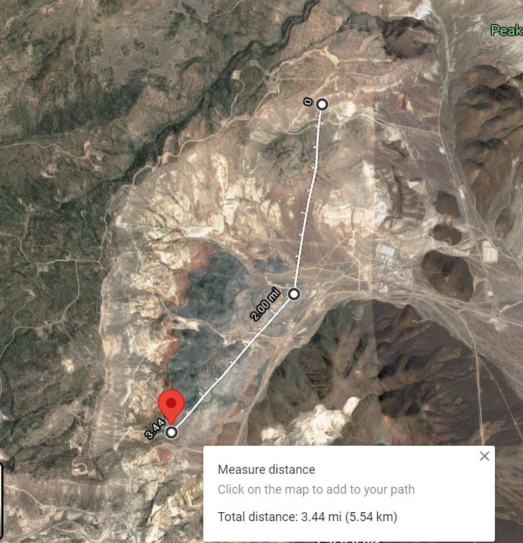
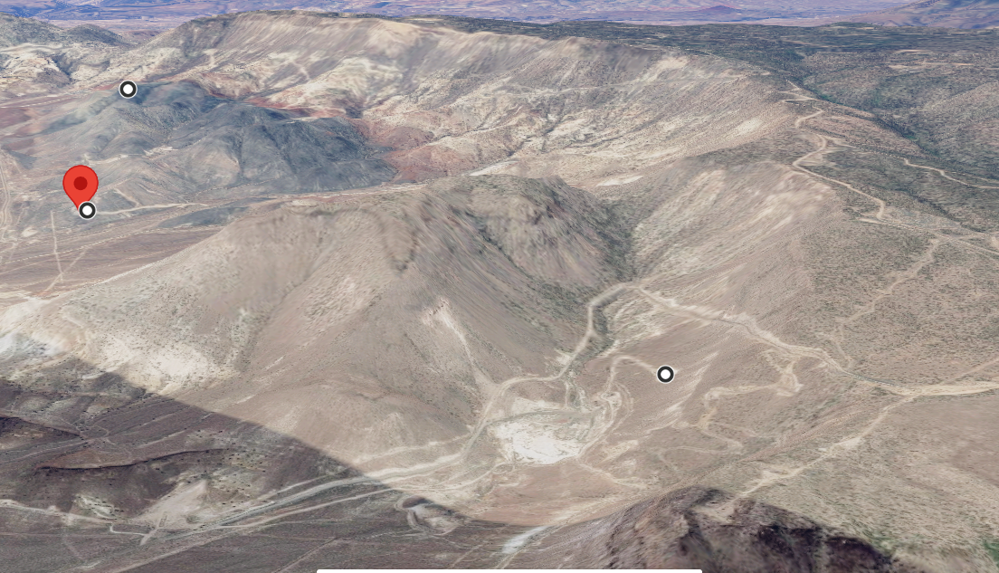
I decided to follow the roads in the area and came upon this feature. Coordinates: 37.216466, -116.169327
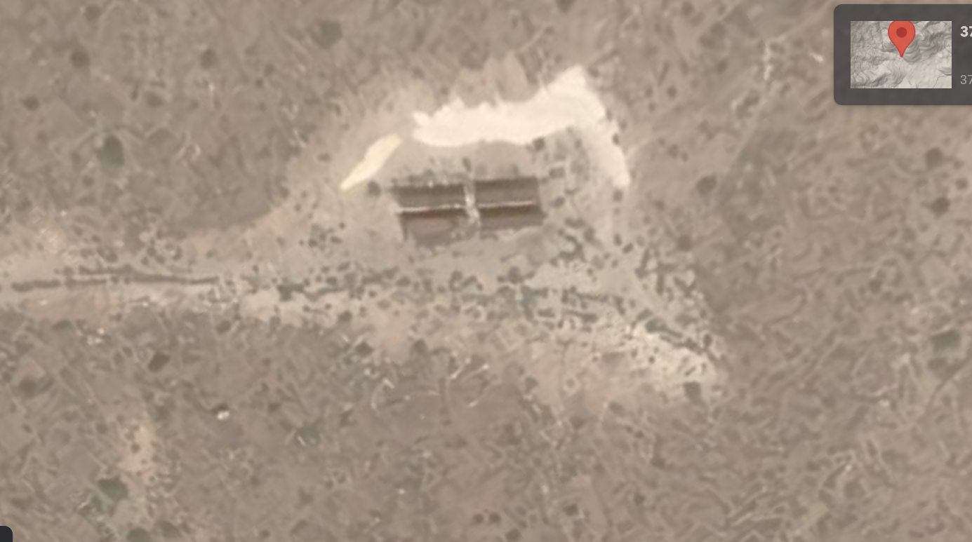
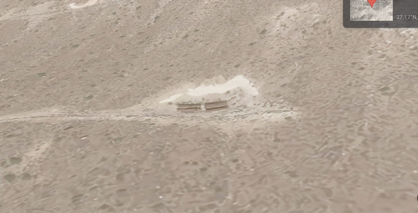
Unless I'm mistaken, this pretty definitively is four openings in the hillside, each approximately 40 feet wide. What really excites me is that they are stacked, which means the upper level openings cannot just be driven into like the ones from the video. They are not just a tunnel through the terrain, they are designed in a way where their only purpose would seemingly be for a craft to fly into. What sort of craft is anyone's guess, but it seems like an awfully secretive and dangerous way to land any craft I know of.
The three sites are almost three and half miles from end to end and run along a ridge line.
Old or new, I think it's pretty intriguing.
It shows tunnels found near Area 51 that go into a mountain near the famous site. It's pretty convincing that these are entrances of some sort for vehicles driving on the ground. Two of the entrances are 1.6 miles apart. Perhaps they connect, perhaps not. Perhaps it is just a mile and half long tunnel through the terrain.
I decided to follow the roads in the area and came upon this feature. Coordinates: 37.216466, -116.169327
Unless I'm mistaken, this pretty definitively is four openings in the hillside, each approximately 40 feet wide. What really excites me is that they are stacked, which means the upper level openings cannot just be driven into like the ones from the video. They are not just a tunnel through the terrain, they are designed in a way where their only purpose would seemingly be for a craft to fly into. What sort of craft is anyone's guess, but it seems like an awfully secretive and dangerous way to land any craft I know of.
The three sites are almost three and half miles from end to end and run along a ridge line.
Old or new, I think it's pretty intriguing.
edit on 6/15/2022 by scojak because: (no reason given)
It's been a long time since any real new information has been presented about Area 51; thanks for posting!
Going to watch the video now.
Going to watch the video now.
a reply to: scojak
I have a hard time seeing any known craft land in there indeed, but there is another option.. lauch a couple of them, from in there... The surroundings would allow it, and there are some susspicious spots along and imaginary underground starting strip.
Nice find.
their only purpose would seemingly be for a craft to fly into.
I have a hard time seeing any known craft land in there indeed, but there is another option.. lauch a couple of them, from in there... The surroundings would allow it, and there are some susspicious spots along and imaginary underground starting strip.
Nice find.
a reply to: scojak
I have visited that area on several occasions. It is the Area 12 tunnel complex at Rainier Mesa on the Nevada National Security Site (formerly the Nevada Test Site). These tunnels were used for underground testing of nuclear explosive devices. They have nothing to do with Area 51.
There is a lot of good information available online about the history of these sites.
a reply to: Shadowhawk
That's just what they want you to think
Thanks for the clarification. Seems like a massive complex!
That's just what they want you to think
Thanks for the clarification. Seems like a massive complex!
SPAM
edit on 6/16/2022 by semperfortis because: (no reason given)
a reply to: scojak
The tunnels were designed to contain nuclear explosions and provide spaces for special instrumentation to analyze the various physical characteristics of each detonation. All of this was necessary after the ban on atmospheric testing of nuclear weapons went into effect. Nuclear weapon scientists were challenged to find new ways to measure shock effects, radiation, explosive yield, etc., while preventing any nuclear fallout from escaping. Stemming the drill holes and tunnels with fast-closing doors, concrete plugs, gravel, and other materials was mostly effective.
Sometimes, however, these measures failed or there was some unexpected geological characteristics at the test location, and radioactive material was accidentally released through a process called dynamic venting. Google the term "Baneberry" for a good example. Even placing a device deep inside a tunnel within a rocky mesa was not a guarantee of containment. In 1984, the Midas Myth/Milagro shot inside Rainier Mesa in Area 12 caused a chimney effect that eventually reached the surface several hours after the event, while test technicians were inside equipment trailers at surface ground zero (several hundred feet above the shot chamber). While they were there, the column of rock above the shot point collapsed, dropping the trailers into a 15-foot-deep, 300-foot-wide crater. One person died and 15 were injured. In addition, the emplacement tunnel collapsed to a greater extent than expected, causing damage to some of the experimental equipment. No radiation release occurred, and there was no personnel radiation exposure.
a reply to: scojak
A long response I am afraid.
The original "rectangles" you found are the remains of "Nissan Shelter" type buildings, with semicircular (or near enough) profile roofing.
The roofs have gone, leaving the rectangular walls.
To see what the original buildings looked like, complete with roofs, use google mapping (either via maps or google earth) and even Bing. Roll back the time-line. You will then see historical satellite imaging of the buildings complete with roofs.
To see what else is, or rather was, in the area, use wikimapia.
Importantly, wikimapia has been sanitizing its databases. A lot of the information has been removed. This "sanitizing" started happening at the same time as Russia moved into Ukraine. The Wikimapia went offline with a message saying BackSoon. They didn't offer an explanation - at least not that I am aware of. But is back on-line now, a mere shadow of its former self.
Instead, you should use old.wikimapia.org. This uses the older databases. You can see the older tunnel groups on the map. Put in the coordinates you originally posted into old.wikimapia.org
Access to old.wikimapia.org is said to be time limited. The owners say it will be taken off-line, but haven't specified exactly when.
You can compare the databases by entering the coordinates into wikimapia.org and comparing to the results from old.wikimapia.org - there are substantial differences.
If you are interested in holes-in-the ground, in the area around your coordinates, old.wikimapia shows some of the tunnels used in the past, tunnel complexes such as B, E, G, N, I, J, K, P, T.
There are online forums where you are able to download kml / kmz files to import to google earth. The files show many of the features of groom lake and the Old Nevada Test Site. There are a great many inaccuracies, as there are in wikimapia.
There are many obvious tunnels still being used - many for sub-critical testing, where things are made to go with a "fizz", small "pop", but not with a big "bang". There are many of these tunnels / facilities outside of the direct area you originally posted. You need look further afield
For a more modern idea of later tunneling, do a duckduck search for "tunnel boring machine area 51", "tunnel boring machine nevada test site" etc. You should come across contractors who have used these machines recently (within the past 10 years or so - !hint or less). They wont tell you what or where they tunneled, but will give an idea of the level of activity.
Many of the early tests used bore holes and not tunnels, along with some limited testing on the surface. The tunnels were also used for the early "decoupling" experiments - essentially reducing the "bang" from the things that went "bang", thereby disguising the fact that something underground went bang. A huge bang can be made to look like a smaller "Pop". Look it up, you will see what I am referring to.
As well as the mapping services that 'adjust' what is on public displayed, there are many tunnels and other facilities that are well disguised physically. There are other global players interested in what is going on. What you are able to view on the modern satellite views are either historical data, or infrastructure that is deemed not financially cost-effective to hide. I mean, if you can hide something in a building, why spend millions constructing a disguised tunnel or other facility.
If you know where to look, you can see evidence of highly disuised and camouflaged facilities. Even when you know exactly where to look, it is difficult to make them out (and I am not referring to S4 :-) ) What you see is what they allow you to see.
There are a lot of official historical data about the past tests and tunneling in the area. Many of these original scanned documents are disappearing off the internet - after all, in internet terms, these are ancient documents.
Use archive.org which still has thousands of scans of original documents available. It will be a huge amount of data, you will need to be creative in your search terms to filter the documents that interest you.
And did I mention the mines? The area has many many old mines and old underground workings. These are poorly documented and it is difficult to find accurate and exact information. It is almost as if someone somewhere doesn't want you to know!
GP
a reply to: GrumpyPants
Wow! Great information!
I do agree they likely scrub any images that are sensitive.
And though it seems I was completely wrong about what I was looking at, I've gained a wealth of additional knowledge, so thank you for that.
Wow! Great information!
I do agree they likely scrub any images that are sensitive.
And though it seems I was completely wrong about what I was looking at, I've gained a wealth of additional knowledge, so thank you for that.
new topics
-
4/27/24 New Jersey Earthquake
Fragile Earth: 4 hours ago -
Fun with extreme paints
Interesting Websites: 5 hours ago -
CIA is alleged to be operat social media troll frms in Kyiv
ATS Skunk Works: 6 hours ago -
Rainbow : Stargazer
Music: 7 hours ago -
I sleep no more.
Philosophy and Metaphysics: 9 hours ago -
Canada caught red-handed manipulating live weather data and make it warmer
Fragile Earth: 10 hours ago -
Why Files Our Alien Overlords | How We Secretly Serve The Tall Whites
Aliens and UFOs: 11 hours ago
top topics
-
Canada caught red-handed manipulating live weather data and make it warmer
Fragile Earth: 10 hours ago, 16 flags -
Why Files Our Alien Overlords | How We Secretly Serve The Tall Whites
Aliens and UFOs: 11 hours ago, 11 flags -
Curse of King Tuts Tomb Solved
Ancient & Lost Civilizations: 12 hours ago, 9 flags -
CIA is alleged to be operat social media troll frms in Kyiv
ATS Skunk Works: 6 hours ago, 6 flags -
4/27/24 New Jersey Earthquake
Fragile Earth: 4 hours ago, 6 flags -
What allies does Trump have in the world?
ATS Skunk Works: 12 hours ago, 5 flags -
I sleep no more.
Philosophy and Metaphysics: 9 hours ago, 4 flags -
Fun with extreme paints
Interesting Websites: 5 hours ago, 2 flags -
Rainbow : Stargazer
Music: 7 hours ago, 1 flags
active topics
-
Gov Kristi Noem Shot and Killed "Less Than Worthless Dog" and a 'Smelly Goat
2024 Elections • 92 • : cherokeetroy -
Today I am 8
Members • 21 • : randomuser2034 -
Big Storms
Fragile Earth • 19 • : lilzazz -
George Knapp AMA on DI
Area 51 and other Facilities • 40 • : TheDiscoKing -
I sleep no more.
Philosophy and Metaphysics • 13 • : RAY1990 -
Silent Moments --In Memory of Beloved Member TDDA
Short Stories • 76 • : RAY1990 -
Why Files Our Alien Overlords | How We Secretly Serve The Tall Whites
Aliens and UFOs • 11 • : TheValeyard -
What allies does Trump have in the world?
ATS Skunk Works • 6 • : nugget1 -
CIA is alleged to be operat social media troll frms in Kyiv
ATS Skunk Works • 23 • : theatreboy -
Fun with extreme paints
Interesting Websites • 8 • : Hakaiju
14