It looks like you're using an Ad Blocker.
Please white-list or disable AboveTopSecret.com in your ad-blocking tool.
Thank you.
Some features of ATS will be disabled while you continue to use an ad-blocker.

Severe Weather Outbreaks 2014
page: 5share:
a reply to: sarra1833
Be sure and cover your hard hats with tin foil...
Seriously, you are thinking the right way so once you have your plan, relax and keep a clear head. It is always a good idea to have plenty of water drawn just encase lightning strikes a power source.
Everything will be ok.
Be sure and cover your hard hats with tin foil...
Seriously, you are thinking the right way so once you have your plan, relax and keep a clear head. It is always a good idea to have plenty of water drawn just encase lightning strikes a power source.
Everything will be ok.
Fort Worth area here, and everything is peachy........
Anyone experiencing this so called deluge yet?
Anyone experiencing this so called deluge yet?
a reply to: Wrabbit2000
Here you go this is an interactive radar that gives you the lightning track rotation and hail of any given thunderstorm in your area I think they have one for Illinois im trying to find liejunkie one for her safety.
www.kmov.com...
Here you go this is an interactive radar that gives you the lightning track rotation and hail of any given thunderstorm in your area I think they have one for Illinois im trying to find liejunkie one for her safety.
www.kmov.com...
TORNADO DANGER has now INCREASED once again!!! This is for Western/Central Arkansas. New tornado watch issued
twitter.com...
TIV waiting just south of Little Rock, AR. People in the area should really be aware this afternoon and evening!
twitter.com...
twitter.com...
TIV waiting just south of Little Rock, AR. People in the area should really be aware this afternoon and evening!
twitter.com...
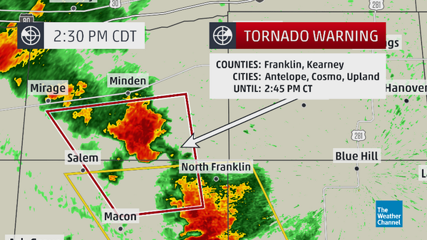
Tornado Warning for Kearney County, NE
until 2014-04-27 15:45:00.0
Other affected areas:
…
FRANKLIN, NE; KEARNEY, NE
Issued by The National Weather Service
Hastings, NE
Sun, Apr 27, 2014, 2:23 PM CDT
THE NATIONAL WEATHER SERVICE IN HASTINGS HAS ISSUED A
* TORNADO WARNING FOR... SOUTHERN KEARNEY COUNTY IN SOUTH CENTRAL NEBRASKA... NORTHEASTERN FRANKLIN COUNTY IN SOUTH CENTRAL NEBRASKA...
* UNTIL 245 PM CDT
* AT 221 PM CDT... A SEVERE THUNDERSTORM CAPABLE OF PRODUCING A TORNADO WAS LOCATED OVER UPLAND... OR 26 MILES EAST OF HOLDREGE... MOVING NORTHWEST AT 30 MPH.
HAZARD... TORNADO AND QUARTER SIZE HAIL.
SOURCE... RADAR INDICATED ROTATION.
IMPACT... FLYING DEBRIS WILL BE DANGEROUS TO THOSE CAUGHT WITHOUT SHELTER. MOBILE HOMES WILL BE DAMAGED OR DESTROYED. DAMAGE TO ROOFS... WINDOWS AND VEHICLES WILL OCCUR. TREE DAMAGE IS LIKELY.
* THIS DANGEROUS STORM WILL BE NEAR... HILDRETH AROUND 230 PM CDT.
PRECAUTIONARY/PREPAREDNESS ACTIONS...
TAKE COVER NOW! MOVE TO A BASEMENT OR AN INTERIOR ROOM ON THE LOWEST FLOOR OF A STURDY BUILDING. AVOID WINDOWS. IF IN A MOBILE HOME... A VEHICLE OR OUTDOORS... MOVE TO THE CLOSEST SUBSTANTIAL SHELTER AND PROTECT YOURSELF FROM FLYING DEBRIS.
&&
TORNADO... RADAR INDICATED HAIL... 1.00IN
A confirmed tornado touched down from 2:26-2:29pm CDT with this cell moving NW at 30 mph in southern Nebraska
First #tornado of the day - just north of Upland, Nebraska 2:26pm RT @Jonnywx: And we got ground circulation
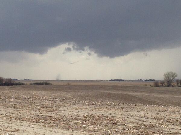
First #tornado of the day - just north of Upland, Nebraska 2:26pm RT @Jonnywx: And we got ground circulation
edit on 27-4-2014 by Havox because: (no reason given)
a reply to: liejunkie01
heres a interactive radar showing southern Illinois
www.kmov.com...
alright guys and gals im about to get on the road see what I can find heading a little further south in Arkansas than anticipated yesterday hope I can post some beautiful pictures. be safe y'all will update when possible
heres a interactive radar showing southern Illinois
www.kmov.com...
alright guys and gals im about to get on the road see what I can find heading a little further south in Arkansas than anticipated yesterday hope I can post some beautiful pictures. be safe y'all will update when possible
edit on 27-4-2014 by TechniXcality because: (no reason given)
Thanks to everyone for all the updates on this thread... stay safe everyone.
a reply to: TechniXcality
Thank you very much for that. I love the detail and specific features it shows on that radar. I also passed this on to a dispatch/safety center in the area I know someone in, who I know will find it equally useful.
Thank you very much for that. I love the detail and specific features it shows on that radar. I also passed this on to a dispatch/safety center in the area I know someone in, who I know will find it equally useful.
a reply to: Havox
yes sir and that is exactly where I am heading now just north of little rock I expect to see, explosive super cell development however I believe the severe risk is higher yet for areas north regardless of the text products of NWS considering storm motion
yes sir and that is exactly where I am heading now just north of little rock I expect to see, explosive super cell development however I believe the severe risk is higher yet for areas north regardless of the text products of NWS considering storm motion
a reply to: Havox
look at this frame latest nam hi res sim reflectivity 6 hrs mag.ncep.noaa.gov... aram=sim_reflectivity&fhr=006&group=Model+Guidance&imageSize=&ps=area&preselected_formatted_cycle_date=20140427+18+UTC&scrollx=0&scrolly=0
now the frame before shows the current activity exiting southern MO and moving off northeast. now click a few frames or time periods ahead and you can see people north of the high risk are absolutely at risk. Furthermore the low level jet will increase tonight furthering the potential for severe thunderstorms. be safe Ill keep updating im jamming right now heres what im listening to lol
edit on 27-4-2014 by TechniXcality because: (no reason given)

a reply to: Havox
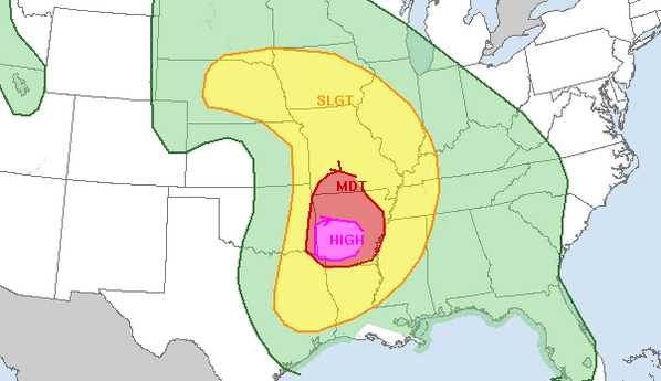
PDS Tornado watch in effect this is a very deadly situation please take head
URGENT - IMMEDIATE BROADCAST REQUESTED
TORNADO WATCH NUMBER 100
NWS STORM PREDICTION CENTER NORMAN OK
335 PM CDT SUN APR 27 2014
THE NWS STORM PREDICTION CENTER HAS ISSUED A
* TORNADO WATCH FOR PORTIONS OF
SOUTHWEST AND CENTRAL ARKANSAS
EXTREME SOUTHEAST OKLAHOMA
* EFFECTIVE THIS SUNDAY AFTERNOON AND EVENING FROM 335 PM UNTIL
1100 PM CDT.
...THIS IS A PARTICULARLY DANGEROUS SITUATION...
* PRIMARY THREATS INCLUDE...
NUMEROUS TORNADOES EXPECTED WITH A FEW INTENSE TORNADOES LIKELY
WIDESPREAD LARGE HAIL AND ISOLATED VERY LARGE HAIL EVENTS TO 2.5
INCHES IN DIAMETER LIKELY
SCATTERED DAMAGING WINDS AND ISOLATED SIGNIFICANT GUSTS TO 80
MPH POSSIBLE
THE TORNADO WATCH AREA IS APPROXIMATELY ALONG AND 65 STATUTE
MILES NORTH AND SOUTH OF A LINE FROM 30 MILES NORTH OF DE QUEEN
ARKANSAS TO 50 MILES EAST NORTHEAST OF PINE BLUFF ARKANSAS. FOR
A COMPLETE DEPICTION OF THE WATCH SEE THE ASSOCIATED WATCH
OUTLINE UPDATE (WOUS64 KWNS WOU0).
PRECAUTIONARY/PREPAREDNESS ACTIONS...
REMEMBER...A TORNADO WATCH MEANS CONDITIONS ARE FAVORABLE FOR
TORNADOES AND SEVERE THUNDERSTORMS IN AND CLOSE TO THE WATCH
AREA. PERSONS IN THESE AREAS SHOULD BE ON THE LOOKOUT FOR
THREATENING WEATHER CONDITIONS AND LISTEN FOR LATER STATEMENTS
AND POSSIBLE WARNINGS.
&&
OTHER WATCH INFORMATION...CONTINUE...WW 95...WW 96...WW 97...WW
98...WW 99...
DISCUSSION...DISCRETE STORMS ARE BEGINNING TO DEVELOP ALONG THE
DRYLINE NEAR THE RED RIVER IN SE OK...WHILE OTHER CONVECTION IS
EXPECTED TO DEVELOP FARTHER S IN NE TX THE REMAINDER OF THE
AFTERNOON. THESE STORMS WILL MOVE ENEWD INTO THE WARM SECTOR AND
MATURE...AND WILL ENCOUNTER AN INCREASINGLY FAVORABLE ENVIRONMENT
FOR TORNADOES IN AR. LOW-LEVEL SHEAR IS VERY STRONG ALONG A
RESIDUAL OUTFLOW BOUNDARY ACROSS CENTRAL AR...AND THE LOW LEVELS
WILL SLOWLY WARM AND MOISTEN IN THE WAKE OF EARLIER CONVECTION.
DISCRETE SUPERCELLS MOVING INTO THIS ENVIRONMENT WILL HAVE THE
POTENTIAL TO PRODUCE LONG TRACK...STRONG/VIOLENT TORNADOES WELL INTO
THE EVENING.
AVIATION...TORNADOES AND A FEW SEVERE THUNDERSTORMS WITH HAIL
SURFACE AND ALOFT TO 2.5 INCHES. EXTREME TURBULENCE AND SURFACE
WIND GUSTS TO 70 KNOTS. A FEW CUMULONIMBI WITH MAXIMUM TOPS TO
550. MEAN STORM MOTION VECTOR 24035.
...THOMPSON
a reply to: Wrabbit2000
storms developing southwest of Springfield haven't had a chance to analysis them but very well could be super cells
storms developing southwest of Springfield haven't had a chance to analysis them but very well could be super cells
new topics
-
AI phrenology
Science & Technology: 4 hours ago -
4/27/24 New Jersey Earthquake
Fragile Earth: 10 hours ago -
Fun with extreme paints
Interesting Websites: 11 hours ago
top topics
-
Canada caught red-handed manipulating live weather data and make it warmer
Fragile Earth: 16 hours ago, 16 flags -
Why Files Our Alien Overlords | How We Secretly Serve The Tall Whites
Aliens and UFOs: 17 hours ago, 12 flags -
4/27/24 New Jersey Earthquake
Fragile Earth: 10 hours ago, 8 flags -
I sleep no more.
Philosophy and Metaphysics: 15 hours ago, 6 flags -
CIA is alleged to be operat social media troll frms in Kyiv
ATS Skunk Works: 12 hours ago, 6 flags -
AI phrenology
Science & Technology: 4 hours ago, 3 flags -
Fun with extreme paints
Interesting Websites: 11 hours ago, 2 flags -
Rainbow : Stargazer
Music: 13 hours ago, 1 flags
active topics
-
Why Files Our Alien Overlords | How We Secretly Serve The Tall Whites
Aliens and UFOs • 15 • : ChaoticOrder -
Killings of Palestinian children are soaring in the West Bank.
World War Three • 161 • : ToneD -
AI phrenology
Science & Technology • 11 • : 777Vader -
Joe Biden Facing Criminal Charges In Ukraine
Mainstream News • 95 • : WeMustCare -
Blast from the past: ATS Review Podcast, 2006: With All Three Amigos
Member PODcasts • 4 • : theshadowknows -
A Warning to America: 25 Ways the US is Being Destroyed
New World Order • 35 • : Loadandgo -
Hurt my hip; should I go see a Doctor
General Chit Chat • 25 • : stonerwilliam -
Gee, that didn't age well.
Social Issues and Civil Unrest • 11 • : WeMustCare -
Krystalnacht on today's most elite Universities?
Social Issues and Civil Unrest • 23 • : ToneD -
BIDEN Admin Begins Planning For January 2025 Transition to a New President - Today is 4.26.2024.
2024 Elections • 31 • : WeMustCare