It looks like you're using an Ad Blocker.
Please white-list or disable AboveTopSecret.com in your ad-blocking tool.
Thank you.
Some features of ATS will be disabled while you continue to use an ad-blocker.

Severe Weather Outbreaks 2014
page: 3share:
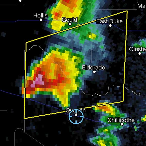
Warnings coming out now for storms near Altus. The lower level jet is cranking up like mad, even without tornadoes the storms could continue to pack a
pretty big punch!
Now we are enjoying the Earthquake? Thunder? Wind? Game. 3 small ones in the last hour.
The storms near Altus apppear to be cycling and rebuilding.
The storms near Altus apppear to be cycling and rebuilding.
I feel for all you folks living in the path of this system. It looks like it could develop into a monster.
I lived through a couple of tornados years ago; not a direct hit, but very close (1/4 mile away) and causing a lot of damge, and it’s no picnic. I’ve also seen a few funnels pass by, but was far enough away to not sustain any damage. Big winds make me nervous.
For most of my life, though, I’ve lived on the west coast (one beach or another). Believe me, I’ll take my chances with an earthquake any day over a tornado or hurricane.
Best of luck to all of you...
a reply to: Answer
no actually Dallas is right on the verge the models show the dry line moving east of 35 before storm initiation looks like from Terrell eastward you might worry about isolated tornadic super cells . a few days ago the models were painting a different picture but as we get closer to the event the models fine tune their rough analysis. Im in Missouri and am looking forward to the show
for your reference and analysis: (latest 00utc nam-hi res model) just click next shows the simulated convective bright banding
mag.ncep.noaa.gov... aram=sim_reflectivity&fhr=024&group=Model+Guidance&imageSize=&ps=area&preselected_formatted_cycle_date=20140427+00+UTC&scrollx=0&scrolly=0
edit
on 26-4-2014 by TechniXcality because: (no reason given)
edit on 26-4-2014 by TechniXcality because: (no reason given)
Oh boy, I was just checking in on a hunch and this thread grabbed my attention. Looks like we sit smack dab in the middle of the red. Although we are
no strangers to bad weather, nature can be so powerful, awesome and deadly.
Power of prayer? Better get down on your knee's for those in the path of destructive storms tomorrow. I will try to check back here during the event.
Power of prayer? Better get down on your knee's for those in the path of destructive storms tomorrow. I will try to check back here during the event.
It looks like things are calming down for now. So we hunker down to wait and watch what the dyline will do overnight, it looks like central Arkansas
will be in for a very bumpy ride tomorrow.
a reply to: gluetrap
very true according to spc ( storm prediction center)( www.spc.noaa.gov... ) Arkansas is right smack dab in the middle of the action(if you click the link there is a good discussion). I hope to chase some storms tomorrow evening im in south east Missouri for work im glad by job allows me time to do the things I love.
very true according to spc ( storm prediction center)( www.spc.noaa.gov... ) Arkansas is right smack dab in the middle of the action(if you click the link there is a good discussion). I hope to chase some storms tomorrow evening im in south east Missouri for work im glad by job allows me time to do the things I love.
a reply to: TechniXcality
You bet, but I wanted to say that going out without a professional storm chaser is not wise. Now I am probably young enough to be your Mother so, wisdom with age and all of that jolly stuff.
I once found myself surrounded by pitch black, pounding rains and wind to the point of the truest zero visibility and I can tell you it was exciting but very very deadly and unpredictable.
The Midwest has storms that almost have souls or something they are so wise and accurate when it comes to the flesh of humans in their way.
Best to be humble and hunker down or at least, at least be within 2 feet from the door to your bugout.
Be safe ok? Promise me.
PARTS OF ARK AND PERHAPS EXTREME EASTERN OK... ARE EXPECTED TO EXPERIENCE LIFE-THREATENING STORMS SUNDAY. Looks like the severe potential has yet
again increased. The tornado threat itself has increased as well. Risk is about 70% for tornadoes. Hard to say if they will be long tracked ones or
short lived, violent ones. Tomorrow's severe weather includes long track tornados. I'm very concerned that a number of cities could be hit. PLEASE
PREPARE FOR THE WORST
www.facebook.com...
www.facebook.com...
For what it's worth... Please.. Don't anyone take this one lightly. MAYBE it craps out. They have before..however..
A pilot friend of mine who I'd trust with more than my wallet if it came to it, passed on to me on Friday that meteorology was indicating the worst atmosphere for violent storms over Southern Missouri since the Joplin tornado. I'd sure take that to extend across the warning area, but I'm passing on specifically what I was told.
I think this one is going to hurt a bit..and stay safe out there everyone.
Remember....a full bathtub is A LOT of drinking water to sit available in days following a bad disaster. Just a thought to add. I hope none of us need it.
** I just saw this and thought I would add it..
It crossed Breaking News about 2 hours ago and I was over checking what was recent. Another alert indicated a Winter Weather advisory over parts of Colorado. (sigh) ..this is going to get wild I think.
National Wind Map with near-real time patterns
A pilot friend of mine who I'd trust with more than my wallet if it came to it, passed on to me on Friday that meteorology was indicating the worst atmosphere for violent storms over Southern Missouri since the Joplin tornado. I'd sure take that to extend across the warning area, but I'm passing on specifically what I was told.
I think this one is going to hurt a bit..and stay safe out there everyone.
Remember....a full bathtub is A LOT of drinking water to sit available in days following a bad disaster. Just a thought to add. I hope none of us need it.
** I just saw this and thought I would add it..
Wind gusts of up to 72 mph reported northwest of Fort Bliss, El Paso County, Texas - @breakingweather
It crossed Breaking News about 2 hours ago and I was over checking what was recent. Another alert indicated a Winter Weather advisory over parts of Colorado. (sigh) ..this is going to get wild I think.
National Wind Map with near-real time patterns
edit on 26-4-2014 by Wrabbit2000 because: (no reason
given)
I'm starting to get pretty nervous.
We are having our son by c section on monday.
I hope it dies down and misses us. It is a 40 minute drive to the hospital monday morning at 5:30.
I'm scared, lj01 needs a hug and someone to tell me it will be ok.
We are having our son by c section on monday.
I hope it dies down and misses us. It is a 40 minute drive to the hospital monday morning at 5:30.
I'm scared, lj01 needs a hug and someone to tell me it will be ok.
a reply to: antar
I completely agree with you my fascination may one day be the end of me, but if it is I went doing something I love. I suppose that is better than going and being miserable. I promise I will be safe tommarow ill be watching radar from lap top and trying not to get directly under a rotating wall cloud ill keep a few miles south west of the the rotation(visibility permitting which may be a limiting factor due to the high precipitation these super cells will have) But thank you for your concern and I will give y'all updates tommarow from south east Mo specifically poplar bluff area
I completely agree with you my fascination may one day be the end of me, but if it is I went doing something I love. I suppose that is better than going and being miserable. I promise I will be safe tommarow ill be watching radar from lap top and trying not to get directly under a rotating wall cloud ill keep a few miles south west of the the rotation(visibility permitting which may be a limiting factor due to the high precipitation these super cells will have) But thank you for your concern and I will give y'all updates tommarow from south east Mo specifically poplar bluff area
edit on 26-4-2014 by TechniXcality because: (no reason given)
originally posted by: liejunkie01
I'm starting to get pretty nervous.
We are having our son by c section on monday.
I hope it dies down and misses us. It is a 40 minute drive to the hospital monday morning at 5:30.
I'm scared, lj01 needs a hug and someone to tell me it will be ok.
Awwwww...come on over here, Lj01. We could all use one.
Group Hug...

Everything is going to be just fine with your sweet little Baby. Sending prayers for serenity and good health. And calm weather for the birth of your new Son.
Des
edit on 27-4-2014 by Destinyone because: (no reason given)
a reply to: Havox
latest special weather statement per little rock Arkansas NWS (national weather service) covering the majority of the state.
Special Weather Statement
SPECIAL WEATHER STATEMENT
NATIONAL WEATHER SERVICE LITTLE ROCK AR
253 PM CDT SAT APR 26 2014
ARZ003>007-012>016-021>025-030>034-037>047-052>057-062>069-270900-
ARKANSAS-BAXTER-BOONE-BRADLEY-CALHOUN-CLARK-CLEBURNE-CLEVELAND-
CONWAY-DALLAS-DESHA-DREW-FAULKNER-FULTON-GARLAND-GRANT-HOT SPRING-
INDEPENDENCE-IZARD-JACKSON-JEFFERSON-JOHNSON-LINCOLN-LOGAN-LONOKE-
MARION-MONROE-MONTGOMERY-NEWTON-OUACHITA-PERRY-PIKE-POLK-POPE-
PRAIRIE-PULASKI-SALINE-SCOTT-SEARCY-SHARP-STONE-VAN BUREN-WHITE-
WOODRUFF-YELL-
INCLUDING THE CITIES OF...ALTHEIMER...AMITY...ARKADELPHIA...
ARKANSAS CITY...ASH FLAT...AUGUSTA...AVILLA...BATESVILLE...
BAUXITE...BEARDEN...BEE BRANCH...BEEBE...BENTON...BISMARCK...
BONNERDALE...BOONEVILLE...BRINKLEY...BRYANT...BULL SHOALS...
CABOT...CALICO ROCK...CAMDEN...CAVE CITY...CENTER RIDGE...
CHIDESTER...CLARENDON...CLARKSVILLE...CLINTON...CONWAY...
COTTON PLANT...DANVILLE...DARDANELLE...DE VALLS BLUFF...DE WITT...
DEER...DES ARC...DONALDSON...DRASCO...DUMAS...EL PASO...ENGLAND...
FAIRFIELD BAY...FLIPPIN...FORDYCE...FOURCHE JUNCTION...
GASSVILLE...GEORGETOWN...GILLETT...GLENWOOD...GOULD...GRADY...
GRAVELLY...GREENBRIER...GREERS FERRY...GURDON...HAMPTON...HARDY...
HARRISON...HASKELL...HAZEN...HEBER SPRINGS...HECTOR...HERMITAGE...
HORSESHOE BEND...HOT SPRINGS...HOT SPRINGS VILLAGE...HOUSTON...
HUMNOKE...HUMPHREY...JACKSONVILLE...JASPER...JESSIEVILLE...
KINGSLAND...LACEY...LEAD HILL...LEOLA...LESLIE...LITTLE ROCK...
LONOKE...MALVERN...MAMMOTH SPRING...MARSHALL...MAUMELLE...
MAYFLOWER...MCCRORY...MCGEHEE...MELBOURNE...MENA...MONTICELLO...
MORO BAY...MORRILTON...MOUNT IDA...MOUNT MAGAZINE...
MOUNTAIN HOME...MOUNTAIN VIEW...MURFREESBORO...NEWPORT...
NORFORK...NORMAN...NORTH LITTLE ROCK...OIL TROUGH...OKOLONA...
OLA...OMAHA...OXFORD...OZONE...PARIS...PARON...PELSOR...
PERRYVILLE...PINE BLUFF...PINE RIDGE...PLEASANT PLAINS...POYEN...
PRATTSVILLE...REDFIELD...RISON...ROHWER...ROSE BUD...
RUSSELLVILLE...SALEM...SEARCY...SHERIDAN...SHERWOOD...STAR CITY...
STEPHENS...STUTTGART...SUMMIT...SWIFTON...THORNTON...TUCKERMAN...
VILONIA...VIOLA...WALDRON...WARREN...WESTERN GROVE...WICKES...
WRIGHTSVILLE...Y CITY...YELLVILLE
253 PM CDT SAT APR 26 2014
...SEVERE THUNDERSTORMS AND HEAVY RAIN EXPECTED IN ARKANSAS SUNDAY
AND INTO MONDAY...
A POWERFUL STORM SYSTEM OUT IN THE PLAINS WILL AFFECT ARKANSAS
BEGINNING SUNDAY. SHOWERS AND THUNDERSTORMS WILL DEVELOP AND
OVERSPREAD THE STATE DURING THE MORNING. BY THE AFTERNOON...STORMS
WILL BE WIDESPREAD...AND THESE WILL CONTINUE INTO THE OVERNIGHT HOURS
SUNDAY NIGHT AND MONDAY MORNING.
SOME STORMS WILL BE SEVERE...ESPECIALLY ON SUNDAY AFTERNOON AND
NIGHT. ANY SEVERE STORMS WILL HAVE THE CAPABILITY OF PRODUCING
LARGE HAIL IN EXCESS OF TWO INCHES IN DIAMETER. THERE IS A HIGH
AMOUNT OF WIND ENERGY PRESENT IN ALL LAYERS OF THE ATMOSPHERE...
SO DAMAGING WIND GUSTS IN EXCESS OF 60 MPH WILL BE A THREAT WITH
ANY SEVERE STORMS AS WELL. ALSO...WINDS WILL BE TURNING AND INCREASING
WITH HEIGHT...WHICH WILL SUPPORT A TORNADO THREAT. THE HIGHEST
LIKELIHOOD FOR SEVERE THUNDERSTORMS WILL BE SUNDAY AND SUNDAY
NIGHT.
WITH A HIGH DEGREE OF LOW LEVEL MOISTURE PRESENT...STRONGER STORMS
WILL HAVE THE CAPABILITY OF PRODUCING HEAVY RAINFALL. THE TENDENCY
OF STORMS TO FORM AND MOVE OVER THE SAME AREAS WILL ONLY INCREASE
THIS THREAT. THROUGH MONDAY...MUCH OF THE STATE IS EXPECTED TO SEE
ONE TO THREE INCHES OF RAIN. THE HEAVIEST RAINFALL IS EXPECTED
ALONG AND EAST OF THE INTERSTATE 30 AND U. S. HIGHWAY 67 CORRIDOR...
WHERE AMOUNTS OVER THREE INCHES ARE LIKELY. RAIN IS EXPECTED TO BE
HEAVIEST SUNDAY AFTERNOON AND NIGHT.
NOW IS THE TIME TO REVIEW YOUR SEVERE WEATHER SAFETY RULES.
CONTINUE TO MONITOR THE LATEST FORECASTS AND OUTLOOKS FROM YOUR
NATIONAL WEATHER SERVICE OFFICE. AND MOST IMPORTANTLY...MAKE SURE
YOU HAVE A PLAN AND ARE PREPARED WHEN A WATCH OR WARNING IS ISSUED
FOR YOUR AREA.
edit on 26-4-2014 by TechniXcality because: (no reason given)
a reply to: liejunkie01
where in the mid west are you? I do believe you will be fine and there will be ample warning in the event of danger as all meteorologist are waiting with anticipation and glued to the models and radar.. don't worry you and your baby will be fine I promise
where in the mid west are you? I do believe you will be fine and there will be ample warning in the event of danger as all meteorologist are waiting with anticipation and glued to the models and radar.. don't worry you and your baby will be fine I promise
This is for south east MO and Kentucky just issued from the NWS
HAZARDOUS WEATHER OUTLOOK
NATIONAL WEATHER SERVICE PADUCAH KY
1123 PM CDT SAT APR 26 2014
ILZ075>078-080>094-INZ081-082-085>088-KYZ001>022-MOZ076-086-087-
100-107>112-114-271000-
JEFFERSON-WAYNE IL-EDWARDS-WABASH-PERRY IL-FRANKLIN-HAMILTON-
WHITE-JACKSON-WILLIAMSON-SALINE-GALLATIN-UNION IL-JOHNSON-POPE-
HARDIN-ALEXANDER-PULASKI-MASSAC-GIBSON-PIKE-POSEY-VANDERBURGH-
WARRICK-SPENCER-FULTON-HICKMAN-CARLISLE-BALLARD-MCCRACKEN-GRAVES-
LIVINGSTON-MARSHALL-CALLOWAY-CRITTENDEN-LYON-TRIGG-CALDWELL-
UNION KY-WEBSTER-HOPKINS-CHRISTIAN-HENDERSON-DAVIESS-MCLEAN-
MUHLENBERG-TODD-PERRY MO-BOLLINGER-CAPE GIRARDEAU-WAYNE MO-CARTER-
RIPLEY-BUTLER-STODDARD-SCOTT-MISSISSIPPI-NEW MADRID-
1123 PM CDT SAT APR 26 2014
THIS HAZARDOUS WEATHER OUTLOOK IS FOR PORTIONS OF SOUTHERN
ILLINOIS...SOUTHWEST INDIANA...WESTERN KENTUCKY AND SOUTHEAST
MISSOURI.
.DAY ONE...TONIGHT
NO HAZARDOUS WEATHER IS EXPECTED AT THIS TIME.
.DAYS TWO THROUGH SEVEN...SUNDAY THROUGH FRIDAY
THUNDERSTORMS ARE FORECAST FROM SUNDAY THROUGH TUESDAY NIGHT.
MULTIPLE ROUNDS OF SEVERE WEATHER AND HEAVY RAINFALL WILL BE
POSSIBLE FROM SUNDAY AFTERNOON THROUGH TUESDAY. THE POTENTIAL
EXISTS FOR A SIGNIFICANT OUTBREAK OF SEVERE STORMS IN THIS
PERIOD...WITH TORNADOES...VERY LARGE HAIL...AND DESTRUCTIVE
STRAIGHT LINE WINDS ALL POSSIBLE. IN ADDITION...EACH ROUND OF
THUNDERSTORMS WILL PRODUCE LOCALLY HEAVY RAINFALL...AND MAY
EVENTUALLY LEAD TO SOME FLASH FLOODING IN AREAS THAT RECEIVE
MULTIPLE ROUNDS OF VERY HEAVY RAIN.
.SPOTTER INFORMATION STATEMENT...
SPOTTER ACTIVATION WILL LIKELY BE REQUESTED THROUGHOUT THE AREA
SUNDAY AFTERNOON...AND AGAIN AT SOME POINT MONDAY THROUGH TUESDAY.
this out of Tulsa OK
...SEVERE STORMS LIKELY SUNDAY WITH A THREAT OF TORNADOES...
WHILE THERE REMAINS SOME UNCERTAINTY RELATING TO THE SPECIFIC AREAS
THAT WILL BE AT MOST RISK...PARTS OF ARKANSAS AND PERHAPS EXTREME
EASTERN OKLAHOMA...ARE EXPECTED TO EXPERIENCE LIFE-THREATENING
STORMS SUNDAY EVENING. THAT THREAT INCLUDES THE POTENTIAL FOR
STRONG AND POSSIBLY LONG-TRACK TORNADOES.
IF YOU ARE IN ARKANSAS OR EXTREME EASTERN OKLAHOMA YOU SHOULD USE
THIS EVENING TO REVIEW YOUR SEVERE ACTIONS PLANS. THIS SHOULD BE
DONE NOT ONLY FOR YOUR HOME...BUT ALSO FOR WHERE YOU EXPECT TO BE
SUNDAY EVENING. THIS IS ALSO A GOOD TIME TO CHECK BATTERY-POWER
DEVICES AND ENSURE YOUR FAMILY CAN QUICKLY SEEK SHELTER IF
NECESSARY.
also the 00z models are in and I believe a high risk will be issued tomorrow morning for the mid west. This is a particularly dangerous situation the models are painting a very violent picture. heads up be safe y'all
edit on 27-4-2014 by TechniXcality because: (no reason given)
I believe we should use this thread to post updates and storm reports from what the latest models are reading tomorrow may be a history maker. I pray
this not true my fascination ends when human life is taken or destroyed. Id rather sacrifice my self and help someone who is truly in need be safe you
all love you and this community
new topics
-
Jean Michel and Brian May Live from Bratislava
General Chit Chat: 3 hours ago -
Iranian Lawmaker Declares Iran Has Nuclear Weapons
Mainstream News: 4 hours ago -
Biden Withholding Sensitive US Intelligence on Hamas Leaders From Israel
US Political Madness: 7 hours ago -
Anybody else go to the movie theater a lot? Have you noticed how dead they are?
General Chit Chat: 7 hours ago -
Trump Record Breaking Campaign Rally 5/11 in New Jersey Draws 100,000 People
2024 Elections: 7 hours ago -
something falls in Canada
Aliens and UFOs: 8 hours ago -
US mistakes in assessing the military potential of China and Russia
ATS Skunk Works: 10 hours ago
top topics
-
Trump Record Breaking Campaign Rally 5/11 in New Jersey Draws 100,000 People
2024 Elections: 7 hours ago, 14 flags -
Biden Withholding Sensitive US Intelligence on Hamas Leaders From Israel
US Political Madness: 7 hours ago, 10 flags -
Anybody else go to the movie theater a lot? Have you noticed how dead they are?
General Chit Chat: 7 hours ago, 7 flags -
Jean Michel and Brian May Live from Bratislava
General Chit Chat: 3 hours ago, 5 flags -
US mistakes in assessing the military potential of China and Russia
ATS Skunk Works: 10 hours ago, 4 flags -
something falls in Canada
Aliens and UFOs: 8 hours ago, 4 flags -
Iranian Lawmaker Declares Iran Has Nuclear Weapons
Mainstream News: 4 hours ago, 3 flags
active topics
-
Candidate TRUMP Now Has Crazy Judge JUAN MERCHAN After Him - The Stormy Daniels Hush-Money Case.
Political Conspiracies • 1502 • : xuenchen -
The biggest problem with the Hush money trial
US Political Madness • 178 • : xuenchen -
Bibi’s Dilemma
Middle East Issues • 243 • : KrustyKrab -
Trump Record Breaking Campaign Rally 5/11 in New Jersey Draws 100,000 People
2024 Elections • 69 • : Irishhaf -
Biden Withholding Sensitive US Intelligence on Hamas Leaders From Israel
US Political Madness • 48 • : Dalamax -
Joe Biden and Donald Trump are both traitors
2024 Elections • 75 • : burritocat -
Christianity superior to other faiths for very specific reasons. Awaken to true FREEDOM..!!
Conspiracies in Religions • 28 • : jofafot -
Iranian Lawmaker Declares Iran Has Nuclear Weapons
Mainstream News • 16 • : DBCowboy -
Jean Michel and Brian May Live from Bratislava
General Chit Chat • 4 • : Flyingclaydisk -
Anybody else go to the movie theater a lot? Have you noticed how dead they are?
General Chit Chat • 14 • : Drugstorecowboy56