It looks like you're using an Ad Blocker.
Please white-list or disable AboveTopSecret.com in your ad-blocking tool.
Thank you.
Some features of ATS will be disabled while you continue to use an ad-blocker.

Quake Watch 2014
page: 56share:
5.0 aftershock right now for the north van island region: earthquake.usgs.gov...
edit: nvm, already posted.
4.2 aftershock as well for north van island. earthquake.usgs.gov...
edit: nvm, already posted.
edit on 23-4-2014 by phoenixlights321 because: (no reason given)
4.2 aftershock as well for north van island. earthquake.usgs.gov...
edit on 23-4-2014 by phoenixlights321 because: (no reason given)
My good friend in Japan said she felt a quake at ~3am PST. She lives between Osaka and Kobe. Make that 1am PST, she said in the message that she
felt it about 2hrs ago and the message time was 3am.
edit on 24-4-2014 by AlexanderM because: (no reason given)
originally posted by: AlexanderM
My good friend in Japan said she felt a quake at ~3am PST. She lives between Osaka and Kobe. Make that 1am PST, she said in the message that she felt it about 2hrs ago and the message time was 3am.
Wasn't at 3:33 was it. could have been the mother ship.
In regards to the 6.6 in Vancouver. I can't believe how passive everyone on the west coast seems. An earthquake would be bad enough, but a
tsunami would be devastating. Vancouver is listed as one of the most threatened cities in the whole world [12th place] regarding a 20cm increase in
sea level [only about 6 inches]. Imagine a 5, 10 or 20 foot tsunami. A site I found shows that in 2008 there were 79,140 residents and a daytime
employee base of 145,000 all in downtown vancouver alone. A mere 90 city blocks [about 10 square blocks]. There has been a increase of 10-15% in
population in that area over 5 years... so the numbers are probably closer to 300'000 people. In downtown alone. They'll have nowhere to go if a
tsunami hits. Infrastructure damaged by earthquakes, and any operable roads clogged by tens of thousands of panicking citizens. Richmond and Surrey
will be even worse off than Vancouver. I'm just glad I live on a good elevation... but where I work could be underwater... and that's only a half hour
away.
edit on 24-4-2014 by LeviWardrobe because: (no reason given)
a reply to: Evltre
Depends what you call quiet.
There are ongoing aftershocks from Christchurch, Cook Strait, Eketahuna and Waipukurau still at this point.
Seems background seismicity returning to normal, familiar names coming back on in the last week, Waiouru, Wairoa, White Island....
The old familiar ones missing recently are Matata, Taupo and off Whakatane, so we could say Taupo Volcanic Zone is pretty quiet too.
The map to see the "hot spots" is the April 2014 one.
So there is definitely stuff going on, but its small ones, what is missing is the M5+ quakes, and even Kermadecs until yesterdays M4.9 has been quiet.
April summary so far;
mag1= 563 , mag2= 697 , mag3= 146
mag4= 10 , mag5= 0 , mag6= 0
total= 1,416
total energy released= 1,415.255 TTNT
I just found out that I accidentally deleted the Jan and Feb monthly maps from Dropbox, so at the moment you can't compare with other months, the previos years are there though eg 2013
One area that I noticed had a few rare M3's on the 7th, 18th and 20th UTC, is in the Kakanu Mt's between Oamaru and Dunedin.
Graphs here
originally posted by: muzzy
I've loaded Geonets mobile phone alert app. info.geonet.org.nz...
I set the sound to "knock, knock, knock" and vibrate. And quiet time 9pm-5am where it just sends a message with no sound.
Seems the last 2 days it goes off in the early morning the most. Nothing much happening, biggest one so far was a 3.8 this morning off East Cape.
Expect if a big one hits it will go off like a woodpecker!
Not sure how this works yet, certainly don't get ALL the events (up to 50 a day shows on their data), so it must only be those that the seismologist on duty has had a look at. Although its a cell phone app. you have to be connected to w-fi to get the notifications it seems. That would explain the early morning flurry of notifications.
I was out of town yesterday and when I returned and parked up in my driveway within range of our wi-fi router my cell phone went nuts with "knock, knocks" LOL, just like I said sounded like woodpecker .
a reply to: muzzy
Quick question if I may. You seem to be one of the guys in the know. I've been watching and trying to learn. I thought quakes were cause by friction in the plates for the most part. Some of the recent USGS reported quakes have came in at 0 depth while a couple have come in in excess of 500 km. the crust (plate) thickness varies but averages around 50km. the ones at 500km are in the asthenosphere a semi molten zone. Would quakes that far down be normal and also a possible indication of magma flow more than a friction event.
Quick question if I may. You seem to be one of the guys in the know. I've been watching and trying to learn. I thought quakes were cause by friction in the plates for the most part. Some of the recent USGS reported quakes have came in at 0 depth while a couple have come in in excess of 500 km. the crust (plate) thickness varies but averages around 50km. the ones at 500km are in the asthenosphere a semi molten zone. Would quakes that far down be normal and also a possible indication of magma flow more than a friction event.
originally posted by: batcrapcrazy
a reply to: muzzy
Quick question if I may. You seem to be one of the guys in the know. I've been watching and trying to learn. I thought quakes were cause by friction in the plates for the most part. Some of the recent USGS reported quakes have came in at 0 depth while a couple have come in in excess of 500 km. the crust (plate) thickness varies but averages around 50km. the ones at 500km are in the asthenosphere a semi molten zone. Would quakes that far down be normal and also a possible indication of magma flow more than a friction event.
I will answer for the time being if I may.
Quakes are if anything caused by a lack of friction rather than the friction. The theory is that when two plates are sliding past each other all is well. When they friction gets too great the plate gets 'locked'. There is no friction at this point, or is there, as the sliding has stopped. (If the surfaces are not moving relative to each other is there friction? The resistance that one surface or object encounters when moving over another is the description of friction, but the surfaces have ceased moving) Now the stress begins to build up. At some point the amount of stress becomes great enough to start the plates moving again - and the do so with a big jolt - an earthquake as we call it.
A depth of 0km is more than likely where they have not determined it, or even where the cause is something like a mine explosion (blasting). Generally quakes at 500km deep are occurring in the Wadati-Benioff Zone (also known as a subduction zone) where the theory states that the slab is descending and is cold (relatively) thus is still 'brittle' and not pliable yet. As you correctly state normally this sort of depth the asthenosphere is semi-molten.
This is not the only explanation but it is the current accepted theoretical answer so until you have a better understanding it will be more than sufficient (I hope) to state current thinking rather than alternative theories that have yet to reach acceptance.
a reply to: PuterMan
thank you very much. very informative and gives me alot of info to look up. I thought 0 depth was kinds weird myself and keep waiting to see it changed or taken off. there had been a couple like that. If I remember they were in the 2 - 3 mag range but could be wrong. That would be one hell of a mine explosion. they came up on the USGS Quake watch that only list 2.5 or greater usgs quake watch so I guess my memory was correct as they had to be at or above 2.5.
thank you very much. very informative and gives me alot of info to look up. I thought 0 depth was kinds weird myself and keep waiting to see it changed or taken off. there had been a couple like that. If I remember they were in the 2 - 3 mag range but could be wrong. That would be one hell of a mine explosion. they came up on the USGS Quake watch that only list 2.5 or greater usgs quake watch so I guess my memory was correct as they had to be at or above 2.5.
a reply to: PuterMan
THERE you are!
Been on holiday???
Happy belated birthday!!!
No day with firecrackers this year though!
Back ot...with obligatory quake question...
When I saw the 'clumping' quakes in Alaska & Calif.,
before the quake in Port Hardy,
I wondered if something would snap in between there!
Can that be a sign that something is about to give?
There are small swarms regularly,
but I've never noticed two so close in area,
that seemed to keep pace with each other before.
But then again, it IS Alaska & Calif.!
WOQ
a reply to: batcrapcrazy
what P'man said and to add my thoughts,
that asthenosphere level is only theoretical, it probably varies by 100's of km from place to place.
I always look at those deep S of Fiji quakes and think of the subducting edge of the Pacific Plate being heated by the core and the rock exploding. Probably a bit simplistic.
earthquake.usgs.gov...
M4.0
- 127km S of Masset, Canada
2014-04-25 05:12:41 UTC
Event Time
2014-04-25 05:12:41 UTC
2014-04-24 20:12:41 UTC-09:00 at epicenter
2014-04-24 22:12:41 UTC-07:00 system time
Location
52.871°N 132.164°W depth=10.0km (6.2mi)
Nearby Cities
127km (79mi) S of Masset, Canada
201km (125mi) SW of Prince Rupert, Canada
297km (185mi) SW of Terrace, Canada
576km (358mi) NW of Campbell River, Canada
621km (386mi) SSE of Juneau, Alaska
More shifting in the area now more north. Stay alert.
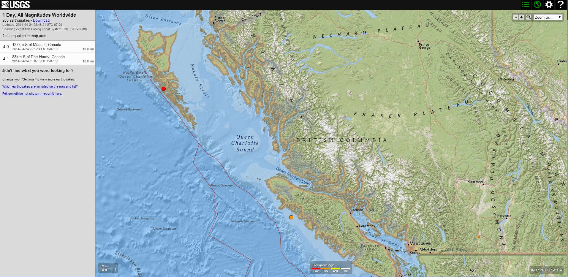
files.abovetopsecret.com...
M4.0
- 127km S of Masset, Canada
2014-04-25 05:12:41 UTC
Event Time
2014-04-25 05:12:41 UTC
2014-04-24 20:12:41 UTC-09:00 at epicenter
2014-04-24 22:12:41 UTC-07:00 system time
Location
52.871°N 132.164°W depth=10.0km (6.2mi)
Nearby Cities
127km (79mi) S of Masset, Canada
201km (125mi) SW of Prince Rupert, Canada
297km (185mi) SW of Terrace, Canada
576km (358mi) NW of Campbell River, Canada
621km (386mi) SSE of Juneau, Alaska
More shifting in the area now more north. Stay alert.
files.abovetopsecret.com...
edit on 7/30/2012 by dreamfox1 because: (no reason given)
a reply to: pheonix358
Puterman
I said in the above post
I have been waiting for a long time for two series of quakes to occur that would be necessary precursors. Those are happening now.
One series is on the southern border of Alaska and Canada, the other is along the western side of British Columbia.
I think the West Coast will go and I maintain 0 - 23 months as the time. The more quakes in these two zones, the sooner it will happen.
P
Puterman
I said in the above post
I see the remaining quadrant going in from anytime now to 24 months.
I have been waiting for a long time for two series of quakes to occur that would be necessary precursors. Those are happening now.
One series is on the southern border of Alaska and Canada, the other is along the western side of British Columbia.
I think the West Coast will go and I maintain 0 - 23 months as the time. The more quakes in these two zones, the sooner it will happen.
P
a reply to: pheonix358
Can you make that 4-23 months please.
I plan to be in Vancouver and Victoria in July.
Hopefully that 4.0 off Queen Charlotte Is. means the Plate has rotated some more (P'mans theory) and passed another snag.
If so then Alaska should be the next location to get hit. Hopefully low magnitude and in some isolated place.
edit on 04u11411414 by muzzy
because: (no reason given)
originally posted by: muzzy
a reply to: Evltre
I just found out that I accidentally deleted the Jan and Feb monthly maps from Dropbox, so at the moment you can't compare with other months, the previous years are there though eg 2013
Fixed that, built two new KMZ files for Jan and Feb, so those maps should fill with icons now.
Need to watch how I clean up my Dropbox files in future. And I need to keep a copy on my remote hard drive as backup too.
The way I build these monthly files is, they start out named e.g. NZ2014PreliminaryFeb1.kmz, then NZ2014PreliminaryFeb2.kmz etc through to NZ2014PreliminaryFeb28.kmz adding a day (or 2-3 days if I get behind) each time and changing the number in the name, each new file is cumulative. The reason for this is "cookies", with a new name the file will load to Google Maps and replace the last file, if I just kept the same name the new file with another day added probably wouldn't show on the map (unless the reader deletes their cookies each day). At the end of the month I take the number off and the final file (in that example) is called NZ2014PreliminaryFeb.kmz. This all came about by trial and error, and many days of frustration "why won't the new file show on the map??"
Then from time to time I delete NZ2014PreliminaryFeb1.kmz through to NZ2014PreliminaryFeb27.kmz from Dropbox so I have more space to use ( NZ2014PreliminaryFeb28.kmz is changed to NZ2014PreliminaryFeb.kmz)
Looks complicated, but it is really quite simple.
What I did there last cleanup is delete Jan and Feb as well as NZ2014PreliminaryApr1.kmz- NZ2014PreliminaryApr29.kmz by mistake.
edit on 04u11411414 by muzzy because: (no reason given)
M5.1 - 191km WNW of Bandon, Oregon
2014-04-25 21:18:35 UTC
Event Time
2014-04-25 21:18:35 UTC
2014-04-25 13:18:35 UTC-08:00 at epicenter
2014-04-25 14:18:35 UTC-07:00 system time
Location
43.472°N 126.724°W depth=36.0km (22.4mi)
Nearby Cities
191km (119mi) WNW of Bandon, Oregon
203km (126mi) W of Coos Bay, Oregon
275km (171mi) W of Roseburg, Oregon
299km (186mi) W of Eugene, Oregon
337km (209mi) WSW of Salem, Oregon
M4.7 - 213km W of Bandon, Oregon
2014-04-25 21:18:30 UTC
earthquake.usgs.gov...
Event Time
2014-04-25 21:18:30 UTC
2014-04-25 13:18:30 UTC-08:00 at epicenter
2014-04-25 14:18:30 UTC-07:00 system time
Location
43.414°N 127.012°W depth=10.0km (6.2mi)
Nearby Cities
213km (132mi) W of Bandon, Oregon
226km (140mi) W of Coos Bay, Oregon
298km (185mi) W of Roseburg, Oregon
319km (198mi) WNW of Grants Pass, Oregon
360km (224mi) WSW of Salem, Oregon
More movement from up north, Be prepared for anything.
edit on 7/30/2012 by dreamfox1 because: (no reason given)
edit
on 7/30/2012 by dreamfox1 because: (no reason given)
edit on 7/30/2012 by dreamfox1 because: M4.8 - 217km W of Bandon, Oregon
2014-04-25 21:18:30 UTC
a reply to: dreamfox1
I don't want to appear to be the accuracy monitor here but how long was there between it being 5.1 and 4.7 and being shifted 24.13 km SW and 26km shallower?
In terms of radiated energy released that is
5.1 = 673.6 TTNT
4.7 = 169.2 TTNT
a difference of 504.4 TTNT
doesn't appear to be a magnitude type change either, is still in mb.
Not shooting you the messenger, its those machines USGS use for automatic results, IMO not worth the money they spent on them, better to have a human take a look ( and be gainfully employed) rather than look like a bunch of robotic idiots (like they do in this case)
originally posted by: muzzy
a reply to: dreamfox1
I don't want to appear to be the accuracy monitor here but how long was there between it being 5.1 and 4.7 and being shifted 24.13 km SW and 26km shallower?
In terms of radiated energy released that is
5.1 = 673.6 TTNT
4.7 = 169.2 TTNT
a difference of 504.4 TTNT
doesn't appear to be a magnitude type change either, is still in mb.
Not shooting you the messenger, its those machines USGS use for automatic results, IMO not worth the money they spent on them, better to have a human take a look ( and be gainfully employed) rather than look like a bunch of robotic idiots (like they do in this case)
The auto machines are always wrong at first.
We still need to be alert for more movement.
M3.8 - 17km ENE of Hawthorne, Nevada
2014-04-26 00:12:09 UTC
Event Time
2014-04-26 00:12:09 UTC
2014-04-25 16:12:09 UTC-08:00 at epicenter
2014-04-25 20:12:09 UTC-04:00 system time
Location
38.575°N 118.437°W depth=8.5km (5.3mi)
Nearby Cities
17km (11mi) ENE of Hawthorne, Nevada
118km (73mi) ESE of Gardnerville Ranchos, Nevada
132km (82mi) ESE of Carson City, Nevada
134km (83mi) SSE of Fernley, Nevada
140km (87mi) ESE of South Lake Tahoe, California
Related Links
Additional earthquake information for Nevada
Additional earthquake information for United States
View location in Google Maps
usgs
2014-04-26 00:12:09 UTC
Event Time
2014-04-26 00:12:09 UTC
2014-04-25 16:12:09 UTC-08:00 at epicenter
2014-04-25 20:12:09 UTC-04:00 system time
Location
38.575°N 118.437°W depth=8.5km (5.3mi)
Nearby Cities
17km (11mi) ENE of Hawthorne, Nevada
118km (73mi) ESE of Gardnerville Ranchos, Nevada
132km (82mi) ESE of Carson City, Nevada
134km (83mi) SSE of Fernley, Nevada
140km (87mi) ESE of South Lake Tahoe, California
Related Links
Additional earthquake information for Nevada
Additional earthquake information for United States
View location in Google Maps
usgs
new topics
-
Where should Trump hold his next rally
2024 Elections: 2 hours ago -
Shocking Number of Voters are Open to Committing Election Fraud
US Political Madness: 3 hours ago -
Gov Kristi Noem Shot and Killed "Less Than Worthless Dog" and a 'Smelly Goat
2024 Elections: 3 hours ago -
Falkville Robot-Man
Aliens and UFOs: 4 hours ago -
James O’Keefe: I have evidence that exposes the CIA, and it’s on camera.
Whistle Blowers and Leaked Documents: 4 hours ago -
Australian PM says the quiet part out loud - "free speech is a threat to democratic dicourse"...?!
New World Order: 5 hours ago -
Ireland VS Globalists
Social Issues and Civil Unrest: 6 hours ago -
Biden "Happy To Debate Trump"
2024 Elections: 6 hours ago -
RAAF airbase in Roswell, New Mexico is on fire
Aliens and UFOs: 6 hours ago -
What is the white pill?
Philosophy and Metaphysics: 8 hours ago
top topics
-
A Warning to America: 25 Ways the US is Being Destroyed
New World Order: 16 hours ago, 21 flags -
Blast from the past: ATS Review Podcast, 2006: With All Three Amigos
Member PODcasts: 8 hours ago, 13 flags -
James O’Keefe: I have evidence that exposes the CIA, and it’s on camera.
Whistle Blowers and Leaked Documents: 4 hours ago, 12 flags -
Australian PM says the quiet part out loud - "free speech is a threat to democratic dicourse"...?!
New World Order: 5 hours ago, 11 flags -
Biden "Happy To Debate Trump"
2024 Elections: 6 hours ago, 10 flags -
Mike Pinder The Moody Blues R.I.P.
Music: 9 hours ago, 8 flags -
Ireland VS Globalists
Social Issues and Civil Unrest: 6 hours ago, 5 flags -
RAAF airbase in Roswell, New Mexico is on fire
Aliens and UFOs: 6 hours ago, 5 flags -
What is the white pill?
Philosophy and Metaphysics: 8 hours ago, 5 flags -
Putin, Russia and the Great Architects of the Universe
ATS Skunk Works: 12 hours ago, 4 flags
active topics
-
Gov Kristi Noem Shot and Killed "Less Than Worthless Dog" and a 'Smelly Goat
2024 Elections • 29 • : lincolnriley -
Krystalnacht on today's most elite Universities?
Social Issues and Civil Unrest • 11 • : TheWoker -
Remember These Attacks When President Trump 2.0 Retribution-Justice Commences.
2024 Elections • 59 • : TzarChasm -
Salvador Dali's Moustaches
People • 29 • : GENERAL EYES -
Mood Music Part VI
Music • 3111 • : TheWoker -
Where should Trump hold his next rally
2024 Elections • 12 • : StudioNada -
University of Texas Instantly Shuts Down Anti Israel Protests
Education and Media • 310 • : SchrodingersRat -
Candidate TRUMP Now Has Crazy Judge JUAN MERCHAN After Him - The Stormy Daniels Hush-Money Case.
Political Conspiracies • 815 • : Annee -
President BIDEN's FBI Raided Donald Trump's Florida Home for OBAMA-NORTH KOREA Documents.
Political Conspiracies • 35 • : Threadbarer -
2024 Pigeon Forge Rod Run - On the Strip (Video made for you)
Automotive Discussion • 8 • : WhitewaterSquirrel