It looks like you're using an Ad Blocker.
Please white-list or disable AboveTopSecret.com in your ad-blocking tool.
Thank you.
Some features of ATS will be disabled while you continue to use an ad-blocker.

Quake Watch 2014
page: 103share:
M1.6 Anthropogenic_event - 4km ENE of Medford, Oregon
2014-12-04 21:13:50 UTC
USGS new terminology? Never seen it before. Exactly what does it mean?
2014-12-04 21:13:50 UTC
USGS new terminology? Never seen it before. Exactly what does it mean?
a reply to: berkeleygal
www.merriam-webster.com...
Sounds like maybe a mine blast or something.
Definition of ANTHROPOGENIC : of, relating to, or resulting from the influence of human beings on nature
www.merriam-webster.com...
Sounds like maybe a mine blast or something.
Seddon aftershock?
been over a year since the 2 x M6's, the odd quake every few days usually M2's
this ones a bit bigger
right under Mt. Antimarloch, at the end of the road in the Black Birch Range, East of Seddon
I like the way Geonet's interactive location map changes as you zoom in (view larger map), starts out a Bing Satellite then changes to plain satellite, then relief road map, and finally a topographical map like you would use to hike a trail
They have come a long way, when I first started watching, it was just a small static map of NZ with a dot on it.
I had them beat for a few years using Google Classic Maps, but now I've gone backwards due to the Google change policy and Geonet have overtaken me with the technology.
Cook Strait Series 2013
been over a year since the 2 x M6's, the odd quake every few days usually M2's
this ones a bit bigger
right under Mt. Antimarloch, at the end of the road in the Black Birch Range, East of Seddon
Public ID 2014p912020
Intensity light
Universal Time December 4 2014, 10:44:44
NZ Daylight Time Thu, Dec 4 2014, 11:44:44 pm
Depth 35 km
Magnitude 4.3
Location 25 km west of Seddon
Latitude, Longitude -41.75, 173.78
www.geonet.org.nz...
I like the way Geonet's interactive location map changes as you zoom in (view larger map), starts out a Bing Satellite then changes to plain satellite, then relief road map, and finally a topographical map like you would use to hike a trail
They have come a long way, when I first started watching, it was just a small static map of NZ with a dot on it.
I had them beat for a few years using Google Classic Maps, but now I've gone backwards due to the Google change policy and Geonet have overtaken me with the technology.
Cook Strait Series 2013
edit on 1200000033833814 by muzzy because:
oppseedaisey pasted the wrong quake
I am not sure if anyone has seen this yet ( i did check and found nothing but we all know that doesn't necessarily mean anything!).
Is the big one coming?
It is an article about 2 independent studies on the Cascadia zone that both seem to suggest that the fault is weirdly quiet - they both came to the conclusion that zone is currently locked and therefore potentially building up huge amounts of stress. And when they say quiet, they really do mean quiet, not just in comparison to other subduction zones.
Anyhow, a bit of early weekend Doom Porn for all you fellow connoisseurs
P.s. Other sources available, i just went with the pretty pictures!
edit on 5-12-2014 by Flavian because: clarity
a reply to: muzzy
and a minute earlier.........
I didn't really look too closely at this one until this morning when I seen that Geofon had it at 5.3mb
272 felt reports
and a minute earlier.........
I didn't really look too closely at this one until this morning when I seen that Geofon had it at 5.3mb
Public ID: 2014p912019
Date/Time NZDT: 04/12/2014 23:43:45
Date/Time UTC: 04/12/2014 10:43:45
Latitude, Longitude: 38.02°S, 177.76°E
Location: 30 km south of Te Kaha, Gisborne – (GL16023)
Depth: 78 Km
Magnitude: 4.7
www.geonet.org.nz...
272 felt reports
edit on 1200000033833814 by muzzy because: (no reason given)
quite a few M4's across NZ this last week eh
heres another one on the west coast NI, interesting it was felt quite strongly on the opposite coast (my side, west coast)
I didn't feel it as I wasn't there.
Reported Felt as
Rather Strong (MM5) [374]: Awapuni [18], Milson [19], Pahiatua [21], Palmerston North [169], Paraparaumu [47], Paraparaumu Beach [32], Rangitumau, Raumati Beach [19], Roslyn [19], Terrace End [21], Waikawa Beach, Whitby [7]
heres another one on the west coast NI, interesting it was felt quite strongly on the opposite coast (my side, west coast)
I didn't feel it as I wasn't there.
Public ID: 2014p915909
Date/Time NZDT: 06/12/2014 10:16:44
Date/Time UTC: 05/12/2014 21:16:44
Latitude, Longitude: 40.85°S, 176.18°E
Location: 5 km north-west of Castlepoint – (GL15941)
Depth: 83 Km
Magnitude: 4.5
www.geonet.org.nz...
Reported Felt as
Rather Strong (MM5) [374]: Awapuni [18], Milson [19], Pahiatua [21], Palmerston North [169], Paraparaumu [47], Paraparaumu Beach [32], Rangitumau, Raumati Beach [19], Roslyn [19], Terrace End [21], Waikawa Beach, Whitby [7]
edit on 1200000033933914 by muzzy
because: (no reason given)
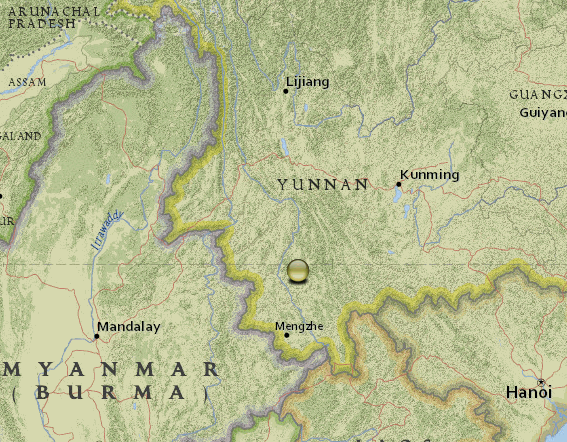
couple of big quakes in China
Yunnan Pu'er Jinggu Dai and Yi Autonomous County
Mag, Type, Date, Time, Lat, Long, Depth
5.8 Ms, 6/12/2014, 02:43:45, 23.3, 100.5, 9
3.4 Ms, 6/12/2014, 02:45:21, 23.3, 100.5, 7
3.2 Ms, 6/12/2014, 02:46:43, 23.3, 100.5, 5
4.4 Ms, 6/12/2014, 02:50:05, 23.3, 100.5, 5
3.1 Ms, 6/12/2014, 03:49:27, 23.3, 100.5, 9
3.1 Ms, 6/12/2014, 03:54:20, 23.3, 100.5, 10
5.9 Ms, 6/12/2014, 18:20:00, 23.3, 100.5, 10
if you click the map image below it will go to ikimaps interactive
not quite able to reproduce that map image on ikimaps the same, it zooms right in to the icon, because the quakes are all reported as the same Lat/Long, so you need to click on the zoom out button
edit on
1200000033933914 by muzzy because: (no reason given)
Am I the only one observing quietly???
This was over 5 hours ago!
I guess there is life outside of ATS!
6.0
18km E of Punta de Burica, Panama
2014-12-06 17:21:49 UTC
14.0 km
This was over 5 hours ago!
I guess there is life outside of ATS!
6.0
18km E of Punta de Burica, Panama
2014-12-06 17:21:49 UTC
14.0 km
a reply to: wasobservingquietly
Damn, That was 4am for me. I think I was sleeping. Lol
So no, there is ATS and there is sleep.
lol
P
Damn, That was 4am for me. I think I was sleeping. Lol
So no, there is ATS and there is sleep.
lol
P
WOQ, I stepped out for a few hours and bang a couple of 6's!
prediction is near impossible, the only clue was it was a Full Moon yesterday
2nd one
F-E Region: Banda Sea
Time: 2014-12-06 22:05:13.2 UTC
Magnitude: 6.1
Epicenter: 130.50°E 6.21°S
Depth: 142 km
Status: confirmed
prediction is near impossible, the only clue was it was a Full Moon yesterday
2nd one
F-E Region: Banda Sea
Time: 2014-12-06 22:05:13.2 UTC
Magnitude: 6.1
Epicenter: 130.50°E 6.21°S
Depth: 142 km
Status: confirmed
earthquake.usgs.gov...
M6.8
119km W of Panguna, Papua New Guinea
Event Time
2014-12-07 01:22:07 UTC
2014-12-07 11:22:07 UTC+10:00 at epicenter
2014-12-06 17:22:07 UTC-08:00 system time
Location
6.500°S 154.400°E depth=10.0km (6.2mi)
Nearby Cities
119km (74mi) W of Panguna, Papua New Guinea
127km (79mi) WSW of Arawa, Papua New Guinea
338km (210mi) SE of Kokopo, Papua New Guinea
485km (301mi) ESE of Kimbe, Papua New Guinea
689km (428mi) WNW of Honiara, Solomon Islands
earthquake.usgs.gov...
M5.2
126km WSW of Panguna, Papua New Guinea
Event Time
2014-12-07 01:40:05 UTC
2014-12-07 11:40:05 UTC+10:00 at epicenter
2014-12-06 17:40:05 UTC-08:00 system time
Location
6.540°S 154.359°E depth=10.0km (6.2mi)
Nearby Cities
126km (78mi) WSW of Panguna, Papua New Guinea
135km (84mi) WSW of Arawa, Papua New Guinea
335km (208mi) SE of Kokopo, Papua New Guinea
479km (298mi) ESE of Kimbe, Papua New Guinea
694km (431mi) WNW of Honiara, Solomon Islands
a reply to: muzzy
Hey Muzzy, when did GeoNet extend their area of coverage?
Hey Muzzy, when did GeoNet extend their area of coverage?
Prov,Date/Time UTC,Latitude,Longitude,Magnitude,Depth(Km),Location
newz,2014-12-02 05:11:31, 6.090, 123.125, 6.2, 614.0, Mindanao. Philippines
newz,2014-11-21 10:10:19, 2.280, 127.050, 6.0, 38.0, Nthn Molucca Sea
newz,2014-11-15 13:40:46, -23.655, -179.058, 5.5, 521.4, South Of Fiji Isls.
newz,2014-11-15 02:31:40, 1.930, 126.550, 6.6, 35.0, Nthn Molucca Sea
newz,2014-11-13 10:42:17, -10.570, 165.630, 5.6, 43.0, Santa Cruz Isls.
newz,2014-11-13 10:24:18, -15.170, 173.050, 5.6, 10.0, Fiji Isls. Region
newz,2014-11-07 03:33:54, -6.040, 148.200, 6.0, 43.0, New Britain Region. P.N.G.
a reply to: PuterMan
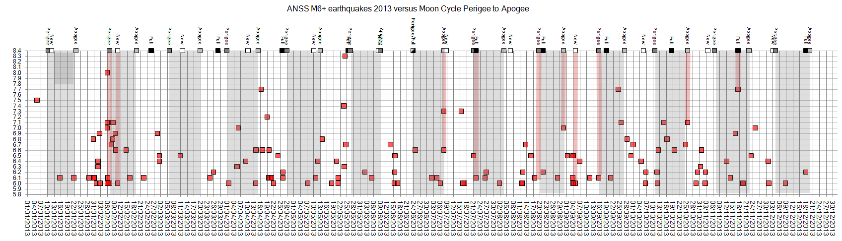
maybe the study was looking at the wrong numbers, could be M5.8 up might show different results, to take allowance for mb to MW conversions etc and the ones that slip below the M6 threshold on review.
I'm not sure I kept the Excel graph, I'll have a look for it.
Another aspect I didn't consider, was if the Moon was pulling away or coming in on the date of the Full Moon, may have an influence,
during this current flurry of M6 quakes, the Moon was pulling away on the full Moon.
There was a small swarm of small quakes at Kawerau, NI, NZ yesterday, thats a Geothermal Field that is tapped for steam for the saw mill there, it pops up every now and again, with no particular reason, wondering if the Moon effects volcanic hot spots too.
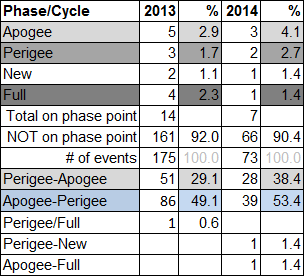
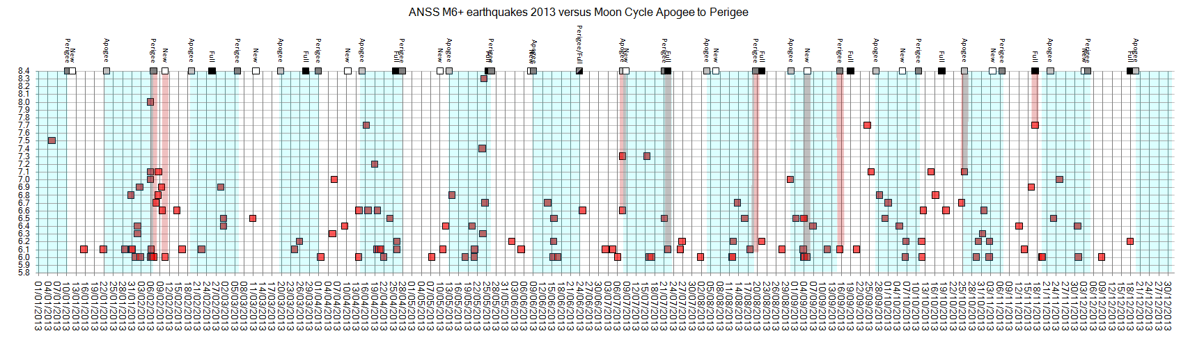
No I didn't save the graph, but just had a quick look at GFZ data M5.8 this year, and in the last 3 months;
last Full Moon was Nov 6 and sure enough there was a M6.6 at New Britain PNG, but then there were another 13 quakes over 5.8 through till Dec6
Oct Full Moon was on the 8th , yes a 6.1 Gulf of California and a 7.0 S East Pacific Rise on the 9th, but also another 8 x M5.8+ quakes through till the Nov6 Full Moon.
Doesn't look like anything has changed.
It must be that by default when there are a series of quakes above M5.8, one goes looking for where the Full Moon is at, and sometimes it does coincide.
Instead of looking at the Full Moon and comparing it to events maybe should be looking at clusters of quakes, for example
15-17/11 there were 5 quakes over 5.8
21-22/11 there were 4 quakes over 5.8
which fits in with the Moon "coming in" 15-27/11
www.fourmilab.ch...
maybe the study was looking at the wrong numbers, could be M5.8 up might show different results, to take allowance for mb to MW conversions etc and the ones that slip below the M6 threshold on review.
I'm not sure I kept the Excel graph, I'll have a look for it.
Another aspect I didn't consider, was if the Moon was pulling away or coming in on the date of the Full Moon, may have an influence,
during this current flurry of M6 quakes, the Moon was pulling away on the full Moon.
There was a small swarm of small quakes at Kawerau, NI, NZ yesterday, thats a Geothermal Field that is tapped for steam for the saw mill there, it pops up every now and again, with no particular reason, wondering if the Moon effects volcanic hot spots too.
edit on 1200000034034014 by muzzy because: (no reason given)
No I didn't save the graph, but just had a quick look at GFZ data M5.8 this year, and in the last 3 months;
last Full Moon was Nov 6 and sure enough there was a M6.6 at New Britain PNG, but then there were another 13 quakes over 5.8 through till Dec6
Oct Full Moon was on the 8th , yes a 6.1 Gulf of California and a 7.0 S East Pacific Rise on the 9th, but also another 8 x M5.8+ quakes through till the Nov6 Full Moon.
Doesn't look like anything has changed.
It must be that by default when there are a series of quakes above M5.8, one goes looking for where the Full Moon is at, and sometimes it does coincide.
Instead of looking at the Full Moon and comparing it to events maybe should be looking at clusters of quakes, for example
15-17/11 there were 5 quakes over 5.8
21-22/11 there were 4 quakes over 5.8
which fits in with the Moon "coming in" 15-27/11
www.fourmilab.ch...
edit on 1200000034034014 by muzzy because: (no reason given)
Lamont-Doherty Earth Observatory (LDEO) detections for the period 01/12 to 07/12/2014 UTC
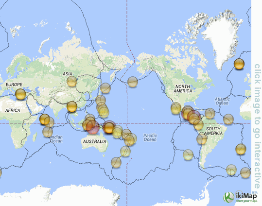
note how the map I made is set on the AntiMeridian, not the Meridian like ikimaps does. Another quirk of ikimaps, being European based.
note how the map I made is set on the AntiMeridian, not the Meridian like ikimaps does. Another quirk of ikimaps, being European based.
edit on
12u34134114 by muzzy because: (no reason given)
Panama just got rocked with another one, this time a 6.7:
earthquake.usgs.gov...
They just had a 6.0 only 10 km from this new spot just two days ago.
This could mean trouble ahead for any of those countries near there- Panama, Costa Rica, Nicaragua, or even Columbia. Those are big quakes, and relatively shallow, less than 15 km deep. And getting bigger it appears.
edit on Mon Dec 8th 2014 by TrueAmerican because: (no reason
given)
a reply to: PuterMan
and further to reply by: muzzy
I couldn't find the posts on QW2014 where this was last discussed, was likely in early June this year I think, based on when I did the graphs.
Here are the graphs again anyway, which I found on my ATS image uploads pages
right click view image for full size
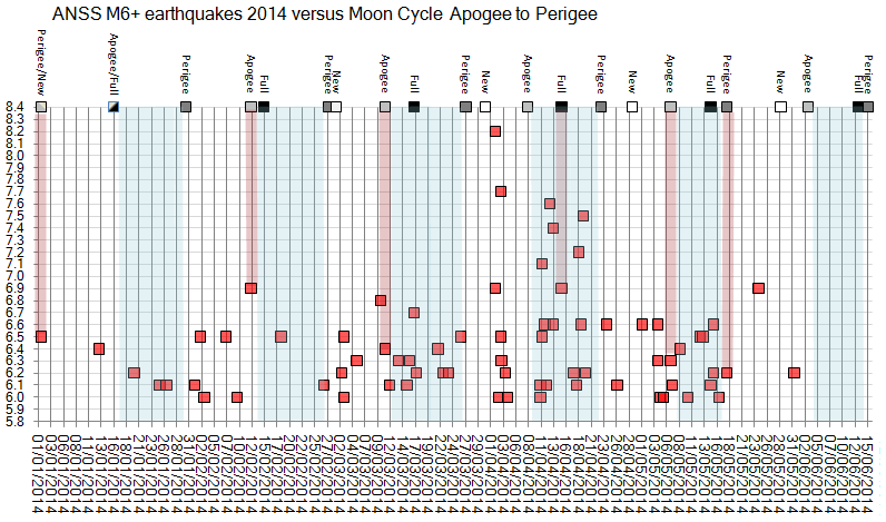
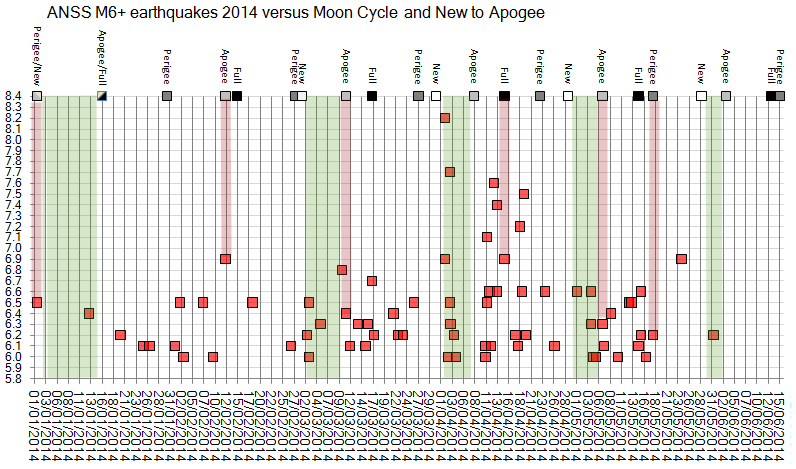
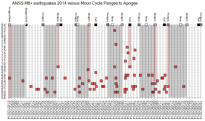
So has anything changed in 6 months?
This last flurry of M6's appears to be quite condensed in time
Will look into it and update the 2014 graphs
and further to reply by: muzzy
I couldn't find the posts on QW2014 where this was last discussed, was likely in early June this year I think, based on when I did the graphs.
Here are the graphs again anyway, which I found on my ATS image uploads pages
right click view image for full size
So has anything changed in 6 months?
This last flurry of M6's appears to be quite condensed in time
Will look into it and update the 2014 graphs
edit on 1200000034134114 by muzzy because: (no reason given)
map based on data from ANSS showing magnitude 6+ earthquakes in the Panama Fracture Zone region 1962-2014
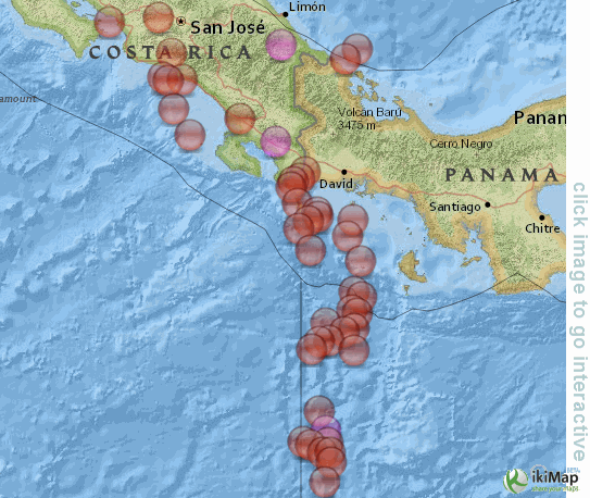
largest 22/04/1991 21:56:52, 9.685, -83.073, 10, 7.6Ms, S of Limon, Costa Rica
geez, there may be a few minor faults with this ikimaps, but getting views isn't a problem, by the time I posted the map there then came on to ATS to post the map/link and went back to ikimaps to get the link url address it already had 6 visits.
I'm liking the National Geographic Map for the static images, has the undersea terrain without being too dark (like Google Satellite) and the icons stand out quite well. ikimaps doesn't have it available for interactivity though, I get it through GPS Visualiser.
largest 22/04/1991 21:56:52, 9.685, -83.073, 10, 7.6Ms, S of Limon, Costa Rica
edit on 1200000034134114 by muzzy because: (no reason given)
' geez, there may be a few minor faults with this ikimaps, but getting views isn't a problem, by the time I posted the map there then came on to ATS to post the map/link and went back to ikimaps to get the link url address it already had 6 visits.
I'm liking the National Geographic Map for the static images, has the undersea terrain without being too dark (like Google Satellite) and the icons stand out quite well. ikimaps doesn't have it available for interactivity though, I get it through GPS Visualiser.
edit on 1200000034134114 by
muzzy because: (no reason given)
new topics
-
Egypt to join South Africa genocide case at ICJ
Middle East Issues: 2 hours ago -
Kingdom of the Planet of the Apes
Movies: 5 hours ago -
Jean Michel and Brian May Live from Bratislava
General Chit Chat: 10 hours ago
top topics
-
Trump Record Breaking Campaign Rally 5/11 in New Jersey Draws 100,000 People
2024 Elections: 14 hours ago, 14 flags -
Biden Withholding Sensitive US Intelligence on Hamas Leaders From Israel
US Political Madness: 14 hours ago, 10 flags -
Anybody else go to the movie theater a lot? Have you noticed how dead they are?
General Chit Chat: 14 hours ago, 7 flags -
something falls in Canada
Aliens and UFOs: 15 hours ago, 5 flags -
Iranian Lawmaker Declares Iran Has Nuclear Weapons
Mainstream News: 12 hours ago, 5 flags -
Jean Michel and Brian May Live from Bratislava
General Chit Chat: 10 hours ago, 5 flags -
US mistakes in assessing the military potential of China and Russia
ATS Skunk Works: 17 hours ago, 4 flags -
Egypt to join South Africa genocide case at ICJ
Middle East Issues: 2 hours ago, 2 flags -
Kingdom of the Planet of the Apes
Movies: 5 hours ago, 1 flags
active topics
-
Bibi’s Dilemma
Middle East Issues • 271 • : yuppa -
Anybody else go to the movie theater a lot? Have you noticed how dead they are?
General Chit Chat • 20 • : 777Vader -
Is there a dependence on the number of children in the family and its well-being?
New World Order • 44 • : chr0naut -
Egypt to join South Africa genocide case at ICJ
Middle East Issues • 12 • : CriticalStinker -
-@TH3WH17ERABB17- -Q- ---TIME TO SHOW THE WORLD--- -Part- --44--
Dissecting Disinformation • 955 • : brewtiger123 -
Kingdom of the Planet of the Apes
Movies • 12 • : chr0naut -
Biden Withholding Sensitive US Intelligence on Hamas Leaders From Israel
US Political Madness • 52 • : 777Vader -
REAL ID now a reality
General Conspiracies • 51 • : TheMisguidedAngel -
A new Why Files How CRISPR and AI Destroy the World
Science & Technology • 19 • : charlest2 -
President Bidens Health is Declining Faster 5.8.2024 - He Should Stay Home.
2024 Elections • 50 • : doubledan717