It looks like you're using an Ad Blocker.
Please white-list or disable AboveTopSecret.com in your ad-blocking tool.
Thank you.
Some features of ATS will be disabled while you continue to use an ad-blocker.

Hi, new guy here with some screenshots of something weird I found on google maps!
page: 3share:
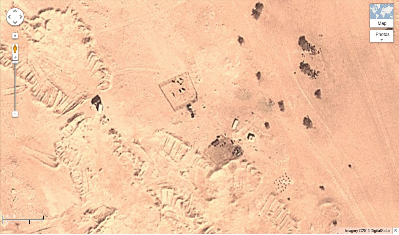
I'm pretty sure this is an old military camp:
www.moonofalabama.org...
Notice the similarities with the photo above. It could be an old AA, or arty emplacement.
Here is an old thread with some more images:
www.abovetopsecret.com...
www.moonofalabama.org...
Notice the similarities with the photo above. It could be an old AA, or arty emplacement.
Here is an old thread with some more images:
www.abovetopsecret.com...
Maybe these are deception complexes used in the gulf war
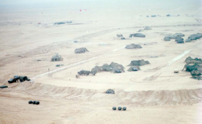
Aerial views of deception complex simulating corps, divisional and brigade headquarters; overview. XVIII Airborne Corps deception effort to cover redeployment of corps to west in Phase II of Operation DESERT STORM, Eastern Province, Saudi Arabia
Zarniwoop
Maybe these are deception complexes used in the gulf war
Aerial views of deception complex simulating corps, divisional and brigade headquarters; overview. XVIII Airborne Corps deception effort to cover redeployment of corps to west in Phase II of Operation DESERT STORM, Eastern Province, Saudi Arabia
That could be it!
whitewave
Middle East version of crop circles? I can't imagine these images would stay long in a wind-swept sandy environment.
Oh, and welcome to the site.
Picture #5 is definitely what looks like the remains of a village or town fortified with a wall. The whole complex would have been built on top of bedrock, and all those lines are where wooden or stone walls were placed.
Perhaps the three sides shapes are where animals were kept.
I suspect many of these sites are military in origin but dating from different conflicts the 1991 gulf war WW2 or WW1 if not even older.
Different areas of desert weather differently remember the pictures of the WW2 fighter found in the Sahara desert last year? you can find ancient spear points in the desert on the surface in deserts.
Think about the Nazca lines in Peru which have lasted around 1500 years not all deserts create dunes etc some are very static.
upload.wikimedia.org...
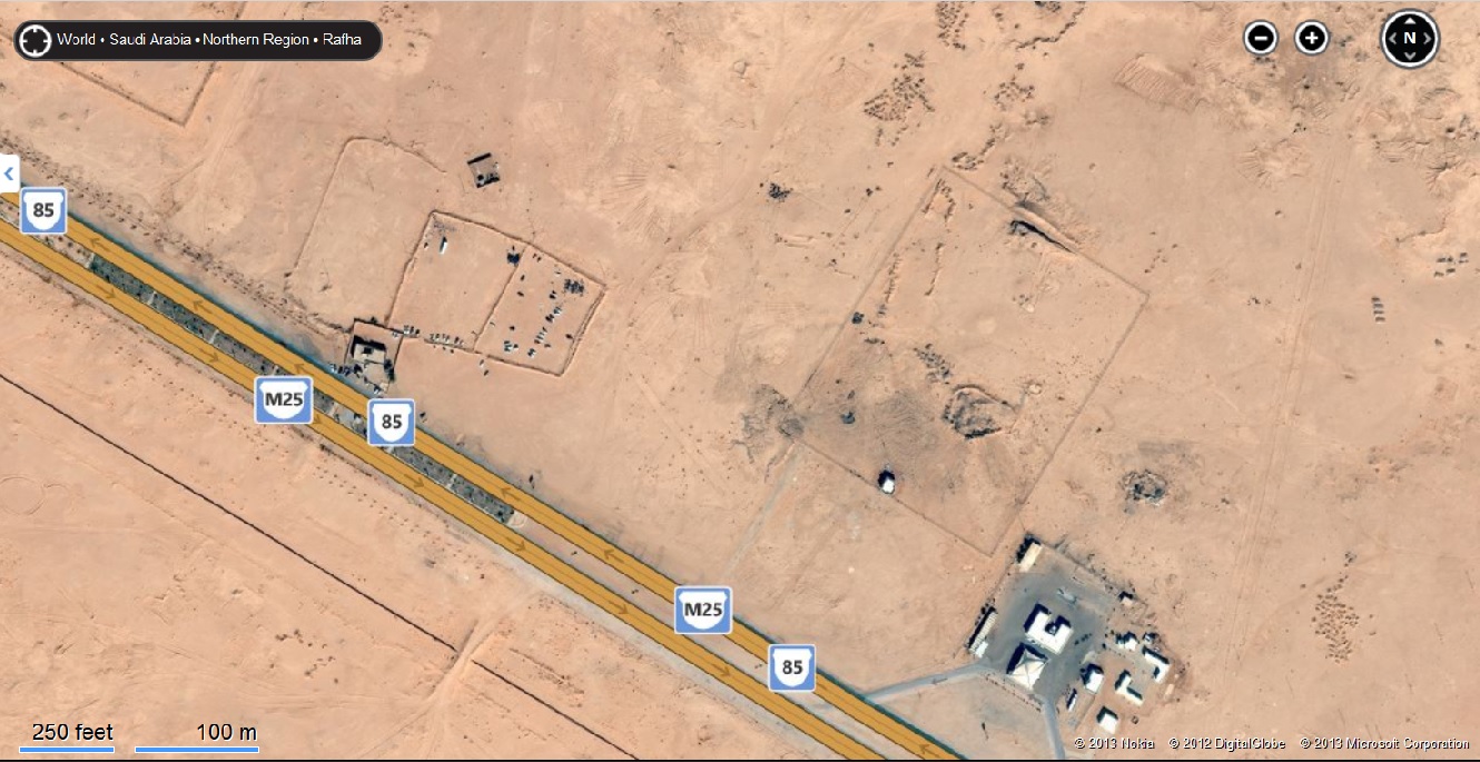
Seems 101st Airborne was based there in Desert Storm according to above.
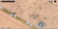
Google map to see location to compare with above map.
goo.gl...
Seems this photo says it was a Decoy?
Aerial views of deception complex simulating corps, divisional and brigade headquarters; overview. XVIII Airborne Corps deception effort to cover redeployment of corps to west in Phase II of Operation DESERT STORM, Eastern Province, Saudi Arabia, north of Trans-Arabian Pipeline ("Tapline") Road and east of King Khalid Military City. 22 January 1991, XVIII Airborne Corps History Office photograph by PFC John F. Freund, DS-F-131-10.
Decoy 101st Airborne Division command post, DESERT STORM
www.history.army.mil...
www.history.army.mil...
Seems 101st Airborne was based there in Desert Storm according to above.
Google map to see location to compare with above map.
goo.gl...
Seems this photo says it was a Decoy?
Aerial views of deception complex simulating corps, divisional and brigade headquarters; overview. XVIII Airborne Corps deception effort to cover redeployment of corps to west in Phase II of Operation DESERT STORM, Eastern Province, Saudi Arabia, north of Trans-Arabian Pipeline ("Tapline") Road and east of King Khalid Military City. 22 January 1991, XVIII Airborne Corps History Office photograph by PFC John F. Freund, DS-F-131-10.
Decoy 101st Airborne Division command post, DESERT STORM
www.history.army.mil...
www.history.army.mil...
edit on 2-12-2013 by JBA2848 because: (no reason given)
JBA2848
upload.wikimedia.org...
Seems 101st Airborne was based there in Desert Storm according to above.
Google map to see location to compare with above map.
goo.gl...
Seems this photo says it was a Decoy?
Aerial views of deception complex simulating corps, divisional and brigade headquarters; overview. XVIII Airborne Corps deception effort to cover redeployment of corps to west in Phase II of Operation DESERT STORM, Eastern Province, Saudi Arabia, north of Trans-Arabian Pipeline ("Tapline") Road and east of King Khalid Military City. 22 January 1991, XVIII Airborne Corps History Office photograph by PFC John F. Freund, DS-F-131-10.
Decoy 101st Airborne Division command post, DESERT STORM
www.history.army.mil...
www.history.army.mil...
edit on 2-12-2013 by JBA2848 because: (no reason given)
Good work!
reply to post by Anomaly84
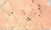
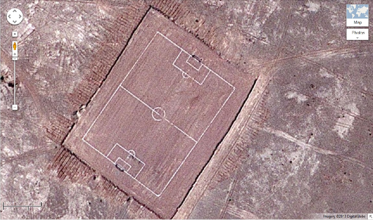
Looks like they're all over the region. I don't think they are anything that hasn't been found or are unknown of. Saudi Arabia is pretty aware of what they have in their territory. And they don't look ancient, the structures look more or less like they were made with tractors or something that can push dirt or sand.
If you want something interesting to look into that is in Saudi Arabia, look up Mt. Jebel Al Lawz. You'll wonder why Saudi Arabia is hiding everything they know about this mountain.
reply to post by Anomaly84
Look at that, your thread is now the number one thread on the main page. Nice work noob!
Look at that, your thread is now the number one thread on the main page. Nice work noob!
They appear to be ancient markings of some sort.
Has anyone found out for sure what they are yet ?
I've heard Saudi Arabia has graveyards in the desert
with many giants buried there.
Oh ya and welcome to ATS.
Has anyone found out for sure what they are yet ?
I've heard Saudi Arabia has graveyards in the desert
with many giants buried there.
Oh ya and welcome to ATS.
edit on 2-12-2013 by randyvs because: (no reason given)
Looking at the picture where you can see the entire layout, I was reminded of a similar jumbled layout of foxholes and defensive positions located in
the Ardennes, left over from the Ardennes Offensive at the end of WWII. Fighting positions established to counter an assault from all directions,
since you don't know where the enemy is coming from.
Anyway, that is the first thing I thought of. And if you look at some of the pictures, it appears that these are manmade structures, and not natural formations of any kind. Also, since the region has a large military presence, my guess would be that these are fighting positions of some kind. Whether they were for training, or actual combat I do not know though.
If that is not the right answer, then maybe they are the remains of something ancient. I am not sure if that could be correct, but I cannot really think of anything else that is feasible. If there were some other structures around, something that would hint at what could possibly have gone on there, such as a factory or something, the answer would be easier. But I will have to go with my initial reaction and say these are military related.
They appear to be completely natural and normal rock formations, just like all the rock formations on mars,nothing out of the ordinary
[sarcasm off]
I remember seeing a thread here on ATS with very similar looking things,in egypt I think it was, and they turned out to be an old world war 2 bombing range.
[sarcasm off]
I remember seeing a thread here on ATS with very similar looking things,in egypt I think it was, and they turned out to be an old world war 2 bombing range.
You guys are silly.
They're off-road car rally courses for female drivers.
oh wait.
But seriously, looks like old encampments. Interesting stuff!
They're off-road car rally courses for female drivers.
oh wait.
But seriously, looks like old encampments. Interesting stuff!
I see someone again posted that these are ancient sites. My post from the first page is pretty conclusive. These features can be seen all over the
place, and match exactly the pattern left behind by modern heavy machinery.
www.abovetopsecret.com...
These are definitely modern. A lot of active settlements in the area mimic the chaotic layout seen at this site. I think it's just expansion in progress, or abandoned building sites.
www.abovetopsecret.com...
I can be pretty sure that these aren't ancient, because some features are cut around the vehicle tracks [which are obviously modern] such as this one - 29.495582,43.905991. This feature is a particularly good example - 29.494226,43.902295 - because it shows the tell tale signs of heavy machinery. Something was in there digging a hole. Check out the city of rahfa. 29.599212,43.559857 Here you can see the same patterns as the 'mystery' site. Just marks from heavy machinery. Here is another similar site nearby, mere feet from the highway. 29.47972,43.789835. Same distinct patterns. If you follow along the highway south of the site, you'll see countless examples of this sort of excavation.
These are definitely modern. A lot of active settlements in the area mimic the chaotic layout seen at this site. I think it's just expansion in progress, or abandoned building sites.
edit on 2-12-2013 by LeviWardrobe because: (no reason given)
If I was just going to throw a guess out, I'd say some of them have to do with oil wells/exploration. If you check out google maps near
midland/odessa tx, you will see some pretty goofy looking markings on the ground.
they are definitely not ancient... it has the look of surface stripping or the technique used looking for oil.
the area lies between Rafha and Hafar Al-Batin and there are plenty of fences erected around some of the squared off slightly raised looking areas... the dark splotches appear to be vegetation.
try the birds eye views here, select the Geohack coordinates to the right on this wiki page.
en.wikipedia.org...
edit on nd025413p0900000054R02 by SisyphusRide because: (no reason given)
new topics
-
President BIDEN's FBI Raided Donald Trump's Florida Home for OBAMA-NORTH KOREA Documents.
Political Conspiracies: 2 hours ago -
Maestro Benedetto
Literature: 3 hours ago -
Is AI Better Than the Hollywood Elite?
Movies: 3 hours ago -
Las Vegas UFO Spotting Teen Traumatized by Demon Creature in Backyard
Aliens and UFOs: 7 hours ago -
2024 Pigeon Forge Rod Run - On the Strip (Video made for you)
Automotive Discussion: 8 hours ago -
Gaza Terrorists Attack US Humanitarian Pier During Construction
Middle East Issues: 8 hours ago -
The functionality of boldening and italics is clunky and no post char limit warning?
ATS Freshman's Forum: 9 hours ago -
Meadows, Giuliani Among 11 Indicted in Arizona in Latest 2020 Election Subversion Case
Mainstream News: 10 hours ago -
Massachusetts Drag Queen Leads Young Kids in Free Palestine Chant
Social Issues and Civil Unrest: 10 hours ago -
Weinstein's conviction overturned
Mainstream News: 11 hours ago
top topics
-
President BIDEN's FBI Raided Donald Trump's Florida Home for OBAMA-NORTH KOREA Documents.
Political Conspiracies: 2 hours ago, 17 flags -
Krystalnacht on today's most elite Universities?
Social Issues and Civil Unrest: 13 hours ago, 9 flags -
University of Texas Instantly Shuts Down Anti Israel Protests
Education and Media: 16 hours ago, 8 flags -
Supreme Court Oral Arguments 4.25.2024 - Are PRESIDENTS IMMUNE From Later Being Prosecuted.
Above Politics: 13 hours ago, 8 flags -
Weinstein's conviction overturned
Mainstream News: 11 hours ago, 7 flags -
Massachusetts Drag Queen Leads Young Kids in Free Palestine Chant
Social Issues and Civil Unrest: 10 hours ago, 7 flags -
Gaza Terrorists Attack US Humanitarian Pier During Construction
Middle East Issues: 8 hours ago, 7 flags -
Meadows, Giuliani Among 11 Indicted in Arizona in Latest 2020 Election Subversion Case
Mainstream News: 10 hours ago, 5 flags -
Las Vegas UFO Spotting Teen Traumatized by Demon Creature in Backyard
Aliens and UFOs: 7 hours ago, 4 flags -
2024 Pigeon Forge Rod Run - On the Strip (Video made for you)
Automotive Discussion: 8 hours ago, 3 flags
active topics
-
Massachusetts Drag Queen Leads Young Kids in Free Palestine Chant
Social Issues and Civil Unrest • 14 • : ToneD -
President BIDEN's FBI Raided Donald Trump's Florida Home for OBAMA-NORTH KOREA Documents.
Political Conspiracies • 6 • : pianopraze -
British TV Presenter Refuses To Use Guest's Preferred Pronouns
Education and Media • 169 • : WakeUpBeer -
Is AI Better Than the Hollywood Elite?
Movies • 11 • : rickymouse -
Supreme Court Oral Arguments 4.25.2024 - Are PRESIDENTS IMMUNE From Later Being Prosecuted.
Above Politics • 83 • : Sookiechacha -
Sol Et Luna - TIME2024
Short Stories • 10 • : BrotherKinsMan -
University of Texas Instantly Shuts Down Anti Israel Protests
Education and Media • 263 • : cherokeetroy -
Gaza Terrorists Attack US Humanitarian Pier During Construction
Middle East Issues • 26 • : nugget1 -
Manly P. Hall says Freemasonry is a religion?
Secret Societies • 22 • : Therealbeverage -
One Flame Throwing Robot Dog for Christmas Please!
Weaponry • 11 • : Therealbeverage