It looks like you're using an Ad Blocker.
Please white-list or disable AboveTopSecret.com in your ad-blocking tool.
Thank you.
Some features of ATS will be disabled while you continue to use an ad-blocker.

Amazing Images From Mars (Mars Express, ESA)
page: 2share:
UpEndedWorld
VoidHawk
NoRulesAllowed
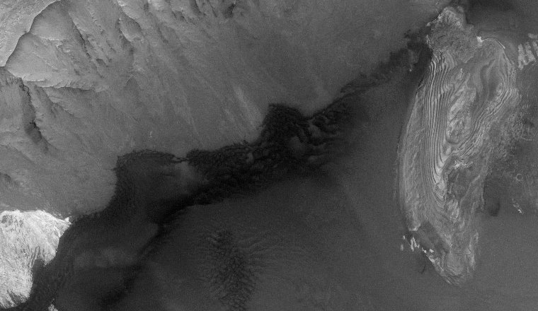
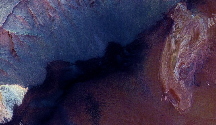
A square crater?
Indeed! Someone needs to prove that this is not a computer generated rendering,
similar to those used in manys a sci-fi movie!
NASA are not to be trusted. Simple as!edit on 11/10/2013 by UpEndedWorld because: format
You could've read this thread, but I'll reiterate it just for you:
1. It is a computer generated rendering, but it uses the real image data from Mars (albeit false-colour), with real elevation data from the same area of Mars. It's not that different from how you can explore the Earth's mountains and valleys in Google Earth.
2. This is not from NASA, but from the European Space Agency (ESA).
But it's not a square crater anyway, it's just the way the eroded walls of the canyon came to be.
UpEndedWorld
VoidHawk
NoRulesAllowed
A square crater?
Indeed! Someone needs to prove that this is not a computer generated rendering,
similar to those used in manys a sci-fi movie!
NASA are not to be trusted. Simple as!edit on 11/10/2013 by UpEndedWorld because: format
Maybe there is also an impact crater component to that terrain, but I think it looks like a canyon. Perhaps the canyon can sometime after the nearby crater rim was produced.
And square canyons are not terribly uncommon. Here is one I found near the Grand Canyon here on Earth:
edit on 10/11/2013 by Soylent Green Is People because: (no reason given)
abeverage
Looks like a WHOLE lot of water had eroded those canyon walls.
That sure looks apparent.
Or any liquid - carbon dioxide, methane. Get the temperature cool enough and any gas will condense onto rock, then more gas will cool down and liquify onto what is already there. In the end, there's an ice crystal which then melts again and the liquid goes downhill before evaporating and repeating the cycle.
reply to post by stormcell
In this case it was most probably water. It's well established that Mars had liquid water in abundance billions of years ago.
Mars doesn't get cold enough for liquid methane and liquid CO2 requires high atmospheric pressure.
In this case it was most probably water. It's well established that Mars had liquid water in abundance billions of years ago.
Mars doesn't get cold enough for liquid methane and liquid CO2 requires high atmospheric pressure.
edit on 10/11/2013 by Phage because: (no
reason given)
Even though the Mars image canyon is not a "square crater", such square-ish craters do exist, even on Earth.
One of them being the famous "Barringer Crater" outside of Flagstaff, Arizona.
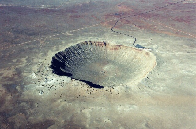
It is basically a square with rounded corners.
One of them being the famous "Barringer Crater" outside of Flagstaff, Arizona.
It is basically a square with rounded corners.
edit on 12-10-2013 by charlyv because: content
AthlonSavage
reply to post by NoRulesAllowed
This just proves that Nasa takes hugh definition pictures of Mars and that they are very careful for which ones they give out the public
they are very careful for which ones they give out the public
Yes they are, if they can take high definition pictures of Mars why not the moon as these pictures of mars? are they hiding something they dont want us to know on what it is?
Agent_USA_Supporter
AthlonSavage
reply to post by NoRulesAllowed
This just proves that Nasa takes hugh definition pictures of Mars and that they are very careful for which ones they give out the public
they are very careful for which ones they give out the public
Yes they are, if they can take high definition pictures of Mars why not the moon as these pictures of mars? are they hiding something they dont want us to know on what it is?
NASA's Lunar Reconnaissance Orbiter (LRO) took hrgh-res images that had a resolution of up to 30 cm per pixel. That means objects a little larger than the size of a basketball could be resolved. That's pretty darn good, and equal to the camera on the MRO (Mars Reconnaissance Orbiter).
Both the LRO camera (LROC) and the MRO camera ("HiRISE") are equal to or better than images taked from Earth satellites for sites like "Google Earth". The more up-close detailed images of the Earth on "Google Earth" are from airplanes -- not satellites.
LRO:
The Lunar Reconnaissance Orbiter Camera
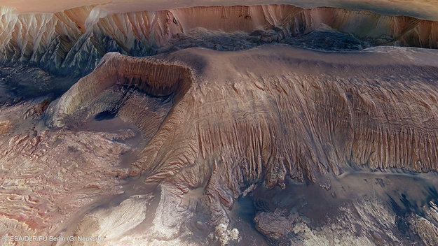
It should again be pointed out the the image from the ESA in the OP of this thread is NOT a "true picture", but has been computer manipulated. The manipulation statrs by building a 3D computer-generated model of the terrain using elevation data. Then the real image is overlaid on top of the CGI terrain, and then false color added. Then the viewing angle of that computer-generated terrain with the image on top is manipulated by turning the CGI 3D model in the computer, to veiw it at more of a horizontal angle.
So the Mars image in the OP is heavily computer-manipulated.
edit on 10/12/2013 by Soylent Green Is People because: (no reason given)
reply to post by VoidHawk
I know Nature abhors straight lines, but those look like two 90degree angles to me. Very odd. Could be an outflow vent of some sort. Geology is not one of my strong points, will let others with more knowledge chime in.
I know Nature abhors straight lines, but those look like two 90degree angles to me. Very odd. Could be an outflow vent of some sort. Geology is not one of my strong points, will let others with more knowledge chime in.
Soylent Green Is People
Basically, ESA is constructing a computer-generated 3D model of the terrain, and then they are overlaying the picture on top of it, and adding false color. They then manipulate the 3D model in a computer by turning it so the view is more horizontal.
The High Resolution Stereo Camera (HRSC) has one sensor pointing forward and down at an angle of 18.9º (forward channel), another pointing backward and down at an angle of -18.9º (same angle, opposite direction the backward channel), and another one pointing down (the nadir channel). With these 3 they can make a 3D model of the scene. The camera also has two more sensors pointing forward and backward (at a different angle), the photometry channels, to get brightness values for the terrain.
Besides those the camera also has four colour channels (all the above mentions channels are panchromatic, meaning that they get all the colours in a greyscale image), a red, a green, a blue and a near infrared channel.
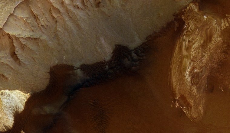
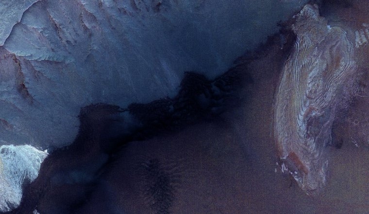
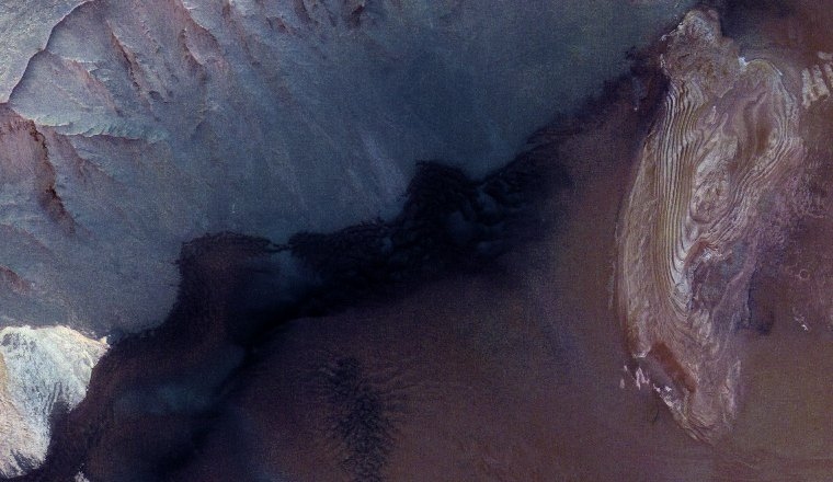
ESA (or the ones working with the HRSC data, I think it's the University of Berlim) usually use the nadir image with superimposed red, green and blue images to make a colour image.
wildespace
Since those images from ESA are false-colour, here's a true-colour (RGB) image from MRO's HiRISE camera, at 25 cm/pixel resolution:
In fact, it's exactly the opposite: the images from ESA's HRSC are (approximate) true colour, made with images from red, green and blue channels, the images from HiRISE are false colour, as HiRISE only has a red, an infrared and a green+blue channel.
ArMaP
wildespace
Since those images from ESA are false-colour, here's a true-colour (RGB) image from MRO's HiRISE camera, at 25 cm/pixel resolution:
In fact, it's exactly the opposite: the images from ESA's HRSC are (approximate) true colour, made with images from red, green and blue channels, the images from HiRISE are false colour, as HiRISE only has a red, an infrared and a green+blue channel.
Thanks for the info, I thought on ESA's images sand looks too blue to be true-colour. Does it say anywhere which fiters were used for those images?
How do they make HiRISE RGB images out of red and green+blue channels, I wonder?
CGI. To me, whatever anyone here says, these pictures are computer generated. In other words, not pictures of Mars terrain.
100% fake. But those calf sucking on NASA's teets, they will drool over anything NASA 'releases' .. And still not get pissed that they take billions of tax payers dollars year after year..
I cant believe people fall for this sh*t...
100% fake. But those calf sucking on NASA's teets, they will drool over anything NASA 'releases' .. And still not get pissed that they take billions of tax payers dollars year after year..
I cant believe people fall for this sh*t...
covertpanther
CGI. To me, whatever anyone here says, these pictures are computer generated. In other words, not pictures of Mars terrain.
The perspective view is computer generated, and that's no secret.
100% fake.
Why?
But those calf sucking on NASA's teets, they will drool over anything NASA 'releases' .. And still not get pissed that they take billions of tax payers dollars year after year..
This is from ESA, not NASA.
I cant believe people fall for this sh*t...
OK, save us from our ignorance and explain why this is 100% fake.
covertpanther
CGI. To me, whatever anyone here says, these pictures are computer generated. In other words, not pictures of Mars terrain.
100% fake. But those calf sucking on NASA's teets, they will drool over anything NASA 'releases' .. And still not get pissed that they take billions of tax payers dollars year after year..
I cant believe people fall for this sh*t...
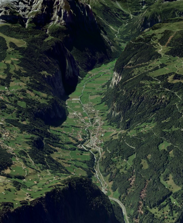
Ooookay... Here's a screenshot from Google Earth, showing the Lauterbrunnen valley in Switzerland. It's real aerial imagery, stretched over real elevation data, so that an oblique view like this can be generated. Are you saying this is not a picture of Earth terrain?
And as has been said for the n-th time in this thread (if you ever bother to read the posts), those pictures are from the European Space Agency (ESA), not from NASA.
But I guess you're here only to make a blind stab at NASA, and aren't really interested in what's really being shown and discussed here. *sigh*
wildespace
Thanks for the info, I thought on ESA's images sand looks too blue to be true-colour. Does it say anywhere which fiters were used for those images?
The best way is using the HRSCview data explorer, although it looks like the explanation they have is for the old version, so that's the one I used.
In that site they have several ways of showing the images, according to the different data.
The nadir image, greyscsale.
The Mars-like version. According to their explanation, "a predefined stretch intended to give an approximation to the colours which might be observed at the surface"
The raw image, "each colour channel presented as captured by the camera".
The stretched, with "each colour channel stretched independently".
The enhanced, with "each colour channel stretched independently and then squared, to enhance colour differences".
It also has a "Substitute IR" box, selecting it recreates the images but with the IR channel instead of the red, so you can have IR versions of all the colour images.
How do they make HiRISE RGB images out of red and green+blue channels, I wonder?
They have a PDF on their site explaining it (in a slightly confusing way), here. From that PDF:
3-color image consisting of RED, BG, and synthetic blue images. The BG image has been warped to line up with the RED.NOMAP image. The BG (blue-green) bandpass primarily accepts green light. The synthetic blue image digital numbers (DNs) consist of the BG image DN multiplied by 2 minus 30% of the RED image DN for each pixel. This is not unique data, but provides a more appealing way to display the color variations present in just two bandpasses, RED and BG.
Ahn... I'm new here and I don't wanna start any arguments but I suggest you all to zoom in the center of the plateau and you shall see 90° angles
and perfectly round circles. In the picture that shows the "lake" (first image).
But tbh what impressed me the most in this image (besides the resolution of course) was that stream of that dark blue liquid. I found it amazing to see something resembling a river and a lake on another planet. I know they've found water there already, but up till now I only heard of it being underground. That liquid clearly isn't. Not that it is water either.
Actually that crater looks like a volcano that spilled over. You can even see something that resembles solidified lava on the on the second image. Does anyone know the ebullition point of sulfur? Cause it might be it, if that valley is cold enough to keep it in liquid state.
reply to post by TBrains
www.universetoday.com...
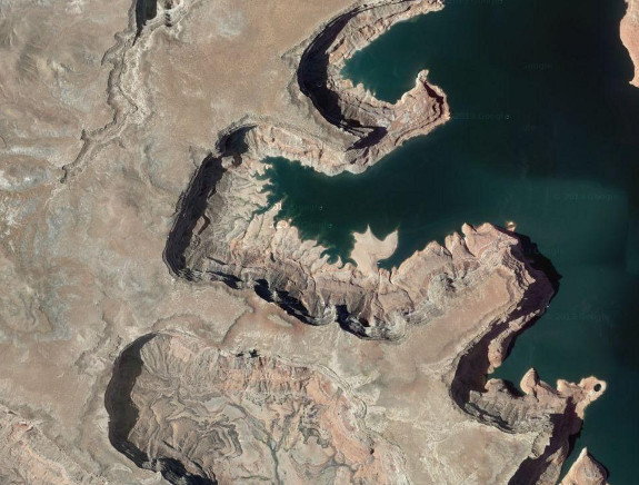
If you look at the original, overhead, image, you can see that they aren't 90º angles. But yes, impact craters are often quite round.
I'm new here and I don't wanna start any arguments but I suggest you all to zoom in the center of the plateau and you shall see 90° angles and perfectly round circles.
Or avalanche material.
But tbh what impressed me the most in this image (besides the resolution of course) was that stream of that dark blue liquid.
www.universetoday.com...
edit on 10/13/2013 by Phage because: (no reason given)
Phage
reply to post by TBrains
If you look at the original, overhead, image, you can see that they aren't 90º angles. But yes, impact craters are often quite round.
I'm new here and I don't wanna start any arguments but I suggest you all to zoom in the center of the plateau and you shall see 90° angles and perfectly round circles.
Or avalanche material.
But tbh what impressed me the most in this image (besides the resolution of course) was that stream of that dark blue liquid.
www.universetoday.com...
edit on 10/13/2013 by Phage because: (no reason given)
Like I said, I didn't mean to start anything, it was just something I noticed. I just can't turn off my Chariot of the Gods vibe
And avalanches happen with volcanic matter too yes? I forgot what the phenomenon is actually called. That thing when an explosion is so big or there's too much magma and it's heavy and the side of the volcano collapses.
I don't know, those "waves" had a certain magma flow vibe to me.
Besides, it it meant to have been the bottom of the ocean yes? Hard to think of an ice avalanche there. Maybe a landslide then?
Either way, I am dying to know what that lake is made off. Hell for all we know it can be oil. Can you imagine the chaos it would be to get there first?
EDIT: The angles still look straight to me, but I do agree that craters often look very round. It just looked like the angles were leading to the craters and my mind went wild hahaha. I know this is not the right forum to discuss it, however. I just meant to point it out.
But like I said, the geological implications of the picture are what I'm fascinated about right now.
edit on 13-10-2013 by TBrains because: (no
reason given)
reply to post by TBrains
www.thefreedictionary.com...
That would be awfully expensive oil by the the time you get to Mars and bring it back.
An avalanche is a fall of any material; rocks, sand, ice.
Maybe a landslide then?
www.thefreedictionary.com...
For all we know it's dust.
Either way, I am dying to know what that lake is made off. Hell for all we know it can be oil. Can you imagine the chaos it would be to get there first?
That would be awfully expensive oil by the the time you get to Mars and bring it back.
edit on 10/13/2013 by Phage because: (no reason given)
covertpanther
CGI. To me, whatever anyone here says, these pictures are computer generated. In other words, not pictures of Mars terrain.
100% fake. But those calf sucking on NASA's teets, they will drool over anything NASA 'releases' .. And still not get pissed that they take billions of tax payers dollars year after year..
I cant believe people fall for this sh*t...
Yeah, brilliant..... I think you might play too many video games, give the computer back to mom or dad and go to bed!
new topics
-
President BIDEN's FBI Raided Donald Trump's Florida Home for OBAMA-NORTH KOREA Documents.
Political Conspiracies: 4 hours ago -
Maestro Benedetto
Literature: 5 hours ago -
Is AI Better Than the Hollywood Elite?
Movies: 5 hours ago -
Las Vegas UFO Spotting Teen Traumatized by Demon Creature in Backyard
Aliens and UFOs: 9 hours ago -
2024 Pigeon Forge Rod Run - On the Strip (Video made for you)
Automotive Discussion: 10 hours ago -
Gaza Terrorists Attack US Humanitarian Pier During Construction
Middle East Issues: 10 hours ago -
The functionality of boldening and italics is clunky and no post char limit warning?
ATS Freshman's Forum: 11 hours ago
top topics
-
President BIDEN's FBI Raided Donald Trump's Florida Home for OBAMA-NORTH KOREA Documents.
Political Conspiracies: 4 hours ago, 25 flags -
Krystalnacht on today's most elite Universities?
Social Issues and Civil Unrest: 15 hours ago, 9 flags -
Supreme Court Oral Arguments 4.25.2024 - Are PRESIDENTS IMMUNE From Later Being Prosecuted.
Above Politics: 15 hours ago, 8 flags -
Weinstein's conviction overturned
Mainstream News: 13 hours ago, 8 flags -
Massachusetts Drag Queen Leads Young Kids in Free Palestine Chant
Social Issues and Civil Unrest: 12 hours ago, 7 flags -
Gaza Terrorists Attack US Humanitarian Pier During Construction
Middle East Issues: 10 hours ago, 7 flags -
Las Vegas UFO Spotting Teen Traumatized by Demon Creature in Backyard
Aliens and UFOs: 9 hours ago, 6 flags -
Meadows, Giuliani Among 11 Indicted in Arizona in Latest 2020 Election Subversion Case
Mainstream News: 12 hours ago, 5 flags -
2024 Pigeon Forge Rod Run - On the Strip (Video made for you)
Automotive Discussion: 10 hours ago, 4 flags -
Is AI Better Than the Hollywood Elite?
Movies: 5 hours ago, 3 flags
active topics
-
Supreme Court Oral Arguments 4.25.2024 - Are PRESIDENTS IMMUNE From Later Being Prosecuted.
Above Politics • 87 • : Sookiechacha -
SHORT STORY WRITERS CONTEST -- April 2024 -- TIME -- TIME2024
Short Stories • 23 • : DontTreadOnMe -
President BIDEN's FBI Raided Donald Trump's Florida Home for OBAMA-NORTH KOREA Documents.
Political Conspiracies • 16 • : Astyanax -
Truth Social goes public, be careful not to lose your money
Mainstream News • 130 • : Astyanax -
Las Vegas UFO Spotting Teen Traumatized by Demon Creature in Backyard
Aliens and UFOs • 11 • : AwakeNotWoke -
Is AI Better Than the Hollywood Elite?
Movies • 13 • : Justoneman -
Hate makes for strange bedfellows
US Political Madness • 47 • : 19Bones79 -
-@TH3WH17ERABB17- -Q- ---TIME TO SHOW THE WORLD--- -Part- --44--
Dissecting Disinformation • 689 • : daskakik -
University of Texas Instantly Shuts Down Anti Israel Protests
Education and Media • 265 • : Astrocometus -
Gaza Terrorists Attack US Humanitarian Pier During Construction
Middle East Issues • 27 • : ToneD