It looks like you're using an Ad Blocker.
Please white-list or disable AboveTopSecret.com in your ad-blocking tool.
Thank you.
Some features of ATS will be disabled while you continue to use an ad-blocker.

Island emerges near Gwadar coast after earthquake
page: 2share:
Here is a likely candidate for the island in the pictures on the news.
Astola Island...
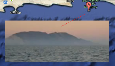
It looks about the right size, right location... it was there prior to yesterday.
Astola Island...
It looks about the right size, right location... it was there prior to yesterday.
reply to post by Zarniwoop
That's really nice detective work.
I have my doubts about a new island of any size popping up some 380 kms from the epicenter of today's quake. (Distance figures provided by member and moderator extraordinaire, JustMike, found here)
Unless it was a submerged island-of-debris of some sort, that was jostled loose from the sea floor and floated to the surface.
ETA: I may have to eat my word, lol. I've found some spotty references to islands formed by mud volcanoes, in the Gwadar, Pakistan area in the past.
2010 story
Malan Island wiki
Interesting..
edit on 9/24/2013 by Olivine because: (no reason given)
reply to post by grey580
Yes. During the Indian Tsunami the ground floor raised some 1,300 feet (if I remember correctly). However, it was still below the surface floor. But it did, however, create a pretty large tsunami.
AAC
Yes. During the Indian Tsunami the ground floor raised some 1,300 feet (if I remember correctly). However, it was still below the surface floor. But it did, however, create a pretty large tsunami.
AAC
This Island should now be a memorial for the people who lost their lives today in Pakistan after the earthquake.
Truly bizarre and scary
M7.4 - PAKISTAN
Preliminary Earthquake Report
Magnitude 7.4
Date-Time
24 Sep 2013 11:29:49 UTC
24 Sep 2013 16:29:49 near epicenter
24 Sep 2013 03:29:49 standard time in your timezone
Location 27.026N 65.521E
Depth 22 km
Distances
69 km (42 mi) NNE of Awaran, Pakistan
118 km (73 mi) NW of Bela, Pakistan
172 km (106 mi) S of Kharan, Pakistan
174 km (107 mi) NW of Uthal, Pakistan
793 km (491 mi) ENE of Muscat, Oman
Location Uncertainty Horizontal: 0.0 km; Vertical 4.7 km
Parameters Nph = 194; Dmin = 874.3 km; Rmss = 1.02 seconds; Gp = 23°
Version =
Event ID us b000jyiv
For updates, maps, and technical information, see: Event Page or USGS Earthquake Hazards Program
National Earthquake Information Center
U.S. Geological Survey
earthquake.usgs.gov...
Eta It's showing as 7.8 on some news sources
edit on 24-9-2013 by violet because: (no reason given)
Zarniwoop
Here is a likely candidate for the island in the pictures on the news.
Reuters is now reporting on it, so there's a somewhat more credible source for you.
Television channels showed images of a stretch of rocky terrain rising above the sea level, with a crowd of bewildered people gathering on the shore to witness the rare phenomenon (Source)
I'm guessing that no one would be milling about "bewildered" if the island had been there yesterday.
reply to post by adjensen
Reuters is merely repeating what the local TV stations reported. They were reporting on it earlier as well.
I agree. But I haven't seen any pictures of people milling about and only a couple blurry pictures of a huge island way off the coast. That seems really strange to me.
My mind is open, it's just leaning one way based on the lack of evidence.
Reuters is now reporting on it, so there's a somewhat more credible source for you.
Reuters is merely repeating what the local TV stations reported. They were reporting on it earlier as well.
I'm guessing that no one would be milling about "bewildered" if the island had been there yesterday.
I agree. But I haven't seen any pictures of people milling about and only a couple blurry pictures of a huge island way off the coast. That seems really strange to me.
My mind is open, it's just leaning one way based on the lack of evidence.
TruthSeekerKnight
reply to post by onehuman
Anyone have information on how deep the sea floor was before the island rose?...
Wouldn't this raise the sea level around the planet? And how much?
Wondering that myself. It must have some effect
It's not on CNN as a big story. I'm wondering if I have a Pakistani channel on my tv I could watch. Are there any videos or better pictures?
Anything on twitter?
From USGS
Tectonic Summary
The September 24, 2013 M7.7 earthquake in south-central Pakistan occurred as the result of oblique-strike-slip type motion at shallow crustal depths. The location and mechanism of the earthquake are consistent with rupture within the Eurasia plate above the Makran subduction zone. The event occurred within the transition zone between northward subduction of the Arabia plate beneath the Eurasia plate and northward collision of the India plate with the Eurasia plate. The epicenter of the event is 69km north of Awaran, Pakistan, and 270km north of Karachi, Pakistan (population 11.6 million).
On a broad scale, the tectonics of southern and central Pakistan reflect a complex plate boundary where the India plate slides northward relative to the Eurasia plate in the east, and the Arabia plate subducts northward beneath the Eurasia plate in the Makran (western Pakistan). These motions typically result in north-south to northeast-southwest strike-slip motion at the latitude of the September 24 earthquake that is primarily accommodated on the Chaman Fault, with the earthquake potentially occurring on one of the southern-most strands of this fault system. Further, more in-depth studies will be required to identify the precise fault associated with this event. Although seismically active, this portion of the Eurasia plate boundary region has not experience large damaging earthquakes in the recent history. In the past 40 years, only one significant event (M6.1), which killed 6, has occurred within 200km of the September 2013 event, in July of 1990.
reply to post by violet
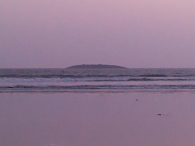
Here's the best picture I've found yet for the island they are saying popped up...
If this is true, it is truly amazing.
Here's the best picture I've found yet for the island they are saying popped up...
If this is true, it is truly amazing.
reply to post by Zarniwoop
Thanks
I was in another duplicate thread that got closed before this and thought I saw videos.
Here's the updated details
Magnitude: 7.7
Location: Pakistan, 66 km NNE of Awaran
Time: Tue, Sep 24, 2013, 4:29:48 AM PDT
GMT: Tue, Sep 24, 2013 11:29:48 GMT
Latitude: 26° 59' 58" N (26.9997°)
Longitude: 65° 30' 51" E (65.5143°)
Depth: 20.0 km
Map: maps.google.com...@26.999700,65.514300&z=6
More Information (while available): earthquake.usgs.gov...
Data provided by US Geological Survey.
--
reply to post by Zarniwoop
I was skeptical too, but according to this 2006 Nature article it has happened previously along the Pakistani coast:
So, not a "rocky" island, as reported earlier today, but a muddy one. It won't be there very long, unless mud continues to erupt.
I was skeptical too, but according to this 2006 Nature article it has happened previously along the Pakistani coast:
In 1945, the Makran earthquake in Pakistan triggered the sudden emergence of three offshore mud volcanoes, and in March 1999 a mud volcano rose out of the water overnight to form Malan Island, 3 kilometres from Pakistan's coast. It is hard to estimate the volume of mud created by such underwater eruptions. And, notes Rice: "Because the extrusion of mud and toxic gas occurs on the seabed it does not threaten human life and does not make the headlines."
So, not a "rocky" island, as reported earlier today, but a muddy one. It won't be there very long, unless mud continues to erupt.
Also, I'd like to know the timeframe... how long did it take for this island to 'pop up' as one of the sources in this thread described. Did it emerge in slo-mo so that onlookers could watch it occuring, or did people just walk outside at some point after the earthquake and go, "Oh, look... an island has risen from the sea due to the previous earthquake." For that matter, is it still rising? Are they sure it's finished?
onehuman
I am also curious as to how far away this was from the epicenter. I mean, would this be a sign of where the pressure relieved itself? I am also curious as to how deep the water is that this arose from.
Also, why didnt it cause a wave shift in the ocean. That seems like a lot of energy to push that thing up.
reply to post by Olivine
That makes a lot more sense. Thanks for posting!
So, not a "rocky" island, as reported earlier today, but a muddy one. It won't be there very long, unless mud continues to erupt.
That makes a lot more sense. Thanks for posting!
reply to post by Dolby_X
I don't think so, as the guy being interviewed says no one has been able to get out to the island... it's apparently 2km off the coast. Could be a video of a similar event in the past, though?
here a video that look like to be film on the island
I don't think so, as the guy being interviewed says no one has been able to get out to the island... it's apparently 2km off the coast. Could be a video of a similar event in the past, though?
S&F Cool story, the earth is always changing.
But watch how the lame stream media will spin this story to support the beating war drum against Pakistan. I can see the talking head spewing "The United States fears for its national security as Pakistan has begun building a land bridge to attack America...."
Like I said this is exciting REAL news and a breath of fresh air from the sewage stream of the MSM.
Dolby_X
here a video that look like to be film on the island
Great. A new island and 7 hours later it is already a new fanatic Islamic country.
Zarniwoop
reply to post by violet
Here's the best picture I've found yet for the island they are saying popped up...
If this is true, it is truly amazing.
If that's actually the island, then they have their distance estimates wrong. That is no way 350 feet from shore, as the sources state.
Talking to Geo news, the DIG said that the island emerged at a distance of 350 feet in the sea from the Gwadar coast.
My source you ask?: I am a master of depth perception AND I can hit a golf ball 350 feet with my pitching wedge.
edit on
24-9-2013 by iamhobo because: (no reason given)
new topics
-
Big Storms
Fragile Earth: 9 minutes ago -
Where should Trump hold his next rally
2024 Elections: 2 hours ago -
Shocking Number of Voters are Open to Committing Election Fraud
US Political Madness: 3 hours ago -
Gov Kristi Noem Shot and Killed "Less Than Worthless Dog" and a 'Smelly Goat
2024 Elections: 4 hours ago -
Falkville Robot-Man
Aliens and UFOs: 4 hours ago -
James O’Keefe: I have evidence that exposes the CIA, and it’s on camera.
Whistle Blowers and Leaked Documents: 5 hours ago -
Australian PM says the quiet part out loud - "free speech is a threat to democratic dicourse"...?!
New World Order: 6 hours ago -
Ireland VS Globalists
Social Issues and Civil Unrest: 6 hours ago -
Biden "Happy To Debate Trump"
2024 Elections: 7 hours ago -
RAAF airbase in Roswell, New Mexico is on fire
Aliens and UFOs: 7 hours ago
top topics
-
A Warning to America: 25 Ways the US is Being Destroyed
New World Order: 16 hours ago, 21 flags -
Blast from the past: ATS Review Podcast, 2006: With All Three Amigos
Member PODcasts: 9 hours ago, 13 flags -
James O’Keefe: I have evidence that exposes the CIA, and it’s on camera.
Whistle Blowers and Leaked Documents: 5 hours ago, 12 flags -
Australian PM says the quiet part out loud - "free speech is a threat to democratic dicourse"...?!
New World Order: 6 hours ago, 11 flags -
Biden "Happy To Debate Trump"
2024 Elections: 7 hours ago, 10 flags -
Mike Pinder The Moody Blues R.I.P.
Music: 9 hours ago, 8 flags -
What is the white pill?
Philosophy and Metaphysics: 8 hours ago, 6 flags -
Shocking Number of Voters are Open to Committing Election Fraud
US Political Madness: 3 hours ago, 5 flags -
Ireland VS Globalists
Social Issues and Civil Unrest: 6 hours ago, 5 flags -
RAAF airbase in Roswell, New Mexico is on fire
Aliens and UFOs: 7 hours ago, 5 flags
active topics
-
Biden "Happy To Debate Trump"
2024 Elections • 47 • : JadedGhost -
University of Texas Instantly Shuts Down Anti Israel Protests
Education and Media • 312 • : marg6043 -
Gov Kristi Noem Shot and Killed "Less Than Worthless Dog" and a 'Smelly Goat
2024 Elections • 30 • : TheMisguidedAngel -
Big Storms
Fragile Earth • 1 • : lilzazz -
President BIDEN's FBI Raided Donald Trump's Florida Home for OBAMA-NORTH KOREA Documents.
Political Conspiracies • 36 • : BingoMcGoof -
ALERT - U.S. President JOE BIDEN Examined and Found NOT OF SOUND MIND.
2024 Elections • 64 • : WeMustCare -
What is the white pill?
Philosophy and Metaphysics • 19 • : TheDiscoKing -
Krystalnacht on today's most elite Universities?
Social Issues and Civil Unrest • 11 • : TheWoker -
Remember These Attacks When President Trump 2.0 Retribution-Justice Commences.
2024 Elections • 59 • : TzarChasm -
Salvador Dali's Moustaches
People • 29 • : GENERAL EYES