It looks like you're using an Ad Blocker.
Please white-list or disable AboveTopSecret.com in your ad-blocking tool.
Thank you.
Some features of ATS will be disabled while you continue to use an ad-blocker.

Help National Geographic Expedition find ancient Mongolian sites
page: 1share:
Yes, this one's real -- and I think it might be fun to get a team from ATS if folks are interested.
Field Expedition: Mongolia web site
This is a "crowd sourced" project, where you look at high resolution satellite photos and mark things you think are weird or interesting. They will collect the identifications made by lots (and lots) of people and if everyone's marking a structure as "something very strange -- go look!" then that area will be added to the investigation.As
How it works: As you make an identification, the system collects information and gives you feedback ("12 people also saw a road here") and shows you what others' pinned. This kind of feedback helps (though it's not as good as picture tutorials).
What's surprised me is how quickly I've begun to notice subtle features on the satellite images. And faint roads. I wish you had the ability to look at images of landscapes NEXT to the ones being identified... it'd help decide if that wandering thing was a road or a river.
Hey, if you decide to participate, post some screen shots of stuff you find!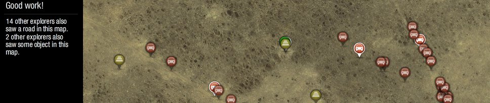
edit on 14-6-2013 by Byrd because:
(no reason given)
The training exercise is NOT as well done as some of these.
After you sign up, you're presented with images to tag. When you finish tagging one area, it presents you with another image. What's NOT as clear is that on the left hand side of the screen after they tell you who else put things there... is that they also tell you why other people identified things as "ancient structures" or "river" or whatever.
So the training isn't as good, but on the other hand, it's fun and a non-stressful way to pass the time.
Edited to add -- WATCH THE VIDEO IN CHROME, NOT FIREFOX. Firefox no like NatGeo movies on my machine.
edit on 13-6-2013 by Byrd
because: (no reason given)
reply to post by Byrd
in other words help them find the ancient Mongolian pirate treasure so that they may keep for themselves
in other words help them find the ancient Mongolian pirate treasure so that they may keep for themselves
edit on 13-6-2013 by Tlexlapoca
because: (no reason given)
edit on 13-6-2013 by Tlexlapoca because: (no reason given)
If I find Eldorado, the lost city of gold or something like that do I get a cut?
Cool gonna sign up and have a go...may as well can't leave the house for a few weeks
Cool gonna sign up and have a go...may as well can't leave the house for a few weeks
Originally posted by boymonkey74
If I find Eldorado, the lost city of gold or something like that do I get a cut?
Cool gonna sign up and have a go...may as well can't leave the house for a few weeks
House arrest, again? What did you do this time?
On topic....sounds like a neat project for a social studies class...is this something I can pass on to my school? Older kids, high school age.
Can I name the place Rabbitville if I find a long lost ruins of some ancient people?
Thanks for the heads up on this. I'll stroll over and have a look see. It sounds like great practice and who knows? If they're asking the public then they haven't eyeballed every foot already and there may well be something out there to find.
Thanks for the heads up on this. I'll stroll over and have a look see. It sounds like great practice and who knows? If they're asking the public then they haven't eyeballed every foot already and there may well be something out there to find.
reply to post by Byrd
That's pretty cool
I love stuff like this.
Ive spent hours on the zooniverse and such scanning pictures and mapping galaxies.
That's pretty cool
I love stuff like this.
Ive spent hours on the zooniverse and such scanning pictures and mapping galaxies.
Originally posted by Byrd
Yes, this one's real -- and I think it might be fun to get a team from ATS if folks are interested.
Field Expedition: Mongolia web site
This is a "crowd sourced" project, where you look at high resolution satellite photos and mark things you think are weird or interesting. They will collect the identifications made by lots (and lots) of people and if everyone's marking a structure as "something very strange -- go look!" then that area will be added to the investigation.
Sounds like fun...
Is it isolated to a particular region of Mongolia - or...the whole darn thing?
Lot of desert and mountains there... Lot of bedouin types of occupants, too...
So - are you somewhat knowledgeable in Mongolian history?
...And - how old is ancient enough to be considered "ancient".
Anyway - thanks for the info!
Originally posted by smyleegrl
Originally posted by boymonkey74
If I find Eldorado, the lost city of gold or something like that do I get a cut?
Cool gonna sign up and have a go...may as well can't leave the house for a few weeks
House arrest, again? What did you do this time?
On topic....sounds like a neat project for a social studies class...is this something I can pass on to my school? Older kids, high school age.
In fact, it is.
A couple of words of warning: you can't view the video in Firefox, but it displays properly in Chrome. And if there are enough folks interested, I can share some of the stuff I know about the landscape so we can become better taggers (and discuss things we see.) At this point there's probably NOT a good way to get in touch with the research team, but I can see from the group tagging how consensus is being formed.
They really need some example pictures, though.
Originally posted by WanDash
Sounds like fun...
Is it isolated to a particular region of Mongolia - or...the whole darn thing?
Lot of desert and mountains there... Lot of bedouin types of occupants, too...
So - are you somewhat knowledgeable in Mongolian history?
...And - how old is ancient enough to be considered "ancient".
Anyway - thanks for the info!
The Valley of the Khans area (so the steppes.) There's forests, mostly plains, a lot of indigenous "roads" that may be tracks made by wandering animals.
Nope. Not knowledgeable about Mongolian history, but I can learn.
And "ancient" (good question) would be "something over 300 years old." Although they're interested in Bronze Age things, they'd certainly go investigate anything promising that was identified by a lot of folks as an "ancient structure."
Originally posted by Wrabbit2000
Can I name the place Rabbitville if I find a long lost ruins of some ancient people?
Thanks for the heads up on this. I'll stroll over and have a look see. It sounds like great practice and who knows? If they're asking the public then they haven't eyeballed every foot already and there may well be something out there to find.
Hee! You can name anything you like... but whether they'll accept it is something else.
If folks are interested, posting screen shots of odd things (maybe the "before" (just as you tag it) and "after" (what the crowd consensus was) would be interesting for folks. And educational.
About time!
After the recent findings in Peru and other South American countries' from satellite imagery I am surprised it took this long!
Now instead of just looking for craters, if we could just do the same on the Moon and Mars...
After the recent findings in Peru and other South American countries' from satellite imagery I am surprised it took this long!
Now instead of just looking for craters, if we could just do the same on the Moon and Mars...
reply to post by Byrd
Well I apparently passed their first test after training and am at Intermediate 1. Is that good? Talk about an activity to take in moderate periods though. As I look away from having run a few series, by eyes are a little buggy.
Am I missing something for a zoom control? I appreciate the overview but a closer look to distinguish some things would be mighty helpful?
reply to post by Byrd
Looks fun. I'm in.
I doubt we will win any thing, but it would be cool to be the person who noticed some forgotten temple or something.
Looks fun. I'm in.
I doubt we will win any thing, but it would be cool to be the person who noticed some forgotten temple or something.
So I spotted this weird little structure:
Now... based on my VERY limited experience, I don't believe it's over 600 years old and I might not believe it was over 200 years old. It could be 30 years old and something related to horse herds or yaks or farming.
On the other hand, the stuff I've marked "road"... I'm really confident those are roads.
(note: photo has been enhanced. And some of those photos we get to analyze are REALLY low contrast!)
edit on 13-6-2013 by Byrd because: (no
reason given)
Whew! What a way to work your eyeballs.
I wish there was something to show scale! Is a rounded feature a house, rock, entire burial mound??? On some, you can pick out individual trees, so used that as a reference. With as many rocks as have been found on Mars, scale can make a big difference in what is natural and what is man-made.
I wish there was something to show scale! Is a rounded feature a house, rock, entire burial mound??? On some, you can pick out individual trees, so used that as a reference. With as many rocks as have been found on Mars, scale can make a big difference in what is natural and what is man-made.
Originally posted by stars15k
Whew! What a way to work your eyeballs.
I wish there was something to show scale! Is a rounded feature a house, rock, entire burial mound??? On some, you can pick out individual trees, so used that as a reference. With as many rocks as have been found on Mars, scale can make a big difference in what is natural and what is man-made.
The lack of scale IS bothersome, as is the lack of ability to zoom. I'm considering adding some pictures as a help for anyone who's doing this.
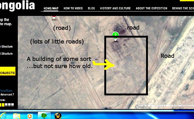
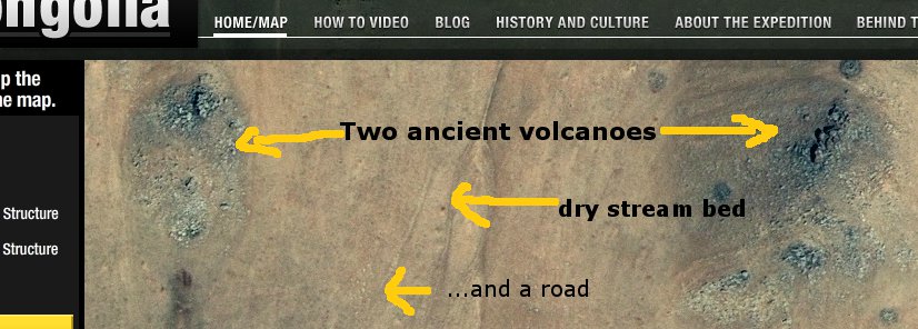
For instance, here's part of an ancient volcano field.
Now, this picture shows some sort of human-made structure. From the air, and from this distance, we can't tell what it is.
I've seen this shape before, which makes me kind of suspect it's reasonably modern and may be used for herding horses or yaks or some other animal. However, without context of time (we don't know how long it's been there) or any other info (they are not giving out coordinates... probably to protect the sites from poachers and thieves) it's hard to say what's there. After taking this picture for your reference, I marked the object "unknown." I tend to be conservative with tags.
edit on 14-6-2013 by Byrd because: (no reason given)
edit on 14-6-2013 by Byrd because: (no reason given)
Originally posted by Byrd
...The lack of scale IS bothersome, as is the lack of ability to zoom.
...
Now, this picture shows some sort of human-made structure. From the air, and from this distance, we can't tell what it is.
I've seen this shape before, which makes me kind of suspect it's reasonably modern and may be used for herding horses or yaks or some other animal. However, without context of time (we don't know how long it's been there) or any other info (they are not giving out coordinates... probably to protect the sites from poachers and thieves) it's hard to say what's there. After taking this picture for your reference, I marked the object "unknown." I tend to be conservative with tags.
Yeah - the inability to zoom is frustrating... I use a 32" monitor (or something like that)...and it isn't helping much.
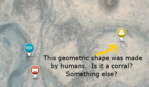
I think you're probably correct about the "corral".
With the limited resources they are making available - I have to wonder at "how much help" they're actually hoping to gain from this "joint-venture". Then again - Google Earth's images of the region are sorely lacking.
new topics
-
Shocking Number of Voters are Open to Committing Election Fraud
US Political Madness: 43 minutes ago -
Gov Kristi Noem Shot and Killed "Less Than Worthless Dog" and a 'Smelly Goat
2024 Elections: 1 hours ago -
Falkville Robot-Man
Aliens and UFOs: 1 hours ago -
James O’Keefe: I have evidence that exposes the CIA, and it’s on camera.
Whistle Blowers and Leaked Documents: 2 hours ago -
Australian PM says the quiet part out loud - "free speech is a threat to democratic dicourse"...?!
New World Order: 3 hours ago -
Ireland VS Globalists
Social Issues and Civil Unrest: 3 hours ago -
Biden "Happy To Debate Trump"
Mainstream News: 4 hours ago -
RAAF airbase in Roswell, New Mexico is on fire
Aliens and UFOs: 4 hours ago -
What is the white pill?
Philosophy and Metaphysics: 5 hours ago -
Blast from the past: ATS Review Podcast, 2006: With All Three Amigos
Member PODcasts: 6 hours ago
top topics
-
A Warning to America: 25 Ways the US is Being Destroyed
New World Order: 14 hours ago, 21 flags -
Blast from the past: ATS Review Podcast, 2006: With All Three Amigos
Member PODcasts: 6 hours ago, 11 flags -
Biden "Happy To Debate Trump"
Mainstream News: 4 hours ago, 8 flags -
Mike Pinder The Moody Blues R.I.P.
Music: 6 hours ago, 7 flags -
James O’Keefe: I have evidence that exposes the CIA, and it’s on camera.
Whistle Blowers and Leaked Documents: 2 hours ago, 5 flags -
Australian PM says the quiet part out loud - "free speech is a threat to democratic dicourse"...?!
New World Order: 3 hours ago, 5 flags -
What is the white pill?
Philosophy and Metaphysics: 5 hours ago, 5 flags -
Ireland VS Globalists
Social Issues and Civil Unrest: 3 hours ago, 4 flags -
RAAF airbase in Roswell, New Mexico is on fire
Aliens and UFOs: 4 hours ago, 4 flags -
Putin, Russia and the Great Architects of the Universe
ATS Skunk Works: 9 hours ago, 3 flags
active topics
-
Candidate TRUMP Now Has Crazy Judge JUAN MERCHAN After Him - The Stormy Daniels Hush-Money Case.
Political Conspiracies • 806 • : Annee -
The functionality of boldening and italics is clunky and no post char limit warning?
ATS Freshman's Forum • 14 • : Encia22 -
MULTIPLE SKYMASTER MESSAGES GOING OUT
World War Three • 99 • : cherokeetroy -
University of Texas Instantly Shuts Down Anti Israel Protests
Education and Media • 298 • : CriticalStinker -
Gov Kristi Noem Shot and Killed "Less Than Worthless Dog" and a 'Smelly Goat
2024 Elections • 25 • : FlyersFan -
Falkville Robot-Man
Aliens and UFOs • 4 • : Kurokage -
Shocking Number of Voters are Open to Committing Election Fraud
US Political Madness • 1 • : YourFaceAgain -
-@TH3WH17ERABB17- -Q- ---TIME TO SHOW THE WORLD--- -Part- --44--
Dissecting Disinformation • 700 • : Thoughtful3 -
Putin, Russia and the Great Architects of the Universe
ATS Skunk Works • 26 • : RussianTroll -
Re-election Tactic - JOE BIDEN Hints He May Put Books in the Homes of Black People.
2024 Elections • 30 • : WeMustCare