It looks like you're using an Ad Blocker.
Please white-list or disable AboveTopSecret.com in your ad-blocking tool.
Thank you.
Some features of ATS will be disabled while you continue to use an ad-blocker.

EQ of M 7.4 South of Fiji Islands!
page: 1share:
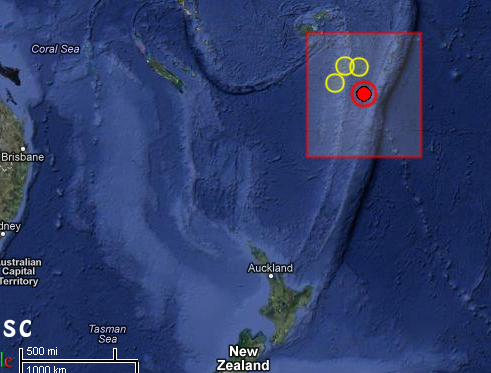
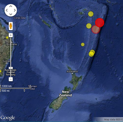
2013-05-23 17:19:02.028min ago 23.10 S 177.02 W 153 7.4 SOUTH OF FIJI ISLANDS
Magnitude Mw 7.4
Region SOUTH OF FIJI ISLANDS
Date time 2013-05-23 17:19:02.0 UTC
Location 23.10 S ; 177.02 W
Depth 153 km
Distances 724 km SE of Suva, Fiji / pop: 77,366 / local time: 05:19:02.0 2013-05-24
281 km SW of Vaini, Tonga / pop: 2,976 / local time: 06:19:02.0 2013-05-24
www.emsc-csem.org...
edit on 23-5-2013 by MariaLida because: (no reason given)
Welp,, Lets hope this isnt the tsunami that iv been hearing about that would hit north east australia.
Originally posted by Exoh92
Welp,, Lets hope this isnt the tsunami that iv been hearing about that would hit north east australia.
EQ was not shallow one so probably noting about tsunami ..
Depth around 180 km ..
Also stronger activity was predicted ..
Originally posted by MariaLida
There was two solar flare and CME's, but last one is really strong one ..
Also probably we will have some stronger seizmic activity in next 72 hrs ..
Two solar flare of M class today from big sunspot 1745
www.abovetopsecret.com...
Originally posted by MariaLida
Still very unstable there, probably more will come ..
2013-05-22 20:08:30.0 16min ago 52.57 N 159.55 E 20 5.0 OFF EAST COAST OF KAMCHATKA
2013-05-22 06:36:37.0 53.03 N 159.90 E 31 5.2 NEAR EAST COAST OF KAMCHATKA
2013-05-21 14:51:19.0 52.57 N 160.65 E 25 5.6 OFF EAST COAST OF KAMCHATKA
www.emsc-csem.org...
Dangerous time for strong EQ in next 48 or 72 hrs for this area also worldwide sensitive areas ..
Solar Flare of M 5.0 and Very Big CMEedit on 22-5-2013 by MariaLida because: (no reason given)
www.abovetopsecret.com...
edit on 23-5-2013 by MariaLida because: (no reason given)
Originally posted by MariaLida
Originally posted by Exoh92
Welp,, Lets hope this isnt the tsunami that iv been hearing about that would hit north east australia.
EQ was not shallow one so probably noting about tsunami ..
Depth around 180 km ..
Energy released has to go somewhere. Hopefully there is enough vertical surfaces slowing the water vibration down before it gets to the shallows. We will see. 7.4 isn't all that small.
edit on 23-5-2013 by marbles87 because: (no reason given)
reply to post by marbles87
That isn't how the dynamics of creating a tsunami work. You have to have land moving and displacing large amounts of water on the ocean floor to get a tsunami. Hope that clears things up for you.
ETA: Basically the sea floor shifts in some way usually up. When the sea floor takes up space occupied by water in a quick motion that means that newly displaced water must go somewhere. The fact that it happens so fast is what causes the power and speed.
edit on 23-5-2013 by RickyD
because: (no reason given)
Originally posted by marbles87
Originally posted by MariaLida
Originally posted by Exoh92
Welp,, Lets hope this isnt the tsunami that iv been hearing about that would hit north east australia.
EQ was not shallow one so probably noting about tsunami ..
Depth around 180 km ..
Energy released has to go somewhere. Hopefully there is enough vertical surfaces slowing the water vibration down before it gets to the shallows. We will see. 7.4 isn't all that small.edit on 23-5-2013 by marbles87 because: (no reason given)
TSUNAMI BULLETIN NUMBER 001
PACIFIC TSUNAMI WARNING CENTER/NOAA/NWS
ISSUED AT 1726Z 23 MAY 2013
THIS BULLETIN APPLIES TO AREAS WITHIN AND BORDERING THE PACIFIC
OCEAN AND ADJACENT SEAS...EXCEPT ALASKA...BRITISH COLUMBIA...
WASHINGTON...OREGON AND CALIFORNIA.
... TSUNAMI INFORMATION BULLETIN ...
THIS BULLETIN IS FOR INFORMATION ONLY.
THIS BULLETIN IS ISSUED AS ADVICE TO GOVERNMENT AGENCIES. ONLY
NATIONAL AND LOCAL GOVERNMENT AGENCIES HAVE THE AUTHORITY TO MAKE
DECISIONS REGARDING THE OFFICIAL STATE OF ALERT IN THEIR AREA AND
ANY ACTIONS TO BE TAKEN IN RESPONSE.
AN EARTHQUAKE HAS OCCURRED WITH THESE PRELIMINARY PARAMETERS
ORIGIN TIME - 1719Z 23 MAY 2013
COORDINATES - 23.1 SOUTH 176.6 WEST
DEPTH - 208 KM
LOCATION - SOUTH OF THE FIJI ISLANDS
MAGNITUDE - 7.4
EVALUATION
A DESTRUCTIVE TSUNAMI WAS NOT GENERATED BASED ON EARTHQUAKE AND
HISTORICAL TSUNAMI DATA.
THIS WILL BE THE ONLY BULLETIN ISSUED FOR THIS EVENT UNLESS
ADDITIONAL INFORMATION BECOMES AVAILABLE.
THE WEST COAST/ALASKA TSUNAMI WARNING CENTER WILL ISSUE PRODUCTS
FOR ALASKA...BRITISH COLUMBIA...WASHINGTON...OREGON...CALIFORNIA.
ptwc.weather.gov...
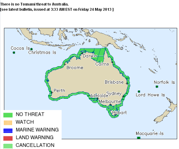
There is no Tsunami threat to Australia.
[see latest bulletin, issued at 3:33 AM EST on Friday 24 May 2013 ]
www.bom.gov.au...[
edit on 23-5-2013 by MariaLida because: (no reason given)
Originally posted by RickyD
reply to post by marbles87
That isn't how the dynamics of creating a tsunami work. You have to have land moving and displacing large amounts of water on the ocean floor to get a tsunami. Hope that clears things up for you.
How can the earth moving not move the water on top of it. So if I take a bucket full of water and then hit the bottom there is no movement on top? The bucket didn't break or split so all the energy went into the water. If it was 180km deep how do we know that a 1km gap didn't jus open somewhere on the sea floor. what absorbed this energy except for the water. I'm more Into electronics than physics so please feel free to explain how there is no way a tsunami can't form.
That's good that there is no cause for alarm with this one glad we have all the tech out there watching this stuff.
edit on 23-5-2013 by
marbles87 because: (no reason given)
reply to post by marbles87
More than likely there wasn't any displacement of land mass.
Usually a land slide is what causes the tsunami.
More than likely there wasn't any displacement of land mass.
Usually a land slide is what causes the tsunami.
reply to post by grey580
In order for a earthquake to be an earthquake something must move. If something moves it is displaced. Just because there wasn't a land slide or sognificant noticeable movement of land ie landslide the land could have moved millimeters in one direction then back in milliseconds or so (earthquake) but movement occurred none the less. Your video stated either just an earthquake or land slide will cause tsunami. I think it's just like 100% bad all over if there is a land slide.
In order for a earthquake to be an earthquake something must move. If something moves it is displaced. Just because there wasn't a land slide or sognificant noticeable movement of land ie landslide the land could have moved millimeters in one direction then back in milliseconds or so (earthquake) but movement occurred none the less. Your video stated either just an earthquake or land slide will cause tsunami. I think it's just like 100% bad all over if there is a land slide.
Geoscience Australia report M 7.5 ..
South of Fiji Islands.
Magnitude: 7.5 (Mwp)
Depth: 100 km
Tsunamigenic: Notified
Visit Tsunami Warning Centre Website
Date and Time
UTC: 23 May 2013 @ 17:18:57
Sydney Time: 24 May 2013 @ 03:18:57 (AEST)
Location
Coordinates: -23.015, -176.909
Solution status
Last updated: 24 May 2013 @ 03:40:05 (AEST)
Solution finalised: No
Source: AUST
www.ga.gov.au...
Originally posted by marbles87
reply to post by grey580
In order for a earthquake to be an earthquake something must move. If something moves it is displaced. Just because there wasn't a land slide or sognificant noticeable movement of land ie landslide the land could have moved millimeters in one direction then back in milliseconds or so (earthquake) but movement occurred none the less. Your video stated either just an earthquake or land slide will cause tsunami. I think it's just like 100% bad all over if there is a land slide.
There a couple of scenarios that explain the absence of a tsunami when the earthquake is so deep.
The 1st version is that this fault ripped in a horizontal fashion; similar to 2 pieces of paper lying flat on a table, and one slides over the over.
This is the technical page from USGS for this EQ. The "beachball" shows one possible interpretation of this quake's motion is in a nearly horizontal plane (8 degrees of dip).
Now remember this happened 180 km down in the soft, gooey mantle. It is very possible that none of this motion transferred to the sea floor surface.
Version 2, is that this just wasn't big enough to generate an observable tsunami. Mag 7.4 is big, but not huge.
The third scenario, is this: think about are the incredible pressures and temperatures the rock is subjected to at that depth.
Sometimes earthquakes represent a metamorphic change in the rock. A big area/chunk of rock reaches a critical tipping point, and the molecules suddenly rearrange themselves. This can change the volume (the physical space) the material occupies, causing the earthquake. It could have shrunk in volume, leaving a void 180 km deep, that again, would not transfer motion to the surface because of the "mushiness" of mantle rock.
I hope this was somewhat helpful.
Cheers
edit on 5/23/2013 by Olivine because: (no reason given)
edit on 5/23/2013 by Olivine because: (no reason given)
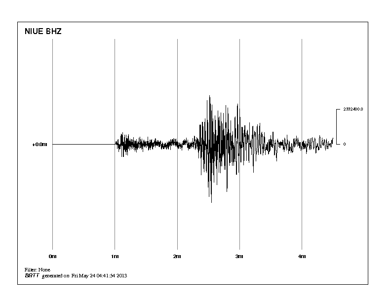
One more stronger one some 220 miles NE from M 7.4 ..
2013-05-23 21:07:46.0 10min ago 20.70 S 175.30 W 144 6.5 TONGA
www.emsc-csem.org...
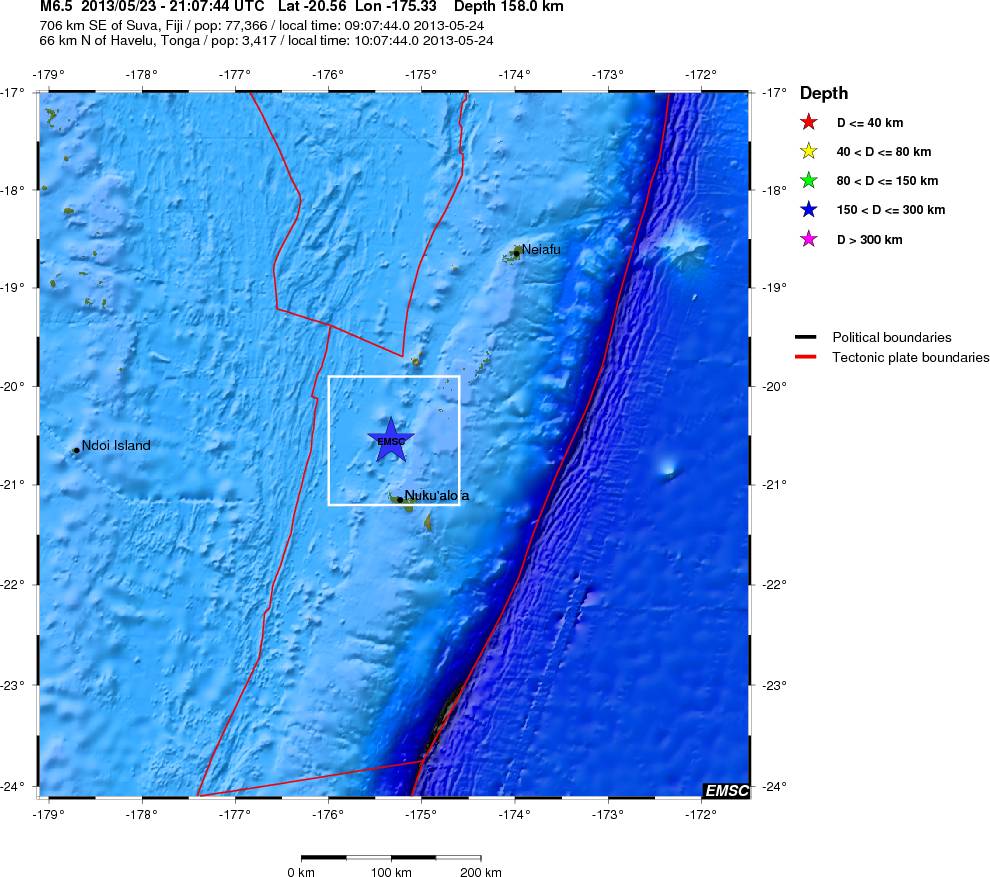
2013-05-23 21:07:46.0 10min ago 20.70 S 175.30 W 144 6.5 TONGA
www.emsc-csem.org...
edit on 23-5-2013 by MariaLida because: (no reason given)
USGS say M 6.6 ..
6.6 84km NW of Nuku`alofa, Tonga 2013-05-23 23:07:40+02:00 103.2 km deep
earthquake.usgs.gov...
We will see is this two strong EQ's make any influences on seizmic situation in New Zealand, hope not
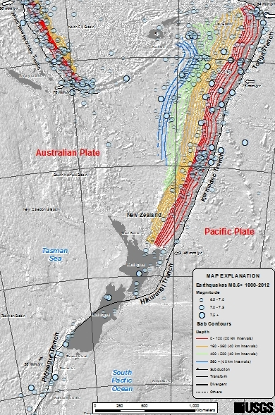
Seismotectonics of the Eastern Margin of the Australia Plate
earthquake.usgs.gov...
6.6 84km NW of Nuku`alofa, Tonga 2013-05-23 23:07:40+02:00 103.2 km deep
earthquake.usgs.gov...
We will see is this two strong EQ's make any influences on seizmic situation in New Zealand, hope not
Seismotectonics of the Eastern Margin of the Australia Plate
earthquake.usgs.gov...
edit on 23-5-2013 by MariaLida because: (no reason given)
from this thread Possible Developments for next So-Cal Big One... this
post you made on 5/15
Great prediction, good job using the data and making a valid, fact-based prediction!! Pretty impressive
I am greatly appreciative for all the time and knowledge you guys put into learning this and SHARING it! Thank you, Thank you!
Originally posted by MariaLida
Sunspot 1748 don't looking good, still beta-gamma-delta configuration ..
www.abovetopsecret.com...
We have one more X-class solar flare, so that's 4 for now ..
Will be very interesting to see is this complex group produce more very strong flares, but I think yes 1748 will be earth direction in some 3-4 days ..
Areas of "West Coast" and SoCal will probably have stronger seizmic activity in next days to days 1748 leave our view, also i try to find free time to monitoring but little possibility for that so precisely EQ prediction not possible
Also dangerous areas: Japan to China to Turkey to Italy, Indonesia to Tonga and west coast of S-C America ..
Think west Peru (maybe Chile also) will probably have very stronger EQ, guess in next 45 days EQ of M 7.5 + ..
Great prediction, good job using the data and making a valid, fact-based prediction!! Pretty impressive
I am greatly appreciative for all the time and knowledge you guys put into learning this and SHARING it! Thank you, Thank you!
reply to post by MariaLida
Large quake hits Tonga
06:52 24/05/2013
www.stuff.co.nz...
Large quake hits Tonga
06:52 24/05/2013
The 7.4-magnitude quake struck 285km southwest of Tonga's capital Nuku'alofa at 5.19am, the US Geological Survey reported.
In New Zealand, GeoNet reported three quakes in the North Island, the largest being 6.1, however it has since deleted the reports because they were caused by the Tongan quake.
www.stuff.co.nz...
edit on 23-5-2013 by MariaLida because: (no reason given)
new topics
-
A Warning to America: 25 Ways the US is Being Destroyed
New World Order: 2 hours ago -
President BIDEN's FBI Raided Donald Trump's Florida Home for OBAMA-NORTH KOREA Documents.
Political Conspiracies: 8 hours ago -
Maestro Benedetto
Literature: 9 hours ago -
Is AI Better Than the Hollywood Elite?
Movies: 9 hours ago
top topics
-
President BIDEN's FBI Raided Donald Trump's Florida Home for OBAMA-NORTH KOREA Documents.
Political Conspiracies: 8 hours ago, 27 flags -
Weinstein's conviction overturned
Mainstream News: 17 hours ago, 8 flags -
Gaza Terrorists Attack US Humanitarian Pier During Construction
Middle East Issues: 14 hours ago, 8 flags -
Massachusetts Drag Queen Leads Young Kids in Free Palestine Chant
Social Issues and Civil Unrest: 16 hours ago, 7 flags -
Las Vegas UFO Spotting Teen Traumatized by Demon Creature in Backyard
Aliens and UFOs: 13 hours ago, 6 flags -
A Warning to America: 25 Ways the US is Being Destroyed
New World Order: 2 hours ago, 6 flags -
Meadows, Giuliani Among 11 Indicted in Arizona in Latest 2020 Election Subversion Case
Mainstream News: 16 hours ago, 5 flags -
2024 Pigeon Forge Rod Run - On the Strip (Video made for you)
Automotive Discussion: 14 hours ago, 4 flags -
Is AI Better Than the Hollywood Elite?
Movies: 9 hours ago, 3 flags -
The functionality of boldening and italics is clunky and no post char limit warning?
ATS Freshman's Forum: 15 hours ago, 1 flags
active topics
-
President BIDEN's FBI Raided Donald Trump's Florida Home for OBAMA-NORTH KOREA Documents.
Political Conspiracies • 18 • : nugget1 -
Gaza Terrorists Attack US Humanitarian Pier During Construction
Middle East Issues • 33 • : FlyersFan -
Weinstein's conviction overturned
Mainstream News • 24 • : burritocat -
-@TH3WH17ERABB17- -Q- ---TIME TO SHOW THE WORLD--- -Part- --44--
Dissecting Disinformation • 690 • : burritocat -
University of Texas Instantly Shuts Down Anti Israel Protests
Education and Media • 266 • : SchrodingersRat -
New whistleblower Jason Sands speaks on Twitter Spaces last night.
Aliens and UFOs • 66 • : baablacksheep1 -
HORRIBLE !! Russian Soldier Drinking Own Urine To Survive In Battle
World War Three • 50 • : F2d5thCavv2 -
Russia Ukraine Update Thread - part 3
World War Three • 5732 • : F2d5thCavv2 -
The Acronym Game .. Pt.3
General Chit Chat • 7751 • : F2d5thCavv2 -
Salvador Dali's Moustaches
People • 28 • : zosimov