It looks like you're using an Ad Blocker.
Please white-list or disable AboveTopSecret.com in your ad-blocking tool.
Thank you.
Some features of ATS will be disabled while you continue to use an ad-blocker.

It's Back; Strange Sound Phenomena Returns to East Tennessee!
page: 4share:
Originally posted by Doodle19815
reply to post by peepsfromearth
Hmmm....why does this name - Linda Moulton Howe - sound familiar?
Never heard of her until I just googled her and see that she runs the earthfiles website. I had a bunch of links that I posted a couple weeks ago on a similar ATS boom thread that went directly to the local MSM news sites but they are no longer out there. At least not from my quick search. The quotes on the earthfiles site all come from MSN sites. I believe this is from the local rhode island news. www.warwickonline.com...
reply to post by esteay812
Just got off of google, I was serious BTW.
Couldn't place her, and wiki didn't help. After further research, reading good, bad, and just strange about her, I realized she is on Ancient Aliens. I guess that is where I picked her name up.
Since the reports are just reports, I will reserve judgment on that site for now........
(She seems to be an in your face kind of journalist that has made a few enemies.)
Some link the booms to this :en.wikipedia.org...
The New Madrid Fault Zone.
I guess its a pretty major fault line that extends all the way up to the St lawrence seaway.......
I don't buy it though. judging from those seismic graphs I'm going with man made.
The New Madrid Fault Zone.
I guess its a pretty major fault line that extends all the way up to the St lawrence seaway.......
I don't buy it though. judging from those seismic graphs I'm going with man made.
edit on 13-2-2013 by peepsfromearth because: (no reason
given)
reply to post by peepsfromearth
The New Madrid would most definitely cause a serious disaster if it were to pop off. I believe it would effect this region, but I think it would more than likely effect the Memphis region in a more severe way - I could be confusing the fault with another one though.
I would think the most probable source for natural seismic activity would be produced by tectonic shifting within the Greenbrier Fault. There are a couple of smaller faults too - I think... Again, if it isn't the New Madrid that's responsible for any regional seismic activity, it would probably have to be the Greenbrier Fault, which, incidentally, happens to be a very good restaraunt located atop a secluded mountain in Gatlinburg. Maybe someone got some bad salsa and their results are what's repsonsible for any regional seismic activity!
The government knows what is causing it but they aren`t going to tell.
I look at it this way, if they government didnt know what was causing it they would be hell bent on finding out.
if the government doesn`t know what is causing it then how can they be sure that it doesn`t pose a threat to ORNL?
I`m sure the government knows exactly what is causing it.
I look at it this way, if they government didnt know what was causing it they would be hell bent on finding out.
if the government doesn`t know what is causing it then how can they be sure that it doesn`t pose a threat to ORNL?
I`m sure the government knows exactly what is causing it.
Seriously, if this would be the New Madrid Fault, America would have a big big problem.
I think it is caused by low ground water... the caves underneath just start to crack and make a sound and rattling noises. Somebody in another thread gave sources to this theory, but I can't remember where
I think it is caused by low ground water... the caves underneath just start to crack and make a sound and rattling noises. Somebody in another thread gave sources to this theory, but I can't remember where
Originally posted by tnhiker
Originally posted by Ektar
reply to post by tnhiker
Ey! Bloody Hell I never heard about those events not sure what year you are speaking of...
I left TN in 1985...the horse mutilations is sickening...were they in the same
area as the sightings?
Cheers
Ektar
I was in high school at the time so it was, uhm, 90, 91?
I found this as a clip from the news sentiniel which touched on it. animal mutilations
wow, talk about a small world. #46 on that link i was involved in. not the bad part of it, but finding out who did it and delivering a little justice the law couldnt. Man, talk about a flash back. I had not thought of those goings on in a long time.
Just. FYI I have a friend not at all conspiracy minded and he was freaked a couple of nights ago after hearing it in Atlanta he is actually some way
north of ATL
edit on 14-2-2013 by hadriana because: (no reason given)
after searching some news papers and finding more
areas reporting this, here is the map i have so far.
img.abovetopsecret.com...
odd its in a line kind of, im leaning twords fault line looking at the reports
from areas that experienced the booms.
off to see if i can find a fault line that matches up to the reports.
areas reporting this, here is the map i have so far.
img.abovetopsecret.com...
odd its in a line kind of, im leaning twords fault line looking at the reports
from areas that experienced the booms.
off to see if i can find a fault line that matches up to the reports.
reply to post by severdsoul
Well we have two factors in play in the area. The Eastern Tennessee Seismic Zone and the The New York-Alabama Lineament. I'm gathering all the info for posting now.
ETA:
The ETSZ is technically considered a very active EQ zone in the USA. One of the factors that plays into that is The New York-Alabama Lineament, a straight magnetic line that runs between New York and Alabama along the Appalachians.
From Discovery News:
news.discovery.com
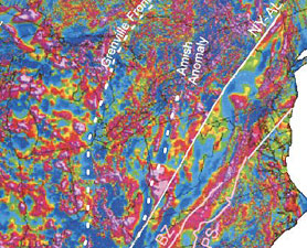
Every since I read about this magnetic fault, I have been fascinated by it and wondered if it had anything to do with the general weirdness that goes on.
------
As for the New Madrid, we would feel it if a big shaker happened there, but since it is over 350 miles away it wouldn't cause the damage like Western TN.
Well we have two factors in play in the area. The Eastern Tennessee Seismic Zone and the The New York-Alabama Lineament. I'm gathering all the info for posting now.
ETA:
The ETSZ is technically considered a very active EQ zone in the USA. One of the factors that plays into that is The New York-Alabama Lineament, a straight magnetic line that runs between New York and Alabama along the Appalachians.
From Discovery News:
For 30 years geologists have been puzzled by a remarkably straight magnetic line that runs between New York and Alabama along the Appalachians.
A more recent aerial magnetic survey of the Alabama end of the line suggests that it's probably a 500-million-year-old San Andreas-style fault that appears to have slipped 137 miles (220 kilometers) to the right in the distant past.
If so, it's no surprise that the most dangerous part of the eastern Tennessee seismic zone is right next to part of this magnetic line and has the second-highest earthquake frequency in the eastern United States.
"It's most likely a strike-slip fault," said Mark Steltenpohl of the University of Alabama at Auburn. "But it's all buried."
news.discovery.com
Every since I read about this magnetic fault, I have been fascinated by it and wondered if it had anything to do with the general weirdness that goes on.
------
As for the New Madrid, we would feel it if a big shaker happened there, but since it is over 350 miles away it wouldn't cause the damage like Western TN.
edit on 14-2-2013 by OneisOne because: add faults and clean it up
reply to post by OneisOne
cool, i'll hold off digging and see what you have.
I find it odd tha they are all in a line of sorts and not a circle patern
of reports.
hmmm i should look up underground water tables/ aquifers as well see if there
is a cave under that area that could tie into this. Who knows whats causing it.
but if we rule enough out, we might find out.
reply to post by severdsoul
Caves? We got more caves then anybody can count!!! And many of them do have something 'watery' going on, underground rivers/lakes.
And we did a tiny lil swam of EQs a few months back along the Appalachia/Blue Ridge Mountains. I'll see if I can dig up my info on it.
And scroll up for the fault info!
Caves? We got more caves then anybody can count!!! And many of them do have something 'watery' going on, underground rivers/lakes.
And we did a tiny lil swam of EQs a few months back along the Appalachia/Blue Ridge Mountains. I'll see if I can dig up my info on it.
And scroll up for the fault info!
edit on 14-2-2013 by OneisOne because: add
Originally posted by Doodle19815
reply to post by peepsfromearth
Hmmm....why does this name - Linda Moulton Howe - sound familiar?
She is the Friday night guest on Coast to Coast AM.
I live in Middle TN and we aren't noticing anything but there are 200 hundred miles between us. I have reason to believe the Fed Gov is building underground all over the country. I have actually been debriefed, by an Israeli Col. in my youth back in the 80's as a member of the US Army, about mole machines just like the ones on the cartoons of that day. People who live in TN know about the cave system that is due to the dissolving limestone rock in geological "Karst" regions. It would be easier to build underground here than most anywhere else with pre-existing chambers to help.
Because of the fragible rock formations it is hard to find a dry cave but I have been in the Civil War salt peter mine called Big Bone up on the Cumberland Plateau. This is a cavern where no water ever travels. So, they do exist. I will star & flag this one for sure! Hope nothing major comes of all this over there!
Originally posted by peepsfromearth
Some link the booms to this :en.wikipedia.org...
The New Madrid Fault Zone.
I guess its a pretty major fault line that extends all the way up to the St lawrence seaway.......
I don't buy it though. judging from those seismic graphs I'm going with man made.edit on 13-2-2013 by peepsfromearth because: (no reason given)
Though it is possible, I think it not likely since that fault line is at least 500 miles away from the Smoky's where the OP is living.
Originally posted by Justoneman
I live in Middle TN and we aren't noticing anything but there are 200 hundred miles between us. I have reason to believe the Fed Gov is building underground all over the country.
That's what I believe too. That's one of my "freak flag flys" conspiracy theories, another being stealth blimps. Which if you add those two things together would explain the booms/shaking and the some of the sky sounds.
On the boom/shaking front, I've had it happen at my house (not too very far from the old K-25 site). I've also heard of weird happenings in the area. Many years ago there localized booms were being heard in the Knoxville area that no one found an explanation for, construction wise. At the same time a co-worker's husband saw a massive oak tree push out of the ground, root ball and all, and fall over on a perfectly calm day.
I've heard all my life about the Smokies having an underground facility and theories on if that could be why so many people go missing there. One of the reasons I entertain the idea is because the Appalachian Mountains are sort of a barrier from the East Coast. With the other side having the TVA power plants and ORNL. Crazy thoughts I know, but I love a good conspiracy!
Originally posted by severdsoul
curious, what is this in the picture? it's not a cloud,
seems a unusual shape.
Google Earth
35°58'16.92"N 83°28'48.81"W
img.abovetopsecret.com...
edit on 13-2-2013 by severdsoul because: (no reason given)

I forgot to reply back to this.
Douglas is not a natural lake, it is one of the ones that was created by TVA. So what you are seeing is the top of a hill that is now underwater. Most people in the area call those 'sand bars' but really all they are is a muddy mess that can damage a boat if you're not careful.
There are many TVA created lakes in the area, and if you are ever bored the histories surrounding them is fascinating.
Morristown Mystery
www.youtube.com...
www.youtube.com...
www.youtube.com...
www.youtube.com... (this video talks about a whole bunch of booms/strange sounds)
My husband and I have heard the strange noise personally.
www.youtube.com...
www.youtube.com...
www.youtube.com...
www.youtube.com... (this video talks about a whole bunch of booms/strange sounds)
My husband and I have heard the strange noise personally.
edit on 14-2-2013 by BlackPhoenix because: videos not showing up on page
But wait this all does tie together a bit, there were warnings in Tennessee last summer about not going into the caves, and they are all supposed to
be closed due to "white nose syndrome." Link: www.digitaljournal.com... Bat sickness???? A reason to keep us away maybe????
Originally posted by thunder57
But wait this all does tie together a bit, there were warnings in Tennessee last summer about not going into the caves, and they are all supposed to be closed due to "white nose syndrome." Link: www.digitaljournal.com... Bat sickness???? A reason to keep us away maybe????
White nose syndrome is a serious issue right up there with colony collapse disorder in bees. Many commercial caves ask visitors not to wear the same clothing/shoes that has been worn while visiting other caves (and with the spred if WNS, that's a good practice to wild caves too). They know for sure that it is transmitted bat to bat, but they also believe that it can be carried on clothing, footwear and gear.
I've spent a lot of time in caves and with cavers and they are furiously protective of those environments. To them finding out WNS is effecting bats in one of their favorite caves is like finding out a family member has cancer.
new topics
-
Biden "Happy To Debate Trump"
Mainstream News: 1 minutes ago -
RAAF airbase in Roswell, New Mexico is on fire
Aliens and UFOs: 10 minutes ago -
What is the white pill?
Philosophy and Metaphysics: 1 hours ago -
Mike Pinder The Moody Blues R.I.P.
Music: 2 hours ago -
Putin, Russia and the Great Architects of the Universe
ATS Skunk Works: 5 hours ago -
A Warning to America: 25 Ways the US is Being Destroyed
New World Order: 9 hours ago
top topics
-
President BIDEN's FBI Raided Donald Trump's Florida Home for OBAMA-NORTH KOREA Documents.
Political Conspiracies: 15 hours ago, 34 flags -
A Warning to America: 25 Ways the US is Being Destroyed
New World Order: 9 hours ago, 18 flags -
Mike Pinder The Moody Blues R.I.P.
Music: 2 hours ago, 6 flags -
Is AI Better Than the Hollywood Elite?
Movies: 17 hours ago, 4 flags -
What is the white pill?
Philosophy and Metaphysics: 1 hours ago, 4 flags -
Putin, Russia and the Great Architects of the Universe
ATS Skunk Works: 5 hours ago, 2 flags -
RAAF airbase in Roswell, New Mexico is on fire
Aliens and UFOs: 10 minutes ago, 2 flags -
Maestro Benedetto
Literature: 17 hours ago, 1 flags -
Biden "Happy To Debate Trump"
Mainstream News: 1 minutes ago, 0 flags
active topics
-
Biden "Happy To Debate Trump"
Mainstream News • 0 • : CarlLaFong -
Gaza Terrorists Attack US Humanitarian Pier During Construction
Middle East Issues • 76 • : KrustyKrab -
New whistleblower Jason Sands speaks on Twitter Spaces last night.
Aliens and UFOs • 71 • : introufo2 -
University of Texas Instantly Shuts Down Anti Israel Protests
Education and Media • 276 • : cherokeetroy -
What is the white pill?
Philosophy and Metaphysics • 10 • : Dalamax -
A Warning to America: 25 Ways the US is Being Destroyed
New World Order • 24 • : charlest2 -
RAAF airbase in Roswell, New Mexico is on fire
Aliens and UFOs • 0 • : pianopraze -
Las Vegas UFO Spotting Teen Traumatized by Demon Creature in Backyard
Aliens and UFOs • 15 • : FlyersFan -
Meadows, Giuliani Among 11 Indicted in Arizona in Latest 2020 Election Subversion Case
Mainstream News • 24 • : Threadbarer -
Democrats Introduce Bill That Will Take Away Donald Trumps Secret Service Protection
2024 Elections • 76 • : Justoneman