It looks like you're using an Ad Blocker.
Please white-list or disable AboveTopSecret.com in your ad-blocking tool.
Thank you.
Some features of ATS will be disabled while you continue to use an ad-blocker.

Quake Watch 2013
page: 26share:
reply to post by SeekingDepth
well actually, the last few days a lot of tension has been released.
129,162 TTNT (tonnes of TNT) in the Santa Cruz Islands
239,036 TTNT in Hokkaido
alone
well actually, the last few days a lot of tension has been released.
129,162 TTNT (tonnes of TNT) in the Santa Cruz Islands
239,036 TTNT in Hokkaido
alone
edit on 2-2-2013 by muzzy because: (no reason given)
Originally posted by MariaLida
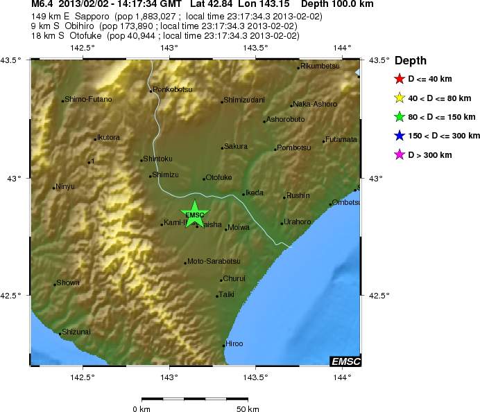
2013-02-02 14:17:34.30 7min ago 42.75 N 143.30 E 93 6.7 HOKKAIDO, JAPAN REGION
Fortunately not shallow one ..
Magnitude M 6.8
Region HOKKAIDO, JAPAN REGION
Date time 2013-02-02 14:17:34.0 UTC
Location 42.84 N ; 143.15 E
Depth 100 km
Distances 149 km E Sapporo (pop 1,883,027 ; local time 23:17:34.3 2013-02-02)
18 km S Otofuke (pop 40,944 ; local time 23:17:34.3 2013-02-02)
9 km S Obihiro (pop 173,890 ; local time 23:17:34.3 2013-02-02)
www.emsc-csem.org...
edit on 2-2-2013 by MariaLida because: (no reason given)
Does anyone know how close to the Fukushima Daichi nuclear plant this quake is. A 6.9 is starting to get big enough to finish off one or more of the buildings there if it struck close and shallow enough. That would raise the level of that disaster by orders of magnitude if it happened.
reply to post by happykat39
approx.600km
I could have told you exactly if I had the co-ordinates of the Plant,
and EMSC are probably wrong with the quake epi-centre as well
as per the link on the previous page
www.jma.go.jp...
Fukushima-ken Nakadori - JMA Intensity 3
Felt by most to all people indoors. Some people are frightened.
Objects inside rattle noticeably and can fall off tables.
Electric wires swing slightly. People can feel it outdoors.
approx.600km
I could have told you exactly if I had the co-ordinates of the Plant,
and EMSC are probably wrong with the quake epi-centre as well
edit on 2-2-2013 by muzzy because: (no reason given)
as per the link on the previous page
www.jma.go.jp...
Fukushima-ken Nakadori - JMA Intensity 3
Felt by most to all people indoors. Some people are frightened.
Objects inside rattle noticeably and can fall off tables.
Electric wires swing slightly. People can feel it outdoors.
edit on 2-2-2013 by muzzy because: (no reason given)
All these six pointers in the Solomons have me thinking 6 is the new 4 LoL they just keep coming has me sitting in Vancouver double checking my B.O.B
and making sure lights and stuff are charged, the earth she's angry it seems
SaneThinking
SaneThinking
Originally posted by SaneThinking
All these six pointers in the Solomons have me thinking 6 is the new 4 LoL they just keep coming has me sitting in Vancouver double checking my B.O.B and making sure lights and stuff are charged, the earth she's angry it seems
SaneThinking
And that would be quite disturbing. However, I am almost totally convinced that this is a not so classic foreshock sequence.
I think there will be an 7.8-8.6, with big waves in the very near future
I will be overjoyed if I am mistaken!!
reply to post by happykat39
Nowhere near (615 km). Hokkaido is the island above the main one.
@Muzzy: Apologies did not see your post
Co-ordinates are: 37.421175 N, 141.020518 E
Nowhere near (615 km). Hokkaido is the island above the main one.
@Muzzy: Apologies did not see your post
Co-ordinates are: 37.421175 N, 141.020518 E
edit on 2/2/2013 by PuterMan because: (no reason given)
reply to post by SaneThinking
Like I said, the Pacific plate is turning. The bend around Santa Cruz is opening, Japan in compression. South America is joining in as the whole thing gets a shove including the Mid Pacific Ridge. Just look at recent locations including Alaska and it all fits.
Like I said, the Pacific plate is turning. The bend around Santa Cruz is opening, Japan in compression. South America is joining in as the whole thing gets a shove including the Mid Pacific Ridge. Just look at recent locations including Alaska and it all fits.
edit on 2/2/2013 by PuterMan because: (no reason given)
reply to post by SaneThinking
Except they are not in the Solomans, they are Santa Cruz and the trench does a big turn right there.
Alaska started it all with the 7.5
ETA: The Solomans may come yet if that part is twisting down against the Australian plate as that tries to push it up and out of the way.
Except they are not in the Solomans, they are Santa Cruz and the trench does a big turn right there.
Alaska started it all with the 7.5
ETA: The Solomans may come yet if that part is twisting down against the Australian plate as that tries to push it up and out of the way.
edit
on 2/2/2013 by PuterMan because: (no reason given)
The Santa Cruz Feb 1 2013, 22:16 UTC event was not a 6.7 but a doublet, the 2nd at 22:18 UTC
6.3/6.3(GFZ) 6.3/6.4(USGS) or 6.4/6.4(GCMT) - all Mw
6.3/6.3(GFZ) 6.3/6.4(USGS) or 6.4/6.4(GCMT) - all Mw
Originally posted by PuterMan
reply to post by SaneThinking
Like I said, the Pacific plate is turning. The bend around Santa Cruz is opening, Japan in compression. South America is joining in as the whole thing gets a shove including the Mid Pacific Ridge. Just look at recent locations including Alaska and it all fits.
edit on 2/2/2013 by PuterMan because: (no reason given)
Would it be sensible to assume we should see an anti-clockwise pattern around the Pacific plate for any larger earthquake groupings over the course of the year?
I'm also wondering about the pressure on that little corner up by Kamchatka up there, that area's put out some high mag doozies in the past. Could the pressure and stresses from that rotation bottleneck up around there until the proverbial cork goes?
reply to post by happykat39
And another question would be "how close was this to Higashadori, Tomari, or the Rokkasho [mox] Reprocessing Plant ?"
And another question would be "how close was this to Higashadori, Tomari, or the Rokkasho [mox] Reprocessing Plant ?"
Originally posted by PuterMan
reply to post by SaneThinking
Except they are not in the Solomans, they are Santa Cruz and the trench does a big turn right there.
I am confused, the Santa Cruz Islands are part of the Solomons... what do you mean by saying they are not in the solomons.... I don't get it. Even USGS has them always listed as Solomons.
reply to post by aLLeKs
Geographically/Politically or Geologically?
Santa Cruz Islands are geologically more a part of Vanuatu IMO. Bismark and Soloman are seismic region 15 and Vanuatu/SantaCruz are seismic region 14.
Where?
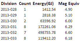
Some data for Santa Cruz BTW. Equivalents of the output of the last 7 days.
Geographically/Politically or Geologically?
Santa Cruz Islands are geologically more a part of Vanuatu IMO. Bismark and Soloman are seismic region 15 and Vanuatu/SantaCruz are seismic region 14.
Even USGS has them always listed as Solomons.
Where?
Some data for Santa Cruz BTW. Equivalents of the output of the last 7 days.
reply to post by aLLeKs
The Santa Cruz islands are politically part of the Solomon Islands, but geographically and geologically they are an extention of Vanuatu (the New Hebrides Is)
Don't you read my posts?I mentioned all that last page.
@ Puterman, touche, you type faster I guess
The Santa Cruz islands are politically part of the Solomon Islands, but geographically and geologically they are an extention of Vanuatu (the New Hebrides Is)
Don't you read my posts?I mentioned all that last page.
@ Puterman, touche, you type faster I guess
edit on 2-2-2013 by muzzy because: (no reason given)
He means the new layout, USGS scrapped the Flinn-Engdahl regions for the new layout.
Only the moment tensors still have the old F-E names.
Now it became XX km ZZZ of [city name here]
The 6.4 22:18 doublet as example earthquake.usgs.gov/earthquakes/eventpage/usc000ezw4
M6.4 - 67km SW of Lata, Solomon Islands 2013-02-01 22:18:35 UTC
Only the moment tensors still have the old F-E names.
Now it became XX km ZZZ of [city name here]
The 6.4 22:18 doublet as example earthquake.usgs.gov/earthquakes/eventpage/usc000ezw4
M6.4 - 67km SW of Lata, Solomon Islands 2013-02-01 22:18:35 UTC
edit on 2-2-2013 by wujotvowujotvowujotvo because: (no reason given)
reply to post by wujotvowujotvowujotvo
That makes a bit of a difference to this post
so delete the 6.4 and replace with to 6.3's makes that 154,130 TTNT for Santa Cruz Is ,
still falls well short of Hokkaido's single 6.8 and minor aftershocks at 239,036 TTNT though.
BTW: All my Santa Cruz calc's are based on GFZ data.
That makes a bit of a difference to this post
Originally posted by muzzy
reply to post by SeekingDepth
well actually, the last few days a lot of tension has been released.
129,162 TTNT (tonnes of TNT) in the Santa Cruz Islands
239,036 TTNT in Hokkaido
alone
edit on 2-2-2013 by muzzy because: (no reason given)
so delete the 6.4 and replace with to 6.3's makes that 154,130 TTNT for Santa Cruz Is ,
still falls well short of Hokkaido's single 6.8 and minor aftershocks at 239,036 TTNT though.
BTW: All my Santa Cruz calc's are based on GFZ data.
reply to post by wujotvowujotvowujotvo
Ah ha.
Well there's another reason not to bother using USGS
It confuses people
Ah ha.
Well there's another reason not to bother using USGS
It confuses people
reply to post by wujotvowujotvowujotvo
Oh, OK. I almost never look at that one.
The 7 day text file still comes through with the FE Regions.
Oh, OK. I almost never look at that one.
The 7 day text file still comes through with the FE Regions.
reply to post by Aircooled
Last report from Kyodo
------------------
00:52 3 February
Magnitude 6.4 quake hits Japan's Hokkaido, but no serious damage
SAPPORO, Feb. 3, Kyodo
english.kyodonews.jp/news/2013/02/207383.html
Last report from Kyodo
------------------
00:52 3 February
Magnitude 6.4 quake hits Japan's Hokkaido, but no serious damage
SAPPORO, Feb. 3, Kyodo
english.kyodonews.jp/news/2013/02/207383.html
An earthquake with a preliminary magnitude of 6.4 struck Japan's northernmost prefecture of Hokkaido late Saturday, leading to highway closures and causing blackouts in some areas, but there were no reports of serious damage or nuclear power plant irregularities, the weather agency and local official said.
The epicenter of the 11:17 p.m. quake was the central part of the Tokachi region in Hokkaido, at a depth of about 120 kilometers, according to Japan Meteorological Agency.
The U.S. Geological Survey said the quake measured magnitude 6.9.
The quake registered upper 5 on the Japanese seismic intensity scale of 7 in Kushiro Akan Chuo, Nemuro Attoko and Urahoro in the eastern part of Hokkaido, and lower 5 in Obihiro and other parts of the prefecture, according to the agency.
Some injuries have been reported. A woman in Obihiro sustained a cut on her leg with glass believed to have been broken in the wake of the quake, according to local fire department officials.
Hokkaido Electric Power Co. said there have been no abnormalities at its nuclear power plant in the village of Tomari in southwestern Hokkaido.
Tohoku Electric Power Co. said no irregularities have been found at its nuclear power plant in the village of Higashidori, Aomori Prefecture.
Japan Nuclear Fuel Ltd. also said there have been no problems at its nuclear fuel reprocessing facility in the village of Rokkasho, Aomori Prefecture.
Copyright 2013 Kyodo News
new topics
-
Biden Withholding Sensitive US Intelligence on Hamas Leaders From Israel
US Political Madness: 1 hours ago -
Anybody else go to the movie theater a lot? Have you noticed how dead they are?
General Chit Chat: 1 hours ago -
Trump Record Breaking Campaign Rally 5/11 in New Jersey Draws 100,000 People
2024 Elections: 1 hours ago -
something falls in Canada
Aliens and UFOs: 1 hours ago -
US mistakes in assessing the military potential of China and Russia
ATS Skunk Works: 4 hours ago -
Slow moving ufo over Mexico volcano Popocatepetl 8 May 2024
Aliens and UFOs: 11 hours ago
top topics
-
A new Why Files How CRISPR and AI Destroy the World
Science & Technology: 12 hours ago, 8 flags -
Trump Record Breaking Campaign Rally 5/11 in New Jersey Draws 100,000 People
2024 Elections: 1 hours ago, 6 flags -
Ask AI Is A Hot Mess
Links & Other Resources: 12 hours ago, 5 flags -
Slow moving ufo over Mexico volcano Popocatepetl 8 May 2024
Aliens and UFOs: 11 hours ago, 4 flags -
Biden Withholding Sensitive US Intelligence on Hamas Leaders From Israel
US Political Madness: 1 hours ago, 4 flags -
US mistakes in assessing the military potential of China and Russia
ATS Skunk Works: 4 hours ago, 3 flags -
Anybody else go to the movie theater a lot? Have you noticed how dead they are?
General Chit Chat: 1 hours ago, 2 flags -
something falls in Canada
Aliens and UFOs: 1 hours ago, 1 flags
active topics
-
Trump Record Breaking Campaign Rally 5/11 in New Jersey Draws 100,000 People
2024 Elections • 13 • : Irishhaf -
Biden Withholding Sensitive US Intelligence on Hamas Leaders From Israel
US Political Madness • 11 • : Threadbarer -
Bibi’s Dilemma
Middle East Issues • 220 • : KrustyKrab -
Woman In Her 60s Stabbed To Death In London Street By Thief Who Tried To Steal Her Bag.
Social Issues and Civil Unrest • 46 • : VariedcodeSole -
something falls in Canada
Aliens and UFOs • 5 • : DronesandUFOs -
"The Fool" - A short video featuring a harmonica-playing guy blasted by a UFO
Aliens and UFOs • 19 • : Ophiuchus1 -
Anybody else go to the movie theater a lot? Have you noticed how dead they are?
General Chit Chat • 2 • : Bluntone22 -
Go Woke, Go Broke--Forbes Confirms Disney Has Lost Money On Star Wars
Movies • 20 • : YourFaceAgain -
-@TH3WH17ERABB17- -Q- ---TIME TO SHOW THE WORLD--- -Part- --44--
Dissecting Disinformation • 949 • : RookQueen2 -
US mistakes in assessing the military potential of China and Russia
ATS Skunk Works • 9 • : Kurokage