It looks like you're using an Ad Blocker.
Please white-list or disable AboveTopSecret.com in your ad-blocking tool.
Thank you.
Some features of ATS will be disabled while you continue to use an ad-blocker.

Quake Watch 2013
page: 16share:
Wowza!
4.4 56km ESE of Moab, Utah 2013-01-23 23:46:39 38.301°N 108.997°W 2.5
earthquake.usgs.gov...
I'm eager to see how much they dial it up or down.
Edit: Adjusted down:
3.9 56km ESE of Moab, Utah 2013-01-23 23:46:39 38.324°N 108.989°W 2.5
Still a pretty good shake for the area, and shallow at that.
4.4 56km ESE of Moab, Utah 2013-01-23 23:46:39 38.301°N 108.997°W 2.5
earthquake.usgs.gov...
I'm eager to see how much they dial it up or down.
Edit: Adjusted down:
3.9 56km ESE of Moab, Utah 2013-01-23 23:46:39 38.324°N 108.989°W 2.5
Still a pretty good shake for the area, and shallow at that.
edit on 1/23/2013 by Nyiah because: (no reason given)
Originally posted by Nyiah
Wowza!
4.4 56km ESE of Moab, Utah 2013-01-23 23:46:39 38.301°N 108.997°W 2.5
earthquake.usgs.gov...
I'm eager to see how much they dial it up or down.
How unusual. Been waiting for it to be reviewed as well.
The area history section says it's no stranger to seismic activity, but it's still notable:
5.3 16km NE of Belyashi, Russia 2013-01-24 02:35:42 49.825°N 87.604°E 41.8
earthquake.usgs.gov...
Also, albeit nothing special, they stuck out to me for some reason:
3.1 30km ENE of Three Rivers, California 2013-01-24 03:22:26 36.562°N 118.601°W 10.9
4.0 34km SW of Smith Valley, Nevada 2013-01-24 03:21:48 38.557°N 119.632°W 13.1
earthquake.usgs.gov...
reply to post by happykat39
Absolutely, which is why statements of statistics have to be backed by facts, figures and charts. It is not sufficient to make a statistical statement without this backing. This does not mean it has to be right, but the reasoning by which such a statement is derived should be transparent. In fact upon reflection despite the fact that I have given details elsewhere I was not right to state "it is quieter now than it has been" without giving links to where I have said this. I will have to go and find them.
You have now provided your figures, for which I thank you, and which I shall examine and later on comment upon.
I said:
"Please set out precisely where there is an uptick in activity in order to back up that statement, bearing in mind that it is quieter now than it has been even by comparison to last year. Please also show where activity is taking place where it has not done so before. I would be interested to know since I have obviously missed it."
I asked you to back your statement. I see nothing uncivil about that. I would not be offended if you asked exactly the same of me. After all is ATS not famous for "pics or it didn't happen" which is the same thing.
The second part I said:
"I found that to be an extremely sensationalist site that takes absolutely no account of the text of reports or researches into what it is reporting."
This was not an incivility, merely my opinion about that site. It made no reference to your choice of that site, only that I did not find that site to be a useful or reliable source of information.
In fact the RT report has been picked up incorrectly by so many sites now and promulgated as happening right now that I am at a loss to understand how any of these people can make any decisions about anything if they are not capable of doing a bit of research for themselves.
I never take anyone's statement at face value (including yours ) and always look to see if the information can be verified.
By the way seeing eye to eye and agreeing on things is not of any relevance to any scientific discussion, in fact it is just those cosy agreements that have led us up the garden path to the place we are now at where science cannot be trusted, so no, we may not see eye to eye or agree always, but that is good as it keeps us active, thinking and on our mettle.
A 'spade' is not a 'manual soil relocation implement' and I shall never call it such!
Mark Twain said "there are three kinds of lies; lies, damn lies and statistics"
Absolutely, which is why statements of statistics have to be backed by facts, figures and charts. It is not sufficient to make a statistical statement without this backing. This does not mean it has to be right, but the reasoning by which such a statement is derived should be transparent. In fact upon reflection despite the fact that I have given details elsewhere I was not right to state "it is quieter now than it has been" without giving links to where I have said this. I will have to go and find them.
You have now provided your figures, for which I thank you, and which I shall examine and later on comment upon.
Puterman, this is for you. We may not agree or see eye to eye on some things, but you will notice I treated you in a much more civil manner in this reply than you treated me in your reply. We can compare data and learn from each other if we are civil to each other. Can you do that?
I said:
"Please set out precisely where there is an uptick in activity in order to back up that statement, bearing in mind that it is quieter now than it has been even by comparison to last year. Please also show where activity is taking place where it has not done so before. I would be interested to know since I have obviously missed it."
I asked you to back your statement. I see nothing uncivil about that. I would not be offended if you asked exactly the same of me. After all is ATS not famous for "pics or it didn't happen" which is the same thing.
The second part I said:
"I found that to be an extremely sensationalist site that takes absolutely no account of the text of reports or researches into what it is reporting."
This was not an incivility, merely my opinion about that site. It made no reference to your choice of that site, only that I did not find that site to be a useful or reliable source of information.
In fact the RT report has been picked up incorrectly by so many sites now and promulgated as happening right now that I am at a loss to understand how any of these people can make any decisions about anything if they are not capable of doing a bit of research for themselves.
I never take anyone's statement at face value (including yours ) and always look to see if the information can be verified.
By the way seeing eye to eye and agreeing on things is not of any relevance to any scientific discussion, in fact it is just those cosy agreements that have led us up the garden path to the place we are now at where science cannot be trusted, so no, we may not see eye to eye or agree always, but that is good as it keeps us active, thinking and on our mettle.
A 'spade' is not a 'manual soil relocation implement' and I shall never call it such!
reply to post by happykat39
I just spent 4 hours putting together a post - actually three posts worth - and went to copy it and it dumped the whole lot!
To say that I feel like weeping is an understatement. I am extremely upset and even more so annoyed with my own stupidity in not saving the text as I went. I should know better!
I will attempt to put it all together again but somehow I doubt it will come out the same anyway just a pointer as regards E. Tennessee and N. Georgia and all of that lowland area think anthropogenic - all the oil and gas wells in those states are concentrated in those areas.
While I put it back together, here is the Nevada data for the past 4 years.
XLSX file so if you need XLS just let me know.
update to post by PuterMan
OK here we go again!
Nevada first. I have given you the link to the past 4 years of data which I have in my database. I also did some other work on the Nevada area and the XLSX file for that is here.
This was done in 2011 when there was swarm, and there are links on the Nevada Seismological Lab site. As you can also see on that site there were swarms at other times as well. The 2011 one was discussed from this page on QW 2011 onwards.
Of the 2011 events the site says:
Also on that page, from the 2003 Deep Magma Injection sequence Under North Lake Tahoe:
I don't know specifically what the cause for the current sequence is, but Nevada is no stranger to long earthquake sequences and some may be related to the shattering of the ground in the numerous nuclear tests.
I will post this, although it is a shadow of its former self, as I am now short on time.
OK here we go again!
Nevada first. I have given you the link to the past 4 years of data which I have in my database. I also did some other work on the Nevada area and the XLSX file for that is here.
This was done in 2011 when there was swarm, and there are links on the Nevada Seismological Lab site. As you can also see on that site there were swarms at other times as well. The 2011 one was discussed from this page on QW 2011 onwards.
Of the 2011 events the site says:
In all, there have been several hundred events of Magnitude 1 and larger; only a small fraction of the entire sequence has been reviewed There have been 1000's of smaller magnitude events.
Also on that page, from the 2003 Deep Magma Injection sequence Under North Lake Tahoe:
Following the deep sequence, in 2004 and 2005 earthquake activity has continued at 15 - 10 km depth, more typical depths for earthquakes in the Tahoe area, and may represent degasing or fluids from dike injection event triggering earthquakes at mid-crustal depths
I don't know specifically what the cause for the current sequence is, but Nevada is no stranger to long earthquake sequences and some may be related to the shattering of the ground in the numerous nuclear tests.
I will post this, although it is a shadow of its former self, as I am now short on time.
reply to post by happykat39
Forgot to say (just remembered). Yes lies, damned lies and then there is statistics. I love it!
That table is out of date now and no longer maintained I believe. Quite why they would drop such an important data source for so many people I do not know.
Moving on to the NM quakes now. Back soon.
Investigate dropbox. Much better than emailing.
Forgot to say (just remembered). Yes lies, damned lies and then there is statistics. I love it!
That table is out of date now and no longer maintained I believe. Quite why they would drop such an important data source for so many people I do not know.
Moving on to the NM quakes now. Back soon.
If so, I will offer to e-mail both files to anyone who wants them.
Investigate dropbox. Much better than emailing.
edit on 24/1/2013 by PuterMan because: (no reason given)
reply to post by muzzy
Note to self: Read the thread to the end first. It will save you some time. Thanks Muzzy - I was just using my database but that ANSS data is better as it goes back further.
Note to self: Read the thread to the end first. It will save you some time. Thanks Muzzy - I was just using my database but that ANSS data is better as it goes back further.
reply to post by happykat39
It is not only fracking that causes quakes. Other extraction methods can as well, but that aside the whole of the other areas you mentioned are peppered with oil and gas wells and..
Source
My recent interest has been mostly the states, so I haven't been following worldwide hot spots as closely. As far as I know the known fracking areas are in northeast Arkansas, Oklahoma and Texas. The rest are for the most part pure seismic. At least I haven't seen any data to the contrary, especially the clusters on the map I posted and the quakes in the north east states.
It is not only fracking that causes quakes. Other extraction methods can as well, but that aside the whole of the other areas you mentioned are peppered with oil and gas wells and..
Also, the number of permits doesn't tell the whole picture, he said.
The state doesn't count oil and gas permits separately, plus oil and gas often can be produced from the same well. In addition, horizontal drilling methods mean one well can be used to prospect a wider area, reducing the number of wells needed.
Source
reply to post by happykat39
So when you have looked at the Nevada data - bearing in mind that ANSS and USGS do not record the same things necessarily and data on one may not be on the other, can you then say there are no older clusters when that is exactly what Nevada is reporting with the 2011, 2010 and 2008 sequences? As I mentioned about - in their words thousands of earthquakes.
So when you have looked at the Nevada data - bearing in mind that ANSS and USGS do not record the same things necessarily and data on one may not be on the other, can you then say there are no older clusters when that is exactly what Nevada is reporting with the 2011, 2010 and 2008 sequences? As I mentioned about - in their words thousands of earthquakes.
The western states have been upticking in activity for the past few days, eh?
This is a pic California and Nevada showing the San Andreas Fault and the Walker Lane deformation belt.
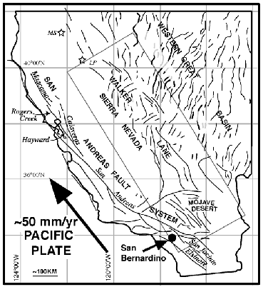
Most of Nevada is part of the basin and range province, where the earths crust is thought to be stretching. But the area from the Mojave desert north to southern Oregon, just east of the Sierra Nevada mountains is the Walker Lane.
The Pacific plate is moving generally to the northwest at about 50 mm/yr. While the North American plate is moving west (for the most part ). It is thought that movement along the San Andreas only accounts for approximately 75% of the movement between these 2 massive plates. Scientists believe the Walker Lane accomodates the missing 25% of the movement.
This 2005 paper by Steve Wesnousky, University of Nevada gives a thorough accounting of the myriad different faults in the fault zone.
"Active faulting in the Walker Lane" (PDF)
Now, I don't know the cause of the current swarmy behavior in western Nevada, but my guess is this:
The Pacific has done some major moving over the past 2 years; in New Zealand, Chile, Japan, and SE Alaska. IMO, all these small quakes in California and Nevada, are signs of the Pacific plate trying to make a move NW. I have no idea whether that will manifest as a big quake on the SAF, Walker Lane, or any number of other faults in the region. Plus, all of this minor unrest can just as quickly die back down to "background" levels, and no big earthquake will come for years.
I just get the feeling the recent activity is all related, and I will not be shocked to see a decent-sized rupture.
This USGS interactive fault map is a useful tool to see if there is a mapped fault associated with earthquakes and swarms we see pop up on the real-time map. If you zoom into western Nevada, you get a sense of the stretching and sliding going on over geologic time.
This is a pic California and Nevada showing the San Andreas Fault and the Walker Lane deformation belt.
Most of Nevada is part of the basin and range province, where the earths crust is thought to be stretching. But the area from the Mojave desert north to southern Oregon, just east of the Sierra Nevada mountains is the Walker Lane.
The Pacific plate is moving generally to the northwest at about 50 mm/yr. While the North American plate is moving west (for the most part ). It is thought that movement along the San Andreas only accounts for approximately 75% of the movement between these 2 massive plates. Scientists believe the Walker Lane accomodates the missing 25% of the movement.
This 2005 paper by Steve Wesnousky, University of Nevada gives a thorough accounting of the myriad different faults in the fault zone.
"Active faulting in the Walker Lane" (PDF)
Now, I don't know the cause of the current swarmy behavior in western Nevada, but my guess is this:
The Pacific has done some major moving over the past 2 years; in New Zealand, Chile, Japan, and SE Alaska. IMO, all these small quakes in California and Nevada, are signs of the Pacific plate trying to make a move NW. I have no idea whether that will manifest as a big quake on the SAF, Walker Lane, or any number of other faults in the region. Plus, all of this minor unrest can just as quickly die back down to "background" levels, and no big earthquake will come for years.
I just get the feeling the recent activity is all related, and I will not be shocked to see a decent-sized rupture.
This USGS interactive fault map is a useful tool to see if there is a mapped fault associated with earthquakes and swarms we see pop up on the real-time map. If you zoom into western Nevada, you get a sense of the stretching and sliding going on over geologic time.
edit on 1/24/2013 by Olivine because: add a link
Hey eq people, never mind, false alarm from the Bayou Corne region. Bad place, and great that people are keeping an eye on it.
Peace
Peace
edit on 24-1-2013 by lasertaglover because: (no reason given)
Originally posted by lasertaglover
Hey eq people, TA has caught something that looks really bad on the seismos for the Bayou Corne sinkhole. Can any of the experts on here take a look.
www.abovetopsecret.com...
Peace
CajunBoy, our boots on the ground in Bayou Corne, has examined the seismo and says it is not quake activity but rather a mechanical disturbance.
read it here
reply to post by happykat39
You are quick, I was just editing my post just now.
Thank goodness it was mechanical.
You are quick, I was just editing my post just now.
Thank goodness it was mechanical.
reply to post by PuterMan
You have given me a lot to consider, and reconsider too, but I am going to have limited time for surfing the web until Saturday. I will respond to what I can as time allows but I won't be able to do a lot today and tomorrow. I am joining a clinical study for a drug similar to what I already use for pain management and will be tied up in all the testing and indoctrination.
You have given me a lot to consider, and reconsider too, but I am going to have limited time for surfing the web until Saturday. I will respond to what I can as time allows but I won't be able to do a lot today and tomorrow. I am joining a clinical study for a drug similar to what I already use for pain management and will be tied up in all the testing and indoctrination.
Activity here in California so far
Thursday January 24 2013, 21:15:21 UTC Baja California, Mexico --- 1.8
Thursday January 24 2013, 21:00:15 UTC Central California --- 2.6
Thursday January 24 2013, 20:40:05 UTC Central California --- 2.8
Thursday January 24 2013, 20:39:41 UTC Greater Los Angeles area, California --- 1.4
Thursday January 24 2013, 20:24:10 UTC Northern California --- 1.6
Thursday January 24 2013, 19:38:39 UTC Southern California --- 1.4
Thursday January 24 2013, 19:37:05 UTC Northern California --- 1.1
Thursday January 24 2013, 19:35:28 UTC Northern California --- 1.0
Thursday January 24 2013, 19:24:25 UTC Central California --- 1.6
Thursday January 24 2013, 19:10:36 UTC Central California --- 1.4
Thursday January 24 2013, 19:10:10 UTC Northern California --- 1.0
Thursday January 24 2013, 18:42:48 UTC off the coast of Oregon --- 2.1
Thursday January 24 2013, 18:36:13 UTC Southern California --- 1.1
Thursday January 24 2013, 18:30:22 UTC Northern California --- 1.1
Thursday January 24 2013, 18:05:50 UTC Greater Los Angeles area, California --- 1.2
Thursday January 24 2013, 17:31:05 UTC Central California --- 1.4
Thursday January 24 2013, 17:07:10 UTC Baja California, Mexico --- 2.3
Thursday January 24 2013, 16:29:35 UTC Central California --- 1.7
Thursday January 24 2013, 16:29:34 UTC Central California --- 1.7
Thursday January 24 2013, 16:27:37 UTC Southern California --- 1.0
Thursday January 24 2013, 16:26:02 UTC Southern California --- 1.2
edit on 7/30/2012 by dreamfox1 because: updates
edit on
7/30/2012 by dreamfox1 because: quakes.globalincidentmap.com...
Still movin' around this Smith Valley area:
4.0 34km SW of Smith Valley, Nevada 2013-01-24 18:25:51 38.560°N 119.619°W 7.7
earthquake.usgs.gov...
That's the biggest thus far. I wonder if that's the max mag it can put out, or if there's a bigger one coming?
4.0 34km SW of Smith Valley, Nevada 2013-01-24 18:25:51 38.560°N 119.619°W 7.7
earthquake.usgs.gov...
That's the biggest thus far. I wonder if that's the max mag it can put out, or if there's a bigger one coming?
Ukraine and Shell sign '$10bn' shale gas deal
Source BBC
Ukraine has signed a major shale gas deal with Royal Dutch Shell - a move seen as an attempt by Kiev to reduce its dependency on Russian gas imports.
BBC Link here www.bbc.co.uk...
Just thought i'd pop this in for future fracking reference if ever needed.
WAYS
Magnitude 3.0
Date-Time
Friday, January 25, 2013 at 00:41:11 UTC
Thursday, January 24, 2013 at 04:41:11 PM at epicenter
Time of Earthquake in other Time Zones
Location 44.457°N, 124.668°W
Depth 33.8 km (21.0 miles)
Region OFFSHORE OREGON
Distances
48 km (30 miles) W (274°) from Waldport, OR
48 km (30 miles) WNW (290°) from Yachats, OR
53 km (33 miles) WSW (248°) from Newport, OR
132 km (82 miles) WNW (290°) from Eugene, OR
199 km (124 miles) SW (234°) from Portland, OR
Location Uncertainty horizontal +/- 0.8 km (0.5 miles); depth +/- 1.2 km (0.7 miles)
Parameters Nph= 12, Dmin=53 km, Rmss=0.16 sec, Gp=248°,
M-type=local magnitude (ML), Version=1
Source
Pacific Northwest Seismic Network
Event ID uw60497317
Activity so far today
UTC Time
Friday January 25 2013, 02:08:50 UTC Greater Los Angeles area, California --- 1.7
Friday January 25 2013, 02:08:04 UTC Southern California --- 1.4
Friday January 25 2013, 02:03:25 UTC Northern California --- 1.1
Friday January 25 2013, 01:23:27 UTC Northern California --- 2.2
Friday January 25 2013, 01:20:05 UTC Northern California --- 2.1
Friday January 25 2013, 01:17:44 UTC Northern California --- 1.2
Friday January 25 2013, 01:13:19 UTC Northern California --- 2.1
Friday January 25 2013, 00:41:11 UTC offshore Oregon --- 3.0
Friday January 25 2013, 00:27:07 UTC Northern California --- 1.0
Friday January 25 2013, 00:26:32 UTC Southern California --- 1.6
Friday January 25 2013, 00:22:03 UTC Nevada --- 1.7
Friday January 25 2013, 00:18:54 UTC Nevada --- 2.4
Friday January 25 2013, 00:12:53 UTC Nevada --- 2.3
Friday January 25 2013, 00:11:41 UTC Northern California --- 1.2
Friday January 25 2013, 00:06:25 UTC Northern California --- 1.7
Thursday January 24 2013, 23:38:57 UTC Northern California --- 1.7
Thursday January 24 2013, 23:37:36 UTC Northern California --- 1.5
Thursday January 24 2013, 23:36:11 UTC Nevada --- 1.7
Thursday January 24 2013, 23:33:34 UTC Northern California --- 1.9
Thursday January 24 2013, 23:25:51 UTC Northern California --- (4.0)
Thursday January 24 2013, 23:14:45 UTC Northern California --- 1.1
Thursday January 24 2013, 23:09:10 UTC Southern California --- 2.0
Thursday January 24 2013, 22:37:12 UTC Southern California --- 2.0
Thursday January 24 2013, 22:30:52 UTC Nevada --- 2.5
Thursday January 24 2013, 22:28:55 UTC Northern California --- 1.0
Thursday January 24 2013, 22:22:41 UTC Nevada --- 1.5
Thursday January 24 2013, 22:13:27 UTC Greater Los Angeles area, California --- 1.4
Thursday January 24 2013, 21:31:16 UTC Northern California ---1.1
Thursday January 24 2013, 21:15:34 UTC Nevada --- 1.3
Thursday January 24 2013, 21:15:23 UTC Baja California, Mexico --- 1.5
Thursday January 24 2013, 21:15:21 UTC Baja California, Mexico --- 1.8
Thursday January 24 2013, 21:00:15 UTC Central California --- 2.6
Thursday January 24 2013, 20:40:05 UTC Central California --- 2.8
Thursday January 24 2013, 20:39:41 UTC Greater Los Angeles area, California --- 1.4
edit on 7/30/2012 by dreamfox1 because: ()
new topics
-
Is Taco Bell Satanic?
Education and Media: 2 hours ago -
Scientists Find 7 potential Dyson spheres after Scanning 5 million Objects
Space Exploration: 3 hours ago -
Need help understanding the evolution of WHO as a power structure. Shades of the NWO...?
New World Order: 5 hours ago -
The geography of Eden
Religion, Faith, And Theology: 5 hours ago -
US 'Uniparty' officially throws Christians to the lions...
Conspiracies in Religions: 6 hours ago -
REAL ID now a reality
General Conspiracies: 8 hours ago -
'I couldn't cope with Britain anymore': Kurdish man pays smuggler to return him to France
Social Issues and Civil Unrest: 11 hours ago
top topics
-
Oh, Have I got a Goody for You Guys!!!
General Conspiracies: 15 hours ago, 20 flags -
Former Hamas member goes OFF on ‘low grade’ lefty journalist
US Political Madness: 14 hours ago, 14 flags -
Woman In Her 60s Stabbed To Death In London Street By Thief Who Tried To Steal Her Bag.
Social Issues and Civil Unrest: 17 hours ago, 8 flags -
REAL ID now a reality
General Conspiracies: 8 hours ago, 7 flags -
'I couldn't cope with Britain anymore': Kurdish man pays smuggler to return him to France
Social Issues and Civil Unrest: 11 hours ago, 4 flags -
Scientists Find 7 potential Dyson spheres after Scanning 5 million Objects
Space Exploration: 3 hours ago, 4 flags -
US 'Uniparty' officially throws Christians to the lions...
Conspiracies in Religions: 6 hours ago, 3 flags -
An Apple a Day
General Chit Chat: 14 hours ago, 2 flags -
The geography of Eden
Religion, Faith, And Theology: 5 hours ago, 1 flags -
Need help understanding the evolution of WHO as a power structure. Shades of the NWO...?
New World Order: 5 hours ago, 1 flags
active topics
-
REAL ID now a reality
General Conspiracies • 24 • : TheMichiganSwampBuck -
Scientists Find 7 potential Dyson spheres after Scanning 5 million Objects
Space Exploration • 18 • : BeyondKnowledge3 -
Time Traveler Caught on Camera?
Paranormal Studies • 40 • : AliceTheSmall -
Is Taco Bell Satanic?
Education and Media • 9 • : Caver78 -
Mood Music Part VI
Music • 3168 • : lilzazz -
Multipal Solar Storms Coming Our Way This Weekend
Fragile Earth • 24 • : NorthOS -
-@TH3WH17ERABB17- -Q- ---TIME TO SHOW THE WORLD--- -Part- --44--
Dissecting Disinformation • 937 • : daskakik -
Candidate TRUMP Now Has Crazy Judge JUAN MERCHAN After Him - The Stormy Daniels Hush-Money Case.
Political Conspiracies • 1479 • : matafuchs -
Oh, Have I got a Goody for You Guys!!!
General Conspiracies • 55 • : boatguy12 -
Kirkpatrick vs Fugal - Skinwalker ranch briefing.
Aliens and UFOs • 29 • : network dude