It looks like you're using an Ad Blocker.
Please white-list or disable AboveTopSecret.com in your ad-blocking tool.
Thank you.
Some features of ATS will be disabled while you continue to use an ad-blocker.

Quake Watch 2013
page: 18share:
earthquake.usgs.gov/earthquakes/eventpage/usc000ev85#historical-seismicity_1990
neic.usgs.gov/cgi-bin/epic/epic.cgi?SEARCHMETHOD=2&FILEFORMAT=4&SEARCHRANGE=HH&SLAT2=33&SLAT1=31&SLON1=-96&SLON2=-94&SYEAR=1990&SMONTH=1&SDAY=1&E YEAR=2013&EMONTH=12&EDAY=31&LMAG=&UMAG=&NDEP1=&NDEP2=&IO1=&IO2=&CLAT=0.0&CLON=0.0&CRAD=0.0&SUBMIT=Submit+Search
neic.usgs.gov/cgi-bin/epic/epic.cgi?SEARCHMETHOD=2&FILEFORMAT=4&SEARCHRANGE=HH&SLAT2=33&SLAT1=31&SLON1=-96&SLON2=-94&SYEAR=1990&SMONTH=1&SDAY=1&E YEAR=2013&EMONTH=12&EDAY=31&LMAG=&UMAG=&NDEP1=&NDEP2=&IO1=&IO2=&CLAT=0.0&CLON=0.0&CRAD=0.0&SUBMIT=Submit+Search
www.ldeo.columbia.edu/~ekstrom/Research/SWD/current/RADB_SWD_grd.html
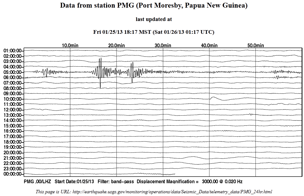
earthquake.usgs.gov/monitoring/operations/data/Seismic_Data/telemetry_data/PMG_24hr.html
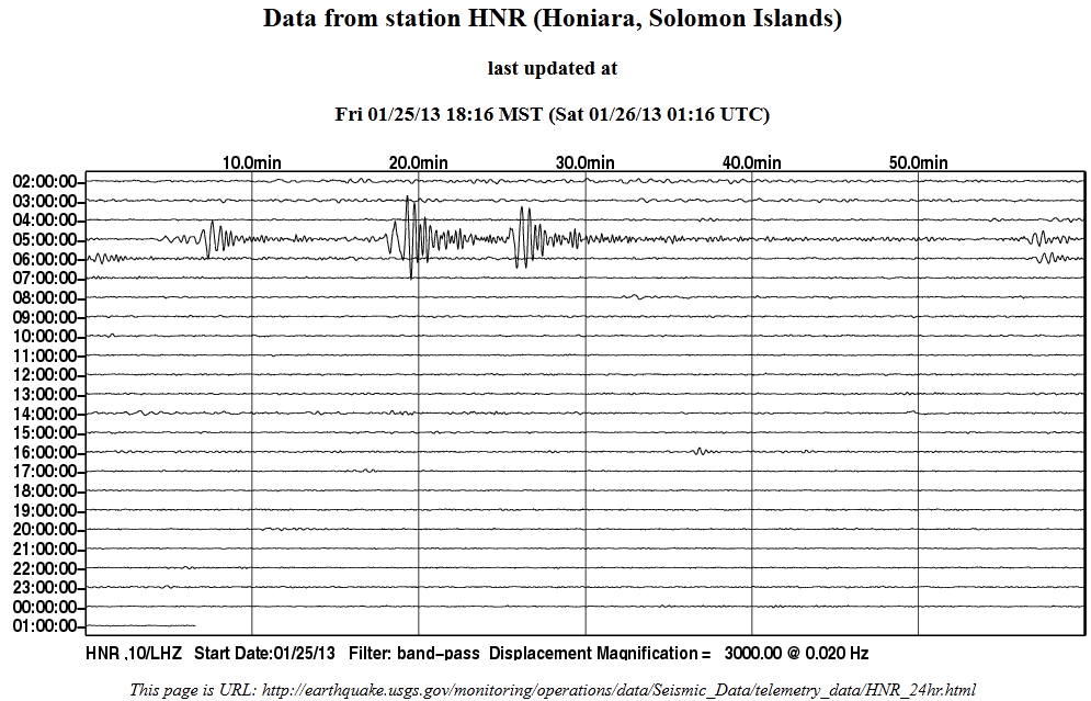
earthquake.usgs.gov/monitoring/operations/data/Seismic_Data/telemetry_data/HNR_24hr.html
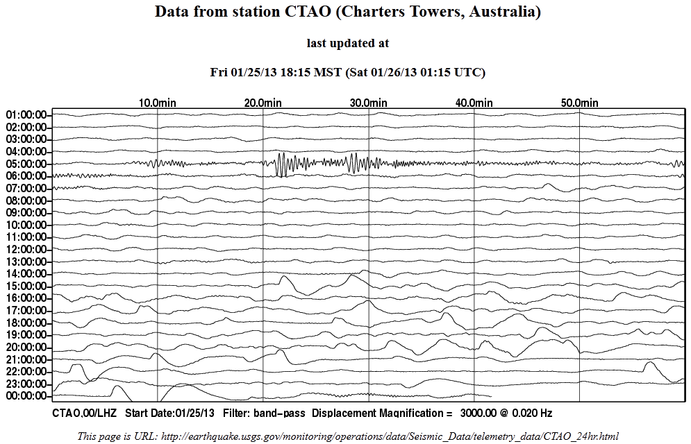
earthquake.usgs.gov/monitoring/operations/data/Seismic_Data/telemetry_data/CTAO_24hr.html
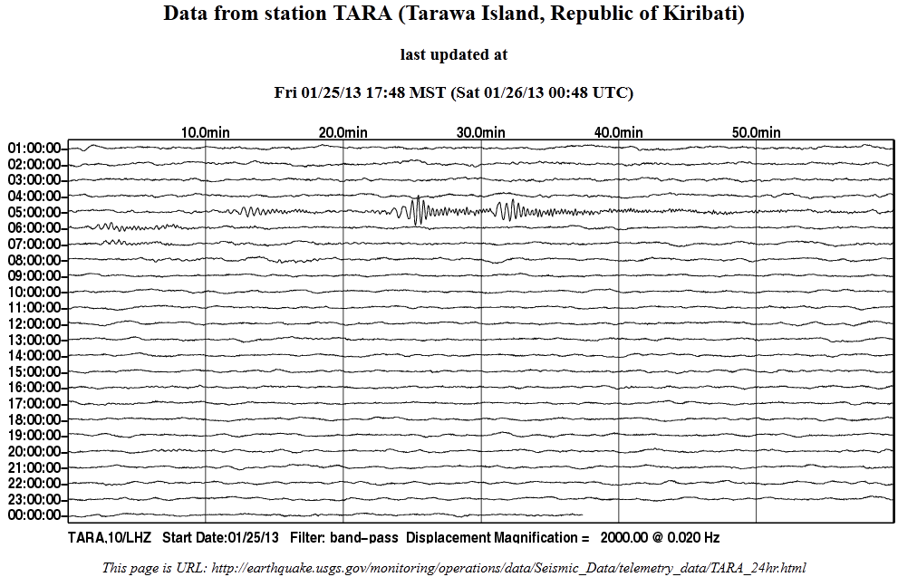
earthquake.usgs.gov/monitoring/operations/data/Seismic_Data/telemetry_data/TARA_24hr.html
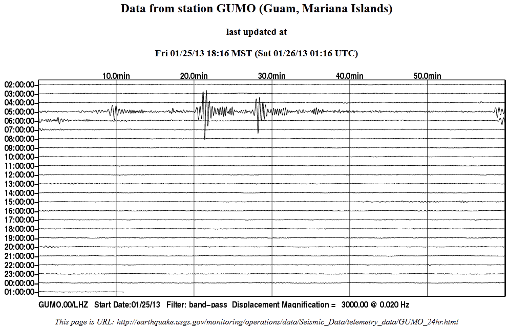
earthquake.usgs.gov/monitoring/operations/data/Seismic_Data/telemetry_data/GUMO_24hr.html
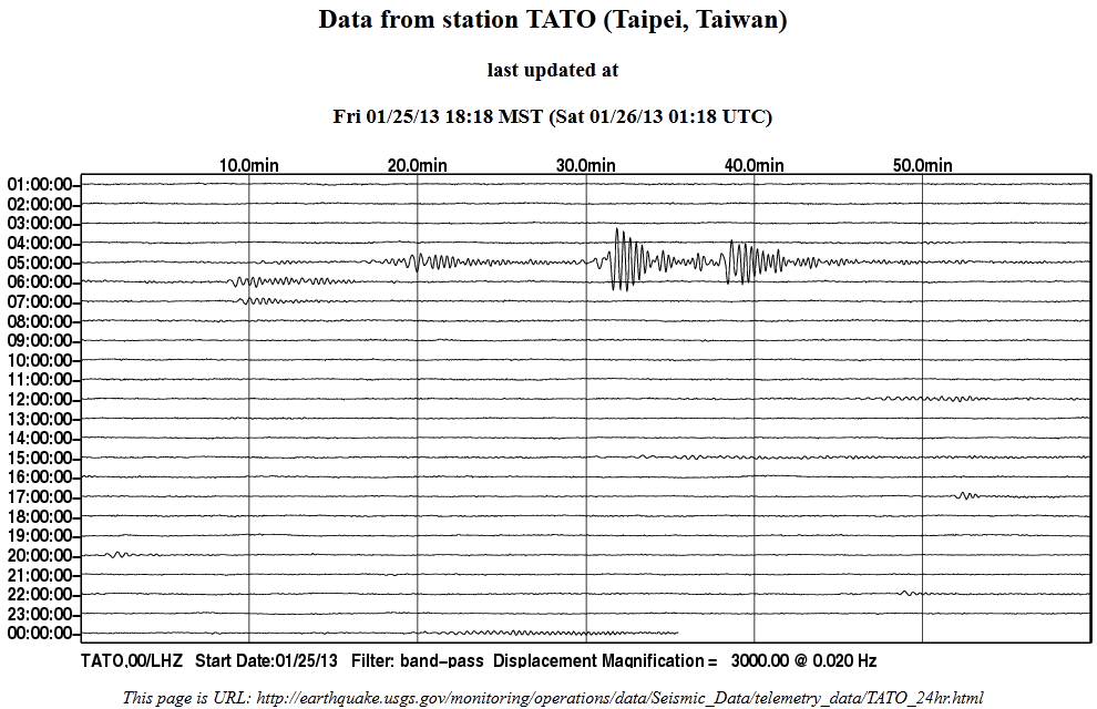
earthquake.usgs.gov/monitoring/operations/data/Seismic_Data/telemetry_data/TATO_24hr.html
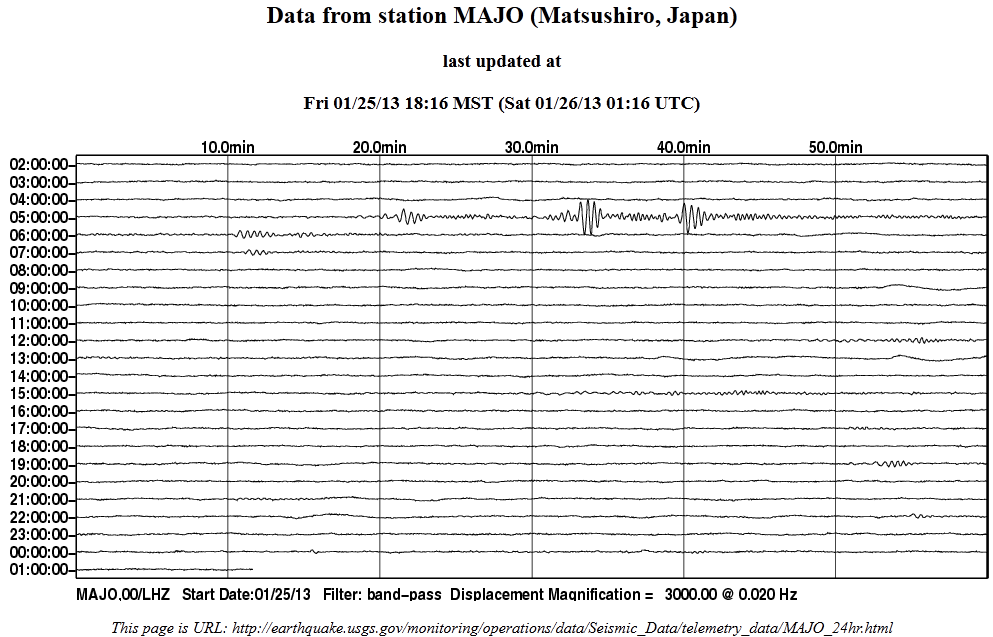
earthquake.usgs.gov/monitoring/operations/data/Seismic_Data/telemetry_data/MAJO_24hr.html
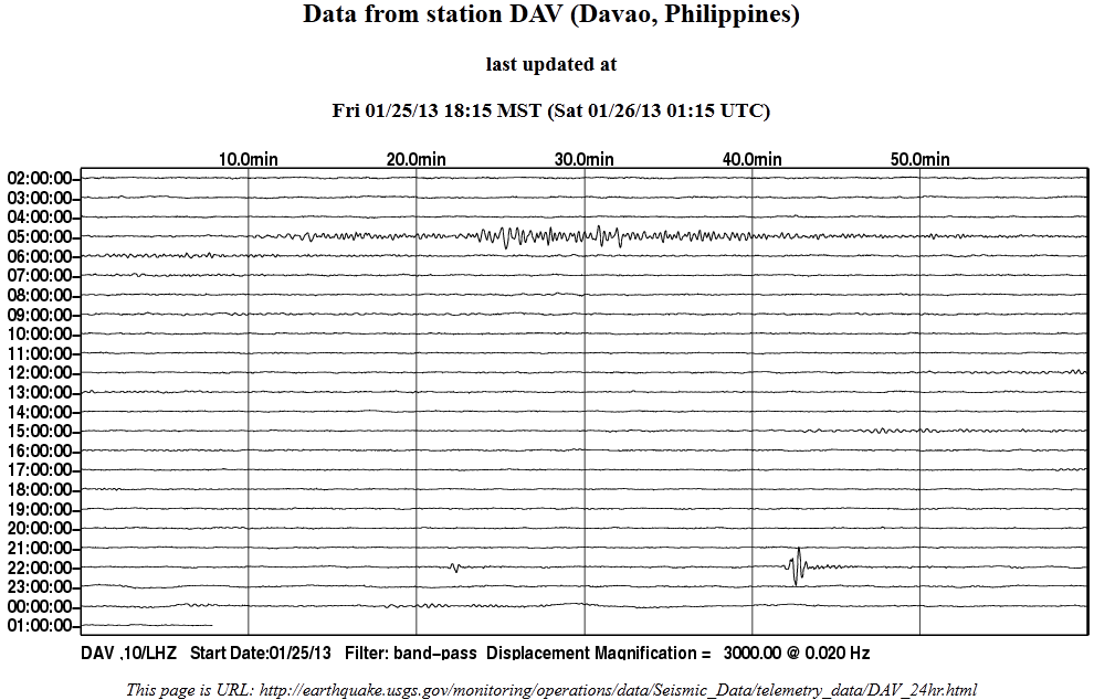
earthquake.usgs.gov/monitoring/operations/data/Seismic_Data/telemetry_data/DAV_24hr.html
earthquake.usgs.gov/monitoring/operations/data/Seismic_Data/telemetry_data/NWAO_24hr.html

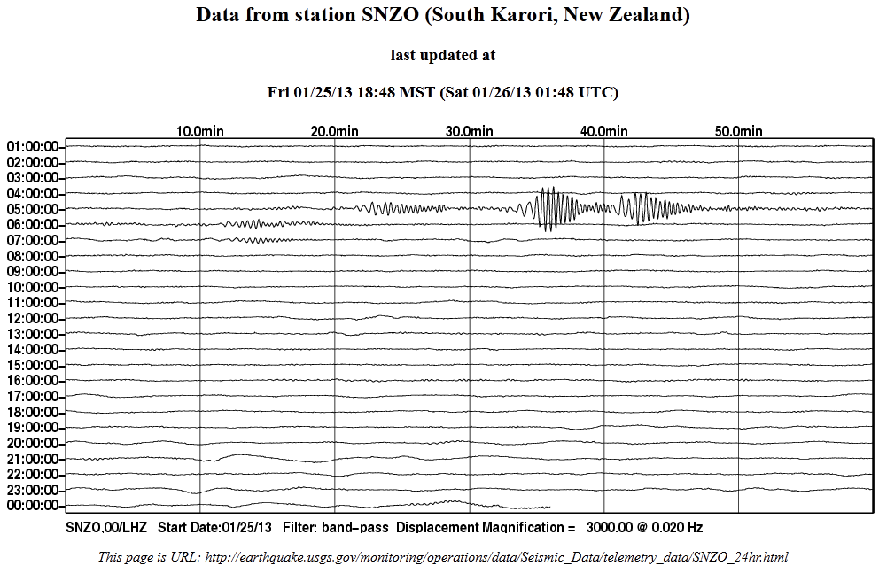
earthquake.usgs.gov/monitoring/operations/data/Seismic_Data/telemetry_data/SNZO_24hr.html
2013 1 25 5 50 16.0 -3.25 149.25 33.0 5.0 BISMARCK SEA
2013 1 25 5 19 28.0 -3.25 149.25 33.0 5.3 BISMARCK SEA
2013 1 25 5 12 40.0 -3.25 149.25 33.0 5.3 BISMARCK SEA
2013 1 25 5 1 4.0 -3.25 149.25 33.0 5.0 BISMARCK SEA
earthquake.usgs.gov/monitoring/operations/data/Seismic_Data/telemetry_data/PMG_24hr.html
earthquake.usgs.gov/monitoring/operations/data/Seismic_Data/telemetry_data/HNR_24hr.html
earthquake.usgs.gov/monitoring/operations/data/Seismic_Data/telemetry_data/CTAO_24hr.html
earthquake.usgs.gov/monitoring/operations/data/Seismic_Data/telemetry_data/TARA_24hr.html
earthquake.usgs.gov/monitoring/operations/data/Seismic_Data/telemetry_data/GUMO_24hr.html
earthquake.usgs.gov/monitoring/operations/data/Seismic_Data/telemetry_data/TATO_24hr.html
earthquake.usgs.gov/monitoring/operations/data/Seismic_Data/telemetry_data/MAJO_24hr.html
earthquake.usgs.gov/monitoring/operations/data/Seismic_Data/telemetry_data/DAV_24hr.html
earthquake.usgs.gov/monitoring/operations/data/Seismic_Data/telemetry_data/NWAO_24hr.html
earthquake.usgs.gov/monitoring/operations/data/Seismic_Data/telemetry_data/SNZO_24hr.html
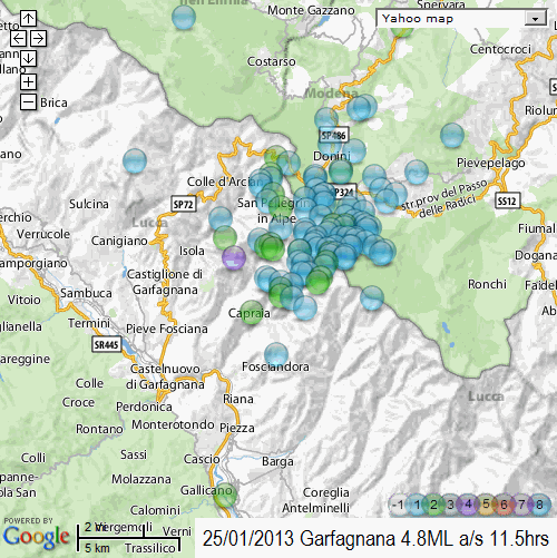
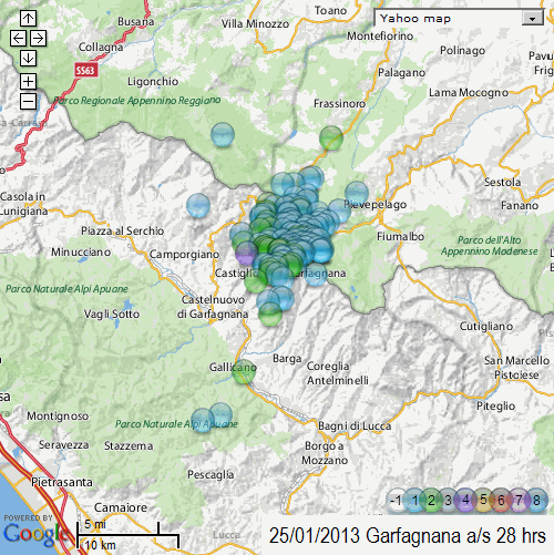
Update on the 25/01/2013 Garfagnana, Italy 4.8ML aftershocks
104 aftershocks in 11.5 hours
[color=lime](click image for interactive map, opens in new tab/window)
I used Yahoo maps for the screenshot this time, those blue highway markers on Google Maps distract from the plots too much
Next update after the 24hour mark
104 aftershocks in 11.5 hours
[color=lime](click image for interactive map, opens in new tab/window)
I used Yahoo maps for the screenshot this time, those blue highway markers on Google Maps distract from the plots too much
Next update after the 24hour mark
edit on 25-1-2013 by muzzy because: (no reason given)
Originally posted by lasertaglover
reply to post by MariaLida
BBC is the only msm source I could find regarding the Italian quake today.
No injuries reported, yay! Power and phone lines are down however.
www.bbc.co.uk...
Peace
Cheers for the link, some interesting background to whats going on with Italy in there.
I might use some of that on the eqarchives Italy pages.
reply to post by muzzy
Emilia Romagna is most active area in Italy, probably we will have more EQ 's here in time ahead ..
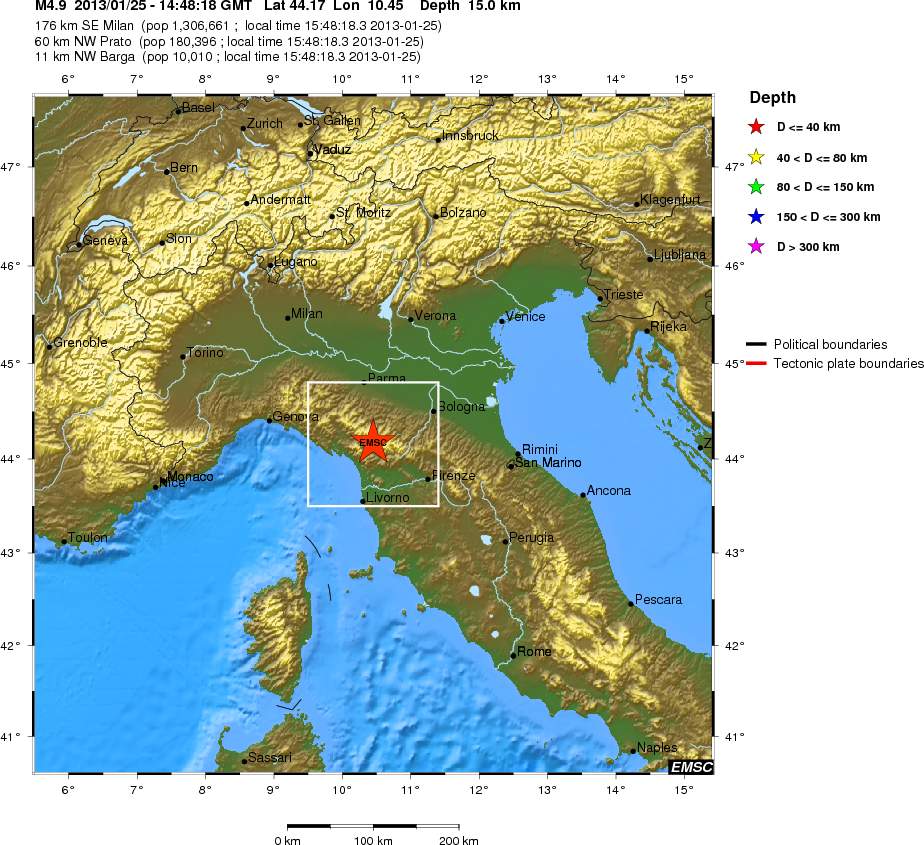
2013-01-25 14:48:18.0 44.17 N 10.45 E 10 5.0 NORTHERN ITALY
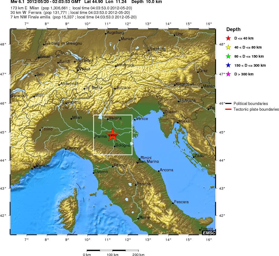
2012-05-29 11:00:24.0 44.91 N 11.02 E 10 5.0 NORTHERN ITALY
2012-05-29 10:55:56.0 44.90 N 10.99 E 2 5.5 NORTHERN ITALY
2012-05-29 07:00:03.0 44.89 N 11.07 E 5 5.8 NORTHERN ITALY
2012-05-20 13:18:03.0 44.83 N 11.44 E 10 5.2 NORTHERN ITALY
2012-05-20 03:02:48.0 44.89 N 11.18 E 2 5.2 NORTHERN ITALY
2012-05-20 02:03:53.0 44.90 N 11.24 E 10 6.1 NORTHERN ITALY
2012-01-27 14:53:14.0 44.48 N 10.03 E 60 5.0 NORTHERN ITALY
Emilia Romagna is most active area in Italy, probably we will have more EQ 's here in time ahead ..
2013-01-25 14:48:18.0 44.17 N 10.45 E 10 5.0 NORTHERN ITALY
2012-05-29 11:00:24.0 44.91 N 11.02 E 10 5.0 NORTHERN ITALY
2012-05-29 10:55:56.0 44.90 N 10.99 E 2 5.5 NORTHERN ITALY
2012-05-29 07:00:03.0 44.89 N 11.07 E 5 5.8 NORTHERN ITALY
2012-05-20 13:18:03.0 44.83 N 11.44 E 10 5.2 NORTHERN ITALY
2012-05-20 03:02:48.0 44.89 N 11.18 E 2 5.2 NORTHERN ITALY
2012-05-20 02:03:53.0 44.90 N 11.24 E 10 6.1 NORTHERN ITALY
2012-01-27 14:53:14.0 44.48 N 10.03 E 60 5.0 NORTHERN ITALY
edit on 26-1-2013 by MariaLida because: (no reason given)
reply to post by MariaLida
Yeah I covered those June 2012 quakes on eqarchives back then
Pianura padana emiliana, Italy 5.9ML 20/05/2012 02:03:52
Pianura padana emiliana, Italy 5.8ML 29/05/2012 07:00:03
Emilia-Romagna, Italy Aftershock Map
I'm not sure they are directly related though
This latest event and aftershocks are on the western side of the Apennines, in Lucca, Tuscany, but some of the aftershocks do cross over into Emilia-Romagna province.
But then provinces are just a line drawn on a map, what I'm interested in is the seismic regions and where they sit.
F_E Regions aren't much good as its just Northern, Central and Southern Italy.
On the INGV main site they give the seismic region for some of the events as
"Distretto sismico: Garfagnana"
the area of the June 2012 events is shown as
"Distretto sismico: Pianura_padana_emiliana"
this map shows Garfagnana quite well
and this map shows Pianura_padana_emiliana
There is probably a map somewhere on INGV that shows all the seiesic regions of Italy but I haven't found it yet.
58 28 new aftershocks since I last looked 12 hours ago, so they are easing off. (104 in the first 11.5hrs)
Actually it was this link that caught my attention on that BBC link,
news.bbc.co.uk...
Yeah I covered those June 2012 quakes on eqarchives back then
Pianura padana emiliana, Italy 5.9ML 20/05/2012 02:03:52
Pianura padana emiliana, Italy 5.8ML 29/05/2012 07:00:03
Emilia-Romagna, Italy Aftershock Map
I'm not sure they are directly related though
This latest event and aftershocks are on the western side of the Apennines, in Lucca, Tuscany, but some of the aftershocks do cross over into Emilia-Romagna province.
But then provinces are just a line drawn on a map, what I'm interested in is the seismic regions and where they sit.
F_E Regions aren't much good as its just Northern, Central and Southern Italy.
On the INGV main site they give the seismic region for some of the events as
"Distretto sismico: Garfagnana"
the area of the June 2012 events is shown as
"Distretto sismico: Pianura_padana_emiliana"
this map shows Garfagnana quite well
and this map shows Pianura_padana_emiliana
There is probably a map somewhere on INGV that shows all the seiesic regions of Italy but I haven't found it yet.
edit on 26-1-2013
by muzzy because: 58 was for the whole of Italy(no reason given)
Actually it was this link that caught my attention on that BBC link,
news.bbc.co.uk...
Set against Africa's march northward at about 2cm a year, Italy is also being pulled and pushed in some complex motions.
The Tyrrhenian Basin, or Sea, which lies to the west of the country, between the mainland and Sardinia/Corsica, is slowly opening up.
Scientists say this is contributing to extension, or "pull-apart", along the Apennines, the belt of mountains that runs down through central Italy.
And to the east, in the Adriatic, there is some evidence that the Earth's crust continues to move under (subducting) Italy, although there is considerable debate about this. Recent GPS data suggests this region, too, is shifting to the northeast.
edit on 26-1-2013 by muzzy
because: (no reason given)
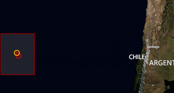
Servicio Sismológico Universidad de Chile has gone and changed the layout of their web site
24th January 2013
blue instead of orange
24th January 2013
blue instead of orange
Garfagnana, Italy Update at 27:50:36 (h:mm:ss) after Main shock
28 new events since 26/01/2013 2:18:56 (131 total)
[color=lime](click image for interactive map, opens in new tab/window)
next update at 72hrs after main shock (if I remember)
28 new events since 26/01/2013 2:18:56 (131 total)
[color=lime](click image for interactive map, opens in new tab/window)
next update at 72hrs after main shock (if I remember)
edit on 26-1-2013 by muzzy because: (no reason given)
Scientists Underestimated Potential for Tohoku Earthquake: Now What?
Jan. 23, 2013
www.sciencedaily.com...
Jan. 23, 2013
www.sciencedaily.com...
In their analysis, the researchers point to several subduction zone areas that previously had been discounted as potential 9.0 earthquake producers -- but may be due for reconsideration. These include central Chile, Peru, New Zealand, the Kuriles fault between Japan and Russia, the western Aleutian Islands, the Philippines, Java, the Antilles Islands and Makran, Pakistan/Iran.
Onshore faults such as the Himalayan Front may also be hiding outsized earthquakes, the researchers add. Their work was supported by the National Science Foundation.
Goldfinger, who directs the Active Tectonics and Seafloor Mapping Laboratory at Oregon State, is a leading expert on the Cascadia Subduction Zone off the Pacific Northwest coast of North America. His comparative studies have taken him to the Indian Ocean, Japan and Chile, and in 2007, he led the first American research ship into Sumatra waters in nearly 30 years to study similarities between the Indian Ocean subduction zone and Cascadia.
Paleoseismic evidence abounds in the Cascadia Subduction Zone, Goldfinger pointed out. When a major offshore earthquake occurs, the disturbance causes mud and sand to begin streaming down the continental margins and into the undersea canyons. Coarse sediments called turbidites run out onto the abyssal plain; these sediments stand out distinctly from the fine particulate matter that accumulates on a regular basis between major tectonic events.
By dating the fine particles through carbon-14 analysis and other methods, Goldfinger and colleagues can estimate with a great deal of accuracy when major earthquakes have occurred. Over the past 10,000 years, there have been 19 earthquakes that extended along most of the Cascadia Subduction Zone margin, stretching from southern Vancouver Island to the Oregon-California border.
"These would typically be of a magnitude from about 8.7 to 9.2 -- really huge earthquakes," Goldfinger said. "We've also determined that there have been 22 additional earthquakes that involved just the southern end of the fault. We are assuming that these are slightly smaller -- more like 8.0 -- but not necessarily. They were still very large earthquakes that if they happened today could have a devastating impact."
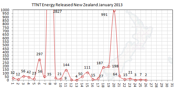
Only been a week since our last mag 5, but the TTNT that been released since is almost down to zero, only 2 tonnes yesterday (26thUTC) , and no mag
3's in the 24hrs at all.
Bit of a worry
Build up of tension
Bit of a worry
Build up of tension
edit on 26-1-2013 by muzzy because: (no reason given)
Originally posted by muzzy
Only been a week since our last mag 5, but the TTNT that been released since is almost down to zero, only 2 tonnes yesterday (26thUTC) , and no mag 3's in the 24hrs at all.
Bit of a worry
Build up of tension
edit on 26-1-2013 by muzzy because: (no reason given)
this seems really a bit odd... hopefully it will regenerate in small mags and not one big one...
reply to post by muzzy
I was just coming to mention that (that it seems like the EQ frequency and mags have nose-dived) You both beat me to it, and reaffirmed what I noticed. I wonder if the swarms in the US might have a correlation? Such as, one side of the plate (Japan) isn't moving as much, but the US side is still going, thus some energy translating/venting on this side? Would it even be able to do that, or am I reaching?
Edit: Never mind! I somehow misread NZ as Japan o.O My observation is void in this case, since it's entirely the wrong location.
edit on
1/26/2013 by Nyiah because: (no reason given)
2013-01-27 09:59:27.01hr 03min ago 16.03 S 173.38 W 10 6.0 TONGA
Magnitude M 6.0
Region TONGA
Date time 2013-01-27 09:59:27.0 UTC
Location 16.03 S ; 173.38 W
Depth 10 km
Distances 3681 km E Brisbane (pop 1,843,392 ; local time 19:59:27.9 2013-01-27)
901 km E Suva (pop 199,455 ; local time 21:59:27.9 2013-01-27)
300 km SW Apia (pop 40,407 ; local time 22:59:27.9 2013-01-26)
41 km E Hihifo (pop 815 ; local time 22:59:27.9 2013-01-27)
www.emsc-csem.org...
reply to post by MariaLida
changed from 6.0M to 5.7Mw, USGS and GFZ the same
The Russians have 6.0mb, but doesn't look like a 6.0 on SNZO
LDEO way off the mark on this one
2013 1 27 9 59 44.0, -15.25, -172.25, 33.0, 5.4Ms, SAMOA ISLANDS REGION
changed from 6.0M to 5.7Mw, USGS and GFZ the same
The Russians have 6.0mb, but doesn't look like a 6.0 on SNZO
LDEO way off the mark on this one
2013 1 27 9 59 44.0, -15.25, -172.25, 33.0, 5.4Ms, SAMOA ISLANDS REGION
reply to post by Nyiah
here is the graph for Japan, reviewed data, not sure if it shows a decline as I have nothing to compare it to (other months)
There are 15 x mag 5's in that.
Japan is a mission on its own, I just processed 2700 lines of data for 18th through 24th January, ended up with 1188 lines (events) after I took out those below mag 1 and those without a magnitude reading.
summary to end of 24th January UTC
2,548 mag1
1,435 mag2
428 mag3
81 mag4
15 mag5
0 mag6
0 mag7
4,507 Total
30,568.1576 TTNT
edit on 27-1-2013 by muzzy because: (no reason given)
reply to post by muzzy
2013-01-27 18:41:49.9 13min ago 36.70 N 140.55 E 77 5.1 NEAR EAST COAST OF HONSHU, JAPAN
Magnitude M 5.1
Region NEAR EAST COAST OF HONSHU, JAPAN
Date time 2013-01-27 18:41:50.0 UTC
Location 36.73 N ; 140.54 E
Depth 80 km
Distances 125 km NE Saitama (pop 1,077,730 ; local time 03:41:50.2 2013-01-28)
19 km NW Hitachi (pop 186,307 ; local time 03:41:50.2 2013-01-28)
15 km W Takahagi (pop 33,576 ; local time 03:41:50.2 2013-01-28)
www.emsc-csem.org...
earthquake.usgs.gov...
static3.emsc.eu...
edit on 27-1-2013 by MariaLida because: (no reason given)
reply to post by MariaLida
Lower 5 intensity registered on Japan's scale at 1 location
JMA - 70 km depth - 4.9 magnitude
www.jma.go.jp/en/quake/20130128034531391-280342.html
Lower 5 intensity registered on Japan's scale at 1 location
JMA - 70 km depth - 4.9 magnitude
www.jma.go.jp/en/quake/20130128034531391-280342.html
Seismic Intensity at each station
(* mark: Local Governments' or NIED's station)
Prefecture JMA Seismic Intensity Station Name
Ibaraki 5- Mito-shi Uchiharacho*
(...)
edit on 27-1-2013 by wujotvowujotvowujotvo because: (no reason given)
reply to post by muzzy
So at least comparing the daily amounts, it has dropped off from the start of the month. Thank you for putting that together Muzzy. It may not have other months to compare with, but it does show a drop in released energy. At least I'm not imagining a decline.
Oh, and I think this is the first one 5.0+ since the 23rd:
5.1 7km NNW of Funaishikawa, Japan 2013-01-27 13:41:48 36.526°N 140.534°E 70.9
earthquake.usgs.gov...
I'm going to go tune in to the NIED ustream, maybe it won't be quite so quiet today?
reply to post by Nyiah
I hope this isn't a calm, before a quake 'storm'!
but it does show a drop in released energy. At least I'm not imagining a decline
I hope this isn't a calm, before a quake 'storm'!
2013-01-27 19:32:43.0 26min ago 34.68 S 108.99 W 10 5.2 SOUTHERN EAST PACIFIC RISE
www.emsc-csem.org...
2013-01-27 13:50:35.0 6hr 08min ago 35.32 S 108.65 W 10 5.1 SOUTHERN EAST PACIFIC RISE
www.emsc-csem.org...
static2.emsc.eu...
www.emsc-csem.org...
2013-01-27 13:50:35.0 6hr 08min ago 35.32 S 108.65 W 10 5.1 SOUTHERN EAST PACIFIC RISE
www.emsc-csem.org...
static2.emsc.eu...
edit on 27-1-2013 by MariaLida because: (no reason given)
new topics
-
University of Texas Instantly Shuts Down Anti Israel Protests
Education and Media: 8 minutes ago -
Any one suspicious of fever promotions events, major investor Goldman Sachs card only.
The Gray Area: 2 hours ago -
God's Righteousness is Greater than Our Wrath
Religion, Faith, And Theology: 6 hours ago -
Electrical tricks for saving money
Education and Media: 9 hours ago -
VP's Secret Service agent brawls with other agents at Andrews
Mainstream News: 11 hours ago -
Sunak spinning the sickness figures
Other Current Events: 11 hours ago
top topics
-
VP's Secret Service agent brawls with other agents at Andrews
Mainstream News: 11 hours ago, 9 flags -
Cats Used as Live Bait to Train Ferocious Pitbulls in Illegal NYC Dogfighting
Social Issues and Civil Unrest: 15 hours ago, 8 flags -
Electrical tricks for saving money
Education and Media: 9 hours ago, 4 flags -
Nearly 70% Of Americans Want Talks To End War In Ukraine
Political Issues: 12 hours ago, 3 flags -
Sunak spinning the sickness figures
Other Current Events: 11 hours ago, 3 flags -
Late Night with the Devil - a really good unusual modern horror film.
Movies: 13 hours ago, 2 flags -
Any one suspicious of fever promotions events, major investor Goldman Sachs card only.
The Gray Area: 2 hours ago, 2 flags -
The Good News According to Jesus - Episode 1
Religion, Faith, And Theology: 17 hours ago, 1 flags -
God's Righteousness is Greater than Our Wrath
Religion, Faith, And Theology: 6 hours ago, 0 flags -
University of Texas Instantly Shuts Down Anti Israel Protests
Education and Media: 8 minutes ago, 0 flags
active topics
-
God's Righteousness is Greater than Our Wrath
Religion, Faith, And Theology • 21 • : andy06shake -
15 Unhealthiest Sodas On The Market
Health & Wellness • 43 • : JPRCrastney -
University of Texas Instantly Shuts Down Anti Israel Protests
Education and Media • 0 • : FlyersFan -
Nearly 70% Of Americans Want Talks To End War In Ukraine
Political Issues • 23 • : andy06shake -
Sunak spinning the sickness figures
Other Current Events • 9 • : Ohanka -
The Acronym Game .. Pt.3
General Chit Chat • 7748 • : bally001 -
HORRIBLE !! Russian Soldier Drinking Own Urine To Survive In Battle
World War Three • 37 • : FlyersFan -
Any one suspicious of fever promotions events, major investor Goldman Sachs card only.
The Gray Area • 3 • : seekshelter -
-@TH3WH17ERABB17- -Q- ---TIME TO SHOW THE WORLD--- -Part- --44--
Dissecting Disinformation • 662 • : F2d5thCavv2 -
SETI chief says US has no evidence for alien technology. 'And we never have'
Aliens and UFOs • 61 • : andy06shake