It looks like you're using an Ad Blocker.
Please white-list or disable AboveTopSecret.com in your ad-blocking tool.
Thank you.
Some features of ATS will be disabled while you continue to use an ad-blocker.

NAZCA's Lost City of the line-builders: Cahuachi
page: 3share:
reply to post by SLAYER69
Awesome thread Slayer. You put some surprises in this one. Not the least of which is that female mummy.
Water erosion? Massive flooding? Well, that got my attention...
Source
Well that's interesting. Just how freak was it?
Yep. The later generations were "standing on the shoulders of giants". Damn kids.
How about a bit of both. The original builders wanted to be buried with their blood, sweat, and tears, and centuries later it became a cemetery?
Awesome thread Slayer. You put some surprises in this one. Not the least of which is that female mummy.
What I find strange is that the prevailing theory is the site was destroyed and possibly abandoned because of a combination of Earthquakes which is common to the area and a massive flood. Now, how one has a massive flood in such a dry location at this altitude is beyond me. The area in question is very dry but bizarrely the remnant ruins show what appears to be water erosion.
Water erosion? Massive flooding? Well, that got my attention...
Source
"A freak climatic disaster to account for the demise of Cahuachi."
Well that's interesting. Just how freak was it?
This is the repeated pattern in many of these ancient cultures. Often finding what appears to be more sophisticated and advanced designs at the lower much older levels.
Yep. The later generations were "standing on the shoulders of giants". Damn kids.
In other words were these mummies from the original builders and was that the locations original purpose?
How about a bit of both. The original builders wanted to be buried with their blood, sweat, and tears, and centuries later it became a cemetery?
reply to post by Klassified
I'm wondering if a few storms could have caused that much erosion?
Also wouldn't they have done repair work between storms?
The time allotted and the type of weather patterns in the region that go back quite a bit doesn't seem to jive with that explanation imho.
In my other thread Tiahuanaco, Puma Punku the real mystery Prof Arthur Posnansky thought that Puma Punku which is on the other side of the mountain range going West thought it also showed signs of a massive flood.
Now, I'm more inclined to think that maybe a large Andean Glacier/ice dam may have let loose a large body of fresh water melt off as apposed to some sort of Biblical flooding etc. Which may have flooded out on both sides of the range East and West.
edit on 14-12-2012 by SLAYER69 because: (no reason given)
reply to post by SLAYER69
That's what makes me question the "freak climatic disaster" theory as being "flash floods". What you're positing makes more sense given the time span.
You would think so, at least early on. Generations down the road, it's hard to say, but if other sites are any indicator of how later generations treated the sites of their ancestors, I would say full repairs were done earlier, and some amount of repair work was at least attempted even if they didn't have the technical know how of the original builders later on.
Agreed. And is there any evidence elsewhere in the area to support their supposition?
Also agreed. Geologists could confirm something like this by examining the whole area for similar evidence of just such an event.
It will be interesting to see what comes of this in the long run.
I'm wondering if a few storms could have caused that much erosion?
That's what makes me question the "freak climatic disaster" theory as being "flash floods". What you're positing makes more sense given the time span.
Also wouldn't they have done repair work between storms?
You would think so, at least early on. Generations down the road, it's hard to say, but if other sites are any indicator of how later generations treated the sites of their ancestors, I would say full repairs were done earlier, and some amount of repair work was at least attempted even if they didn't have the technical know how of the original builders later on.
The time allotted and the type of weather patterns in the region that go back quite a bit doesn't seem to jive with that explanation imho.
Agreed. And is there any evidence elsewhere in the area to support their supposition?
Now, I'm more inclined to think that maybe a large Andean Glacier/ice dam may have let loose a large body of fresh water melt off as apposed to some sort of Biblical flooding etc. Which may have flooded out on both sides of the range East and West.
Also agreed. Geologists could confirm something like this by examining the whole area for similar evidence of just such an event.
It will be interesting to see what comes of this in the long run.
reply to post by SLAYER69
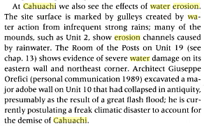
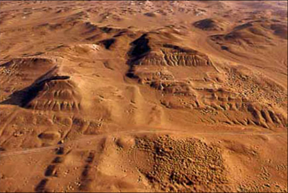
Out of curiosity, I took a look at Cahuachi from Google Earth.
Here's the ruins, located at 14° 49′ 7″ S, 75° 7′ 0″ W:
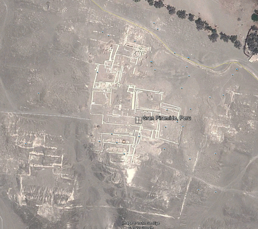
If we go a few miles up and look down, you can see spill ways of dried up river beds, and many dried up river beds:
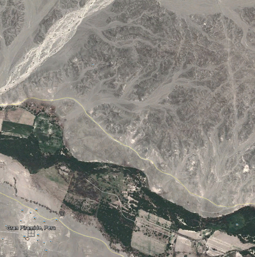
Go up even higher (about 16 miles) and look down, and you can see quite a bit of what looks like water having carved a lot of paths:
Now how long ago these paths were carved by water/ice, I have no idea (I'll let you do the research on it as I'm more at home researching astronomy and astrophysics), but in my humble opinion, the pictures today of the terrain seems to support that the area was a LOT wetter than it is now.
Out of curiosity, I took a look at Cahuachi from Google Earth.
Here's the ruins, located at 14° 49′ 7″ S, 75° 7′ 0″ W:
If we go a few miles up and look down, you can see spill ways of dried up river beds, and many dried up river beds:
Go up even higher (about 16 miles) and look down, and you can see quite a bit of what looks like water having carved a lot of paths:
Now how long ago these paths were carved by water/ice, I have no idea (I'll let you do the research on it as I'm more at home researching astronomy and astrophysics), but in my humble opinion, the pictures today of the terrain seems to support that the area was a LOT wetter than it is now.
reply to post by eriktheawful
I've seen them before. I did a whole google Earth search of the area for like a month a short while back. The whole area and especially on the Western side of the range show extensive run off and dried riverbeds all coming down the range.
I too question when all that occurred and how long ago it all ended. I could imagine a large amount of Snow accumulating during the last Ice age up high and like elsewhere having a fairly continuous yearly run off which the inhabitants could have utilized at the time for irrigation and such until those possible glaciers melted completely away.
Then as that happened and the regional drying started getting closer and closer to the present levels of less and less rainfall occurred those early civilizations/cultures farms and glacier supplied irrigation like the land in the surrounding area dried up and they moved to better more productive areas leaving their cities in the newly dried desert.
edit on 14-12-2012 by SLAYER69 because: (no reason given)
reply to post by SLAYER69
Well during the last ice age that ended 13,000 years ago, the southern hemisphere was not covered as bad as the northern hemisphere.
However, the Andes did have heavy glacial covers during that period that then receded. Hard to find a lot of info as most of the sources on the net want to talk about the northern hemisphere during the last ice age. However, the wikipedia does talk about it, merida glaciation, and here's a PDF file talking about the deglacial period, Andes.
I don't think it was a catastrophic type of melt (ice dams rupturing making massive flooding), and even if it was, there's a problem, in that the site is currently dated 1 CE to 500 CE........of course as pointed out the dating may be faulty due to the site being used off and on by others.
Let us pretend for a minute that there was a culture there that did build it just as the ice age was ending (10k to 13k years ago.......not too far of a stretch for our imaginations since lately it seems we are finding structures dating back over 12k years now), and the deglacion that was happening provided lots of run off and rivers, making the place quite habitable.
As that ice shrinks, the "rivers" start drying up, making people start to abandon places since they no longer have a reliable source for water.
If that happens also when the currents off the coast changed (too much fresh water from the deglacion of the Andes? Or rather changing when the deglacion stops and a lot less fresh water is emptying into the ocean?), so that the climate changes, I could see people abandoning places for lack of water and rain fall to boot.
Hmmmmm.....just an idea anyways. I'm by no means an expert on ancient cultures, climate change, nor ice ages! hehehehehehe. But was just something that piqued my interest.
reply to post by SLAYER69
Slayer in true form. Widening my personal factoid knowledge base without the clutter of any Annunaki gods and golden atmospheres.
SnF
Slayer in true form. Widening my personal factoid knowledge base without the clutter of any Annunaki gods and golden atmospheres.
SnF
reply to post by SLAYER69
This was an absolutely wonderful thread you have put together. I read the entire thing and found it all fascinating.
Thanks.
BAW33
This was an absolutely wonderful thread you have put together. I read the entire thing and found it all fascinating.
Thanks.
BAW33
reply to post by eriktheawful
Thank you for those links and info and you're right it is very hard to find info on how heavily the Andes were covered. This much I know from extensive searches.
Thank you for those links and info and you're right it is very hard to find info on how heavily the Andes were covered. This much I know from extensive searches.
edit on 14-12-2012 by SLAYER69 because: (no reason given)
Great contributions everybody.
I thought many would find this interesting
I thought many would find this interesting
reply to post by SLAYER69
I've been reading a lot about ancient civilizations and quite a few of your older threads studying the links, and i can't help thinking there was a major apocalypse that wiped out a whole advance global civilization across the planet with only a very few survivors, and the species had to start again from scratch.
Now hear me out, this is something that cross my mind after watching a documentary called Lord Of The Ants, by a man called E.O.Wilson who is an American biologist, researcher of sociobiology, biodiversity, theorist, naturalist.
In the documentary at 35 mins in to be exact, he finds a little island teaming with life untouched and out of reach from humans. what he does is cause a mass extinction on this little island killing everything on it, now the interesting part is he comes back 45 years later, and this little island is once again teaming with life to the same level it did 45 years ago, but this time it wasn't the same creatures and bugs, they had been replaced by a different set of bugs and creatures..
Point being in this experiment all life was wiped out on this little island, over time it slowly repopulated with a new species, could this of happen to earth, which would explain the mythical beasts and giants, and the nephilim even the missing link, and the further we go back in time the more amazing and mind boggling the masonry becomes, were in the technology age we live in, we still can't explain how some of it is done.
I'm not that good at explaining myself in text, i have a lot more to say that helps support my theory but it take me all night lol, but i do believe this planet been populated and wiped out many times.
edit on 14-12-2012 by snapperski because: (no reason given)
edit on 14-12-2012 by snapperski because: Spelling
reply to post by SLAYER69
No, not at all, it was a refreshing angle on the whole thing. Bringing together the images that you have along with the way that you relate the lines to the Cahuachi culture really causes the whole thing to snap in to perspective in a way that it would otherwise not. Case in point: this image is so awesome, man...

If I am not mistaken, that is a line, and it shows how close they are in relation to the step pyramids and other structures.
I know you know that I think that these lines were walked in ritual fashion, probably over many days. It's not my own idea, it comes from archeologist, Paul Deveraux. I can imagine that there might have been a whole other contingent of society that inhabited the shaped earthen mounds and step-pyramids, observing while possibly thousands walked the lines, chanting and singing themselves into some kind of altered state of group consciousness.
So, great thread, thanks, I especially enjoyed being able to see that image. It really shows, too, how images can be cherry picked and cropped to shore up very specific narratives, like on the History Channel, and such.
Hopefully not too many will be disappointed in this NAZCA related thread with no images of the lines.
No, not at all, it was a refreshing angle on the whole thing. Bringing together the images that you have along with the way that you relate the lines to the Cahuachi culture really causes the whole thing to snap in to perspective in a way that it would otherwise not. Case in point: this image is so awesome, man...
If I am not mistaken, that is a line, and it shows how close they are in relation to the step pyramids and other structures.
I know you know that I think that these lines were walked in ritual fashion, probably over many days. It's not my own idea, it comes from archeologist, Paul Deveraux. I can imagine that there might have been a whole other contingent of society that inhabited the shaped earthen mounds and step-pyramids, observing while possibly thousands walked the lines, chanting and singing themselves into some kind of altered state of group consciousness.
So, great thread, thanks, I especially enjoyed being able to see that image. It really shows, too, how images can be cherry picked and cropped to shore up very specific narratives, like on the History Channel, and such.
reply to post by snapperski
I appreciate the feedback, insight and perspective.
I'm checking out your provided links now. I have no doubt that as time goes by we will be hearing a lot more about South American discoveries...
I appreciate the feedback, insight and perspective.
I'm checking out your provided links now. I have no doubt that as time goes by we will be hearing a lot more about South American discoveries...
Cahuachi which in Quechua means “from where you look” was an ancient city developed between 400 BC and 450 AD. Cahuachi was a ceremonial center for religious leaders and is believed to be the place where the concept for the Nasca Lines was conceived.
www.ladatco.com...
All those years of hearing that the creators of the lines were very primitive.
Interesting: So much calander watching in the ancient world.
is conclusion: the lines were intended for astronomical observations. His theory inspired a German mathematician, Maria Reiche, who has devoted her life trying to unravel the mystery of the Nazca lines. Like Dr. Kosok, she believed that the lines pointed to prominent stars or to the sun, enabling the Nazca to calculate dates. She contends the animals and other figures may represent star constellations, and so the whole extraordinary web of markings was probably a huge calendar.
www.jcs-group.com...
Originally posted by SLAYER69
What I find strange is that the prevailing theory is the site was destroyed and possibly abandoned because of a combination of Earthquakes which is common to the area and a massive flood. Now, how one has a massive flood in such a dry location at this altitude is beyond me. The area in question is very dry but bizarrely the remnant ruins show what appears to be water erosion
"ancient civilizations wiped off the face of the planet in a devastating pole shift."
these were words ringing in my ear when i came across the surprising reference to a massive flood that destroyed and buried the city of cahuachi. it is a theory put forth by the likes of graham hancock, but his work mainly focused on cities submerged beyond global coast lines. this one about a dramatic pole shift particularly, could well be PERFECT visual aides to one listening to the riveting interviews of brent miller of the horizon project on coast to coast am some years back.
by the way, what comes racing through my mind now is, while we are about six days before the end of the mayan calendar on december 21, 2012, are that these pictures may just be what OUR civilization can be like if brent miller proves to be right with the conclusion of his horizon project that, as our solar system goes through the middle of the galactic plane ANY DAY NOW (called dark rift by the mayans), the super massive waves of energy emanating from the black hole at the center of our milky way can cause the geographic poles of our earth to shift by a few degress but would cause most coast lines on the planet to be inundated and billions to die! (whew!)
i know, but it does not sound as sensational --i can't help it with all the info cramped in one paragraph-- when you listen to the full interviews of brent miller here (it's worth it, i promise. it's all science-driven and none of the metaphysical "consciousness" and the likes stuff):
2006 (or 2007?) coast to coast interview:
november, 2008 coast to coast interview:
(last) january 2009 coast to coast interview:
sorry, if some think the topic is a bit OFF. but when i saw the pics of pyramids buried in sand that i included above, i can't help but think about brent miller out of the blue.
edit on 12/15/2012 by Tulisanes because: all typo corrections
reply to post by SLAYER69
I agree, there seems to be a lot of the missing pieces to the jigsaw of our real history in south america.
If i had the money, i love to do a South American expedition, and actually see these ancients ruins for myself, especially Peru.
I've just finished watching for the 2nd time the documentary you posted in another
thread you created a week or so ago, with David Childress and Christopher Dunn were they study South American ancient masonry work, and it still just blows my mind and leaves me so many questions, i would of loved to been on that journey with them.
I have no doubt that as time goes by we will be hearing a lot more about South American discoveries
I agree, there seems to be a lot of the missing pieces to the jigsaw of our real history in south america.
If i had the money, i love to do a South American expedition, and actually see these ancients ruins for myself, especially Peru.
I've just finished watching for the 2nd time the documentary you posted in another
thread you created a week or so ago, with David Childress and Christopher Dunn were they study South American ancient masonry work, and it still just blows my mind and leaves me so many questions, i would of loved to been on that journey with them.
post by Klassified
I question just how accurately these sites are dated? We seem to have a conflict between two sciences here. On the one hand we have one telling us when the last of the ice melt off occurred then we find temples and other sites from a much more recent period showing signs of massive flooding.
Now which is it?
13,000 B.C. or 3,500 B.C.
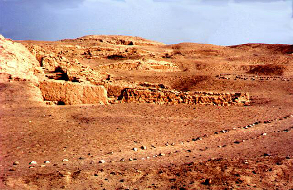
Here is an image that I've always found a bit puzzling. It's a temple complex on the Western side of the range at a site known as Caral Supe which is now recognized as the oldest in Peru and who the builders were Ancient Egypt's contemporaries. Notice how in the image the top left corner shows what appears to be damage from a massive flood slicing off or eroding away a section?
[atsimg]http://files.abovetopsecret.com/images/member/806948a8a0c4.jpg[/atsimg]
It's much more noticeable to those who do a Google Earth view. Those who do look it up will be able to easily follow that swath of flooding destruction back up to the Andes
Which by the way at the same locations and others nearby we also find what appear to be ancient megalithic standing stones from a much earlier period. I wonder if there were a few periods of development from various cultures and as stated earlier those who came later utilized earlier much much older sites...?
[atsimg]http://files.abovetopsecret.com/images/member/bcd3c8d8a156.jpg[/atsimg]
I question just how accurately these sites are dated? We seem to have a conflict between two sciences here. On the one hand we have one telling us when the last of the ice melt off occurred then we find temples and other sites from a much more recent period showing signs of massive flooding.
Now which is it?
13,000 B.C. or 3,500 B.C.
Here is an image that I've always found a bit puzzling. It's a temple complex on the Western side of the range at a site known as Caral Supe which is now recognized as the oldest in Peru and who the builders were Ancient Egypt's contemporaries. Notice how in the image the top left corner shows what appears to be damage from a massive flood slicing off or eroding away a section?
[atsimg]http://files.abovetopsecret.com/images/member/806948a8a0c4.jpg[/atsimg]
It's much more noticeable to those who do a Google Earth view. Those who do look it up will be able to easily follow that swath of flooding destruction back up to the Andes
Which by the way at the same locations and others nearby we also find what appear to be ancient megalithic standing stones from a much earlier period. I wonder if there were a few periods of development from various cultures and as stated earlier those who came later utilized earlier much much older sites...?
[atsimg]http://files.abovetopsecret.com/images/member/bcd3c8d8a156.jpg[/atsimg]
edit on 15-12-2012 by SLAYER69 because: (no reason given)
reply to post by SLAYER69
Funny, I wouldn't have noticed that, had you not pointed it out. A sharp eye. Now it sticks out like a sore thumb.
All things being equal, hasn't this always been part of the problem among academia? We have geologists, archaeologists, engineers, architects, and more studying and theorizing, each from their particular expertise, yet we can't seem to put together all the pieces to form a picture we can examine as a whole. If you'll pardon the analogy, it seems a lot like the old days, when intelligence agencies refused to share and consider info from one another.
That last picture to me, is so telling. To me, we're looking at two different eras. Stonehenge meets Ziggurat.
Just my opinion, and I'm not an expert obviously, but I must agree whole-heartedly. It makes sense that later peoples used these sites, and were, I assume, just as enamored and mystified as we often are. They became sacred sites, and the finders became caretakers, and added their own mysteries over time. And here we are trying to sort out two or sometimes three different cultures, or at the least, periods of time, as if they're one.
Which leads me to another thought about periods of development. I still have this belief that a few civilizations in the far ancient past may very well be responsible for many of the legends and mythology we still cling to today. A few civilizations that were so far ahead of the rest (in comparison), they seemed like gods.
And lastly,
Agreed. I also wonder sometimes just how accurate they CAN be dated, especially considering your own thoughts on the possible history involved. A lot of variables to be considered. But surely not impossible. Somewhere, in all of this, there must be a consensus of data that is often overlooked.
Funny, I wouldn't have noticed that, had you not pointed it out. A sharp eye. Now it sticks out like a sore thumb.
All things being equal, hasn't this always been part of the problem among academia? We have geologists, archaeologists, engineers, architects, and more studying and theorizing, each from their particular expertise, yet we can't seem to put together all the pieces to form a picture we can examine as a whole. If you'll pardon the analogy, it seems a lot like the old days, when intelligence agencies refused to share and consider info from one another.
That last picture to me, is so telling. To me, we're looking at two different eras. Stonehenge meets Ziggurat.
I wonder if there were a few periods of development from various cultures and as stated earlier those who came later utilized earlier much much older sites...?
Just my opinion, and I'm not an expert obviously, but I must agree whole-heartedly. It makes sense that later peoples used these sites, and were, I assume, just as enamored and mystified as we often are. They became sacred sites, and the finders became caretakers, and added their own mysteries over time. And here we are trying to sort out two or sometimes three different cultures, or at the least, periods of time, as if they're one.
Which leads me to another thought about periods of development. I still have this belief that a few civilizations in the far ancient past may very well be responsible for many of the legends and mythology we still cling to today. A few civilizations that were so far ahead of the rest (in comparison), they seemed like gods.
And lastly,
I question just how accurately these sites are dated?
Agreed. I also wonder sometimes just how accurate they CAN be dated, especially considering your own thoughts on the possible history involved. A lot of variables to be considered. But surely not impossible. Somewhere, in all of this, there must be a consensus of data that is often overlooked.
edit on 12/15/2012 by Klassified because: (no reason given)
Just wanted to add, as it seems they where held captive (to die) as prisonors?), since according legend/myth, they (those (remaining?) elongated race
with red/blond hair), where slaughtered by the inca's which could explain their positions in which they have found.
edit on 15-12-2012 by
Plugin because: (no reason given)
reply to post by Klassified
All good points.
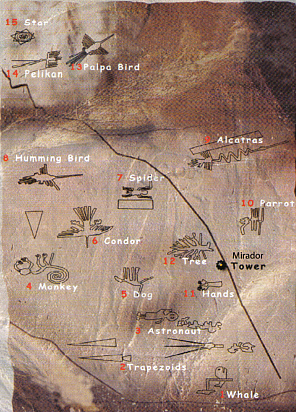
Here is another one puzzling me.
Just how far away did these high desert people trade?
Are Humming birds, Parrots, Monkeys etc etc etc indigenous to their high desert surrounding? Never mind a Whale...
All good points.
Here is another one puzzling me.
Just how far away did these high desert people trade?
Are Humming birds, Parrots, Monkeys etc etc etc indigenous to their high desert surrounding? Never mind a Whale...
edit on 15-12-2012 by SLAYER69 because: (no reason given)
new topics
-
Tschugger
Movies: 23 minutes ago -
Christianity superior to other faiths for very specific reasons. Awaken to true FREEDOM..!!
Conspiracies in Religions: 2 hours ago -
It's all Kicking off at Eurovision 2024
Music: 6 hours ago -
The biggest problem with the Hush money trial
US Political Madness: 7 hours ago -
Armadillos moving north
Fragile Earth: 10 hours ago -
Million dollar idea, and good for your feelz!
Rant: 10 hours ago -
Is there a dependence on the number of children in the family and its well-being?
New World Order: 10 hours ago
top topics
-
Armadillos moving north
Fragile Earth: 10 hours ago, 9 flags -
The biggest problem with the Hush money trial
US Political Madness: 7 hours ago, 7 flags -
Million dollar idea, and good for your feelz!
Rant: 10 hours ago, 5 flags -
Barron Trump has prior commitments?
Politicians & People: 16 hours ago, 4 flags -
Is there a dependence on the number of children in the family and its well-being?
New World Order: 10 hours ago, 3 flags -
It's all Kicking off at Eurovision 2024
Music: 6 hours ago, 3 flags -
Christianity superior to other faiths for very specific reasons. Awaken to true FREEDOM..!!
Conspiracies in Religions: 2 hours ago, 2 flags -
Tschugger
Movies: 23 minutes ago, 2 flags
active topics
-
Candidate TRUMP Now Has Crazy Judge JUAN MERCHAN After Him - The Stormy Daniels Hush-Money Case.
Political Conspiracies • 1499 • : Oldcarpy2 -
Bibi’s Dilemma
Middle East Issues • 165 • : Lazy88 -
Russia Ukraine Update Thread - part 3
World War Three • 5775 • : Oldcarpy2 -
Scientists Find 7 potential Dyson spheres after Scanning 5 million Objects
Space Exploration • 37 • : Redrgon -
The biggest problem with the Hush money trial
US Political Madness • 110 • : SchrodingersRat -
CIA tried to pay off analysts to bury findings that COVID lab leak was likely
Medical Issues & Conspiracies • 18 • : Redrgon -
Breaking--Hamas Accepts New Cease Fire
Middle East Issues • 331 • : DBCowboy -
Barron Trump has prior commitments?
Politicians & People • 84 • : Sookiechacha -
Tschugger
Movies • 0 • : malte86 -
Is Taco Bell Satanic?
Education and Media • 37 • : Freth