It looks like you're using an Ad Blocker.
Please white-list or disable AboveTopSecret.com in your ad-blocking tool.
Thank you.
Some features of ATS will be disabled while you continue to use an ad-blocker.

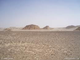
Sol 3's images just in. All in glorious colour!
page: 1share:
mars.jpl.nasa.gov...
There you have it folks. All in colour too. All I can say is "wow!".
Some stunning vista shots. Can't wait for the full resolution one's when they have been compiled!
There you have it folks. All in colour too. All I can say is "wow!".
Some stunning vista shots. Can't wait for the full resolution one's when they have been compiled!
edit on 10-8-2012 by AmatuerSkyWatcher
because: (no reason given)
reply to post by AmatuerSkyWatcher
Err... they went millions of miles to land their Buck Rogers rover..in Barstow? lol....
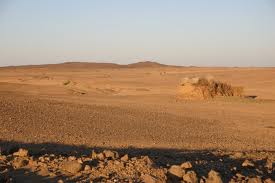
Seriously, was this where they meant to land? I understand safety in not wanting to hit anything..but it looks so barren? Won't they have some real travel distance to get to something more interesting than the field of endless loose stones?
I'm sure they planned all this out...but that is why I ask, is this actually the target landing zone? Thanks anyone who can help.
Err... they went millions of miles to land their Buck Rogers rover..in Barstow? lol....
Seriously, was this where they meant to land? I understand safety in not wanting to hit anything..but it looks so barren? Won't they have some real travel distance to get to something more interesting than the field of endless loose stones?
I'm sure they planned all this out...but that is why I ask, is this actually the target landing zone? Thanks anyone who can help.
reply to post by Wrabbit2000
What's a field of loose stones to you, is a geological gold mine to others. They will be examining the sediments of Mt Sharp in due course.
What's a field of loose stones to you, is a geological gold mine to others. They will be examining the sediments of Mt Sharp in due course.
Thanks for posting
- think we are looking here at remnants of hydrothermal vein
The white looking rocks appear to be silica based with traces of iron
The regolith is heavily oxidised
Very beautiful and very special
- think we are looking here at remnants of hydrothermal vein
The white looking rocks appear to be silica based with traces of iron
The regolith is heavily oxidised
Very beautiful and very special
reply to post by AmatuerSkyWatcher
I appreciate the reply. Heck, after seeing the virtual tour of that rover with all the instruments, drills and cameras highlighted and
explained, I'm very anxious actually. I'll be watching this with great interest for it's whole mission life. I have high hopes this one gets us
something truly new. They sure loaded it with enough gizmos and tools! (crosses paws for good luck)
Interesting...Im gonna go see what this trip cost.
edit on (8/10/1212 by shells4u because: added something
reply to post by magma
Well that mountain didn't just get there all by itself. So I would say you very close to the truth.
There is also evidence to suggest that water probably flowed here too. There are alluvial fans and there is also evidence of scarps in the surrounding environment.
So in the past, this place was volcanically active, probably with geezers and such close by. There was flowing water. The crater walls act just like a valley, so rich mineral run off from rains would be washed into the basin, so you'd end end with a very mineral rich mud in certain locales. Mix these ingredients up, and you have a recipe for life.
Awesome work NASA, top notch location!
Originally posted by Wrabbit2000
reply to post by AmatuerSkyWatcher
Err... they went millions of miles to land their Buck Rogers rover..in Barstow? lol....
Seriously, was this where they meant to land? I understand safety in not wanting to hit anything..but it looks so barren? Won't they have some real travel distance to get to something more interesting than the field of endless loose stones?
I'm sure they planned all this out...but that is why I ask, is this actually the target landing zone? Thanks anyone who can help.
When everyone accepts that mars will turn out very similar to earth all the mystery is gone.
Thankfully this process will prove it
Thanks for the thread / pics.
Looks a lot like AZ. no wonder there are so many aliens in Phoenix.
(Bad joke.)
Really though thanks 4 sharing.
Looks a lot like AZ. no wonder there are so many aliens in Phoenix.
(Bad joke.)
Really though thanks 4 sharing.
Originally posted by AmatuerSkyWatcher
reply to post by magma
Well that mountain didn't just get there all by itself. So I would say you very close to the truth.
There is also evidence to suggest that water probably flowed here too. There are alluvial fans and there is also evidence of scarps in the surrounding environment.
So in the past, this place was volcanically active, probably with geezers and such close by. There was flowing water. The crater walls act just like a valley, so rich mineral run off from rains would be washed into the basin, so you'd end end with a very mineral rich mud in certain locales. Mix these ingredients up, and you have a recipe for life.
Awesome work NASA, top notch location!
In order for oxidisation to occur you need a catylist.
Guess what that was....
Originally posted by AmatuerSkyWatcher
mars.jpl.nasa.gov...
Yeah, very beautifull pictures...but boring. Probably because there is nothing much to see in a dessert.
Still ...I could be terrible wrong of course....but my intuition says there is something wrong with these pictures with a horizon.. The same feel I get with these horizon pictures made by Apollo astronauts on the moon.
reply to post by zatara
You have not looked at rocks and dirt and horizens too much have you
Intuition in your case is mis aligned
Sorry to be the bearer of truth
Maybe you could have another look....
You have not looked at rocks and dirt and horizens too much have you
Intuition in your case is mis aligned
Sorry to be the bearer of truth
Maybe you could have another look....
Originally posted by AmatuerSkyWatcher
reply to post by magma
Exactly. As far as I understand it, you need a volatile ORGANIC compound.
[/q]
As we know it.
One of the most corrosive substances on our planet....
It is vital for life....
It is.....
Originally posted by magma
reply to post by zatara
You have not looked at rocks and dirt and horizens too much have you
Intuition in your case is mis aligned
Sorry to be the bearer of truth
Maybe you could have another look....
Yep...I expected a reply like yours and before posting I did have an other look. Could be nothing of course and you are probably right...... but the feel remains the same....
Acid. Water. Oxygen. Lots .
edit on 10-8-2012 by AmatuerSkyWatcher because: (no reason given)
Something tells me all we will be seeing are pictures of rocks possibly, some cracks on the ground from mountains.
This mission was to test sedimentary rocks and debris.
I would love to see a tall mountain or snow.
This mission was to test sedimentary rocks and debris.
I would love to see a tall mountain or snow.
Nevermind -_-
edit on 10-8-2012 by FermiFlux because: (no reason given)
Originally posted by zatara
Originally posted by AmatuerSkyWatcher
mars.jpl.nasa.gov...
Yeah, very beautifull pictures...but boring. Probably because there is nothing much to see in a dessert.
Still ...I could be terrible wrong of course....but my intuition says there is something wrong with these pictures with a horizon.. The same feel I get with these horizon pictures made by Apollo astronauts on the moon.
The atmospheres less dense than on earth so thats why the views in the distance are similar to the moons.
Mars Surface density: ~0.020 kg/m3 Earth the density of air at sea level is about 1.2 kg/m3
edit on 10-8-2012 by wmd_2008 because: (no reason
given)
new topics
-
Which chapter of the apocalypse is raining fish?
Jokes, Puns, & Pranks: 2 hours ago -
Sweet Home Alabama (metal cover by Leo Moracchioli)
Music: 4 hours ago -
FBI confirms new leads connected to DNA evidence and cellphone data in disturbing killings of elderl
Other Current Events: 7 hours ago -
Moyes No Longer Blowing Bubbles
World Sports: 7 hours ago -
Breaking--Hamas Accepts New Cease Fire
Middle East Issues: 7 hours ago -
Soros, Rockefeller and Pritzker, according to a POLITICO analysis Back Palestinian protests
US Political Madness: 7 hours ago -
Tornado Obliterates Nebraska Building with Furious Anger
Fragile Earth: 8 hours ago -
They say justice is blind.
Religion, Faith, And Theology: 8 hours ago -
Liberal Democrats to Table a Motion of No Confidence in the government Tomorrow
Regional Politics: 10 hours ago -
Time Traveler Caught on Camera?
Paranormal Studies: 10 hours ago
top topics
-
Medvedev: “No one can hide, a global catastrophe is coming”
World War Three: 11 hours ago, 17 flags -
Trump legal cases are falling apart at break neck speeds
US Political Madness: 11 hours ago, 16 flags -
We are screwed
Global Meltdown: 11 hours ago, 14 flags -
Soros, Rockefeller and Pritzker, according to a POLITICO analysis Back Palestinian protests
US Political Madness: 7 hours ago, 12 flags -
Breaking--Hamas Accepts New Cease Fire
Middle East Issues: 7 hours ago, 10 flags -
Tornado Obliterates Nebraska Building with Furious Anger
Fragile Earth: 8 hours ago, 6 flags -
Time Traveler Caught on Camera?
Paranormal Studies: 10 hours ago, 6 flags -
FBI confirms new leads connected to DNA evidence and cellphone data in disturbing killings of elderl
Other Current Events: 7 hours ago, 5 flags -
Liberal Democrats to Table a Motion of No Confidence in the government Tomorrow
Regional Politics: 10 hours ago, 5 flags -
Sweet Home Alabama (metal cover by Leo Moracchioli)
Music: 4 hours ago, 4 flags
active topics
-
Candidate TRUMP Now Has Crazy Judge JUAN MERCHAN After Him - The Stormy Daniels Hush-Money Case.
Political Conspiracies • 1283 • : xuenchen -
Breaking--Hamas Accepts New Cease Fire
Middle East Issues • 57 • : Hasken -
Soros, Rockefeller and Pritzker, according to a POLITICO analysis Back Palestinian protests
US Political Madness • 15 • : SteamyAmerican -
Time Traveler Caught on Camera?
Paranormal Studies • 29 • : Hasken -
Trump legal cases are falling apart at break neck speeds
US Political Madness • 36 • : Terpene -
-@TH3WH17ERABB17- -Q- ---TIME TO SHOW THE WORLD--- -Part- --44--
Dissecting Disinformation • 831 • : fringeofthefringe -
HOUSE VOTES 320-91 TO BAN CHRISTIAN BELIEFS IN AMERICA
Political Issues • 69 • : Daughter2v2 -
Liberal Democrats to Table a Motion of No Confidence in the government Tomorrow
Regional Politics • 9 • : RAY1990 -
Medvedev: “No one can hide, a global catastrophe is coming”
World War Three • 180 • : lostgirl -
Messages of Hope – Unity through AI
Dreams & Predictions • 15 • : Hasken