It looks like you're using an Ad Blocker.
Please white-list or disable AboveTopSecret.com in your ad-blocking tool.
Thank you.
Some features of ATS will be disabled while you continue to use an ad-blocker.

Anyone watching the Dopplar Radar over North America? Looks fishy...
page: 1share:
www.intellicast.com...
Looking at this radar it appears the corn belt has been blocked from getting any moisture and what moisture would be getting there is building around what looks like an invisible barrier. I've been watching dopplar radar for quite a while and I've never seen anything quite like this.
What do you guys think? Is there manipulation here to cause a food crisis? My gut doesn't feel right about this....
edit on 10-7-2012 by
peponastick because: (no reason given)
it's about as non-suspicious as hurricane katrina making a 90 degree turn right at the last minute, hitting new orleans.
reply to post by peponastick
I'm seeing a large portion of the map showing the weather moving East to West. In small areas, I've seen this before. We all have, I'm sure.
Across an entire region? Well, I was under it a few days ago here in Southern Missouri and it was one of the weirdest storms I've ever experienced. I
wasn't alone as a good part of my street turned out to see what was happening with the wind blowing backward in the time before the rain came. Then
it was violent and made for quite a time listening to the local police scanner while sitting without power for a few hours.
I don't know if this is manipulation or what. When the East Coast had people saying it was like nothing they'd seen with that last big one, I figured they just hadn't seen a major thunderstorm before or something. It went well beyond that...and I agree. That map looks...well, wrong.
I don't know if this is manipulation or what. When the East Coast had people saying it was like nothing they'd seen with that last big one, I figured they just hadn't seen a major thunderstorm before or something. It went well beyond that...and I agree. That map looks...well, wrong.
reply to post by peponastick
It looks as the moisture bands are following the jetstream as per usual but thats just the extent of what they taught me in grade 12 geography from a decade ago
www.intellicast.com...
If you follow the path of the stream you will see that the weather is backed up against it while high pressure is keeping a large swath warm and dry.... Least thats what im seeing
SaneThinking
reply to post by peponastick
Apparently I'm getting hunger paigns just from the thought of a food crisis...explains the whole "gut" thing.
It's so weird not seeing a jet stream moving things along.
-Pep
Apparently I'm getting hunger paigns just from the thought of a food crisis...explains the whole "gut" thing.
It's so weird not seeing a jet stream moving things along.
-Pep
I just remembered I had this.
Real Time / Near Real Time Winds over North America
Weird... Thats all I can say. Just...weird. The term doldrums comes to mind, but this is over land, not the ocean.
With everything else, I guess strange has become relative.
*Added Note: I've been sitting here watching the real time wind graphics...and what is going on?? That is literally the entire national air mass moving from the East to the West and halting at or just west of Denver. The West coast looks normal...until it gets to mid-Nevada from the other direction. ????
edit on 10-7-2012 by Wrabbit2000 because: (no reason given)
reply to post by SaneThinking
But there isn't any real direction things are just spreading out in all directions (which could explain the unusal backward wind described in the post above). I'm no expert but that moisture doesn't seem to follow the direction of the jet stream.
But there isn't any real direction things are just spreading out in all directions (which could explain the unusal backward wind described in the post above). I'm no expert but that moisture doesn't seem to follow the direction of the jet stream.
Originally posted by SaneThinking
reply to post by peponastick
www.intellicast.com...
it looks like this is actually a forecast for tomorrow, however this map has a more current view, followed by a forecast. www.weatherimages.org...
that appears like the bulk of the jet stream is much more north of the US...
reply to post by peponastick
I really am not too sure whether the weather is an act of nature and/or some man-made techniques have been mixed in. I am suspicious too.
I know that many crops have been damaged and a food crisis is certainly on its way.
Here is a 50 state weather map of temperatures: www.usairnet.com...
I really am not too sure whether the weather is an act of nature and/or some man-made techniques have been mixed in. I am suspicious too.
I know that many crops have been damaged and a food crisis is certainly on its way.
Here is a 50 state weather map of temperatures: www.usairnet.com...
edit on 10-7-2012 by caladonea because: add more
Originally posted by peponastick
www.intellicast.com...
Looking at this radar it appears the corn belt has been blocked from getting any moisture and what moisture would be getting there is building around what looks like an invisible barrier. I've been watching dopplar radar for quite a while and I've never seen anything quite like this.
What do you guys think? Is there manipulation here to cause a food crisis? My gut doesn't feel right about this....edit on 10-7-2012 by peponastick because: (no reason given)
Keep watching and ignore the naysayers...
Once you pinpoint where some of the "strange weather" is stemming from you'll know it isn't an "Act of God"...
reply to post by ambient moon
It's almost as if the storms energy is intesifing around the drought zone.
It's almost as if the storms energy is intesifing around the drought zone.
reply to post by ambient moon
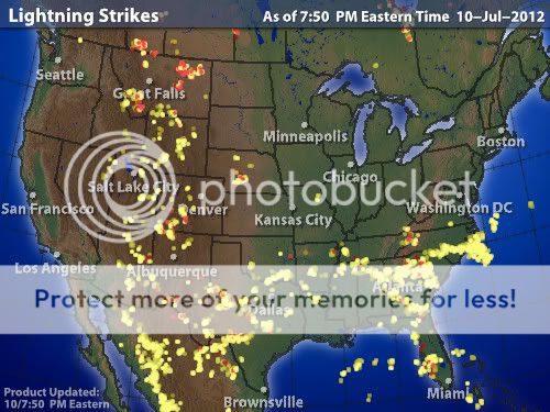
wow that's a pretty textbook 90 degree right angle, even in lightning map, matching the rain map. all the way down to new mexico & texas, it is now...
wow that's a pretty textbook 90 degree right angle, even in lightning map, matching the rain map. all the way down to new mexico & texas, it is now...
reply to post by peponastick
We had the warmest winter on record, hardly any snow in these regions which causes warming of the atmosphere and hotter summers. The polar jet
stream is just about where is should be, could be alittle lower, but as I said, the fact that we had no snow and a very warm winter, these conditions
are causing a warmer than normal summer. SNow plays an important part in keeping the planet cooler during the summer months, the faster the earth
heats up means the faster heat traps in the atmosphere. None of these conditions come as a surpize and were expected with this solar cycle. It is
going to one for the records for sure.
The "invisible barrier" is a high pressure system centered over the Great Lakes. It is forecast to move toward the east, increasing the probability
of precipitation.
reply to post by bwcawaterbear
I'm sure it's just another typical weather pattern...nothing to see here move along.
I'm sure it's just another typical weather pattern...nothing to see here move along.
It is down to a temporary shift in Jet Streams patterns which happens from time to time, for a variety of reasons. A leading contender this time could
well be less sea ice coverage in the Arctic at the moment.
However, crop warfare is a reality and something that America that perpetrated for years, for example the "Banana Wars" during the 1950's (at least Bob Dole did well from it). Hate using Wiki, but a simple example M115 Bomb
For more info, try any books from my old lecturer Simon Whitby (one of world's foremost experts on Crop Warfare). Dr Simon Whitby
reply to post by peponastick
anyone got anything to say on the storm that hit brisbane australia last year? i'm a brisbane guy and i'ed like to know if there was anything strange going on it was unlike anything i've seen before
anyone got anything to say on the storm that hit brisbane australia last year? i'm a brisbane guy and i'ed like to know if there was anything strange going on it was unlike anything i've seen before
new topics
-
Shocking Number of Voters are Open to Committing Election Fraud
US Political Madness: 25 minutes ago -
Gov Kristi Noem Shot and Killed "Less Than Worthless Dog" and a 'Smelly Goat
2024 Elections: 1 hours ago -
Falkville Robot-Man
Aliens and UFOs: 1 hours ago -
James O’Keefe: I have evidence that exposes the CIA, and it’s on camera.
Whistle Blowers and Leaked Documents: 2 hours ago -
Australian PM says the quiet part out loud - "free speech is a threat to democratic dicourse"...?!
New World Order: 2 hours ago -
Ireland VS Globalists
Social Issues and Civil Unrest: 3 hours ago -
Biden "Happy To Debate Trump"
Mainstream News: 3 hours ago -
RAAF airbase in Roswell, New Mexico is on fire
Aliens and UFOs: 4 hours ago -
What is the white pill?
Philosophy and Metaphysics: 5 hours ago -
Blast from the past: ATS Review Podcast, 2006: With All Three Amigos
Member PODcasts: 6 hours ago
top topics
-
A Warning to America: 25 Ways the US is Being Destroyed
New World Order: 13 hours ago, 21 flags -
Biden "Happy To Debate Trump"
Mainstream News: 3 hours ago, 8 flags -
Mike Pinder The Moody Blues R.I.P.
Music: 6 hours ago, 7 flags -
Blast from the past: ATS Review Podcast, 2006: With All Three Amigos
Member PODcasts: 6 hours ago, 7 flags -
What is the white pill?
Philosophy and Metaphysics: 5 hours ago, 5 flags -
James O’Keefe: I have evidence that exposes the CIA, and it’s on camera.
Whistle Blowers and Leaked Documents: 2 hours ago, 5 flags -
Australian PM says the quiet part out loud - "free speech is a threat to democratic dicourse"...?!
New World Order: 2 hours ago, 5 flags -
Ireland VS Globalists
Social Issues and Civil Unrest: 3 hours ago, 4 flags -
RAAF airbase in Roswell, New Mexico is on fire
Aliens and UFOs: 4 hours ago, 4 flags -
Putin, Russia and the Great Architects of the Universe
ATS Skunk Works: 9 hours ago, 3 flags
active topics
-
Gov Kristi Noem Shot and Killed "Less Than Worthless Dog" and a 'Smelly Goat
2024 Elections • 24 • : TimBurr -
Falkville Robot-Man
Aliens and UFOs • 4 • : Kurokage -
The functionality of boldening and italics is clunky and no post char limit warning?
ATS Freshman's Forum • 13 • : JonnyC555 -
Candidate TRUMP Now Has Crazy Judge JUAN MERCHAN After Him - The Stormy Daniels Hush-Money Case.
Political Conspiracies • 805 • : Vermilion -
Shocking Number of Voters are Open to Committing Election Fraud
US Political Madness • 1 • : YourFaceAgain -
-@TH3WH17ERABB17- -Q- ---TIME TO SHOW THE WORLD--- -Part- --44--
Dissecting Disinformation • 700 • : Thoughtful3 -
Putin, Russia and the Great Architects of the Universe
ATS Skunk Works • 26 • : RussianTroll -
Re-election Tactic - JOE BIDEN Hints He May Put Books in the Homes of Black People.
2024 Elections • 30 • : WeMustCare -
Australian PM says the quiet part out loud - "free speech is a threat to democratic dicourse"...?!
New World Order • 3 • : Athetos -
Biden "Happy To Debate Trump"
Mainstream News • 35 • : WeMustCare