It looks like you're using an Ad Blocker.
Please white-list or disable AboveTopSecret.com in your ad-blocking tool.
Thank you.
Some features of ATS will be disabled while you continue to use an ad-blocker.

Quake Nerds Corner: Magnitudes and Energy.
page: 120
share:
Last month I said "Magnitudes and Energy in the next Quake Nerds Corner on April Fools day." Sorry it is a bit late.
This is of course a highly complex subject and is also an area that causes much confusion. Rather than try and explain in minute detail the intricacies of all the formulae I want to try and give you a guide to the general subject.
It really all started with Charles Richter who we have to thank for the Richter Scale that is so well known and used throughout the world. You can find much information out there about the Richter Scale, all you have to do is Google it
I am going to look at Seismographs and Seismograms next month, but for the time being here is the simplest possible form of seismograph.

Richter's scale measures the amount of movement of the needle and this can then be converted into a 'Magnitude' The more the needle 'wobbles' the bigger the magnitude, at least that is the theory. There is a catch to this however. The Richter Scale was developed in California FOR California. Each area of the world has in effect it's own Richter Scale tailored to the area. So the Richter Scale for California is not the same as the Richter Scale for Iran as an example.
The Richter Scale is also really only good for earthquakes within about 600 miles or so. Beyond that distance earthquakes are teleseisms, tele (distant) seism (from Greek seismos, from seiein to shake). These require a different method of measurement. Of that more in a moment.
A fairly typical representation of the Richter Scale is thus:

Look at the trace at the top and you can see they have marked the 'amplitude' of the signal. The amount the needle wobbles.
On the other side they have marked the arrival of the P-wave (Primary or Pressure) and the S-wave (Secondary or Shear). It is the difference between these two waves that gives us the approximate distance to the earthquake. I am not going to go into focal depths and azimuths and how the depth is determined as it is too complex and, well let's be honest, there is no great need to know.
When a fault ruptures (that is what causes the earthquake) the seismic waves radiate out from it. I will look at this in more depth next month. The first wave to arrive is the Primary wave. The ubiquitous Wikipedia says:
For a very quick calculation I tend to use 8km/second. Bear in mind that the speed of sound is around about 340 metres per second. The P-wave is travelling at around 28,800 kilometres and hour, or about 17,895 miles an hours OR MACH 23.5
The S-wave is a slow Joe by comparison, something like 60% of the speed of a P-wave so typically from 2 to 5 km/second. Make no mistake though @2km/second it is still no sluggard as that is 7200km per hour or just under Mach 6.
There are lots more waves from earthquakes including the cutely named Love waves which frankly you don't want loving you!! Read about Love waves and more here
So, back to the calcs. Because there is a difference we can use that to calculate distance. In simple terms if the difference between the two waves is 10 seconds and the speeds are 8 and 5 kms respectively it is easy to see that the earthquake is 30km away. 8-5 = 3km per second. Multiplied by 10 = 30.
The further away from the instrument the earthquake is the less it will move the needle so you can see there is a relationship between the 'amplitude' and the 'distance'.
Back to the image and you can see that if you draw a line on the nomogram from the amplitude to the P-S distance it reads Mag 5 on the centre scale. So now we have a way of calculating the magnitude, but what does that actually mean. The truthful answer is that is does not 'mean' anything as it is just scale, and these days one of many, but it is an indication of the severity of the earthquake.
Note that the scale on the image only goes to 6. Surely it should go up to at least 9? Well no actually. The Richter scale is considered to be saturated above Magnitude 6 or thereabouts, in other words the original Woods Anderson seismometers were maxed out. Modern instruments could cope with that but they are not the instruments on which the scale was based.
The question is often asked, what would that Mag 6 have been if it had been at 10km depth instead of 70km depth. The answer is of course the same. But this does introduce the concept of the shaking, and another scale called the Mercalli scale. Like the Richter scale the Mercalli scale is specific to an area due to the geology. Many of you will know that the New Madrid region is more susceptible than the west coast, and the same goes for Mexico City and Canterbury, NZ. It is because these areas are on rocks strata that are susceptible to amplifying the shaking. Rocks such as shales and shingles will do this. New Madrid is all shales as are many areas east of the Rockies/Sierras. (Hence all the fracking) The USA sits on a shale basin from the GOM to Canada and central (US) America is about the most susceptible.
Generally the scale is like this:

For a comparison of how that matches the Richter Scale for Kansas look at this.

It would only take a 7.7 to be into the most intensive shaking and 8.4 would blow it completely. However, as any Alaskan will tell you, or even Chilean, they eat Mag 7 earthquakes for breakfast so it really does depend on the geology of your area.
In terms of the effect at ground level the Mercalli Intensity scale is a better measure. A Mercalli 7 is a Mercalli 7 everywhere, except in Japan, where the shindo scale is used and is a shaking scale from 0 to 7.
We have shaking and Richter scales, but we know that Richter is not so effective above Mag 6. So what is used?
If you are looking at USGS or EMSC the two most likely candidates will be mb and mw. Mb is calculated on the P-wave. In fact mb is calculated on the 4-5 second periods of the P-wave arrival, at least that was the original method. These days it may be calculated on 1-second P wave periods. It should be fairly obvious that this has the distinct possibility of giving erroneous results. You see when the USGS/EMSC change from mb to Mw in the first hour of the quake they are changing between these two scales generally for the larger quakes. This may also represent a change in the strength of the earthquake either up or down as well, but not always.

Here is how the scales compare
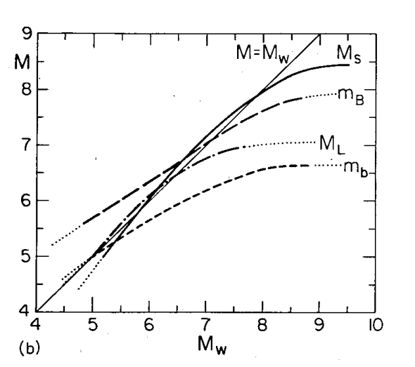
Image from Kanamori: Magnitude Scale and Quantification of Eartrhquakes(PDF)
Kanamori by the way is the inventor of the Mw scale.
...continued
This is of course a highly complex subject and is also an area that causes much confusion. Rather than try and explain in minute detail the intricacies of all the formulae I want to try and give you a guide to the general subject.
It really all started with Charles Richter who we have to thank for the Richter Scale that is so well known and used throughout the world. You can find much information out there about the Richter Scale, all you have to do is Google it
I am going to look at Seismographs and Seismograms next month, but for the time being here is the simplest possible form of seismograph.
Richter's scale measures the amount of movement of the needle and this can then be converted into a 'Magnitude' The more the needle 'wobbles' the bigger the magnitude, at least that is the theory. There is a catch to this however. The Richter Scale was developed in California FOR California. Each area of the world has in effect it's own Richter Scale tailored to the area. So the Richter Scale for California is not the same as the Richter Scale for Iran as an example.
The Richter Scale is also really only good for earthquakes within about 600 miles or so. Beyond that distance earthquakes are teleseisms, tele (distant) seism (from Greek seismos, from seiein to shake). These require a different method of measurement. Of that more in a moment.
A fairly typical representation of the Richter Scale is thus:
Look at the trace at the top and you can see they have marked the 'amplitude' of the signal. The amount the needle wobbles.
On the other side they have marked the arrival of the P-wave (Primary or Pressure) and the S-wave (Secondary or Shear). It is the difference between these two waves that gives us the approximate distance to the earthquake. I am not going to go into focal depths and azimuths and how the depth is determined as it is too complex and, well let's be honest, there is no great need to know.
When a fault ruptures (that is what causes the earthquake) the seismic waves radiate out from it. I will look at this in more depth next month. The first wave to arrive is the Primary wave. The ubiquitous Wikipedia says:
Typical values for P-wave velocity in earthquakes are in the range 5 to 8 km/s. The precise speed varies according to the region of the Earth's interior, from less than 6 km/s in the Earth's crust to 13 km/s through the core.
For a very quick calculation I tend to use 8km/second. Bear in mind that the speed of sound is around about 340 metres per second. The P-wave is travelling at around 28,800 kilometres and hour, or about 17,895 miles an hours OR MACH 23.5
The S-wave is a slow Joe by comparison, something like 60% of the speed of a P-wave so typically from 2 to 5 km/second. Make no mistake though @2km/second it is still no sluggard as that is 7200km per hour or just under Mach 6.
There are lots more waves from earthquakes including the cutely named Love waves which frankly you don't want loving you!! Read about Love waves and more here
So, back to the calcs. Because there is a difference we can use that to calculate distance. In simple terms if the difference between the two waves is 10 seconds and the speeds are 8 and 5 kms respectively it is easy to see that the earthquake is 30km away. 8-5 = 3km per second. Multiplied by 10 = 30.
The further away from the instrument the earthquake is the less it will move the needle so you can see there is a relationship between the 'amplitude' and the 'distance'.
Back to the image and you can see that if you draw a line on the nomogram from the amplitude to the P-S distance it reads Mag 5 on the centre scale. So now we have a way of calculating the magnitude, but what does that actually mean. The truthful answer is that is does not 'mean' anything as it is just scale, and these days one of many, but it is an indication of the severity of the earthquake.
Note that the scale on the image only goes to 6. Surely it should go up to at least 9? Well no actually. The Richter scale is considered to be saturated above Magnitude 6 or thereabouts, in other words the original Woods Anderson seismometers were maxed out. Modern instruments could cope with that but they are not the instruments on which the scale was based.
The question is often asked, what would that Mag 6 have been if it had been at 10km depth instead of 70km depth. The answer is of course the same. But this does introduce the concept of the shaking, and another scale called the Mercalli scale. Like the Richter scale the Mercalli scale is specific to an area due to the geology. Many of you will know that the New Madrid region is more susceptible than the west coast, and the same goes for Mexico City and Canterbury, NZ. It is because these areas are on rocks strata that are susceptible to amplifying the shaking. Rocks such as shales and shingles will do this. New Madrid is all shales as are many areas east of the Rockies/Sierras. (Hence all the fracking) The USA sits on a shale basin from the GOM to Canada and central (US) America is about the most susceptible.
Generally the scale is like this:
For a comparison of how that matches the Richter Scale for Kansas look at this.
It would only take a 7.7 to be into the most intensive shaking and 8.4 would blow it completely. However, as any Alaskan will tell you, or even Chilean, they eat Mag 7 earthquakes for breakfast so it really does depend on the geology of your area.
In terms of the effect at ground level the Mercalli Intensity scale is a better measure. A Mercalli 7 is a Mercalli 7 everywhere, except in Japan, where the shindo scale is used and is a shaking scale from 0 to 7.
We have shaking and Richter scales, but we know that Richter is not so effective above Mag 6. So what is used?
If you are looking at USGS or EMSC the two most likely candidates will be mb and mw. Mb is calculated on the P-wave. In fact mb is calculated on the 4-5 second periods of the P-wave arrival, at least that was the original method. These days it may be calculated on 1-second P wave periods. It should be fairly obvious that this has the distinct possibility of giving erroneous results. You see when the USGS/EMSC change from mb to Mw in the first hour of the quake they are changing between these two scales generally for the larger quakes. This may also represent a change in the strength of the earthquake either up or down as well, but not always.
Here is how the scales compare
Image from Kanamori: Magnitude Scale and Quantification of Eartrhquakes(PDF)
Kanamori by the way is the inventor of the Mw scale.
...continued
All the initial values will be mb (Moment of body wave magnitude) but rather like the Richter scale this too suffers from saturation beyond around 6
mb to 6.5 mb. In fact all the scales other than Ms and Mw have saturation problems, and even Ms has some.
Mw is just a representation of the dynes centimetres of energy. As such it is in many ways, no all ways, a more accurate representation of the quake in my opinion. Ms is very similar, but all the others fall short in some way. So yes you can use mb for some - the average larger quake in the 6 range but if becomes less accurate over the 7 mark.
Bear in mind that mb and ms/mw measure different things. Mb is moment of body magnitude and is the scale developed to measure deep focus earthquakes, and equates to ML hence the similar cut off point of accuracy. It measures the P wave. Ms is the surface wave magnitude and Mw is moment magnitude which are not quite the same thing in terms of measurement but approximate best.
Also remember that Ms, since it measures the surface wave (see above), may be determined considerably later than Mb.
You can find more of this in Earthquake Size
If your brain feels a bit battered don't worry. Just remember that mb comes first and is a 'quick fix'. Mw comes later and is a direct measure of the energy of the earthquake.
So, energy then. What about energy?
I have to push my own personal feeling which is that the energy that is released in a system is what is important, and not the number of earthquakes. Now that is not 100% true because the number of earthquakes do have a bearing on what is going on and swarms of earthquakes can be significant. Swarms are often, but not always, associated with some sort of volcanic activity or with movement of the earth that causes multiple smaller ruptures. You can think of swarms resulting from hydraulic fracturing as a non-volcanic example if you like.)
So what of numbers. Well for example the Magnitude 7.2 in Baja California in 2010 was in round figures about 29 times stronger than ALL of the 25,000 or so earthquakes that followed.
I have taken the last 7 days of earthquakes so as to have a random selection rather than trying to fudge a list. This is the listing of Mag 4.0+ earthquakes over the past 7 days as at 20:30 BST (19:30 UTC) on 10 Apr 2012

We have 71 Magnitude 4.0 to 4.9 representing 71% of the total. But the energy is < 12% of the total.
There are 15 Mag 5.0 to 5.9 representing 17.24% of the total numbers but nearly 50% of the energy output
There is a single Mag 6.2 with just over one percent of the numbers but 41%+ of the energy.
Now here is where it gets interesting. Let's say the next earthquake was a 6.5. What would that compare to.
The answer is that the single 6.5 would release more energy than ALL of the above earthquakes!

Because all these scales are logarithmic it takes (just under) 32 mag 5.0 earthquakes to release the same energy as a single mag 6 earthquake.
The mag 6 is 10 times bigger than the mag 5 but 32 times stronger. The bigger in this instance refers to the amplitude of the quake and strength refers to the energy released by the rupture.
It is logarithmic so therefore it takes the energy of 1000 mag 5 earthquakes to make a mag 7, or about 32 mag 5 quakes to make a mag 6.
It takes some getting your head round just how powerful the bigger quakes are.

It is a very sobering thought that the single Magnitude 9.1 earthquake in Japan last year @2,818 Petajoules of energy was the major part of the 3030 Petajoules of energy released last year. That one single quake released over 13 times the total energy of every other earthquake during the whole of 2011 added together.
Despite that the value of the remaining 212 Petajoules, had it occurred as a single earthquake, would have been just an 8.351 Magnitude. All the quakes in the world (mag 5+) last year = just an 8.351 excluding the 9.1 in Japan.
By the way you can use this calculator to turn Magnitudes into Joules of energy. For most of my calculations I use the value (formulae) at the bottom of this page. It may not be 100% right but it is 100% consistent!
Mw is just a representation of the dynes centimetres of energy. As such it is in many ways, no all ways, a more accurate representation of the quake in my opinion. Ms is very similar, but all the others fall short in some way. So yes you can use mb for some - the average larger quake in the 6 range but if becomes less accurate over the 7 mark.
Bear in mind that mb and ms/mw measure different things. Mb is moment of body magnitude and is the scale developed to measure deep focus earthquakes, and equates to ML hence the similar cut off point of accuracy. It measures the P wave. Ms is the surface wave magnitude and Mw is moment magnitude which are not quite the same thing in terms of measurement but approximate best.
Also remember that Ms, since it measures the surface wave (see above), may be determined considerably later than Mb.
You can find more of this in Earthquake Size
If your brain feels a bit battered don't worry. Just remember that mb comes first and is a 'quick fix'. Mw comes later and is a direct measure of the energy of the earthquake.
So, energy then. What about energy?
I have to push my own personal feeling which is that the energy that is released in a system is what is important, and not the number of earthquakes. Now that is not 100% true because the number of earthquakes do have a bearing on what is going on and swarms of earthquakes can be significant. Swarms are often, but not always, associated with some sort of volcanic activity or with movement of the earth that causes multiple smaller ruptures. You can think of swarms resulting from hydraulic fracturing as a non-volcanic example if you like.)
So what of numbers. Well for example the Magnitude 7.2 in Baja California in 2010 was in round figures about 29 times stronger than ALL of the 25,000 or so earthquakes that followed.
I have taken the last 7 days of earthquakes so as to have a random selection rather than trying to fudge a list. This is the listing of Mag 4.0+ earthquakes over the past 7 days as at 20:30 BST (19:30 UTC) on 10 Apr 2012
We have 71 Magnitude 4.0 to 4.9 representing 71% of the total. But the energy is < 12% of the total.
There are 15 Mag 5.0 to 5.9 representing 17.24% of the total numbers but nearly 50% of the energy output
There is a single Mag 6.2 with just over one percent of the numbers but 41%+ of the energy.
Now here is where it gets interesting. Let's say the next earthquake was a 6.5. What would that compare to.
The answer is that the single 6.5 would release more energy than ALL of the above earthquakes!
Because all these scales are logarithmic it takes (just under) 32 mag 5.0 earthquakes to release the same energy as a single mag 6 earthquake.
The mag 6 is 10 times bigger than the mag 5 but 32 times stronger. The bigger in this instance refers to the amplitude of the quake and strength refers to the energy released by the rupture.
It is logarithmic so therefore it takes the energy of 1000 mag 5 earthquakes to make a mag 7, or about 32 mag 5 quakes to make a mag 6.
It takes some getting your head round just how powerful the bigger quakes are.
It is a very sobering thought that the single Magnitude 9.1 earthquake in Japan last year @2,818 Petajoules of energy was the major part of the 3030 Petajoules of energy released last year. That one single quake released over 13 times the total energy of every other earthquake during the whole of 2011 added together.
Despite that the value of the remaining 212 Petajoules, had it occurred as a single earthquake, would have been just an 8.351 Magnitude. All the quakes in the world (mag 5+) last year = just an 8.351 excluding the 9.1 in Japan.
By the way you can use this calculator to turn Magnitudes into Joules of energy. For most of my calculations I use the value (formulae) at the bottom of this page. It may not be 100% right but it is 100% consistent!
edit on 10/4/2012 by PuterMan because: (no reason given)
Finally just a quick note about some of the scare mongers.
You will see people spouting about the likelihood of a Mag 9 in California, or on the New Madrid. As far as I am concerned anyone who says this has little idea of how things work. Some insist that the 1811/12 New Madrid earthquakes were mag 9 or mag 9.5 because of the damage, blowholes etc. This is demonstrating a distinct lack of knowledge in the subject. As I have shown for example in Kansas a Mag 7.7 would be completely devastating as it would be a Mercalli XII. The current estimate of the New Madrid quakes at around that level (7.7/7.9) I believe to be an accurate assessment for the reasons stated. You have to separate the shaking intensity and the magnitude in your mind.
As far as California is concerned historical record shows us that a mid range Magnitude 8 could be possible in Northern California as a result of the rupture of the southern end of Cascadia. This fault is a subduction zone, whereas the San Andreas is not. The probability is that at a top end mag 7 you are on the upper limit for California, so again prophets of doom spouting M9 quakes for California are just charlatans.
Don't forget that I am not saying that the effects would not be bad as patently they would. That is all down to the shaking intensity.
Someone touting a Mag 9 in Chile would get my attention purely because this is a subduction zone, has a history of such quakes and has the potential to do so again.
If you missed last months Quake Nerds Corner: Understanding Earthquakes you can read it here.
edit on 10/4/2012 by PuterMan because: (no reason given)
Thanks for the info you presented. I'll have to take my time reading it to digest everything. I've often wondered how this all worked.
Thank you sooooo much! I've been reading the QW threads for a while and it can be a bit daunting trying to figure everything out. I do appreciate the
lesson. It certainly helps in the brain organizing department!
Thank you, nice thread.
Another thing to put things in to perspectiv.
The Haiti 2010 7.0 earthquake killed 200.000 people.
The Japan 2011 9.0 earthquake killed 20.000 people, mostly due to the tsunami.
The high magnitude isn't allways the factor of how bad an earthquake is, the position, depth, and people preparedness can change a lot.
Thank you for a fascinating and educational thread,
Immense gratitude from an interested learner about this subject.
Appreciate the work and time you put into explaining things so well and in such a straightforward way S&F.
Immense gratitude from an interested learner about this subject.
Appreciate the work and time you put into explaining things so well and in such a straightforward way S&F.
reply to post by HumansEh
Thank you. I do try not to make the subjects too complex.
As I said further up the thread Seismographs and seismograms next time but you may need the grey matter functional for that one!!
Thank you. I do try not to make the subjects too complex.
As I said further up the thread Seismographs and seismograms next time but you may need the grey matter functional for that one!!
Thanks for the lesson, professor. Perhaps you might answer a question that has always confused me.
What is the difference (in percent energy released) between, say a 5.1 and a 5.2 quake? In other words, is there a general rule of thumb that says that for every 0.1 increase in magnitude, there is an x% increase in "powerfulness"?
You mention above that an M6 is 31.6 times more powerful than an M5. That would seem to indicate that a 0.1 magnitude increase relates to about 3.2 times more power released (or a 220% increase). But the scale is logarithmic so it must be some factor other than 3.2. What is it?
reply to post by Shadoefax
If you look in my signature you will see Magnitude Calcs. That will hopefully answer some of your questions. 0.2 roughly doubles the energy release.
The calculation that I use is general on to give me joules from magnitude. I won't go into the ramifications as to why this is not always accurate but think scales.
The formula is 10^(4.8+(magnitude*1.5)) from the top of my head.
Forgot to add, sorry for the delay in replying and note the bigger than table in those calcs. That is the amplitude of the quake. A mag 5 for example is 10 times bigger then a Mag 4 but 32 times stronger.
Some bloggers do not appreciate the difference.
What is the difference (in percent energy released) between, say a 5.1 and a 5.2 quake? In other words, is there a general rule of thumb that says that for every 0.1 increase in magnitude, there is an x% increase in "powerfulness"?
If you look in my signature you will see Magnitude Calcs. That will hopefully answer some of your questions. 0.2 roughly doubles the energy release.
The calculation that I use is general on to give me joules from magnitude. I won't go into the ramifications as to why this is not always accurate but think scales.
The formula is 10^(4.8+(magnitude*1.5)) from the top of my head.
Forgot to add, sorry for the delay in replying and note the bigger than table in those calcs. That is the amplitude of the quake. A mag 5 for example is 10 times bigger then a Mag 4 but 32 times stronger.
Some bloggers do not appreciate the difference.
edit on 16/4/2012 by PuterMan because: (no reason given)
reply to post by PuterMan
Hi Puterman. Just wanted to let you know I am eagerly awaiting your next installment on seismograms.
May I request a future instructional on earthquake faulting and focal mechanisms? I still finding myself muddling around trying to visiualize exactly what has happened during a rupture.
For instance, this Norwegian Sea Mag 6.2. If i'm reading the diagram correctly, it was a normal style fault (one block slipped down relative to the other). Where I get confused is the big picture. At 8.8km depth, at the hypocenter, the earthquake begins. How far above and below this point does the earth rupture? All the way to the surface, and then another 8.8 km below?
If it does not rupture all the way to the surface, what does it look like? Is it just a big 'rip' or 'tear' inside the upper, solid mantle? Does one side "sag" relative to the other, since it was a normal style fault? Does that "sag" eventually migrate to the top of the ocean floor?
Sheesh, I need to go back to school...unless Puterman University is opening soon on ATS. (fingers crossed)
originally posted by: Olivine
reply to post by PuterMan
Hi Puterman. Just wanted to let you know I am eagerly awaiting your next installment on seismograms.
May I request a future instructional on earthquake faulting and focal mechanisms? I still finding myself muddling around trying to visiualize exactly what has happened during a rupture.
Sheesh, I need to go back to school...unless Puterman University is opening soon on ATS. (fingers crossed)
I'm still mulling the idea of going back to school, but I'm holding out hope for a seat at Puterman College.
(changed from Puterman University--no one wants a geology degree from PU--stinky.)
I know your are always busy PM, so I'm going to give this a try.
The earthquake focal mechanisms, or "beach balls", stumped me for the longest time.
Today, my understanding has improved to the point that I feel comfortable sharing my technique for deciphering the buggers. So, if anyone is interested, here goes:
Oli's guide to beach balls, complete with really lame MS paint diagrams.
From the USGS link above:
Seismologists refer to the direction of slip in an earthquake and the orientation of the fault on which it occurs as the focal mechanism. They use information from seismograms to calculate the focal mechanism and typically display it on maps as a "beach ball" symbol.
The USGS link has some fancy diagrams and examples, which is a nice reference, but not easy to understand at first glance. (or in my case, the 2nd, 3rd, and 4th tries left me still stumped).
Let me try this using an example. Yesterday, there was a small mag 2.8 earthquake just south of the San Andreas fault. This is the associated beachball.

The beachball gives a quick, visual clue to decipher the type of movement generated by the earthquake. In this case, it is oblique-thrust: both horizontal--one side of the fault scraping past the other, and vertical-- with one side moving upward, relative to the other.
The key to visualizing the orientation and type of movement in detail, uses the numbers listed to the left: the nodal planes.
Nearly every earthquake has what is known as a double-couple solution; one possible scenario perpendicular to the other. To decide which version, or nodal plane, most accurately describes the motion, requires looking at nearby faults, topography (ie. mountains), and the historical fault mechanisms in the area.
Since the epicenter is very near the SAF, and one of the nodal plane solutions is pointing in approximately the same direction as the San Andreas, I'm going to use nodal plane #2 for the example. *
*(The EQ could be described by Nodal Plane #1....I don't know for sure...NP#2 is my best guess.)
The Strike is the 1st number given. It corresponds to the compass heading of the fault. In our example, that is 302°.

The Strike is always read just like the headings on a compass:
East = 90
South =180
Northwest = 315
The second number in the nodal plane is the Dip. Dip represents the slope of the fault plane. In our example, that number is 61°.
Pretend you are standing where the stick-figure in the image above is standing, and you are looking in the direction of the strike. (following the blue arrow)
From that position take an elevator straight down into the earth, to the depth of the hypocenter. This is the 61° fault angle, or dip, you would see.

The dip is measured from 0°, which would be like one sheet of paper on a table sliding over the top of another--a completely horizontal fault plane, to 90°--a perfectly vertical fault.
The dip always refers to the "side" to the right of the strike.
You can think of the blue Strike arrow as a hinge, with the Dip plane falling down and to the right. Does that make sense?
I've added the old mining terms "footwall" and "hanging wall" to the diagram--you may run into them. If you stepped out of the imaginary elevator & into a mine shaft on the fault plane, this is what it would look like.
(looking from behind stick-dude)
The third number in the nodal plane solution is the Rake, or slip. It describes the direction of movement of the hanging wall, relative to the footwall. Said another way, the direction the land on the Right side of the fault plane moves--relative to the land on the left.
Let's go back to the map:

Now I need to you to stand out near Hollister, looking back toward the epicenter. The Rake in our example is 163°.

In our example, the land that you are standing on in Hollister, moved up (a bit), and to your left--relative to the land on the Pacific side of the fault.
When the value given for the Rake (or Slip) is positive, that always indicates upward motion .
A negative rake always indicates downward motion; the land to the right of the fault plane sliding down.
A rake close to 0° (positive or negative) means the land to the right of the fault moved in the direction of the strike.
A rake value near 180°(postive or negative) means the land to the right of the fault moved opposite the strike direction.
I know this is confusing, but I hope it helps others to understand the beach balls. Ask any questions--I'll try my best to help.
Just remember, the Hanging wall is always to the right of the Strike, or fault plane.
The Dip is always measured down, and to the right of the Strike direction.
The Rake is always measured with 0° equal to the Strike direction (imagine standing off to the right of the strike, looking back toward the epicenter. 0° will always be off to the right, +/-180° will be off to your left.)
edit on 5/13/2014 by Olivine because: small refinements
edit on 5/13/2014 by Olivine because: more revisions, attempting
clarity
new topics
-
Armadillos moving north
Fragile Earth: 12 minutes ago -
Million dollar idea, and good for your feelz!
Rant: 37 minutes ago -
Is there a dependence on the number of children in the family and its well-being?
New World Order: 46 minutes ago -
Barron Trump has prior commitments?
Mainstream News: 6 hours ago -
Is Taco Bell Satanic?
Education and Media: 9 hours ago -
Scientists Find 7 potential Dyson spheres after Scanning 5 million Objects
Space Exploration: 10 hours ago
top topics
-
REAL ID now a reality
General Conspiracies: 16 hours ago, 8 flags -
Scientists Find 7 potential Dyson spheres after Scanning 5 million Objects
Space Exploration: 10 hours ago, 6 flags -
US 'Uniparty' officially throws Christians to the lions...
Conspiracies in Religions: 14 hours ago, 5 flags -
Is Taco Bell Satanic?
Education and Media: 9 hours ago, 3 flags -
Need help understanding the evolution of WHO as a power structure. Shades of the NWO...?
New World Order: 12 hours ago, 2 flags -
Barron Trump has prior commitments?
Mainstream News: 6 hours ago, 2 flags -
The geography of Eden
Religion, Faith, And Theology: 13 hours ago, 1 flags -
Million dollar idea, and good for your feelz!
Rant: 37 minutes ago, 1 flags -
Is there a dependence on the number of children in the family and its well-being?
New World Order: 46 minutes ago, 0 flags -
Armadillos moving north
Fragile Earth: 12 minutes ago, 0 flags
active topics
-
Is there a dependence on the number of children in the family and its well-being?
New World Order • 5 • : Disgusted123 -
Barron Trump has prior commitments?
Mainstream News • 18 • : Disgusted123 -
Million dollar idea, and good for your feelz!
Rant • 3 • : network dude -
Armadillos moving north
Fragile Earth • 0 • : network dude -
Modern Mind Control
General Conspiracies • 65 • : AllisVibration -
Multipal Solar Storms Coming Our Way This Weekend
Fragile Earth • 33 • : FlyersFan -
Woman In Her 60s Stabbed To Death In London Street By Thief Who Tried To Steal Her Bag.
Social Issues and Civil Unrest • 33 • : angelchemuel -
Bibi’s Dilemma
Middle East Issues • 147 • : Lazy88 -
President Bidens Health is Declining Faster 5.8.2024 - He Should Stay Home.
2024 Elections • 35 • : burritocat -
US 'Uniparty' officially throws Christians to the lions...
Conspiracies in Religions • 20 • : VariedcodeSole
20