It looks like you're using an Ad Blocker.
Please white-list or disable AboveTopSecret.com in your ad-blocking tool.
Thank you.
Some features of ATS will be disabled while you continue to use an ad-blocker.

A Serious Discussion On The Cascadia Subduction Zone and Latest Studies
page: 8share:
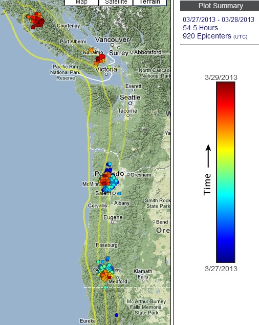
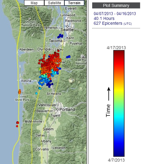
Yesterday's tremor--continuing on strongly west of Portland (where this episode originally began).
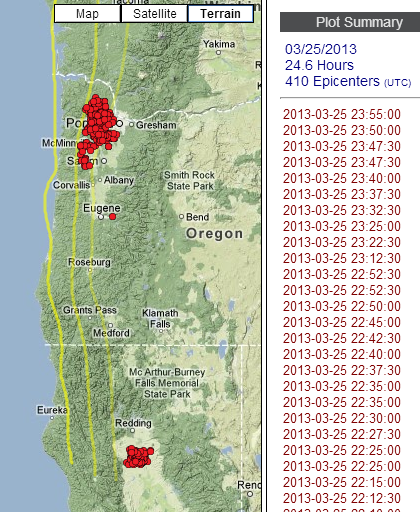
tremor map
We just had another small EQ mag 3.4 near the northern California coast--due west of tremor patch yesterday.
Interestingly, the technical page shows both a strike-slip and thrust solution for first motion mechanisms. They have the mag 4.3 from the 24th as a strike-slip.
Here is a link to the presentation given in Menlo Park, 20 March 2013 by Fred Pollitz titled Annual Modulation of Non-Volcanic Tremor in Northern Cascadia.
He talks about the increase in tremor seen under southern Vancouver Island and northern Washington correlating with the driest months of the year. Toward the end of his talk he showed an interesting graphic concerning the difference in stress required to trigger ETS tremor and normal earthquakes.
Just wanted to share.
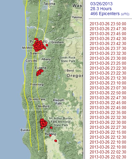
Tremor was even stronger yesterday.
This second image shows the areas of highest density of tremor over the past 30 days. I'm still waiting to see if the tremor moves south to fill the gap between Eugene and Roseburg.
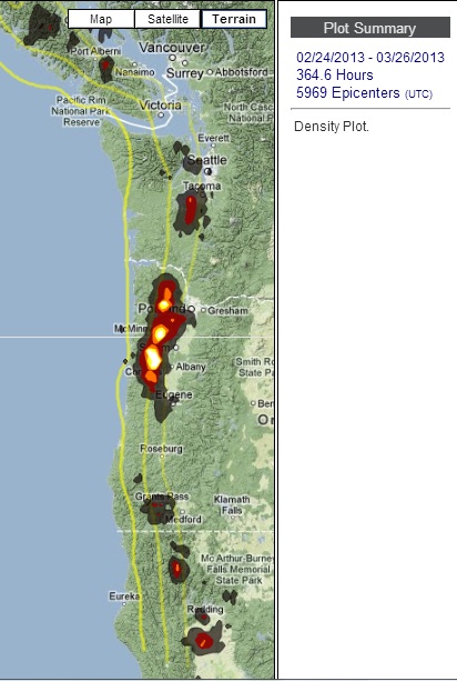
And finally, the 3rd image is only showing tremor in the north and central part of Oregon, over time. This is where slow-slip is being picked up by GPS.
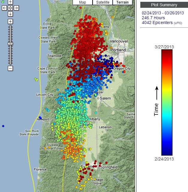
All images generated here.
This second image shows the areas of highest density of tremor over the past 30 days. I'm still waiting to see if the tremor moves south to fill the gap between Eugene and Roseburg.
And finally, the 3rd image is only showing tremor in the north and central part of Oregon, over time. This is where slow-slip is being picked up by GPS.
All images generated here.
reply to post by Olivine
Lots of activity...
I know there needs to be a second.... but I have nothing else to say.
Lots of activity...
I know there needs to be a second.... but I have nothing else to say.
More strong tremor over the past 2 days, and activity has started back up under Vancouver Island. This past month has been strange--the tremor keeps
jumping up and down the entire subduction zone (see 2nd map below).
Yep, here are two maps for comparison. The first one shows the past 30 days of tremor: over 400 hours worth.
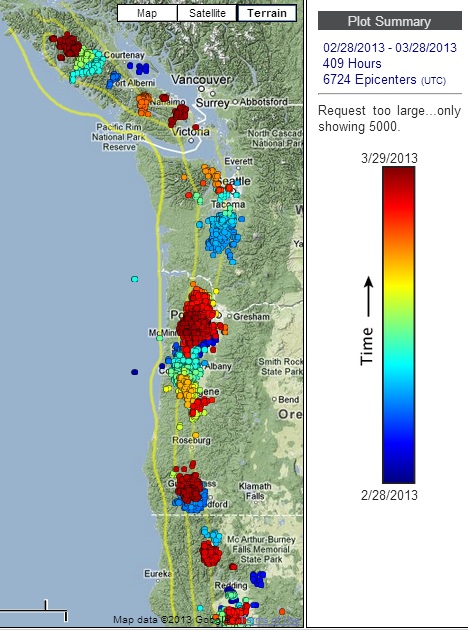
And this image is the previous 30 day period: less than 100 hours when you take out the blob around Portland, which was the beginning of this current episode.
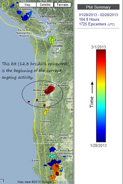
source of all 3 maps
Originally posted by MamaJ
Lots of activity...
Yep, here are two maps for comparison. The first one shows the past 30 days of tremor: over 400 hours worth.
And this image is the previous 30 day period: less than 100 hours when you take out the blob around Portland, which was the beginning of this current episode.
source of all 3 maps
edit on 3/29/2013 by Olivine because: forgot my source
reply to post by Olivine
Central Oregon is making me nervous. Since the tremor started (and slip confirmed), I've seen no actual quakes in the CO area.
That area doesn't see many to begin with but the complete lack of them is disconcerting.
Central Oregon is making me nervous. Since the tremor started (and slip confirmed), I've seen no actual quakes in the CO area.
That area doesn't see many to begin with but the complete lack of them is disconcerting.
reply to post by Olivine
Yeah, when you show it like that within a thirty day time frame and go back the prior month you can tell there is a huge difference. Definitely picking up. Today, equally so it looks like.
Yeah, when you show it like that within a thirty day time frame and go back the prior month you can tell there is a huge difference. Definitely picking up. Today, equally so it looks like.
And no ets swarms are actually due at this time, if it was follwing what has been the reoccuring schedule of every 14 months, give or take 3
months.
edit on 29-3-2013 by AlexanderM because: (no reason given)
Originally posted by NiteNGale2
reply to post by Olivine
Central Oregon is making me nervous. Since the tremor started (and slip confirmed), I've seen no actual quakes in the CO area.
That area doesn't see many to begin with but the complete lack of them is disconcerting.
Thanks for posting.
This is what came up when I searched the USGS EQ archives (47.0 to 42.0 LAT range, -125.25 to -123.75 LON range, mag 4.0 and larger, since 1973)
DATE_TIME LAT LON DEP MAG MT SC
--------------------------------------------------------------------------
2009-02-26 09:52:47.59 42.541 -123.896 39.0 4.0 mb pde
2004-08-19 06:06:03.63 44.665 -124.300 27.9 4.6 mwr pde
2004-07-12 16:45:00.73 44.329 -124.490 29.0 4.9 mwc pde
1989-06-11 12:00:32.92 44.477 -124.895 10.0 4.1 mb pde
1980-08-03 14:43:04.20 42.498 -124.560 15.0 4.5 mb pde
You're right, not much shaking. I guess we can be thankful that these ETS release the magnitude equivalent of a 6.0-6.5 earthquake, just over weeks of time.
It makes me nervous, too. I think, of all the CSZ, the area of central/southern Oregon is probably the area "most stuck"--the part keeping the big thrust earthquake from happening. And when this area is experiencing tremor, that means the plate interface from about 25- 40 kms deep is "less stuck" (semi-freely slipping), which puts more strain on the updip plate interface, 0-25kms deep. That's a thin ribbon of rock keeping everything from breaking loose.
@AlexanderM
You are correct, an extended round of tremor is not expected under the northen Washington/Vancouver Island area yet.
But the tremor we are seeing under Oregon, from Portland down toward Roseburg, runs on a 22 +/- 4 month cycle, and according to the pros, it is right on schedule.
edit on 3/29/2013 by Olivine because: crappy typing skills
reply to post by Olivine
Hey Olivine.......You got the latest on the tremor on the west coast??
2nd.
Hey Olivine.......You got the latest on the tremor on the west coast??
2nd.
reply to post by Olivine
Hello Olivine.
Thank you for the update on the ETS!
Bear with me, as I am a noob, but I checked the PNSN website and it looks like there are still jiggles in the Cascadia Subduction Zone. My question is, what is the criteria for these jiggles being considered an ETS episode?
Thank you!
Hello Olivine.
Thank you for the update on the ETS!
Bear with me, as I am a noob, but I checked the PNSN website and it looks like there are still jiggles in the Cascadia Subduction Zone. My question is, what is the criteria for these jiggles being considered an ETS episode?
Thank you!
edit on 10-4-2013 by r4winds because: spelling
reply to post by r4winds
Until Olivine can get back to you, I have a link to a PNSN Blog that has a discussion about your question.
Nice to know that other quake noobs like myself are following along with the tremor maps
Until Olivine can get back to you, I have a link to a PNSN Blog that has a discussion about your question.
Nice to know that other quake noobs like myself are following along with the tremor maps
edit on 10-4-2013 by NiteNGale2 because: (no reason
given)
reply to post by NiteNGale2
Thank you, NiteNGale2. I read the blog but am still a little hazy.
It looks like the tremors occur on the updip and have a consistent speed.
I think we need an "ETS for quake noobs" thread.
Thank you, NiteNGale2. I read the blog but am still a little hazy.
It looks like the tremors occur on the updip and have a consistent speed.
I think we need an "ETS for quake noobs" thread.
reply to post by r4winds
Hi r4winds. Welcome to the discussion.
Thanks for jumping in to answer r4wind's question while I had spaced out , NiteNGale2. This thread needs more action, so I can find it on the first page of this forum.
As I understand it r4winds, random tremor on the subduction interface, can be detected over a few hours, days or even a week or more, and not be considered an ETS.
Not until there is GPS observed movement at the surface, is the jiggling considered a true episode. I believe the folks studying this phenomenon are leaning toward renaming it "slow-slip"; putting more emphasis on the movement, and less on the tremors.
Have you read this good explaination of ETS from Central Washington Univerisity?
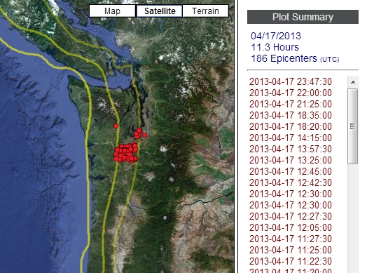
....and speaking of random tremor (that may not be so random); check out the last 2 weeks of action since the mid-Oregon episode was officially declared finished.
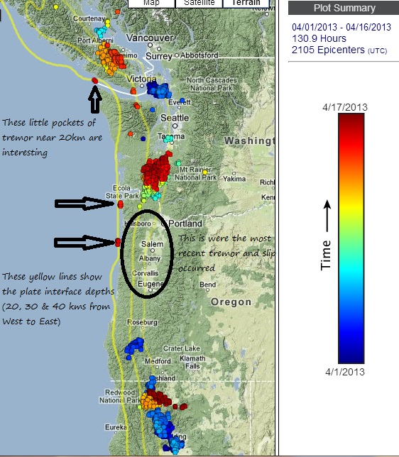
Those few small detected bursts along the 20 km depth are inching oh-so-close to the locked portion of the CSZ.
Let's not forget that tremor are seismic signatures that:
Tremor is picked up when those enormous plates are moving, albeit rather slowly.
My next pic (which can be manufactured from the above link) shows the past 10 days of activity focused on southern Washington and northern Oregon. It looks as if last month's ETS wasn't quite finished, and has decided to trek north.
If you click the past 3,6, and 12 hour links on the real-time map, you can see it is still making a nice push.
IDK, but to me it seems like major parts of the CSZ are "softening up" for some possible major movement. Of course, it could be another 120 years off--we have such a short window of observation.
Hi r4winds. Welcome to the discussion.
Thanks for jumping in to answer r4wind's question while I had spaced out , NiteNGale2. This thread needs more action, so I can find it on the first page of this forum.
As I understand it r4winds, random tremor on the subduction interface, can be detected over a few hours, days or even a week or more, and not be considered an ETS.
Not until there is GPS observed movement at the surface, is the jiggling considered a true episode. I believe the folks studying this phenomenon are leaning toward renaming it "slow-slip"; putting more emphasis on the movement, and less on the tremors.
Have you read this good explaination of ETS from Central Washington Univerisity?
....and speaking of random tremor (that may not be so random); check out the last 2 weeks of action since the mid-Oregon episode was officially declared finished.
Those few small detected bursts along the 20 km depth are inching oh-so-close to the locked portion of the CSZ.
Let's not forget that tremor are seismic signatures that:
source (click the tremor FAQ link)
occur at the plate interface as a direct result of the subducting plate grinding past the overriding plate or they are spread out above the plate boundary possibly occurring on faults that are readjusting in response to stress changes produced by the slow slip on the plate interface below.
Tremor is picked up when those enormous plates are moving, albeit rather slowly.
My next pic (which can be manufactured from the above link) shows the past 10 days of activity focused on southern Washington and northern Oregon. It looks as if last month's ETS wasn't quite finished, and has decided to trek north.
If you click the past 3,6, and 12 hour links on the real-time map, you can see it is still making a nice push.
IDK, but to me it seems like major parts of the CSZ are "softening up" for some possible major movement. Of course, it could be another 120 years off--we have such a short window of observation.
edit on 4/17/2013 by Olivine because: I need to learn to proof read before hitting the "post" button
edit on 4/17/2013 by
Olivine because: and I forgot the 2nd pic
reply to post by Olivine
Thank you, Olivine. Have to read the link to Central Washington University, but I like your explanation the best.
I did notice those jiggles were on the "shallow end" of things. Most swarms I've seen tend to be at the "deep end" at 40 km. Is the ETS wading into the kiddie pool or are we in for a bumpy ride? I'm hoping for simply the former, defintely not the latter.
Again, thank you for the explanation. I'll be in here checking for your updates.
These new tremors are of great concern, as this is what I would expect to see as the fault gets closer to letting go.
reply to post by Olivine
Greetings! My name is Leon and I am new to ATS as a member, but I have been following this topic/thread for quite a while. I am an amateur storm chaser and I follow earthquakes closely as well. My question is, do you think there is a possibility that the tremor activity the past few days around Olympia Washington might be tied into the same mechanism that caused the 2001 Nisqually earthquake as well as others in that general vicinity ex 1965 and 1949 earthquakes. It would have been nice to see a tremor map in the days, weeks, and months before these quakes. I lived around 40 miles northeast of the epicenter of the 2001 quake and it shook pretty strongly where I was. I wonder if another "reminder" is imminent....
Greetings! My name is Leon and I am new to ATS as a member, but I have been following this topic/thread for quite a while. I am an amateur storm chaser and I follow earthquakes closely as well. My question is, do you think there is a possibility that the tremor activity the past few days around Olympia Washington might be tied into the same mechanism that caused the 2001 Nisqually earthquake as well as others in that general vicinity ex 1965 and 1949 earthquakes. It would have been nice to see a tremor map in the days, weeks, and months before these quakes. I lived around 40 miles northeast of the epicenter of the 2001 quake and it shook pretty strongly where I was. I wonder if another "reminder" is imminent....
reply to post by SkywarnPierce4
Hi Leon, and welcome to Westcoast's thread!
The Nisqually quake was an intraplate earthquake--a big snap of the Juan de Fuca plate--probably caused by a volume change in the rock due to pressure and temperature. The tremors are thought to be occurring a bit higher, in the crunching interface along the top of the Juan de Fuca, and the bottom of the North American plates.
So, they are related, but caused by different mechanisms. Hope this helps.
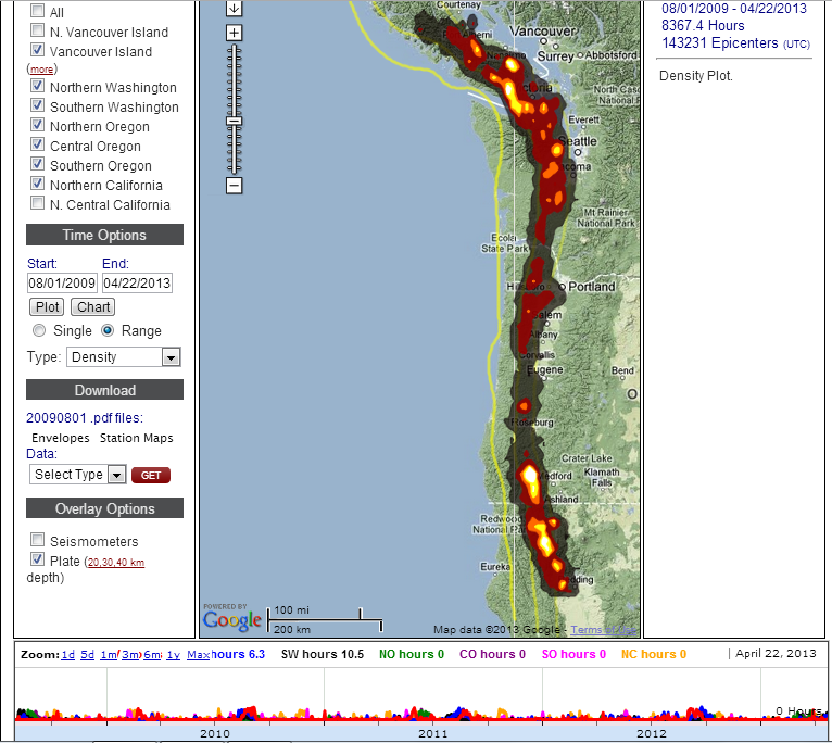
I haven't had much time to peruse quakes lately (which sucks btw ), but I was staring at the interactive tremor map the other night wondering why some areas of the CSZ experience so few tremors, such as central Oregon.
(map shows tremor density over the past 3.75 years)
Then I mapped each "region" seperately, and copied the graphs of each all on one sheet, showing the same 3.75 year period, just looking for patterns.
You can clearly see the major ETS under Vancouver Island (VI) and northern Washington (NW), but as you go south to southern Oregon (SO) and northern California (NC), the tremor seems much more random, and nearly continuous.
The other thing I noticed when looking at the GPS data up and down the subduction zone over the past 7-10 years, is that it is hard to pick out "slip events" in SO and NC. They are very obvious in the north end of the CSZ. (I'll come back and add some GPS graphics soon)
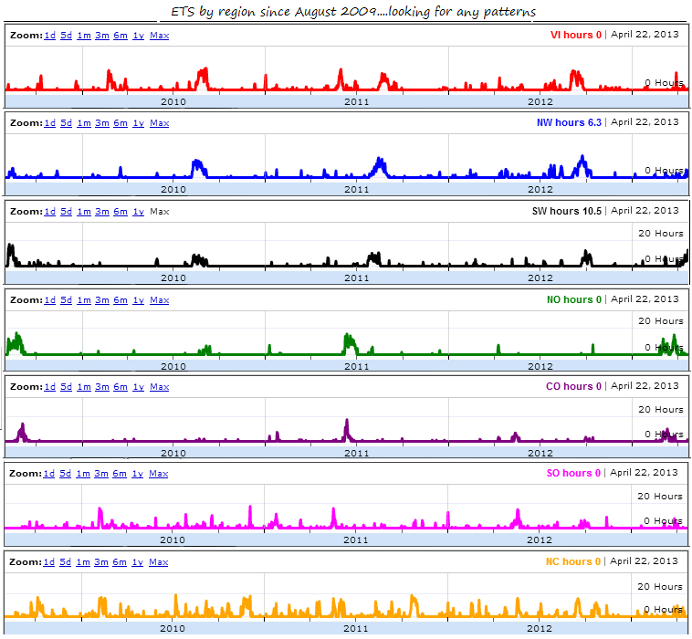
One last thing I noticed is that the area near Medford, OR has more tremor than any other spot over the time covered in the graph. Who knew? I always thought the area near the Olympic mountains was the most active. Maybe it is just the most studied...
Anyway, just thought I would share.
Hi Leon, and welcome to Westcoast's thread!
The Nisqually quake was an intraplate earthquake--a big snap of the Juan de Fuca plate--probably caused by a volume change in the rock due to pressure and temperature. The tremors are thought to be occurring a bit higher, in the crunching interface along the top of the Juan de Fuca, and the bottom of the North American plates.
So, they are related, but caused by different mechanisms. Hope this helps.
I haven't had much time to peruse quakes lately (which sucks btw ), but I was staring at the interactive tremor map the other night wondering why some areas of the CSZ experience so few tremors, such as central Oregon.
(map shows tremor density over the past 3.75 years)
Then I mapped each "region" seperately, and copied the graphs of each all on one sheet, showing the same 3.75 year period, just looking for patterns.
You can clearly see the major ETS under Vancouver Island (VI) and northern Washington (NW), but as you go south to southern Oregon (SO) and northern California (NC), the tremor seems much more random, and nearly continuous.
The other thing I noticed when looking at the GPS data up and down the subduction zone over the past 7-10 years, is that it is hard to pick out "slip events" in SO and NC. They are very obvious in the north end of the CSZ. (I'll come back and add some GPS graphics soon)
One last thing I noticed is that the area near Medford, OR has more tremor than any other spot over the time covered in the graph. Who knew? I always thought the area near the Olympic mountains was the most active. Maybe it is just the most studied...
Anyway, just thought I would share.
reply to post by Olivine
Thank you for sharing your recent research and graphs, Olivine.
I've been on PNSN plotting the dots on the Tremor map and it looks like the jiggles are hanging out in Oregon again and headed a little west toward 30km compared to the preceding days which were closer to 40km. Hopefully all stays quiet in the PNW.
new topics
-
What is the white pill?
Philosophy and Metaphysics: 15 minutes ago -
Mike Pinder The Moody Blues R.I.P.
Music: 59 minutes ago -
Putin, Russia and the Great Architects of the Universe
ATS Skunk Works: 4 hours ago -
A Warning to America: 25 Ways the US is Being Destroyed
New World Order: 8 hours ago
top topics
-
President BIDEN's FBI Raided Donald Trump's Florida Home for OBAMA-NORTH KOREA Documents.
Political Conspiracies: 14 hours ago, 31 flags -
A Warning to America: 25 Ways the US is Being Destroyed
New World Order: 8 hours ago, 14 flags -
Is AI Better Than the Hollywood Elite?
Movies: 15 hours ago, 4 flags -
Mike Pinder The Moody Blues R.I.P.
Music: 59 minutes ago, 2 flags -
Maestro Benedetto
Literature: 15 hours ago, 1 flags -
Putin, Russia and the Great Architects of the Universe
ATS Skunk Works: 4 hours ago, 1 flags -
What is the white pill?
Philosophy and Metaphysics: 15 minutes ago, 1 flags
active topics
-
Meadows, Giuliani Among 11 Indicted in Arizona in Latest 2020 Election Subversion Case
Mainstream News • 17 • : network dude -
New whistleblower Jason Sands speaks on Twitter Spaces last night.
Aliens and UFOs • 69 • : Ophiuchus1 -
Putin, Russia and the Great Architects of the Universe
ATS Skunk Works • 16 • : CristianVictoria -
Alternate Electors vs Fake Electors - What is the Difference.
2024 Elections • 123 • : frogs453 -
Gaza Terrorists Attack US Humanitarian Pier During Construction
Middle East Issues • 61 • : FlyersFan -
Massachusetts Drag Queen Leads Young Kids in Free Palestine Chant
Social Issues and Civil Unrest • 17 • : ToneD -
Hate makes for strange bedfellows
US Political Madness • 51 • : network dude -
The Acronym Game .. Pt.3
General Chit Chat • 7755 • : F2d5thCavv2 -
What is the white pill?
Philosophy and Metaphysics • 0 • : kwaka -
Democrats Introduce Bill That Will Take Away Donald Trumps Secret Service Protection
2024 Elections • 75 • : TzarChasm