It looks like you're using an Ad Blocker.
Please white-list or disable AboveTopSecret.com in your ad-blocking tool.
Thank you.
Some features of ATS will be disabled while you continue to use an ad-blocker.

A Serious Discussion On The Cascadia Subduction Zone and Latest Studies
page: 5share:
reply to post by JohnVidale
I really hope that is what it is. Because that kind of makes me a little uneasy.
Thanks for posting about the glitch factor.
And oldtimer2......get the heck out of this thread. We do not appreciate the likes of your kind of folk up in here
I really hope that is what it is. Because that kind of makes me a little uneasy.
Thanks for posting about the glitch factor.
And oldtimer2......get the heck out of this thread. We do not appreciate the likes of your kind of folk up in here
edit on 11-6-2012 by
radpetey because: (no reason given)
Yes, makes me nervous too. I'm in Vancouver. I was ready to head to Costco and buy additional water and suppies, and if it's not a clitch, I still
will. Please post as soon as you know. This is important!
reply to post by JohnVidale
Hi John. Any more info from Mr. Wech?
I went to the tremor map and noticed that when I run my mouse over the times, the epicenters seem to jump from one cluster to the next, and the next, and so on...south to north then back again. It does look suspicous.
Just out of curiousity, do you recall ever seeing a 'legitimate' spread of tremor along the CSZ , similar to the June 10th map? Did it/would it pique your interest, or cause alarm?
reply to post by Olivine
I tried to pull up the recent epicenters for yesterday and today, but could not manage this simple task
When you get a chance, would you so kindly post an updated map of the epicenters for the last two days??
Radpetey
I tried to pull up the recent epicenters for yesterday and today, but could not manage this simple task
When you get a chance, would you so kindly post an updated map of the epicenters for the last two days??
Radpetey
Yesterday, June 11th shows zero tremor activity. And the 10th still looks like this:
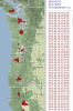 (click to enlarge)
The people at PNSN suspect some sort of error in processing on the 10th, but I haven't read a definitive answer yet. I suspect they are still checking their system. Hope this helps.
 (click to enlarge)
 The people at PNSN suspect some sort of error in processing on the 10th, but I haven't read a definitive answer yet. I suspect they are still checking their system. Hope this helps.
reply to post by radpetey
Hey guys, just noticed your thread.
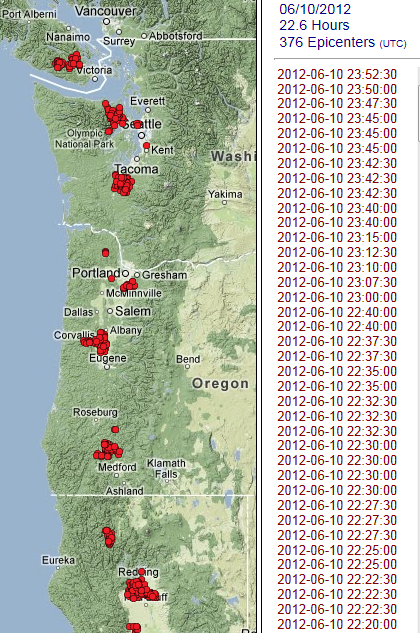
The increased seismicity along the CSZ may be related to the coverup of quakes along nearby plate boundaries; here are two from today that were dropped from the ANF site and never even picked up by the USGS just north of the CSZ:

And one from yesterday:
And more, there is no major plate boundary here that we know of, it could be a stretch zone, and it could influence the CSZ:

All these Pacific Ocean quakes have disappeared from the ANF website and never showed up on the USGS. Yes, as you probably know, there would have to be at least three seismic stations recording the same quake in order to get a triangulation - what is the chance three stations would get identical errors?
Hey guys, just noticed your thread.
The increased seismicity along the CSZ may be related to the coverup of quakes along nearby plate boundaries; here are two from today that were dropped from the ANF site and never even picked up by the USGS just north of the CSZ:
And one from yesterday:
And more, there is no major plate boundary here that we know of, it could be a stretch zone, and it could influence the CSZ:
All these Pacific Ocean quakes have disappeared from the ANF website and never showed up on the USGS. Yes, as you probably know, there would have to be at least three seismic stations recording the same quake in order to get a triangulation - what is the chance three stations would get identical errors?
edit on 12-6-2012 by PlanetXisHERE because: spelling
reply to post by PlanetXisHERE
If this is the case it totally disgusts me. Thanks for the heads up!
Can any of our resident experts confirm the reliability of the source with this info??
If this is the case it totally disgusts me. Thanks for the heads up!
Can any of our resident experts confirm the reliability of the source with this info??
reply to post by PlanetXisHERE
Could you post a link to this website.
It would be greatly appreciated!!
Could you post a link to this website.
It would be greatly appreciated!!
Originally posted by radpetey
reply to post by PlanetXisHERE
Could you post a link to this website.
It would be greatly appreciated!!
Sure, here it is:
anf.ucsd.edu...
Remember how earthquake reporting works, for those of you who don't know, some may, in order for an epicenter to show up on a map like the ones I posted above - at least three seismic stations must have recorded the same seismic wave - they need at least three recordings to triangulate on the epicenter - and it is hugely unlikely three stations would make the same error. Of course EQ's can be upgraded or downgraded by a couple of decimal points, but this is not the same thing - these EQ's are being taken down from the ANF site and not even showing up on other sites.
The main question to ask is why?
It looks like the slightly concerning pattern of ETS from 06/10/2012 was due to a malfunctioning computer.
Aaron Wech, the creator of the tremor page software found here just posted the following blurb on the PNSN facebook group page (login required):
Aaron Wech, the creator of the tremor page software found here just posted the following blurb on the PNSN facebook group page (login required):
Confirmed computer problems. The machine that I grab data from was apparently very very sick, producing data gap and errors that caused all sorts of problems for my codes. Things should be back to normal now, and the processing will be redone and website updated shortly.
reply to post by Olivine
Finally escaped some meetings, and got back to one of my laptops.
Aaron Wech has diagnosed the plague of activity on the 10th as an artifact of telemetry problems. Sometimes tremor activity seems to jump improbable distances in a few days, and sometimes much of the arc is active, but I've never seen the entire Cascadia arc light up on the same day for real.
reply to post by JohnVidale
Thanks John for the update on that....and thanks Oivine for your diligence!!
As to the other source, i really can' say. Perhaps someone else knows? I know quakes are sometimes dropped due to errors or explosions, but I don't usually see them disappear when they originate in the ocean. (moved, yes...location in the ocean is tricky) Curious.
Hi I live in Vancouver and was wondering if the stress build up may be less now on the Northern Cascadia fault area seeing we had a 6.3 last week and
the 6.4 in Sept 2011?
reply to post by Vancouver108
I am a landscape contractor not a geologist. However, I feel all this activity is a little foreshadowing of big things to come.
I hope I am wrong........Oh........!! but I did stay in a Holiday Express last night. For what it's worth
Sure wish John Vidale would rear his professional head and spill some of his precious wisdom on the situation.
It's been a while since I posted in this thread, but I thought I would bring it back to the front page for some input, so here goes.
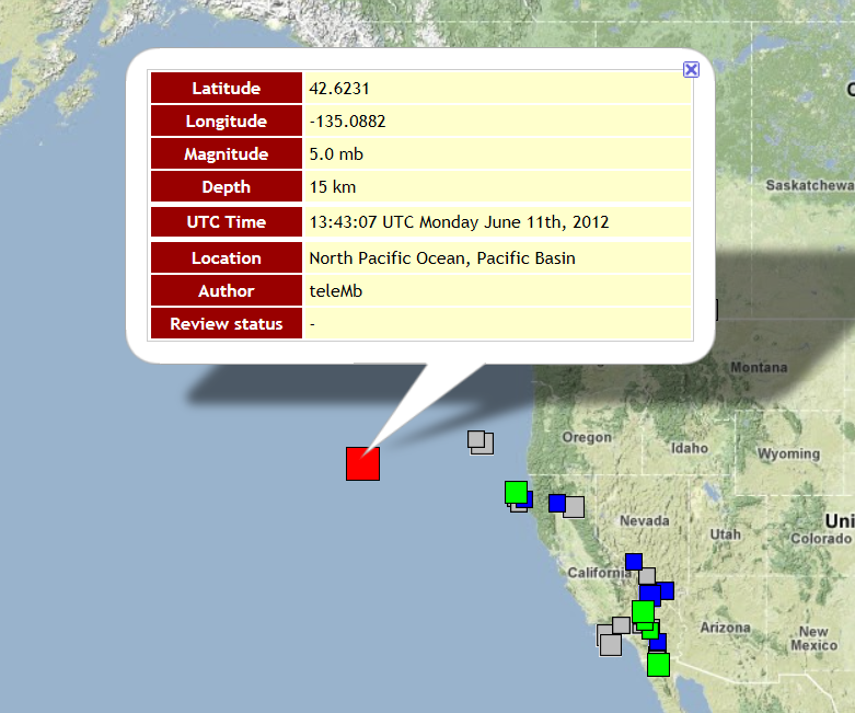
I've noticed that the GPS array situated across the Vancouver Island, B.C./northern Puget Sound, WA region has remained unsettled since the Mag 7.8 Haida Gwaii earthquake 03:04:11 UTC October 28th.
The map below shows the array. map source
Now check out the data.
This link will take you to the Latitude page--showing movement in the North-South direction. (sorry, the page is too large to provide a screen shot)
Almost every station shows a 15 millimeter (1.5 cm) movement to the south over a two-day period. Then a 10 mm rebound to the north the following day. (The best I can tell, this movement occurred over the 22nd, 23rd, and 24th of December.)
Does anyone else think this movement is large? Looking at the graphs prior to the end of October, the GPS positions seem fairly constant. Not stationary, but relatively calm. But to my eye, November and December look like a rollercoaster across the entire region.
Use this link to check out the vertical locations. Just about every station in the array experienced a 20 millimeter (2 cm) drop over the same time period.
No slow-slip (ETS) has been observed in the area over the past week or so, so it is not that.
Umm, I don't know what to make of it, but I wanted to share. Maybe over a longer time frame, these movements will look tame.
Originally posted by Olivine
It's been a while since I posted in this thread, but I thought I would bring it back to the front page for some input, so here goes.
I've noticed that the GPS array situated across the Vancouver Island, B.C./northern Puget Sound, WA region has remained unsettled since the Mag 7.8 Haida Gwaii earthquake 03:04:11 UTC October 28th.
The map below shows the array. map source
Now check out the data.
This link will take you to the Latitude page--showing movement in the North-South direction. (sorry, the page is too large to provide a screen shot)
Almost every station shows a 15 millimeter (1.5 cm) movement to the south over a two-day period. Then a 10 mm rebound to the north the following day. (The best I can tell, this movement occurred over the 22nd, 23rd, and 24th of December.)
Does anyone else think this movement is large? Looking at the graphs prior to the end of October, the GPS positions seem fairly constant. Not stationary, but relatively calm. But to my eye, November and December look like a rollercoaster across the entire region.
Use this link to check out the vertical locations. Just about every station in the array experienced a 20 millimeter (2 cm) drop over the same time period.
No slow-slip (ETS) has been observed in the area over the past week or so, so it is not that.
Umm, I don't know what to make of it, but I wanted to share. Maybe over a longer time frame, these movements will look tame.
It seems that the slow slip has started again
Scroll down to the third story in the link I have posted.
These rumbles usually happen every 15 months. However, they seemed to have started early this time around and now are happening again.
Will try to track down all the details. Someone posted some awesome 3D maps of the quakes earlier this year, and am hoping they will do the same for this recent episode.
theextinctionprotocol.wordpress.com...
edit on 29-12-2012 by radpetey because: Afterthoughts.
Someone from the B.C. area has reported a constant rumbling for the last 24 hours. That is why I posted this. It is posted on the godlikeproductions site.
edit on 29-12-2012 by radpetey because: (no reason given)
Thanks for linking that article. I hadn't read it yet. I see westcoast has also linked it. I've also wondered about the potential for "the" big
subduction slip during a tremor episode. It sounds like the pros are still undecided.
Looking at the realtime tremor map for the PNW, there looks to be a little tremor under northern California. I don't expect to see another full-blown ETS event under the Puget Sound area; the last one just ended on 12 October 2012.
Looking at the realtime tremor map for the PNW, there looks to be a little tremor under northern California. I don't expect to see another full-blown ETS event under the Puget Sound area; the last one just ended on 12 October 2012.
new topics
-
whistleblower Captain Bill Uhouse on the Kingman UFO recovery
Aliens and UFOs: 4 hours ago -
1980s Arcade
General Chit Chat: 6 hours ago -
Deadpool and Wolverine
Movies: 7 hours ago -
Teenager makes chess history becoming the youngest challenger for the world championship crown
Other Current Events: 8 hours ago -
CIA botched its handling of sexual assault allegations, House intel report says
Breaking Alternative News: 9 hours ago -
Lawsuit Seeks to ‘Ban the Jab’ in Florida
Diseases and Pandemics: 11 hours ago
top topics
-
Lawsuit Seeks to ‘Ban the Jab’ in Florida
Diseases and Pandemics: 11 hours ago, 20 flags -
Starburst galaxy M82 - Webb Vs Hubble
Space Exploration: 13 hours ago, 13 flags -
The Superstition of Full Moons Filling Hospitals Turns Out To Be True!
Medical Issues & Conspiracies: 15 hours ago, 8 flags -
CIA botched its handling of sexual assault allegations, House intel report says
Breaking Alternative News: 9 hours ago, 8 flags -
15 Unhealthiest Sodas On The Market
Health & Wellness: 14 hours ago, 6 flags -
whistleblower Captain Bill Uhouse on the Kingman UFO recovery
Aliens and UFOs: 4 hours ago, 6 flags -
Teenager makes chess history becoming the youngest challenger for the world championship crown
Other Current Events: 8 hours ago, 3 flags -
Deadpool and Wolverine
Movies: 7 hours ago, 3 flags -
1980s Arcade
General Chit Chat: 6 hours ago, 3 flags
active topics
-
1980s Arcade
General Chit Chat • 8 • : F2d5thCavv2 -
What is a dream
The Gray Area • 27 • : wrayth -
Europe declares war on Russia?
World War Three • 61 • : F2d5thCavv2 -
The Acronym Game .. Pt.3
General Chit Chat • 7741 • : F2d5thCavv2 -
Russia Ukraine Update Thread - part 3
World War Three • 5713 • : F2d5thCavv2 -
IDF Intel Chief Resigns Over Hamas attack
Middle East Issues • 32 • : Terpene -
15 Unhealthiest Sodas On The Market
Health & Wellness • 32 • : VariedcodeSole -
Fast Moving Disc Shaped UFO Captured on Camera During Flight from Florida to New York City
Aliens and UFOs • 18 • : inflaymes69 -
Definitive 9.11 Pentagon EVIDENCE.
9/11 Conspiracies • 419 • : SchrodingersRat -
They Killed Dr. Who for Good
Rant • 61 • : Cymru