It looks like you're using an Ad Blocker.
Please white-list or disable AboveTopSecret.com in your ad-blocking tool.
Thank you.
Some features of ATS will be disabled while you continue to use an ad-blocker.

A Serious Discussion On The Cascadia Subduction Zone and Latest Studies
page: 7share:
reply to post by radpetey
I know it's hard not to, but don't worry.
I'm sure you have your family up-to-date on their local hazards, and have guided them with their preparations. That's all you can do. It's the price of admission for living in such a beautiful area, unfortunately.
I was just looking at the PNSN facebook group page.
Paul Bodin, PNSN manager, posted the following bit about the current ETS in western Oregon:
So it looks like this area has its own recurrence rate. Interesting.
Sure wish we could figure out why the tremor happens where and when it does, and what it really means for the future mag 8 or 9.
I know it's hard not to, but don't worry.
I'm sure you have your family up-to-date on their local hazards, and have guided them with their preparations. That's all you can do. It's the price of admission for living in such a beautiful area, unfortunately.
I was just looking at the PNSN facebook group page.
Paul Bodin, PNSN manager, posted the following bit about the current ETS in western Oregon:
Appears to be an ETS (episodic tremor and slip) event in NW Oregon. Started a couple of days ago under Portland and has been slowly moving updip and to the southwest. Ken Creager estimates it has accumulated 52 hours of slip so far. Aaron Wech notes that the last slip event here was about 21 months ago, and that Brudzinski & Allen found events in that area recurred at 19 months +/- 3 months. So ... it's about time!
So it looks like this area has its own recurrence rate. Interesting.
Sure wish we could figure out why the tremor happens where and when it does, and what it really means for the future mag 8 or 9.
edit on 3/6/2013 by Olivine because: (no reason given)
edit on 3/6/2013 by Olivine because: (no reason given)
When is the next main ets due, didn't it just end not too long ago?
reply to post by AlexanderM
According to the PNSN's tremor log 2012, the most recent Puget Sound/Vancouver Island episode began 30 August and ended 11 October 2012, with a total 618 hours of tremor.
So, if it were to hold to the 14 month cycle, we really shouldn't expect to see anything until December 2013/January 2014.
But...it could be on a new cycle, closer to 11/12 months. The past few years have begun in:
May 2009
8 Aug 2010
23 July 2011
30 Aug 2012
Prior episodes (2003-2008) were spaced 14-months apart. tremor overview
Hope this helps.
edit on 3/6/2013 by Olivine because: add a link
edit on 3/6/2013 by Olivine because: (no reason given)
edit
on 3/6/2013 by Olivine because: my thoughts are scattered, ugh
Looks like we're edging closer to this becoming a full ets swarm event.
Just wanted to share a new PNSN blog entry devoted to the current tremor
up and down the Cascadia Subduction Zone.
It talks about the relative rarity of tremor located in central Oregon, which got me thinking about why some spots experience so little tremor as compared to others.
Here is a map showing the density of tremor throughout the CSZ over the past 3-1/2 years.
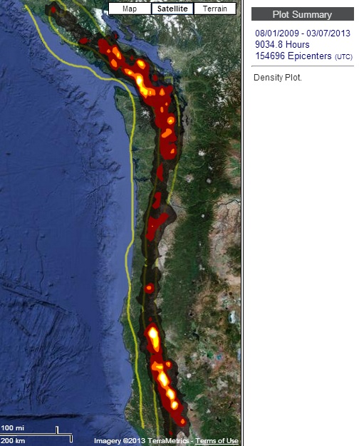
courtesy of PNSN
What is it about this stretch along central Oregon that makes it so quiet?
It talks about the relative rarity of tremor located in central Oregon, which got me thinking about why some spots experience so little tremor as compared to others.
Here is a map showing the density of tremor throughout the CSZ over the past 3-1/2 years.
courtesy of PNSN
What is it about this stretch along central Oregon that makes it so quiet?
edit on 3/9/2013 by Olivine because: (no reason given)
reply to post by Olivine
I was wondering that myself. I was curious about whether or not it was geologically different and found that Central Oregon is the area that makes up one out of three major zones in the CSZ.
Seems there is the Wrangellia to the north, the Siletzia in the middle and the Klamath to the south. Here is what one long paper had to say:
Link. Sorry that it isn't a pdf with page numbers. The article is very long and the part that I posted is a little more than halfway down.
I was wondering that myself. I was curious about whether or not it was geologically different and found that Central Oregon is the area that makes up one out of three major zones in the CSZ.
Seems there is the Wrangellia to the north, the Siletzia in the middle and the Klamath to the south. Here is what one long paper had to say:
For ETS recurrence, the accreted terranes composing the upper plate above ETS generate inherently sizable along-strike variations in structure, composition, and age that are presumably more significant than long-term effects of ETS on upper plate structure. This supports an interpretation where variations in the Wrangellia, Siletzia, and Klamath blocks control behavior of the ETS source zone. A clue to how continental blocks could be responsible for differences in ETS recurrence is geochemical evidence that the different terranes have different fluid content (Schmidt and Grunder, 2006), which could trigger ETS via high pore fluid pressures (Kodaira et al., 2004; Obara, 2002). An intriguing hypothesis is that different terrane composition affects the rheology of the upper plate and hence the plate interface (Kohlstedt et al., 1995). For example, the Siletzia terrane represents denser, stronger, more oceanic crust, while the Klamath terrane represents lighter, weaker, more continental crust. Such a scenario would suggest that the low-lying Siletzia region has a longer recurrence interval because the upper plate has the strength to accumulate strain for longer periods between slow slip episodes.
Link. Sorry that it isn't a pdf with page numbers. The article is very long and the part that I posted is a little more than halfway down.
edit on 9-3-2013 by WillowWisp because: spelling
edit on 9-3-2013 by WillowWisp because:
(no reason given)
reply to post by WillowWisp
What a terrific link!
I will be spending the day digesting this. I'm familiar with the Klamath block, that area is what got me interested in rocks, then geology, in the beginning.
Thanks again for your post WillowWisp.
What a terrific link!
I will be spending the day digesting this. I'm familiar with the Klamath block, that area is what got me interested in rocks, then geology, in the beginning.
Thanks again for your post WillowWisp.
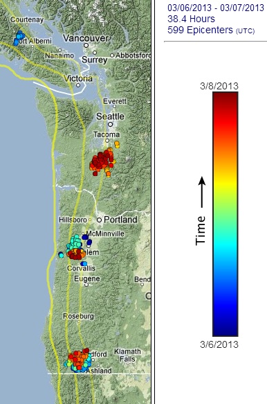
Time for a tremor update. All of the map data is from the PNSN interactive tremor map.
This map is the past 4 days since my last map post:
And this is the map showing this most recent episode over time:
As you can see, the burst of tremor just south of Portland, Oregon has moved south and west over time. The western (up-dip) movement is important during tremor episodes; I'll come back to that.
It's also interesting that Vancouver Island and central Washington have become active again, considering those areas had their longest recorded episode ever, back in the fall 2012.
The 3 yellow lines on the maps indicate the depth of the plate interface (20, 30, & 40 kms--moving west to east) as the Juan de Fuca oceanic plate gets shoved under the North American plate.
The central Oregon burst began fairly deep, around 45 kms down-dip, and has moved up-dip to approximately 25 kms.
Here is an illustrated cross-section of the fault:
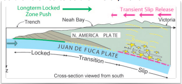 source
After observing repeated ETS events, the geoscientists have concluded that the lower limit of the transition zone is at about 25 kms depth. Their modeling shows the plate interface to be 100% locked up-dip, near 10 km depth. Then the coupling (locked-tight-ness ) drops to only 50% at 25 kms deep. From 25 to 40 kms (the depth of the majority of tremor and slow-slip), the coupling drops rapidly from 50% to only 15%; and below 70 kms the slab is freely slipping into the mantle. (I've paraphrased this info from here.)
Now, the website WillowWisp linked a few posts above, written by W.D. Stanley, of USGS (formerly?) (who published on ETS in 1999), hypothesizes that the central Oregon block (Siletzia terrane) is the main sticking point for the entire fault line. He reasons that because the area is primarily composed of denser, stronger mafic rock, as opposed to the northern and southern ends of the CSZ, the asperities at the plate interface, in this area, are tougher to break.
When a critical percentage of these sticking points crumble, that is when a major earthquake will happen.
He also proposes the following:
Let me put this together:
1. During an ETS event, the stress applied to the "locked zone" is increased, because the interface down-dip is "unlocked" for a short time, allowing the full weight of the down-going slab to "pull" on the locked zone.
2. The 25 kms depth on the interface seems to be the westward, up-dip limit of tremor and slip.
3. If there is strong deviation from "normal" ETS patterns, it could signal the megathrust EQ is near.
So, we should try to establish what the "normal" ETS patterns are, and be on the lookout for radical departures from said patterns. Easy
(If I have misunderstood any of this, or just have it flat out wrong--please set me straight!)
Same area, different topic. I find this small quake interesting. Mag 2.1 Check out the depth--87.4 kilometers?
Ack! I can never get a post right on the first try. Or second.
The current tremor west of Salem and Eugene, Oregon is ongoing. Realtime tremor It is also still moving up-dip, into the transition zone.
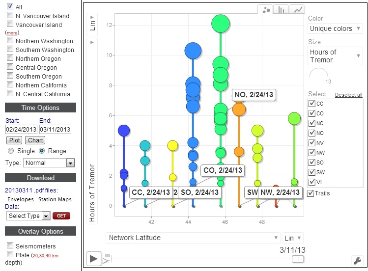
Also, I'm not sure why I've never "clicked" the chart option on the interactive tremor map before, but it is fun!
(well, I'm a geek and easily amused)
This is a screencap of one option.
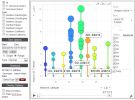
You can set it to show latitude or longitude movement, hours of tremor, # of discrete epicenters, etc, and you can play it as a movie. Check it out.
This map is the past 4 days since my last map post:
And this is the map showing this most recent episode over time:
As you can see, the burst of tremor just south of Portland, Oregon has moved south and west over time. The western (up-dip) movement is important during tremor episodes; I'll come back to that.
It's also interesting that Vancouver Island and central Washington have become active again, considering those areas had their longest recorded episode ever, back in the fall 2012.
The 3 yellow lines on the maps indicate the depth of the plate interface (20, 30, & 40 kms--moving west to east) as the Juan de Fuca oceanic plate gets shoved under the North American plate.
The central Oregon burst began fairly deep, around 45 kms down-dip, and has moved up-dip to approximately 25 kms.
Here is an illustrated cross-section of the fault:
After observing repeated ETS events, the geoscientists have concluded that the lower limit of the transition zone is at about 25 kms depth. Their modeling shows the plate interface to be 100% locked up-dip, near 10 km depth. Then the coupling (locked-tight-ness ) drops to only 50% at 25 kms deep. From 25 to 40 kms (the depth of the majority of tremor and slow-slip), the coupling drops rapidly from 50% to only 15%; and below 70 kms the slab is freely slipping into the mantle. (I've paraphrased this info from here.)
Now, the website WillowWisp linked a few posts above, written by W.D. Stanley, of USGS (formerly?) (who published on ETS in 1999), hypothesizes that the central Oregon block (Siletzia terrane) is the main sticking point for the entire fault line. He reasons that because the area is primarily composed of denser, stronger mafic rock, as opposed to the northern and southern ends of the CSZ, the asperities at the plate interface, in this area, are tougher to break.
When a critical percentage of these sticking points crumble, that is when a major earthquake will happen.
He also proposes the following:
It seems likely that there is a very predictable pattern to the tremor and slip patterns. As time goes on, this web site will try to point out the latest patterns in tremor, earthquakes and slip (when available). If there is a radical departure from the pattern then this might be one signal of a forthcoming megaquake.
Let me put this together:
1. During an ETS event, the stress applied to the "locked zone" is increased, because the interface down-dip is "unlocked" for a short time, allowing the full weight of the down-going slab to "pull" on the locked zone.
2. The 25 kms depth on the interface seems to be the westward, up-dip limit of tremor and slip.
3. If there is strong deviation from "normal" ETS patterns, it could signal the megathrust EQ is near.
So, we should try to establish what the "normal" ETS patterns are, and be on the lookout for radical departures from said patterns. Easy
(If I have misunderstood any of this, or just have it flat out wrong--please set me straight!)
Same area, different topic. I find this small quake interesting. Mag 2.1 Check out the depth--87.4 kilometers?
Ack! I can never get a post right on the first try. Or second.
The current tremor west of Salem and Eugene, Oregon is ongoing. Realtime tremor It is also still moving up-dip, into the transition zone.
Also, I'm not sure why I've never "clicked" the chart option on the interactive tremor map before, but it is fun!
(well, I'm a geek and easily amused)
This is a screencap of one option.
You can set it to show latitude or longitude movement, hours of tremor, # of discrete epicenters, etc, and you can play it as a movie. Check it out.
edit on 3/12/2013 by Olivine because: adding
edit on 3/12/2013 by Olivine because: (no reason given)
edit
on 3/12/2013 by Olivine because: more mistakes
edit on 3/12/2013 by Olivine because: do you ever just have "one of those
days"?
Another ets swarm now is already a radical departure from the 14 month intervals. I would already say that this is of great concern.
Originally posted by Olivine
Time for a tremor update. All of the map data is from the PNSN interactive tremor map.
This map is the past 4 days since my last map post:
And this is the map showing this most recent episode over time:
As you can see, the burst of tremor just south of Portland, Oregon has moved south and west over time. The western (up-dip) movement is important during tremor episodes; I'll come back to that.
It's also interesting that Vancouver Island and central Washington have become active again, considering those areas had their longest recorded episode ever, back in the fall 2012.
The 3 yellow lines on the maps indicate the depth of the plate interface (20, 30, & 40 kms--moving west to east) as the Juan de Fuca oceanic plate gets shoved under the North American plate.
The central Oregon burst began fairly deep, around 45 kms down-dip, and has moved up-dip to approximately 25 kms.
Here is an illustrated cross-section of the fault:
source
After observing repeated ETS events, the geoscientists have concluded that the lower limit of the transition zone is at about 25 kms depth. Their modeling shows the plate interface to be 100% locked up-dip, near 10 km depth. Then the coupling (locked-tight-ness ) drops to only 50% at 25 kms deep. From 25 to 40 kms (the depth of the majority of tremor and slow-slip), the coupling drops rapidly from 50% to only 15%; and below 70 kms the slab is freely slipping into the mantle. (I've paraphrased this info from here.)
Now, the website WillowWisp linked a few posts above, written by W.D. Stanley, of USGS (formerly?) (who published on ETS in 1999), hypothesizes that the central Oregon block (Siletzia terrane) is the main sticking point for the entire fault line. He reasons that because the area is primarily composed of denser, stronger mafic rock, as opposed to the northern and southern ends of the CSZ, the asperities at the plate interface, in this area, are tougher to break.
When a critical percentage of these sticking points crumble, that is when a major earthquake will happen.
He also proposes the following:
It seems likely that there is a very predictable pattern to the tremor and slip patterns. As time goes on, this web site will try to point out the latest patterns in tremor, earthquakes and slip (when available). If there is a radical departure from the pattern then this might be one signal of a forthcoming megaquake.
Let me put this together:
1. During an ETS event, the stress applied to the "locked zone" is increased, because the interface down-dip is "unlocked" for a short time, allowing the full weight of the down-going slab to "pull" on the locked zone.
2. The 25 kms depth on the interface seems to be the westward, up-dip limit of tremor and slip.
3. If there is strong deviation from "normal" ETS patterns, it could signal the megathrust EQ is near.
So, we should try to establish what the "normal" ETS patterns are, and be on the lookout for radical departures from said patterns. Easy
(If I have misunderstood any of this, or just have it flat out wrong--please set me straight!)
Same area, different topic. I find this small quake interesting. Mag 2.1 Check out the depth--87.4 kilometers?
Ack! I can never get a post right on the first try. Or second.
The current tremor west of Salem and Eugene, Oregon is ongoing. Realtime tremor It is also still moving up-dip, into the transition zone.
Also, I'm not sure why I've never "clicked" the chart option on the interactive tremor map before, but it is fun!
(well, I'm a geek and easily amused)
This is a screencap of one option.
You can set it to show latitude or longitude movement, hours of tremor, # of discrete epicenters, etc, and you can play it as a movie. Check it out.edit on 3/12/2013 by Olivine because: addingedit on 3/12/2013 by Olivine because: (no reason given)edit on 3/12/2013 by Olivine because: more mistakesedit on 3/12/2013 by Olivine because: do you ever just have "one of those days"?
Thank you,Olivine,for staying with this thread.
reply to post by kdog1982
It's my pleasure, kdog.
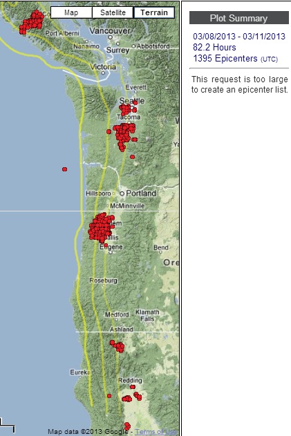
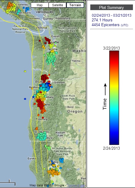
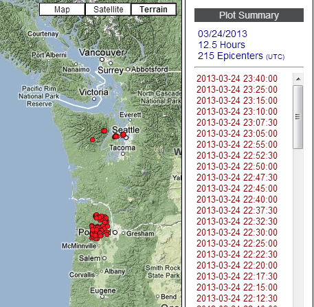
The tremor in central Oregon seems to be fizzling out--it might not make it all the way south to Roseburg, as previous episodes have. The map below shows all the tremor along the CSZ since this episode in Oregon began late last month.
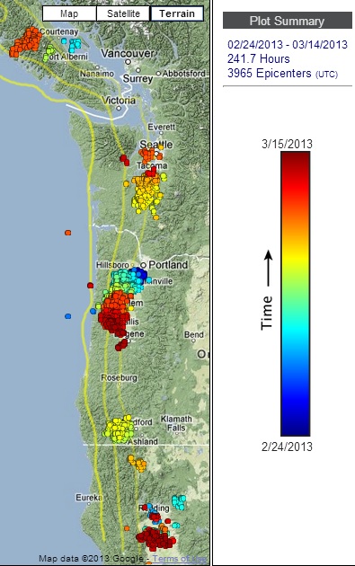
source
On the PNSN facebook group page (login req'd), Aaron Wech, the tremor map creator, was commenting on the current tremor. When asked whether the tremor under Vancouver Island and Seattle was connected to the current action under Oregon, he stated that it probably was not.
But John Vidale had this comment:
I post this to show that the ETS events are not fully understood, and still full of questions to be answered.
It's really quite exciting to follow along as the science becomes more clear about this phenomenon, and how it may relate to the impending megathrust earthquake.
ETA:
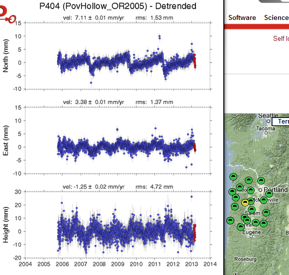
I think we are beginning to see the slow-slip associated with the tremor under central Oregon. This image is a snapshot of the GPS movement (detrended), showing the same south and westward movement as previous episodes in mid 2007, August 2009, and July-Sept 2011.
The small yellow dot on the right of the screencap shows the location of this monument.

(click to enlarge)
GPS data courtesy of unavco
You can also click the "Nearby GPS Plots" link, in the center of the page, to see movement in all of the surrounding areas.
It's my pleasure, kdog.
The tremor in central Oregon seems to be fizzling out--it might not make it all the way south to Roseburg, as previous episodes have. The map below shows all the tremor along the CSZ since this episode in Oregon began late last month.
source
On the PNSN facebook group page (login req'd), Aaron Wech, the tremor map creator, was commenting on the current tremor. When asked whether the tremor under Vancouver Island and Seattle was connected to the current action under Oregon, he stated that it probably was not.
But John Vidale had this comment:
There are suggestions that the tremor activity is too synchronous along Cascadia and elsewhere to be coincidental, but there is no plausible way to link activity. So we await either someone showing the synchronicity is consistent with randomness (the likely outcome) or a connection is demonstrated and explained.
I post this to show that the ETS events are not fully understood, and still full of questions to be answered.
It's really quite exciting to follow along as the science becomes more clear about this phenomenon, and how it may relate to the impending megathrust earthquake.
ETA:
I think we are beginning to see the slow-slip associated with the tremor under central Oregon. This image is a snapshot of the GPS movement (detrended), showing the same south and westward movement as previous episodes in mid 2007, August 2009, and July-Sept 2011.
The small yellow dot on the right of the screencap shows the location of this monument.
(click to enlarge)
GPS data courtesy of unavco
You can also click the "Nearby GPS Plots" link, in the center of the page, to see movement in all of the surrounding areas.
edit on 3/15/2013 by Olivine because: add gps data
edit on 3/15/2013 by Olivine because: wording
Olivine, I have to go over to Victoria next Saturday, so I expect you to make sure that all of this has settled down by then. If I end up right in
the middle of the big one, I am not going to be impressed. lol
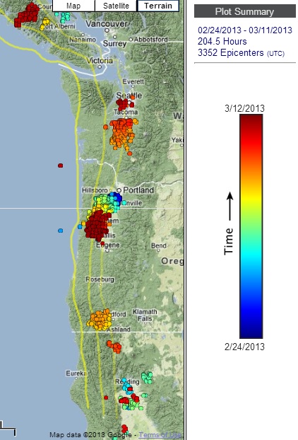
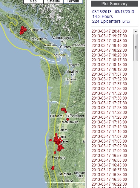
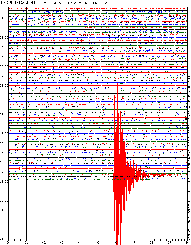
Tremor activity is still hanging on, if only weakly. It has definitely slowed over recent days.
This map shows all of the tremor since the 24th of February, when it began as a decent burst just SW of Portland, Oregon.
www.pnsn.org/tremor
Certainly been jumping around...
This map shows all of the tremor since the 24th of February, when it began as a decent burst just SW of Portland, Oregon.
www.pnsn.org/tremor
Certainly been jumping around...
Hmm, tremor activity ramped back up over the past 2 days...it's not over yet.
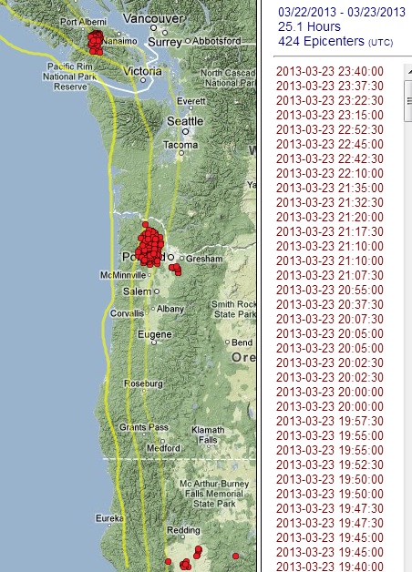
source map
Between the relatively deep mag 3.2 under the Olympic mountains on Friday, and the very shallow earthquakes in southern Oregon this morning (about 40 km SW of Crater Lake), things aren't so seismically boring in the PNW.
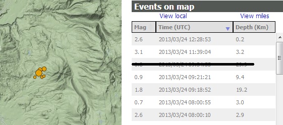
image source (zoomed in)
ETA: I checked the PNSN facebook group to see if there was any additional information on this small swarm & found John Vidale's thoughts:
source map
Between the relatively deep mag 3.2 under the Olympic mountains on Friday, and the very shallow earthquakes in southern Oregon this morning (about 40 km SW of Crater Lake), things aren't so seismically boring in the PNW.
image source (zoomed in)
ETA: I checked the PNSN facebook group to see if there was any additional information on this small swarm & found John Vidale's thoughts:
This same area had little swarms in 2008 and 2011, never getting an event as big as M3, who knows why. Our stations are far enough away that we cannot confidently measure the earthquake depth.
edit on 3/24/2013 by Olivine because: add info
I made it back from Victoria last evening, won't be going back now for a long time, if ever. Was way too close to the water, thought if the big one
hits now, I'm in trouble. Good job Olivine!! Thanks for having my back!!
reply to post by AlexanderM
No problem. I hope you managed to enjoy your visit.
The Pacific Northwest Seismic Network has a new blog post regarding the southern Oregon swarm.
It also looks like they are slowly resolving the depths of the quakes, although with large uncertainties because of the lack of stations nearby.
Here is blurb about Mount McLoughlin, referenced in the blog above, and not far from the current earthquake activity.
ETA:
I thought I would add this earthquake to the mix: Mag 4.3 offshore Ferndale, CA
Very shallow--undersea landslide?
No problem. I hope you managed to enjoy your visit.
The Pacific Northwest Seismic Network has a new blog post regarding the southern Oregon swarm.
It also looks like they are slowly resolving the depths of the quakes, although with large uncertainties because of the lack of stations nearby.
Here is blurb about Mount McLoughlin, referenced in the blog above, and not far from the current earthquake activity.
edit on 3/24/2013 by Olivine because: edit
ETA:
I thought I would add this earthquake to the mix: Mag 4.3 offshore Ferndale, CA
Very shallow--undersea landslide?
edit on 3/24/2013 by Olivine because: add a quake
edit on 3/24/2013 by Olivine because: add image
new topics
-
Electrical tricks for saving money
Education and Media: 53 minutes ago -
VP's Secret Service agent brawls with other agents at Andrews
Mainstream News: 2 hours ago -
Sunak spinning the sickness figures
Other Current Events: 2 hours ago -
Nearly 70% Of Americans Want Talks To End War In Ukraine
Political Issues: 3 hours ago -
Late Night with the Devil - a really good unusual modern horror film.
Movies: 4 hours ago -
Cats Used as Live Bait to Train Ferocious Pitbulls in Illegal NYC Dogfighting
Social Issues and Civil Unrest: 6 hours ago -
The Good News According to Jesus - Episode 1
Religion, Faith, And Theology: 8 hours ago -
HORRIBLE !! Russian Soldier Drinking Own Urine To Survive In Battle
World War Three: 10 hours ago
top topics
-
SETI chief says US has no evidence for alien technology. 'And we never have'
Aliens and UFOs: 17 hours ago, 8 flags -
Cats Used as Live Bait to Train Ferocious Pitbulls in Illegal NYC Dogfighting
Social Issues and Civil Unrest: 6 hours ago, 8 flags -
Florida man's trip overseas ends in shock over $143,000 T-Mobile phone bill
Social Issues and Civil Unrest: 13 hours ago, 8 flags -
VP's Secret Service agent brawls with other agents at Andrews
Mainstream News: 2 hours ago, 6 flags -
Former Labour minister Frank Field dies aged 81
People: 15 hours ago, 4 flags -
Bobiverse
Fantasy & Science Fiction: 13 hours ago, 3 flags -
HORRIBLE !! Russian Soldier Drinking Own Urine To Survive In Battle
World War Three: 10 hours ago, 3 flags -
Nearly 70% Of Americans Want Talks To End War In Ukraine
Political Issues: 3 hours ago, 3 flags -
Sunak spinning the sickness figures
Other Current Events: 2 hours ago, 3 flags -
Late Night with the Devil - a really good unusual modern horror film.
Movies: 4 hours ago, 2 flags
active topics
-
VP's Secret Service agent brawls with other agents at Andrews
Mainstream News • 18 • : burritocat -
SETI chief says US has no evidence for alien technology. 'And we never have'
Aliens and UFOs • 42 • : Boomer1947 -
NASA Researchers Discover a Parallel Universe That Runs Backwards through Time - Alongside Us
Space Exploration • 71 • : charlyv -
Sunak spinning the sickness figures
Other Current Events • 4 • : annonentity -
Cats Used as Live Bait to Train Ferocious Pitbulls in Illegal NYC Dogfighting
Social Issues and Civil Unrest • 12 • : Hakaiju -
HORRIBLE !! Russian Soldier Drinking Own Urine To Survive In Battle
World War Three • 28 • : budzprime69 -
Huge ancient city found in the Amazon.
Ancient & Lost Civilizations • 61 • : Therealbeverage -
The Reality of the Laser
Military Projects • 43 • : 5thHead -
Should Biden Replace Harris With AOC On the 2024 Democrat Ticket?
2024 Elections • 49 • : Therealbeverage -
WF Killer Patents & Secret Science Vol. 1 | Free Energy & Anti-Gravity Cover-Ups
General Conspiracies • 32 • : Arbitrageur