It looks like you're using an Ad Blocker.
Please white-list or disable AboveTopSecret.com in your ad-blocking tool.
Thank you.
Some features of ATS will be disabled while you continue to use an ad-blocker.

West Coast USA: Pay Attention, Cascadia May Be Ready to Rupture
page: 31share:
reply to post by Olivine
The other stations in the area are not showing the same energy as TIMB, so it must either be in the data transmission or a local source of noise.
The other stations in the area are not showing the same energy as TIMB, so it must either be in the data transmission or a local source of noise.
I figure I'll throw this question in here since we have a few knowledgeable heads that poke in from time to time. I've been watching the # storm
that is one of the numerous Mitchell Coombes fan groups on Facebook and I keep seeing mention of the earthquake magnitude scale being revamped
recently. People keep saying that "they" have downgraded everything by one whole point, so what was a 4.0 is now reported as a 3.0. I call horse
hockey. Nobody can give a reliable source for this change, just that "I saw it on some science website, it's true, but I can't find where I read
it now, weird." Yet there's a few of these guys all backing each other up on it saying it's true. They're all posting every 2.0 in California as
if it's a sure sign the predictions are coming true, and claiming the USGS is hiding and downgrading earthquakes so we don't realize that the end is
near or some crap. To be honest I'm not sure how some of these people remember to breathe with all this doom and gloom they're spewing.
It's really been quite a laugh for me and I'm pretty sure these people are full of it, but I thought maybe I should ask somebody who would know for sure just in case I'm making a fool of myself. Has there been any change to the scale recently?
It's really been quite a laugh for me and I'm pretty sure these people are full of it, but I thought maybe I should ask somebody who would know for sure just in case I'm making a fool of myself. Has there been any change to the scale recently?
reply to post by TMG333
The basic magnitude, the moment magnitude, has not changed since it was invented. There are many ways to calculate magnitude, especially for small events, but am not aware of any major shift recently.
The basic magnitude, the moment magnitude, has not changed since it was invented. There are many ways to calculate magnitude, especially for small events, but am not aware of any major shift recently.
Originally posted by JohnVidale
reply to post by Olivine
If you were watching carefully, you might have seen us waffle about whether some quakes were tectonic or highwaymen or quarrymen blowing up stuff, and switched the labels back and forth.
I wasn't watching too carefully, until this morning, lol.
So the magnitude 2.2 located some 36km deep @ 18:53UTC on the 20th of August, is now Mag 1.0 at 0km depth?
Locating these small quakes must drive your group crazy.
I've been following the tremor (er, "ETS proper") discussion on your seismo blog...interesting. It looks like a topic with much more study and many more papers to come in the future.
reply to post by Olivine
Right, that event near Portland I analyzed too quickly just before lunch, and it turns out, while my initial guess could be right, it is much more likely to be an explosion considering the waveforms, the location, and the history in that area.
And we will continue to study tremor closely for at least a few years.
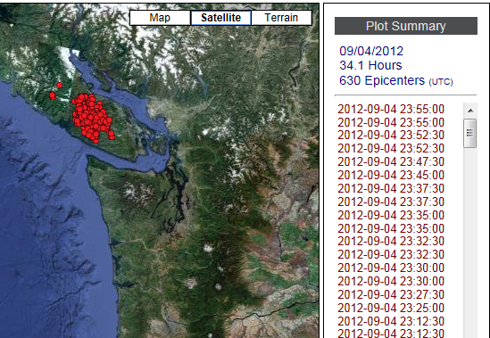
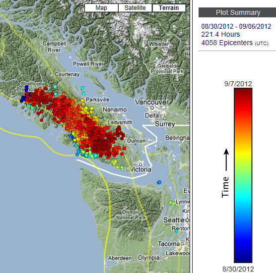
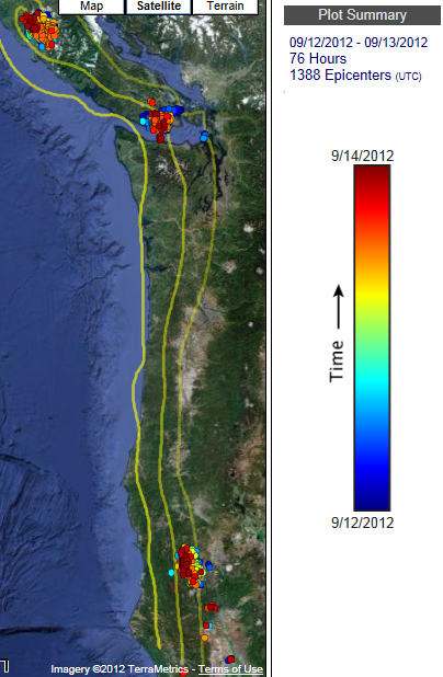
The Pacific Northwest has been quiet over the past few weeks, but a new tremor cluster has been growing since the final days of August.
Here is the map for yesterday; just over 34 hours and 630 epicenters.
And this is the map for the past 6 days, with over 150 hours of slow slip.
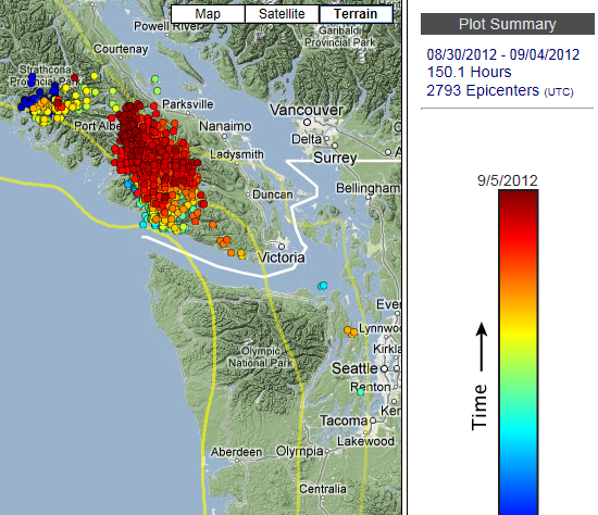
Source for both images is www.pnsn.org...
I'm not certain that this is the beginning of the tremor episode for this year, which is anticipated to begin anytime during the late summer/fall timeframe. But I don't think this is the traditional location. The PNSN has a tremor blog set up for this years' event; I'm waiting for an update to be posted there.
On a related topic, the ETS spectrograms found here haven't been updated since August 20th.
Mr. Vidale, will they be coming back?
Addendum:
I don't think that the CSZ is "ready to rupture" today as this thread title suggests; rather this seems to be the thread that is most often used for posting seismic information for the PNW region.
Although, the scientists studying ETS/'slow slip' do suggest that these episodes can slightly raise the chances of a major rupture.
Here is the map for yesterday; just over 34 hours and 630 epicenters.
And this is the map for the past 6 days, with over 150 hours of slow slip.
Source for both images is www.pnsn.org...
I'm not certain that this is the beginning of the tremor episode for this year, which is anticipated to begin anytime during the late summer/fall timeframe. But I don't think this is the traditional location. The PNSN has a tremor blog set up for this years' event; I'm waiting for an update to be posted there.
On a related topic, the ETS spectrograms found here haven't been updated since August 20th.
Mr. Vidale, will they be coming back?
Addendum:
I don't think that the CSZ is "ready to rupture" today as this thread title suggests; rather this seems to be the thread that is most often used for posting seismic information for the PNW region.
Although, the scientists studying ETS/'slow slip' do suggest that these episodes can slightly raise the chances of a major rupture.
edit on 9/5/2012 by Olivine because: add info
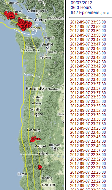
The current slow slip episode is continuing under Vancouver Island; another 40.5 hours and 727 epicenters.
(the pic below reads higher numbers because of a small bit of tremor detected in northern California, which I cropped.)
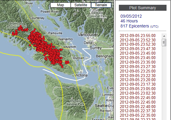
Source link www.pnsn.org...
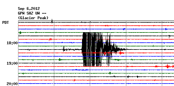
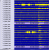
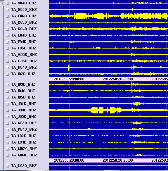
I'm curious to get some input on the seismograms below from Glacier Peak. (3 different views of same events)
New-style webi GPW.EHZ.UW past 24 hours.
Old-style webi GPW.SHZ.UW September 6th, 00:00 to 12:00UTC
IRIS seismo day 250 (Sept 06) GPW.UW..EHZ
What do you make of the event at 01:21 UTC?
 (click to enlarge)
I can't find a regional event or teleseism to tie it to. I've been trying to match the signal to one of these examples from Mt. Rainier:
The earthquake at 03:55UTC on the above links was a Mag 0.9 located about 15 km east of Glacier. It's hard to pick out because this volcano looks really noisy at the moment, especially compared to just a few days ago.
There are some oddball looking signals--are they just icequakes and avalanches?
(Just when I think I'm getting the hang of understanding these seismos, I'm handed a huge plate of humble pie)
The winds have been mild nearby. NWAC--Dirty Face Mtn weather
(the pic below reads higher numbers because of a small bit of tremor detected in northern California, which I cropped.)
Source link www.pnsn.org...
I'm curious to get some input on the seismograms below from Glacier Peak. (3 different views of same events)
New-style webi GPW.EHZ.UW past 24 hours.
Old-style webi GPW.SHZ.UW September 6th, 00:00 to 12:00UTC
IRIS seismo day 250 (Sept 06) GPW.UW..EHZ
What do you make of the event at 01:21 UTC?
 (click to enlarge)
 I can't find a regional event or teleseism to tie it to. I've been trying to match the signal to one of these examples from Mt. Rainier:
The earthquake at 03:55UTC on the above links was a Mag 0.9 located about 15 km east of Glacier. It's hard to pick out because this volcano looks really noisy at the moment, especially compared to just a few days ago.
There are some oddball looking signals--are they just icequakes and avalanches?
(Just when I think I'm getting the hang of understanding these seismos, I'm handed a huge plate of humble pie)
The winds have been mild nearby. NWAC--Dirty Face Mtn weather
edit on 9/6/2012 by Olivine because: add info
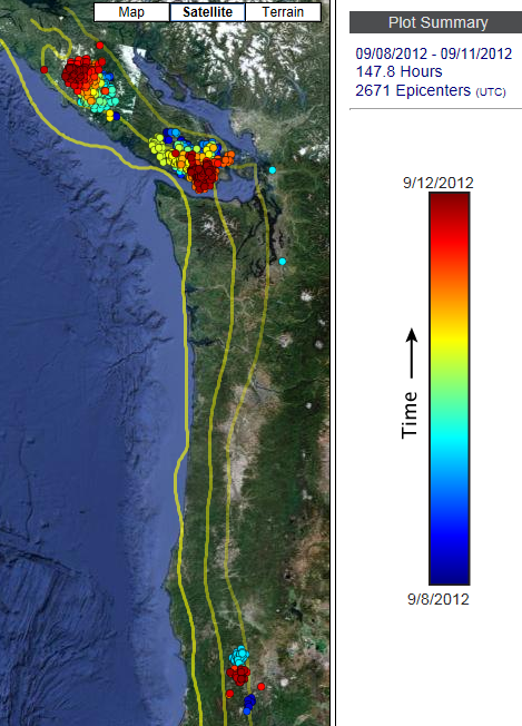
The tremor under Vancouver Island continues on with 4000+ epicenters over the past week. It seems to slowly be moving south, and possibly up-dip.
 (click to enlarge)
Source
This is the most recent update to the tremor blog found here.
 (click to enlarge)
 Source
This is the most recent update to the tremor blog found here.
Sep.1, 2012 - Probably nothing but a batch of tremor has been going on the past two days on southern Vancouver Island very close to the northern end of the normal every ~14 month ETS tremor patch. This bunch seems a bit up-dip (SW) from previous patches which is interesting but nothing more than that at this point.
reply to post by nonnez
It may be a bit shallow to be associated with the subduction zone interface, but a jolt reported by over 600 residents regardless. Hopefully it will act as a reminder to the population to have preparations in place.
Thanks for posting this quake.
Same fault, different subject.
The tremor in Canada continues.
 (click to enlarge)
Map Source
The 2012 tremor blog has some interesting observations and predictions.
Ken Creager from UW and Garry Rogers of PGC (tremor expert from north of the border) believe the current episode is very similar to 2010 and 2011 bursts, which seem to be following an every 15-month interval.
Read more at the blog link.
And another positive development is that the ETS diagnostic spectrograms are back, and have been upgraded to include stations on Vancouver Island. Thank you PNSN--I really enjoy following along at home.
It may be a bit shallow to be associated with the subduction zone interface, but a jolt reported by over 600 residents regardless. Hopefully it will act as a reminder to the population to have preparations in place.
Thanks for posting this quake.
Same fault, different subject.
The tremor in Canada continues.
 (click to enlarge)
 Map Source
The 2012 tremor blog has some interesting observations and predictions.
We have independent predictions that this tremor episode will stop within a day or two and NOT emigrate to the US from Canada.
Ken Creager from UW and Garry Rogers of PGC (tremor expert from north of the border) believe the current episode is very similar to 2010 and 2011 bursts, which seem to be following an every 15-month interval.
Read more at the blog link.
And another positive development is that the ETS diagnostic spectrograms are back, and have been upgraded to include stations on Vancouver Island. Thank you PNSN--I really enjoy following along at home.
Yes, thank you, Olivine. I have an idea that there are quite a few of us silent observers.
Ditto. Olivine, I also have been following your posts and appreciate all the work you put into displaying your information. One of these days I may
have a question or comment.
Thank you AuntB and NiteNGale2--I will continue with the updates until things quiet down.
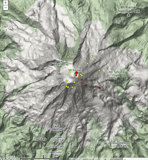
Mt. Rainier had a little fit today. Five small quakes, the largest a Mag 2.4 located 2.7 km directly below the summit.
PNSN has switched the layout and look of the their seismograms. I'm still getting used to it. Here is the link for RCM Camp Muir station for today.
I'm hoping the noisy looking squiggles at the bottom are just wind, but I only see it on this station and Observation Rock (OBSR), which is farther down the mountain on the NW flank.
Edit to add: I see the "wind" signature on station FMW, too...odd that it doesn't show on the other high altitude stations (STAR & RCS).
Iris Station UW. FMW..EHZ
You can still access the old blue seismograms from old.pnsn.org..., but I don't know for how much longer.
Yesterday shows over 40 hours of tremor, but a good bit of that was located in northern California.
edit on 9/13/2012 by Olivine because: (no
reason given)
edit on 9/13/2012 by Olivine because: add link
So much for this tremor episode stopping in a "day or two", as predicted by the pros.
The tremor and slow slip has bifurcated under Vancouver Island, with the southern half still inching its way toward the Olympic pennisula. If you check the real-time tremor page you can see this episode is continuing.
Map courtesy of PNSN
The tremor in northern California seems to persisting. I wonder if Oregon will join in?
...........
Two earthquakes in norCal just a few minutes ago---Mag 4.5 23.7 km deep and Mag 3.2 25.4 km deep, both just SW of Rio Dell. (Mendocino Triple Junction vicinity)
Here is a link to a nearby seismogram CapeTown
edit on 9/14/2012 by
Olivine because: add link
I too keep an eye on this thread daily, and the updates are greatly appreciated. Living in Vancouver, I keep wondering when the ground is going to
start moving.
Here is a Pacific Northwest mystery: where is the PNSN or USGS
listing for the event that occurred at 20:25 UTC?
(1-1/2 hours ago)
Check out these 2 links:
ANF Cascadia snapshot(past 24 hrs)
 (click to enlarge)
PNSN Spectrograms
I see an earthquake that registers from northern CA/Oregon border all the way to Olympic mountains. Please don't tell me it was another "explosion". Meteor I might buy...
ETA:
If this was a teleseism, surely it was big enough to meet the USGS Mag 4.5 minimum to rate a mention....
Found it! (well preliminarily)
LDEO Surface Wave detection page has a Mag 5.0 listed off the coast of Oregon at the right time.
When (if?) USGS lists this quake it will probably be a few tenths lower in magnitude. At least that is what I notice in most cases.
(1-1/2 hours ago)
Check out these 2 links:
ANF Cascadia snapshot(past 24 hrs)
 (click to enlarge)
 PNSN Spectrograms
I see an earthquake that registers from northern CA/Oregon border all the way to Olympic mountains. Please don't tell me it was another "explosion". Meteor I might buy...
ETA:
If this was a teleseism, surely it was big enough to meet the USGS Mag 4.5 minimum to rate a mention....
edit on 9/14/2012 by Olivine because:
(no reason given)
edit on 9/14/2012 by Olivine because: fix format
Found it! (well preliminarily)
LDEO Surface Wave detection page has a Mag 5.0 listed off the coast of Oregon at the right time.
When (if?) USGS lists this quake it will probably be a few tenths lower in magnitude. At least that is what I notice in most cases.
2012 9 14 20 24 24.0 44.25 -129.25 33.0 5.0 OFF COAST OF OREGON
edit on 9/14/2012 by Olivine because: just solving my own
mystery
new topics
-
Maestro Benedetto
Literature: 1 hours ago -
Is AI Better Than the Hollywood Elite?
Movies: 1 hours ago -
Las Vegas UFO Spotting Teen Traumatized by Demon Creature in Backyard
Aliens and UFOs: 4 hours ago -
2024 Pigeon Forge Rod Run - On the Strip (Video made for you)
Automotive Discussion: 5 hours ago -
Gaza Terrorists Attack US Humanitarian Pier During Construction
Middle East Issues: 5 hours ago -
The functionality of boldening and italics is clunky and no post char limit warning?
ATS Freshman's Forum: 7 hours ago -
Meadows, Giuliani Among 11 Indicted in Arizona in Latest 2020 Election Subversion Case
Mainstream News: 7 hours ago -
Massachusetts Drag Queen Leads Young Kids in Free Palestine Chant
Social Issues and Civil Unrest: 7 hours ago -
Weinstein's conviction overturned
Mainstream News: 9 hours ago -
Supreme Court Oral Arguments 4.25.2024 - Are PRESIDENTS IMMUNE From Later Being Prosecuted.
Above Politics: 10 hours ago
top topics
-
Krystalnacht on today's most elite Universities?
Social Issues and Civil Unrest: 10 hours ago, 9 flags -
Supreme Court Oral Arguments 4.25.2024 - Are PRESIDENTS IMMUNE From Later Being Prosecuted.
Above Politics: 10 hours ago, 8 flags -
University of Texas Instantly Shuts Down Anti Israel Protests
Education and Media: 13 hours ago, 7 flags -
Weinstein's conviction overturned
Mainstream News: 9 hours ago, 7 flags -
Gaza Terrorists Attack US Humanitarian Pier During Construction
Middle East Issues: 5 hours ago, 7 flags -
Massachusetts Drag Queen Leads Young Kids in Free Palestine Chant
Social Issues and Civil Unrest: 7 hours ago, 6 flags -
Meadows, Giuliani Among 11 Indicted in Arizona in Latest 2020 Election Subversion Case
Mainstream News: 7 hours ago, 5 flags -
Las Vegas UFO Spotting Teen Traumatized by Demon Creature in Backyard
Aliens and UFOs: 4 hours ago, 4 flags -
2024 Pigeon Forge Rod Run - On the Strip (Video made for you)
Automotive Discussion: 5 hours ago, 2 flags -
Any one suspicious of fever promotions events, major investor Goldman Sachs card only.
The Gray Area: 15 hours ago, 2 flags
active topics
-
VP's Secret Service agent brawls with other agents at Andrews
Mainstream News • 62 • : ByeByeAmericanPie -
University of Texas Instantly Shuts Down Anti Israel Protests
Education and Media • 228 • : cherokeetroy -
SETI chief says US has no evidence for alien technology. 'And we never have'
Aliens and UFOs • 72 • : yuppa -
My Poor Avocado Plant.
General Chit Chat • 77 • : JonnyC555 -
New whistleblower Jason Sands speaks on Twitter Spaces last night.
Aliens and UFOs • 61 • : Ophiuchus1 -
Is AI Better Than the Hollywood Elite?
Movies • 2 • : 5thHead -
Gaza Terrorists Attack US Humanitarian Pier During Construction
Middle East Issues • 25 • : CarlLaFong -
Mood Music Part VI
Music • 3102 • : Hellmutt -
Las Vegas UFO Spotting Teen Traumatized by Demon Creature in Backyard
Aliens and UFOs • 9 • : Ophiuchus1 -
British TV Presenter Refuses To Use Guest's Preferred Pronouns
Education and Media • 164 • : Annee