It looks like you're using an Ad Blocker.
Please white-list or disable AboveTopSecret.com in your ad-blocking tool.
Thank you.
Some features of ATS will be disabled while you continue to use an ad-blocker.

Quake Watch 2012
page: 60share:
reply to post by Jerisa
Just added a list of quakes in the area to that post.
Note to self: Must stop updating posts after people have commented!!
Just added a list of quakes in the area to that post.
Note to self: Must stop updating posts after people have commented!!
reply to post by chiefsmom
Indeed you did and thank you. I saw your link. It was just that the etch-a-sketch picture tickled me. I did star that link to here for you.
Indeed you did and thank you. I saw your link. It was just that the etch-a-sketch picture tickled me. I did star that link to here for you.
earthquake2012-02-28 15:24:17.0
42min ago 49.11 N 156.33 E 15 mb 5.2 KURIL ISLANDS 2012-02-28 15:57
earthquake2012-02-28 15:07:35.0
58min ago 28.25 N 139.34 E 502 mb 5.5 BONIN ISLANDS, JAPAN REGION 2012-02-28 15:46
earthquake2012-02-28 14:30:11.2
1hr 36min ago 43.34 N 145.71 E 102 mb 5.0 HOKKAIDO, JAPAN REGION
EMSC
Hmmmm...all along the same fault line?
Rainbows
Jane
Asia - Russia, people. It might be nothing, but it could be something, so no attitude, please.
Past 24 hours for those not watching:
4.5 2012/02/28 17:00:05 54.566 168.569 35.6 KOMANDORSKIYE OSTROVA, RUSSIA
4.6 2012/02/28 16:23:01 31.741 131.670 42.2 KYUSHU, JAPAN
5.0 2012/02/28 15:24:21 49.141 156.117 40.0 KURIL ISLANDS
5.4 2012/02/28 15:07:35 28.200 139.391 503.3 BONIN ISLANDS, JAPAN REGION
4.7 2012/02/28 14:30:10 43.211 145.721 98.6 HOKKAIDO, JAPAN REGION
5.1 2012/02/28 05:33:32 49.387 156.063 37.2 KURIL ISLANDS
5.0 2012/02/28 05:20:49 36.410 141.036 12.3 NEAR THE EAST COAST OF HONSHU, JAPAN
4.9 2012/02/28 04:51:04 36.295 142.029 16.0 OFF THE EAST COAST OF HONSHU, JAPAN
4.9 2012/02/28 04:40:30 36.314 142.207 18.1 OFF THE EAST COAST OF HONSHU, JAPAN
5.6 2012/02/27 19:31:49 25.575 127.159 18.6 RYUKYU ISLANDS, JAPAN
4.7 2012/02/27 16:30:36 38.599 141.713 70.6 NEAR THE EAST COAST OF HONSHU, JAPAN
5.0 2012/02/27 16:29:25 25.494 127.273 41.4 RYUKYU ISLANDS, JAPAN
A swarm near Fiji, too, but yeah, I'm more focused on Asia - Russia, keeping a close eye on the scene. Small-med size quakes will hopefully even it all out, but you never know.
March, be quiet- you.
Magnitude mb 4.6
Region IRAN-IRAQ BORDER REGION
Date time 2012-02-28 23:18:55.0 UTC
Location 32.60 N ; 47.04 E
Depth 30 km
Distances 84 km NW Al-'amarah (pop 323,302 ; local time 02:18:55.4 2012-02-29)
23 km SW Dehloran (pop 46,002 ; local time 02:18:55.4 2012-02-29)
EMSC
www.ustream.tv...
A big uptick in the past 10-20 minutes. The thing keeps going wild with alerts. They're saying that Keio Line railway has been delayed and that Yamanashi keeps shaking.
"Good morning! The Yamanashi M waveform and the earthquake more than 4 are on the rise, beware today & surveillance."
"Near the Mount Fuji with the earthquake I'm afraid..."
Translating the best I can with the little I know of Japanese and a translator at hand.
They seem concerned of Yamanashi still, and keep mentioning to practice "blank" exercises.
To update since...
5.4 2012/02/28 22:52:38 37.187 144.113 10.2 OFF THE EAST COAST OF HONSHU, JAPAN
4.8 2012/02/28 18:05:22 49.322 156.142 46.2 KURIL ISLANDS
edit on 28/2/12 by murkraz because: (no reason given)
Magnitude mb 5.1
Region KEPULAUAN BARAT DAYA, INDONESIA
Date time 2012-02-28 23:52:34.0 UTC
Location 7.54 S ; 128.23 E
Depth 142 km
Distances 313 km E Dili (pop 159,721 ; local time 07:52:34.5 2012-02-29)
169 km NE Los palos (pop 17,042 ; local time 07:52:34.5 2012-02-29)
EMSC
Originally posted by Hellas
reply to post by murkraz
Are those graphs, seismographs in real time? Cause there going wild
They are real-time.
It is a make up of several agencies working together as far as I can tell. I honestly don't know what I'm entirely looking at aside from the left graph. Not sure what the right refers to.
I know a normal trend cause I've watched it a dozen times or so, seems more elevated as of a half hour ago, they seem to be hasty with the chat updates, too.
It was originally posted here, can't recall by who but they might know more than I do.
edit on 28/2/12 by murkraz because: (no reason
given)
reply to post by murkraz
Kuril Islands
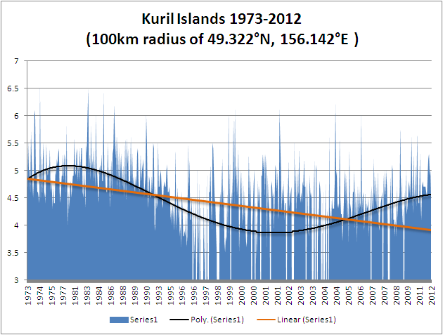
Interesting how statistics can lie. The linear trend is down over the period but the polynomial shows a different picture.
Either here or Alaska are my choice for the next mega-quake.I have no idea why, just a feeling. We will have none of that
unscientific stuff here thank you PM.
Kuril Islands
Interesting how statistics can lie. The linear trend is down over the period but the polynomial shows a different picture.
Either here or Alaska are my choice for the next mega-quake.
Magnitude mb 5.1
Region KURIL ISLANDS
Date time 2012-02-29 01:22:54.3 UTC
Location 49.37 N ; 156.10 E
Depth 60 km
Distances 443 km SW Petropavlovsk-kamchatskiy (pop 187,282 ; local time 13:22:54.3 2012-02-29)
447 km SW Mokhovaya, petropavlovsk-kamch (pop 22,815 ; local time 13:22:54.3 2012-02-29)
146 km S Severo-kurilsk (pop 2,286 ; local time 12:22:54.3 2012-02-29)
EMSC
Magnitude
4.2
Date-Time
Wednesday, February 29, 2012 at 01:27:28 UTC
Tuesday, February 28, 2012 at 05:27:28 PM at epicenter
Location
32.107°N, 115.301°W
Depth
20.1 km (12.5 miles) (poorly constrained)
Region
BAJA CALIFORNIA, MEXICO
Distances
27 km (17 miles) SW (221°) from Guadalupe Victoria, Baja California, Mexico
63 km (39 miles) SSE (165°) from Mexicali, Baja California, Mexico
63 km (39 miles) SW (231°) from San Luis Río Colorado, Sonora, Mexico
168 km (104 miles) ESE (106°) from Tijuana, Baja California, Mexico
Location Uncertainty
horizontal +/- 1.6 km (1.0 miles); depth +/- 35.3 km (21.9 miles)
Parameters
Nph= 29, Dmin=60 km, Rmss=0.43 sec, Gp=256°,
M-type=regional moment magnitude (Mw), Version=2
Source
California Integrated Seismic Net:
USGS Caltech CGS UCB UCSD UNR
Event ID
ci15115905
USGS
edit on 28-2-2012 by Hellas because: (no reason
given)
reply to post by PuterMan
Interesting graph
Might get a different poly line if you went back a bit to the 1960's
Kurile Islands
1963 - 8.5
1969 - 8.1
I seen them on Fig. 3.7 page 13 Chapter 3 of the Geofon Manual
Interesting graph
Might get a different poly line if you went back a bit to the 1960's
Kurile Islands
1963 - 8.5
1969 - 8.1
I seen them on Fig. 3.7 page 13 Chapter 3 of the Geofon Manual
3.7 2012/02/28 21:00:33 41.141N 123.795W 30.6 9 KM ( 6 MI) SW OF WEITCHPEC, CA
4.2 2012/02/28 17:27:28 32.107N 115.301W 20.1 27 KM (17 MI) SW OF GUADALUPE VICTORIA, BAJA CALIFORNIA, MEXICO
3.5 2012/02/28 12:15:32 33.896N 119.424W 12.1 35 KM (21 MI) SSW OF CHANNEL ISLANDS BEACH, CA
3.0 2012/02/28 11:17:34 40.273N 124.321W 20.0 7 KM ( 4 MI) SSW OF PETROLIA, CA
earthquake.usgs.gov...
reply to post by muzzy
Ya, I was in a hurry and the USGS circular search. like so many of their catalogues, only starts from the early 1970s. I hate starting there because it was near the lowest ebb as the tide of quakes turned and started coming back in again to reach full tide last year in Japan. Now the tide turns, and starts to flow out again to a low tide in 2035 or thereabouts before building to a new crescendo around 2060.
Well it's verbally picturesque even if you think it is rubbish (which I happen to think it is not). What really annoys the hell out me is that I won't be around then to see if I was right! Where is that elixir of immortality, I want some.
reply to post by Hellas
Iran is quaking again I see. Hmmm? I hope they dont have a big one and think its the US.
Iran is quaking again I see. Hmmm? I hope they dont have a big one and think its the US.
Magnitude
5.7
Date-Time
Wednesday, February 29, 2012 at 14:32:45 UTC
Wednesday, February 29, 2012 at 11:32:45 PM at epicenter
Location
35.218°N, 141.006°E
Depth
9.8 km (6.1 miles)
Region
NEAR THE EAST COAST OF HONSHU, JAPAN
Distances
124 km (77 miles) ESE (113°) from TOKYO, Japan
136 km (85 miles) SSE (160°) from Mito, Honshu, Japan
206 km (128 miles) S (177°) from Iwaki, Honshu, Japan
Location Uncertainty
horizontal +/- 12.4 km (7.7 miles); depth +/- 3.9 km (2.4 miles)
Parameters
NST=413, Nph=418, Dmin=258.3 km, Rmss=0.72 sec, Gp= 32°,
M-type=body wave magnitude (Mb), Version=7
Source
Magnitude: USGS NEIC (WDCS-D)
Location: USGS NEIC (WDCS-D)
Event ID
usb00088dt
USGS
Originally posted by MamaJ
reply to post by Hellas
Iran is quaking again I see. Hmmm? I hope they dont have a big one and think its the US.
No one gives that much credibility to the US
new topics
-
President BIDEN's FBI Raided Donald Trump's Florida Home for OBAMA-NORTH KOREA Documents.
Political Conspiracies: 2 hours ago -
Maestro Benedetto
Literature: 3 hours ago -
Is AI Better Than the Hollywood Elite?
Movies: 3 hours ago -
Las Vegas UFO Spotting Teen Traumatized by Demon Creature in Backyard
Aliens and UFOs: 7 hours ago -
2024 Pigeon Forge Rod Run - On the Strip (Video made for you)
Automotive Discussion: 8 hours ago -
Gaza Terrorists Attack US Humanitarian Pier During Construction
Middle East Issues: 8 hours ago -
The functionality of boldening and italics is clunky and no post char limit warning?
ATS Freshman's Forum: 9 hours ago -
Meadows, Giuliani Among 11 Indicted in Arizona in Latest 2020 Election Subversion Case
Mainstream News: 10 hours ago -
Massachusetts Drag Queen Leads Young Kids in Free Palestine Chant
Social Issues and Civil Unrest: 10 hours ago -
Weinstein's conviction overturned
Mainstream News: 11 hours ago
top topics
-
President BIDEN's FBI Raided Donald Trump's Florida Home for OBAMA-NORTH KOREA Documents.
Political Conspiracies: 2 hours ago, 20 flags -
Krystalnacht on today's most elite Universities?
Social Issues and Civil Unrest: 13 hours ago, 9 flags -
University of Texas Instantly Shuts Down Anti Israel Protests
Education and Media: 16 hours ago, 8 flags -
Weinstein's conviction overturned
Mainstream News: 11 hours ago, 8 flags -
Supreme Court Oral Arguments 4.25.2024 - Are PRESIDENTS IMMUNE From Later Being Prosecuted.
Above Politics: 13 hours ago, 8 flags -
Massachusetts Drag Queen Leads Young Kids in Free Palestine Chant
Social Issues and Civil Unrest: 10 hours ago, 7 flags -
Gaza Terrorists Attack US Humanitarian Pier During Construction
Middle East Issues: 8 hours ago, 7 flags -
Meadows, Giuliani Among 11 Indicted in Arizona in Latest 2020 Election Subversion Case
Mainstream News: 10 hours ago, 5 flags -
Las Vegas UFO Spotting Teen Traumatized by Demon Creature in Backyard
Aliens and UFOs: 7 hours ago, 4 flags -
2024 Pigeon Forge Rod Run - On the Strip (Video made for you)
Automotive Discussion: 8 hours ago, 3 flags
active topics
-
Supreme Court Oral Arguments 4.25.2024 - Are PRESIDENTS IMMUNE From Later Being Prosecuted.
Above Politics • 84 • : Daughter2v2 -
Is AI Better Than the Hollywood Elite?
Movies • 12 • : rickymouse -
British TV Presenter Refuses To Use Guest's Preferred Pronouns
Education and Media • 170 • : Annee -
Massachusetts Drag Queen Leads Young Kids in Free Palestine Chant
Social Issues and Civil Unrest • 14 • : ToneD -
President BIDEN's FBI Raided Donald Trump's Florida Home for OBAMA-NORTH KOREA Documents.
Political Conspiracies • 6 • : pianopraze -
Sol Et Luna - TIME2024
Short Stories • 10 • : BrotherKinsMan -
University of Texas Instantly Shuts Down Anti Israel Protests
Education and Media • 263 • : cherokeetroy -
Gaza Terrorists Attack US Humanitarian Pier During Construction
Middle East Issues • 26 • : nugget1 -
Manly P. Hall says Freemasonry is a religion?
Secret Societies • 22 • : Therealbeverage -
One Flame Throwing Robot Dog for Christmas Please!
Weaponry • 11 • : Therealbeverage