It looks like you're using an Ad Blocker.
Please white-list or disable AboveTopSecret.com in your ad-blocking tool.
Thank you.
Some features of ATS will be disabled while you continue to use an ad-blocker.

Quake Watch 2012
page: 62share:
reply to post by PuterMan
Very interesting thought,as this earthquake is very close to....
Kiss ,Cheer and Star are for you PuterMan
scold
Me small.
reply to post by diamondsmith
Well star for you as well. Mm, so maybe this is a precursor to -W1LLsbrass band competition pole shift?
Well star for you as well. Mm, so maybe this is a precursor to -W1LLs
reply to post by PuterMan
Ty Puterman , I was looking at the page with the red,orange and yellow circles...lol....
Ty Puterman , I was looking at the page with the red,orange and yellow circles...lol....
Earthquake Details
This event has been reviewed by a seismologist.
Magnitude
5.6 (Preliminary magnitude — update expected within 15 minutes)
Date-Time
Friday, March 02, 2012 at 16:48:25 UTC
Friday, March 02, 2012 at 06:48:25 AM at epicenter
Location
51.274°N, 178.181°E
Depth
195 km (121.2 miles) set by location program
Region
RAT ISLANDS, ALEUTIAN ISLANDS, ALASKA
Distances
384 km (238 miles) ESE (115°) from Attu Station, AK
1342 km (834 miles) E (90°) from Petropavlovsk-Kamchatskiy, Russia
3498 km (2174 miles) NE (48°) from TOKYO, Japan
Location Uncertainty
Error estimate not available
Parameters
NST= 25, Nph= 25, Dmin=219.7 km, Rmss=0.82 sec, Gp=223°,
M-type=body wave magnitude (Mb), Version=1
Source
West Coast and Alaska Tsunami Warning Center/NOAA/NWS
Event ID
at00m09o0p
USGS
So there was a 5.6 in alaska followed by a 5.1 in very similar regions 6 seconds apart?! wow!
link to 5.1 earthquake.usgs.gov...
link to 5.1 earthquake.usgs.gov...
edit on 2-3-2012 by phoenixlights321 because: (no reason
given)
What's all this about!
2012/03/02 14:59:01.3 59.482 -1.743 9 3.2 3 FAIR ISLE,SHETLAND FELT FAIR ISLE...
2012/02/29 14:55:29.2 56.233 -4.841 1 2.4 3 ARROCHAR,ARYLL/BUTE FELT ARROCHAR...
2012/02/29 09:32:06.7 55.766 -6.351 10 1.2 3 ISLAY,ARGYLL/BUTE FELT ISLAY
2012/02/29 09:25:08.3 55.783 -6.352 9 2.1 3 ISLAY,ARGYLL/BUTE FELT ISLAY
2012/02/29 09:14:26.0 55.778 -6.342 12 2.8 3 ISLAY,ARGYLL/BUTE FELT ISLAY
2012/02/29 07:50:55.3 55.782 -6.344 9 0.9 2 ISLAY,ARGYLL/BUTE FELT ISLAY
2012/02/29 07:04:13.3 55.767 -6.339 10 1.0 2 ISLAY,ARGYLL/BUTE FELT ISLAY
2012/02/29 03:00:30.3 56.653 -6.384 4 1.2 MULL,ARGYLL/BUTE 10KM NW OF CALGARY
2012/02/27 08:20:47.3 55.776 -6.301 12 1.6 3 ISLAY,ARGYLL/BUTE FELT ISLAY
2012/02/26 22:31:16.0 54.650 -0.839 5 2.9 2 LOFTUS,CLEVELAND OFFSHORE LOCATION
2012/02/22 08:40:13.4 53.332 2.530 11 2.7 SOUTHERN NORTH SEA 90KM ENE OF CROMER
2012/02/20 07:18:20.0 55.750 -6.317 9 1.4 2 ISLAY,ARGYLL/BUTE FELT ISLAY
2012/02/20 05:35:48.9 55.780 -6.349 12 2.6 3 ISLAY,ARGYLL/BUTE FELT ISLAY
www.earthquakes.bgs.ac.uk...
OK...this needs a closer look...*goes off in search of the experts here!*
Rainbows
Jane
reply to post by angelchemuel
There's some action going on in South East Iceland. Could that be what it is?
5
There's some action going on in South East Iceland. Could that be what it is?
5
Originally posted by angelchemuel
What's all this about!
2012/03/02 14:59:01.3 59.482 -1.743 9 3.2 3 FAIR ISLE,SHETLAND FELT FAIR ISLE...
2012/02/29 14:55:29.2 56.233 -4.841 1 2.4 3 ARROCHAR,ARYLL/BUTE FELT ARROCHAR...
2012/02/29 09:32:06.7 55.766 -6.351 10 1.2 3 ISLAY,ARGYLL/BUTE FELT ISLAY
2012/02/29 09:25:08.3 55.783 -6.352 9 2.1 3 ISLAY,ARGYLL/BUTE FELT ISLAY
2012/02/29 09:14:26.0 55.778 -6.342 12 2.8 3 ISLAY,ARGYLL/BUTE FELT ISLAY
2012/02/29 07:50:55.3 55.782 -6.344 9 0.9 2 ISLAY,ARGYLL/BUTE FELT ISLAY
2012/02/29 07:04:13.3 55.767 -6.339 10 1.0 2 ISLAY,ARGYLL/BUTE FELT ISLAY
2012/02/29 03:00:30.3 56.653 -6.384 4 1.2 MULL,ARGYLL/BUTE 10KM NW OF CALGARY
2012/02/27 08:20:47.3 55.776 -6.301 12 1.6 3 ISLAY,ARGYLL/BUTE FELT ISLAY
2012/02/26 22:31:16.0 54.650 -0.839 5 2.9 2 LOFTUS,CLEVELAND OFFSHORE LOCATION
2012/02/22 08:40:13.4 53.332 2.530 11 2.7 SOUTHERN NORTH SEA 90KM ENE OF CROMER
2012/02/20 07:18:20.0 55.750 -6.317 9 1.4 2 ISLAY,ARGYLL/BUTE FELT ISLAY
2012/02/20 05:35:48.9 55.780 -6.349 12 2.6 3 ISLAY,ARGYLL/BUTE FELT ISLAY
www.earthquakes.bgs.ac.uk...
OK...this needs a closer look...*goes off in search of the experts here!*
Rainbows
Jane
Your link isn't working...
reply to post by Jerisa
i Ionly posted this a short while ago...certainly not the 4 it says I have so here is the link all fresh!
www.earthquakes.bgs.ac.uk...
Rainbows
Jane
www.earthquakes.bgs.ac.uk...
Rainbows
Jane
Magnitude mb 5.1
Region HALMAHERA, INDONESIA
Date time 2012-03-02 17:52:29.6 UTC
Location 1.86 N ; 127.08 E
Depth 61 km
Distances 123 km NW Ternate (pop 101,731 ; local time 02:52:29.6 2012-03-03)
135 km NW Tidore (pop 46,149 ; local time 02:52:29.6 2012-03-03)
EMSC
reply to post by angelchemuel
Did you find one Miss Rainbows?
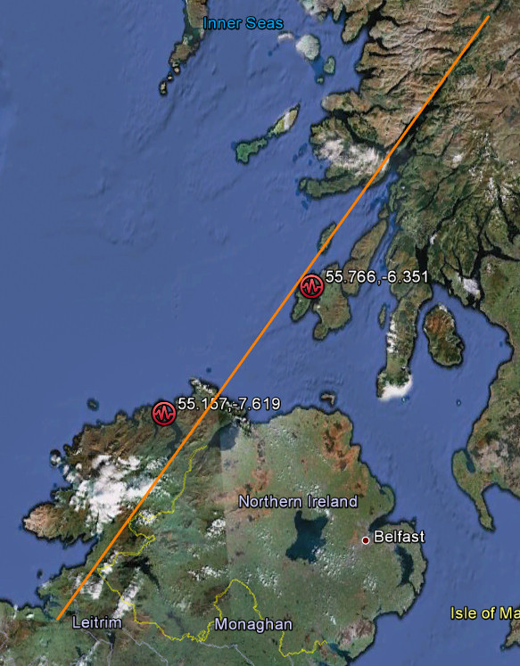
They seem a bit long in the tooth now. Unfortunately there does not seem to be any way to find out if this has happened before in the area. I'm wondering if the Great Glen and it's extension into Ireland moved a little bearing in mind the Buncrana quake.
Did you find one Miss Rainbows?
They seem a bit long in the tooth now. Unfortunately there does not seem to be any way to find out if this has happened before in the area. I'm wondering if the Great Glen and it's extension into Ireland moved a little bearing in mind the Buncrana quake.
reply to post by PuterMan
Thanks for that Mr Puters! Really curious when you join the 'dots' like that.
So does the Great Glenn join the Highland Boundary fault line? And does this qualify as the start of a little swarm?
Rainbows
Jane
Thanks for that Mr Puters! Really curious when you join the 'dots' like that.
So does the Great Glenn join the Highland Boundary fault line? And does this qualify as the start of a little swarm?
Rainbows
Jane
reply to post by angelchemuel
I don't believe the two join, although I can't be certain. I know that the Great Glen Fault runs down from Sneckie to Fort William and then out through Donegal and Clew Bay (not 25 miles from me). The fascinating thing is that although now divided by the Mid Atlantic Ridge, this fault continued on through America. There are surprising similarities between plants on the West Coast of Ireland and Newfoundland Coast.
The Highland Boundary fault is further down and marks the divide below Perth where the Sassenachs begin (Lowlanders - later applied to the English)
Well I guess it already is a little swarm as there are probably smaller quakes popping off that are not getting recorded.
So does the Great Glenn join the Highland Boundary fault line? And does this qualify as the start of a little swarm?
I don't believe the two join, although I can't be certain. I know that the Great Glen Fault runs down from Sneckie to Fort William and then out through Donegal and Clew Bay (not 25 miles from me). The fascinating thing is that although now divided by the Mid Atlantic Ridge, this fault continued on through America. There are surprising similarities between plants on the West Coast of Ireland and Newfoundland Coast.
The Highland Boundary fault is further down and marks the divide below Perth where the Sassenachs begin (Lowlanders - later applied to the English)
Well I guess it already is a little swarm as there are probably smaller quakes popping off that are not getting recorded.
edit on 2/3/2012 by PuterMan because: (no reason given)
Strong frictional heating along the Hayward fault is causing convergence of the flow of air; sfports.wr.usgs.gov...
twitter.com...#!/quakeprediction
sfports.wr.usgs.gov...
Well, I have never seen the wind act like that before. Altho it may be usual, I dunno!
reply to post by PuterMan
Yay! I found a swarm in the UK!
That is amazing info about the Great Glenn...thank you soooo much Puters as always.
So worth keeping an eye on then...especially as you think it's the Glenn has moved....Loch Ness next!
Would you mind me copying your post on the thread I started on this?
Rainbows
Jane
edit on 2-3-2012 by angelchemuel because: (no reason given)
Never say never.
source(earthquake.usgs.gov...
Magnitude 4.5
Date-Time Saturday, March 03, 2012 at 08:10:57 UTC Saturday, March 03, 2012 at 08:10:57 PM at epicenter Time of Earthquake in other Time Zones
Location 65.656°N, 173.960°W
Depth 9.7 km (6.0 miles)
Region CHUKOTKA, RUSSIA
Distances 145 km (90 miles) NNW of Provideniya, Chukotka, Russia 231 km (143 miles) W of Little Diomede Island, Alaska 234 km (145 miles) NNW of Gambell, Alaska 6277 km (3900 miles) NNE of MOSCOW, Russia
Location Uncertainty horizontal +/- 19.1 km (11.9 miles); depth +/- 4.1 km (2.5 miles)
Parameters NST= 83, Nph= 86, Dmin=236 km, Rmss=0.96 sec, Gp= 76°, M-type=body wave magnitude (Mb), Version=5
Earthquake Details
This event has been reviewed by a seismologist.
Magnitude 6.9 (Preliminary magnitude — update expected within 15 minutes)
Date-Time
Saturday, March 03, 2012 at 12:19:57 UTC
Saturday, March 03, 2012 at 11:19:57 PM at epicenter
Location 22.300°S, 170.200°E
Depth 31 km (19.3 miles) set by location program
Region SOUTHEAST OF THE LOYALTY ISLANDS
Distances
254 km (158 miles) ESE (110°) from Tadine, Loyalty Islands, New Caledonia
323 km (200 miles) SSE (163°) from Isangel, Vanuatu
386 km (240 miles) E (91°) from NOUMEA, New Caledonia
1678 km (1043 miles) NNW (344°) from Auckland, New Zealand
Location Uncertainty Error estimate not available
Parameters NST= 25, Nph= 25, Dmin=352.2 km, Rmss=1.47 sec, Gp= 79°,
M-type="moment" magnitude from initial P wave (tsuboi method) (Mi/Mwp), Version=1
Source
West Coast and Alaska Tsunami Warning Center/NOAA/NWS
Event ID at00m0b698
Source: USGS
EMSC data now in
Magnitude mb 6.2
Region SOUTHEAST OF LOYALTY ISLANDS
Date time 2012-03-03 12:19:58.9 UTC
Location 22.07 S ; 170.39 E
Depth 40 km
Distances 947 km SW Suva (pop 199,455 ; local time 00:19:58.9 2012-03-04)
350 km E Wé (pop 10,375 ; local time 23:19:58.9 2012-03-03)
265 km E Tadine (pop 7,492 ; local time 23:19:58.9 2012-03-03)
Global view
Source parameters not yet reviewed by a seismologist
Sourec: EMSC
That is quite a difference even though one is mb and the other Mw. There may be some 'adjustments' forthcoming.
USGS have now given it a new code. Expect technical data very soon. (Both links should work.)
EMSC have now reclassified it in Mw as a 6.9 so until the tensor solutions come out that is it for the present.
NO TSUNAMI
000
WEHW42 PHEB 031226
TIBHWX
HIZ001>003-005>009-012>014-016>021-023>026-031426-
TSUNAMI INFORMATION STATEMENT NUMBER 1
NWS PACIFIC TSUNAMI WARNING CENTER EWA BEACH HI
226 AM HST SAT MAR 03 2012
TO - CIVIL DEFENSE IN THE STATE OF HAWAII
SUBJECT - TSUNAMI INFORMATION STATEMENT
THIS STATEMENT IS FOR INFORMATION ONLY. NO ACTION REQUIRED.
AN EARTHQUAKE HAS OCCURRED WITH THESE PRELIMINARY PARAMETERS
ORIGIN TIME - 0220 AM HST 03 MAR 2012
COORDINATES - 22.3 SOUTH 170.2 EAST
LOCATION - SOUTHEAST OF LOYALTY ISLANDS
MAGNITUDE - 6.9 MOMENT
EVALUATION
BASED ON ALL AVAILABLE DATA A DESTRUCTIVE PACIFIC-WIDE TSUNAMI IS
NOT EXPECTED AND THERE IS NO TSUNAMI THREAT TO HAWAII. REPEAT. A
DESTRUCTIVE PACIFIC-WIDE TSUNAMI IS NOT EXPECTED AND THERE IS NO
TSUNAMI THREAT TO HAWAII.
THIS WILL BE THE ONLY STATEMENT ISSUED FOR THIS EVENT UNLESS
ADDITIONAL DATA ARE RECEIVED.
$$
edit on 3/3/2012 by PuterMan because: (no reason given)
Purely for my own personal satisfaction I would find it very useful if members creating earthquake related threads would consider posting a link on
Quake Watch.
Mainly because I don't have time to look at the lists of new threads (too bone idle?) this would be a useful thing and as this is Quake Watch it would be fitting that the topics are pointed out here.
Point in question. I had no idea that Miss Rainbows had created a thread until she mentioned it.
I don't think there is any T&C problem with pointing to your new thread (I am sure the mods will say if I am wrong) and I do not consider it touting for flags and stars if your wording is appropriate.
EG an acceptable format: "I am very concerned about the possible swarm of earthquake in the Hebrides and have started a new thread to discuss this in more depth."
Not acceptable: "I started a thread about the swarm in the Hebrides. Please come and flag it so it gets attention."
@Miss Rainbows:
Done that for you.
Mainly because I don't have time to look at the lists of new threads (too bone idle?) this would be a useful thing and as this is Quake Watch it would be fitting that the topics are pointed out here.
Point in question. I had no idea that Miss Rainbows had created a thread until she mentioned it.
I don't think there is any T&C problem with pointing to your new thread (I am sure the mods will say if I am wrong) and I do not consider it touting for flags and stars if your wording is appropriate.
EG an acceptable format: "I am very concerned about the possible swarm of earthquake in the Hebrides and have started a new thread to discuss this in more depth."
Not acceptable: "I started a thread about the swarm in the Hebrides. Please come and flag it so it gets attention."
@Miss Rainbows:
Would you mind me copying your post on the thread I started on this?
Done that for you.
edit on 3/3/2012 by PuterMan because: (no reason given)
The phase data is now available for the Vanuatu (Loyalty Islands is the FE region 14 Vanuatu) quake.
Phase data page
The average of the EMSC mb data is just over 6.4, bearing in mind they first came in at 6.2 mb.
14:11 Centroid tensor data in: Mw 6.6
earthquake.usgs.gov...
14:22
This earthquake is now officially Mw 6.6
mb = 6.6 ( 91) ML = 5.9 ( 2) mblg = 5.4 ( 1) md = 0.0 ( 0) MS = 0.0 ( 0)
Phase data page
The average of the EMSC mb data is just over 6.4, bearing in mind they first came in at 6.2 mb.
14:11 Centroid tensor data in: Mw 6.6
earthquake.usgs.gov...
14:22
This earthquake is now officially Mw 6.6
edit on 3/3/2012 by PuterMan because: (no reason given)
new topics
-
I hate dreaming
Rant: 1 minutes ago -
Is the origin for the Eye of Horus the pineal gland?
General Conspiracies: 1 hours ago -
Man sets himself on fire outside Donald Trump trial
Mainstream News: 1 hours ago -
Biden says little kids flip him the bird all the time.
2024 Elections: 2 hours ago -
The Democrats Take Control the House - Look what happened while you were sleeping
US Political Madness: 2 hours ago -
Sheetz facing racial discrimination lawsuit for considering criminal history in hiring
Social Issues and Civil Unrest: 2 hours ago -
In an Historic First, In N Out Burger Permanently Closes a Location
Mainstream News: 4 hours ago -
MH370 Again....
Disaster Conspiracies: 5 hours ago -
Are you ready for the return of Jesus Christ? Have you been cleansed by His blood?
Religion, Faith, And Theology: 7 hours ago -
Chronological time line of open source information
History: 8 hours ago
top topics
-
In an Historic First, In N Out Burger Permanently Closes a Location
Mainstream News: 4 hours ago, 14 flags -
The Democrats Take Control the House - Look what happened while you were sleeping
US Political Madness: 2 hours ago, 9 flags -
Thousands Of Young Ukrainian Men Trying To Flee The Country To Avoid Conscription And The War
Other Current Events: 15 hours ago, 8 flags -
A man of the people
Medical Issues & Conspiracies: 10 hours ago, 8 flags -
Biden says little kids flip him the bird all the time.
2024 Elections: 2 hours ago, 6 flags -
Man sets himself on fire outside Donald Trump trial
Mainstream News: 1 hours ago, 5 flags -
4 plans of US elites to defeat Russia
New World Order: 11 hours ago, 4 flags -
Are you ready for the return of Jesus Christ? Have you been cleansed by His blood?
Religion, Faith, And Theology: 7 hours ago, 3 flags -
Is the origin for the Eye of Horus the pineal gland?
General Conspiracies: 1 hours ago, 3 flags -
Sheetz facing racial discrimination lawsuit for considering criminal history in hiring
Social Issues and Civil Unrest: 2 hours ago, 3 flags
active topics
-
Is the origin for the Eye of Horus the pineal gland?
General Conspiracies • 3 • : purplemer -
I hate dreaming
Rant • 0 • : FlyersFan -
MH370 Again....
Disaster Conspiracies • 8 • : Lazy88 -
Do we live in a simulation similar to The Matrix 1999?
ATS Skunk Works • 27 • : purplemer -
Thousands Of Young Ukrainian Men Trying To Flee The Country To Avoid Conscription And The War
Other Current Events • 27 • : Xtrozero -
12 jurors selected in Trump criminal trial
US Political Madness • 86 • : ImagoDei -
911 emergency lines are DOWN across multiple states
Breaking Alternative News • 8 • : nugget1 -
Marjorie Taylor Greene Files Motion to Vacate Speaker Mike Johnson
US Political Madness • 64 • : interupt42 -
The Democrats Take Control the House - Look what happened while you were sleeping
US Political Madness • 20 • : CriticalStinker -
Man sets himself on fire outside Donald Trump trial
Mainstream News • 17 • : FlyersFan