It looks like you're using an Ad Blocker.
Please white-list or disable AboveTopSecret.com in your ad-blocking tool.
Thank you.
Some features of ATS will be disabled while you continue to use an ad-blocker.

Quake Watch 2012
page: 55share:
reply to post by muzzy
Ha ha, that is because you are not dealing with energy as much as I am. I immediately thought, oh round about 9.2 then.
That is actually 2 x stronger but 1.6 times bigger. A mag 9.3 is 2x bigger and 2.8 times stronger. Bigger refers to the signal amplitude, stronger refers to the energy released.
It is, however, as you say very misleading to those not in the know Mag 18!!!!!! OMG !!!
BTW, at round about a Mag 12 the surface area and length of rupture girdles the entire plant so I doubt if there has ever been one as large as that.
This day 120 years ago there was a 7.8 in California, and 31 years ago a 6.8 in Greece (I remember hearing about that one but not the California one - not quite)
earthquake.usgs.gov...
edit on 24/2/2012 by PuterMan because: (no reason given)
reply to post by SharnaPax
Thanks for the input. That would certainly explain some of the smaller noise for sure. (the stuff around 0600 CST)
The other was certainly trains, and the fact that it is till there today exactly the same pretty much confirms it.
As an aside this 2010 report is a look at transportation in Arkansas.
Thanks for the input. That would certainly explain some of the smaller noise for sure. (the stuff around 0600 CST)
The other was certainly trains, and the fact that it is till there today exactly the same pretty much confirms it.
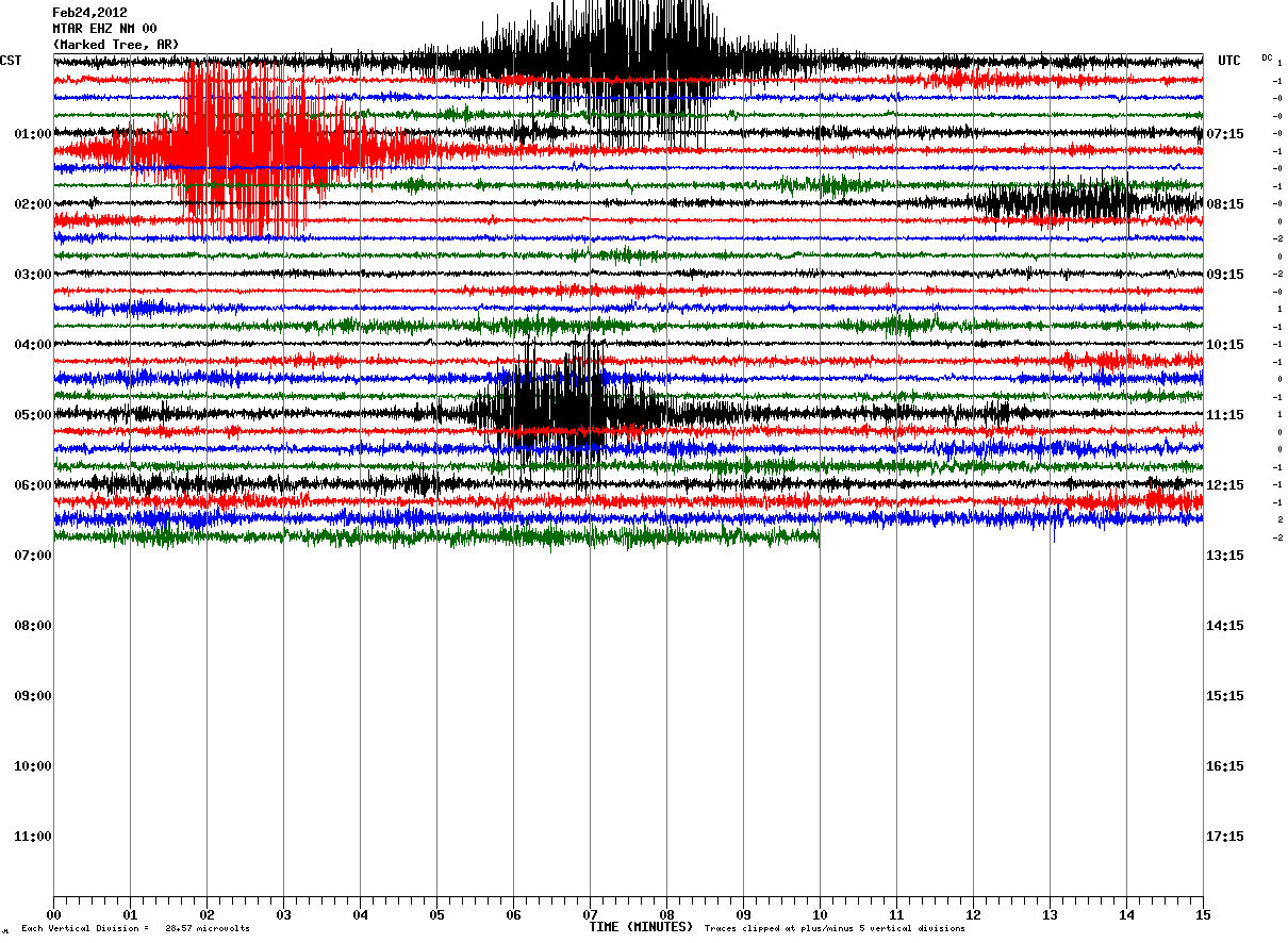
As an aside this 2010 report is a look at transportation in Arkansas.
Roll up folks! Your to keep absolutely free of charge when you subscribe to Quake Watch 2011, 2012 and subsequent years - the
Carefully crafted for your especial enjoyment this fabulous chart show the values for bigger than, and stronger than, for earthquakes from 0.1 to 9.5 by comparison to Magnitude 0. This wonderful heirloom gift will be treasured by your family down the generations and should give you minutes of enjoyment and entertainment.
Yours to keep even if you cancel your subscription to Quake Watch.
See instructions at the end.
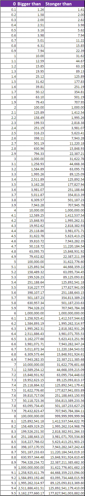
For a single calculation you can use this USGS calculator
Forgot to say you can of course use this to find the values for any pair of earthquakes. Say you wanted to know the difference between a Mag 8.1 and a mag 7.5
The difference is 0.6 so look up 0.6 and you get 3.98 x bigger and 7.94 x stronger so you see it can be useful after all.
Mag 6.9 and Mag 7.8? 0.9 = 7.94 x bigger and 22.39 x stronger.
Enjoy
Bigger than, Stronger than chart
Carefully crafted for your especial enjoyment this fabulous chart show the values for bigger than, and stronger than, for earthquakes from 0.1 to 9.5 by comparison to Magnitude 0. This wonderful heirloom gift will be treasured by your family down the generations and should give you minutes of enjoyment and entertainment.
Yours to keep even if you cancel your subscription to Quake Watch.
See instructions at the end.
For a single calculation you can use this USGS calculator
Forgot to say you can of course use this to find the values for any pair of earthquakes. Say you wanted to know the difference between a Mag 8.1 and a mag 7.5
The difference is 0.6 so look up 0.6 and you get 3.98 x bigger and 7.94 x stronger so you see it can be useful after all.
Mag 6.9 and Mag 7.8? 0.9 = 7.94 x bigger and 22.39 x stronger.
Enjoy
edit on 24/2/2012 by PuterMan because: (no reason given)
Magnitude mb 5.2
Region NORTHERN COLOMBIA
Date time 2012-02-24 13:43:17.0 UTC
Location 6.65 N ; 72.96 W
Depth 173 km
Distances 48 km S Floridablanca (pop 252,267 ; local time 08:43:17.6 2012-02-24)
22 km NE San gil (pop 33,592 ; local time 08:43:17.6 2012-02-24)
9 km SE Aratoca (pop 2,101 ; local time 08:43:17.6 2012-02-24)
EMSC
reply to post by PuterMan
That's excellent !
can it be reduced to a tiny click-on square in your signature ?
That's excellent !
can it be reduced to a tiny click-on square in your signature ?
source(earthquake.usgs.gov...
Magnitude 4.3
Date-Time Friday, February 24, 2012 at 13:52:45 UTC Friday, February 24, 2012 at 03:52:45 AM at epicenter Location 19.438°N, 155.309°W
Depth 5.7 km (3.5 miles)
Region ISLAND OF HAWAII, HAWAII
Distances 8 km (5 miles) W (261°) from Volcano, HI 19 km (12 miles) W (259°) from Fern Forest, HI 21 km (13 miles) WSW (237°) from Mountain View, HI 38 km (24 miles) SW (218°) from Hilo, HI 335 km (208 miles) SE (128°) from Honolulu, HI
Location Uncertainty horizontal +/- 0.3 km (0.2 miles); depth +/- 0.5 km (0.3 miles)
Parameters Nph= 70, Dmin=3 km, Rmss=0.12 sec, Gp= 47°, M-type=duration magnitude (Md), Version=
edit on 24-2-2012 by diamondsmith because:
a
reply to post by slidingdoor
Yes probably.
In the meantime here is a link to the complete xlsx file of energy calcs, TNT calcs (Nuclear yield and TNT - differenct), Convert back to magnitude and the above bigger than/stronger than.
You can open with MS Excel or Open Office
Yes probably.
In the meantime here is a link to the complete xlsx file of energy calcs, TNT calcs (Nuclear yield and TNT - differenct), Convert back to magnitude and the above bigger than/stronger than.
You can open with MS Excel or Open Office
edit on 24/2/2012 by PuterMan because: Shucks, I forgot the linkypoo
reply to post by slidingdoor
See mag calcs in my signature
It is a 433 kb image about the size in pixels of a photo from a digital camera (2569 x 2502 pixels)
It has Magnitude energy, Mangitude as TNT, bigger then/stronger than and Energy to Magnitude on it.
See mag calcs in my signature
It is a 433 kb image about the size in pixels of a photo from a digital camera (2569 x 2502 pixels)
It has Magnitude energy, Mangitude as TNT, bigger then/stronger than and Energy to Magnitude on it.
reply to post by PuterMan
Excellent, many thanks .
At least now it won't get lost in the many pages this thread will undoubtedly become.
Excellent, many thanks .
At least now it won't get lost in the many pages this thread will undoubtedly become.
reply to post by PuterMan
Thats handy
No more confusion then
On another matter, I believe it was only yourself and I think SpaceJockey and I that took any interest in the New Caledonia Seiemic Network when I posted it,
I see they have changed the Alert Page
www.seisme.nc...
perhaps what we were looking at before was experimental, with the map and text links.
now its just text and the fact it is only updated to 08/02/2012 makes me think this is how it was before.
Still pretty useless, 5.8 in Gulf of Carpentaria, 4.2 in Queensland , no I don't think so.
I was there looking for a couple of 4ish sized quakes SNZO is showing, none of the networks have anything at these times
23-02-2012 20:40ish
and
24-02-2012 08:50ish
LISS SNZO 23/24-02-2012
Any truth to this?
www.liveleak.com...
www.liveleak.com...
Reports of a censored earthquake came to me today -- from a few different viewers who saw the USGS knock a Virginia / West Virginia earthquake off the map. With a little sleuth work , and some LUCK that the other feed wasn't yet censored -- I was able to track down the approximate epicenter of this quake based upon the helicorder signatures at each ANSS backbone station. Heaviest shaking occurred in Florida, South/North Carolina!
I have looking around your thread here for a little while and I wanted to finally to tell you PuterMan that I truly enjoy reading everything that
you post. Even though I alot of it I don't understand. LOL... But on the other hand I really wanted to let you know that.
Also, I find earthquakes interesting, along with hurricanes they are very unpredictiable. I just don't take the time out alot to actually research any of them.
Keep up with the interesting threads here on ATS, I will be looking foward to reading them. And if I feel smart enough that day I might even post something.
Hope you have a good day!!!
reply to post by kosmicjack
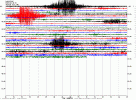
Yes, Yes Yes. I was watching the helicorders the other nite and I couldn't figure out why they were not posting. I got alittle excited. No one else seemed to be looking at it. I then went to other sites and started viewing what I thought was other activity. Thanks to the help of Puterman, I was able to see and hear that some of what I was looking at was railway cars and possibly weather related. But I am still perplexed as to why USGS chose to not post this activity. I have no answers, just more questions.
Yes, Yes Yes. I was watching the helicorders the other nite and I couldn't figure out why they were not posting. I got alittle excited. No one else seemed to be looking at it. I then went to other sites and started viewing what I thought was other activity. Thanks to the help of Puterman, I was able to see and hear that some of what I was looking at was railway cars and possibly weather related. But I am still perplexed as to why USGS chose to not post this activity. I have no answers, just more questions.
reply to post by muzzy
I wondered what your orginal post related to or the point! lol
Thanks for the clarification.
I wondered what your orginal post related to or the point! lol
Thanks for the clarification.
reply to post by muzzy
No, I think I will continue to ignore it.
08/02/2012 05:02:11 5.2 Gulf of Carpentaria
08/02/2012 04:02:14 5.1 Queensland, Australia
08/02/2012 04:02:14 5.1 Queensland, Australia
08/02/2012 01:02:15 6.2 Western Australia
No, I think I will continue to ignore it.
reply to post by kosmicjack
No truth in it. It was either a mine blast or collapse - first registered as a mag 3.4. Unfortunately Dutchnosinse is completely incapable of interpreting a helicorder correctly and does not understand that a node cam be affected by transmission problems. I did actually think at one point that he was learning and was improving. Silly me!
ETA: Explosions, mine blasts etc are not promulgated (as earthquakes) but it is possible to look them up in some instances using ANSS. This is no different to any other agency. BGS get explosions off the UK coast. As soon as they are identified as such they are removed. They are not earthquakes after all!!
@crappiecat
As I mentioned above, they only post earthquakes. Unfortunately with the huge number of events that seismos record it just would not be practical, or indeed possible, to annotate every blip.
No truth in it. It was either a mine blast or collapse - first registered as a mag 3.4. Unfortunately Dutchnosinse is completely incapable of interpreting a helicorder correctly and does not understand that a node cam be affected by transmission problems. I did actually think at one point that he was learning and was improving. Silly me!
ETA: Explosions, mine blasts etc are not promulgated (as earthquakes) but it is possible to look them up in some instances using ANSS. This is no different to any other agency. BGS get explosions off the UK coast. As soon as they are identified as such they are removed. They are not earthquakes after all!!
edit on 24/2/2012 by PuterMan because: (no reason given)
@crappiecat
But I am still perplexed as to why USGS chose to not post this activity.
As I mentioned above, they only post earthquakes. Unfortunately with the huge number of events that seismos record it just would not be practical, or indeed possible, to annotate every blip.
edit on 24/2/2012 by PuterMan because: (no reason given)
wv has a quakes as well yesterday..you have to look it up on the anss...they took it off the map..its a small one but i find it interesting that there
are so many.. and so many not told..
I was actually thinking two times bigger would be 9.2 but hey....what do I know. Thanks for the insight Muzzy and PM!!! xoxox
So...uh....what is going on around Rainier and Hood? If you guys have already addressed it, my apologies as I didn't see where either of you made reference to those two places as of yet...but I anxiously await.
So...uh....what is going on around Rainier and Hood? If you guys have already addressed it, my apologies as I didn't see where either of you made reference to those two places as of yet...but I anxiously await.
edit on 24-2-2012 by MamaJ because: spelling ;-)
new topics
-
Maestro Benedetto
Literature: 1 hours ago -
Is AI Better Than the Hollywood Elite?
Movies: 1 hours ago -
Las Vegas UFO Spotting Teen Traumatized by Demon Creature in Backyard
Aliens and UFOs: 5 hours ago -
2024 Pigeon Forge Rod Run - On the Strip (Video made for you)
Automotive Discussion: 5 hours ago -
Gaza Terrorists Attack US Humanitarian Pier During Construction
Middle East Issues: 6 hours ago -
The functionality of boldening and italics is clunky and no post char limit warning?
ATS Freshman's Forum: 7 hours ago -
Meadows, Giuliani Among 11 Indicted in Arizona in Latest 2020 Election Subversion Case
Mainstream News: 8 hours ago -
Massachusetts Drag Queen Leads Young Kids in Free Palestine Chant
Social Issues and Civil Unrest: 8 hours ago -
Weinstein's conviction overturned
Mainstream News: 9 hours ago -
Supreme Court Oral Arguments 4.25.2024 - Are PRESIDENTS IMMUNE From Later Being Prosecuted.
Above Politics: 11 hours ago
top topics
-
Krystalnacht on today's most elite Universities?
Social Issues and Civil Unrest: 11 hours ago, 9 flags -
Supreme Court Oral Arguments 4.25.2024 - Are PRESIDENTS IMMUNE From Later Being Prosecuted.
Above Politics: 11 hours ago, 8 flags -
University of Texas Instantly Shuts Down Anti Israel Protests
Education and Media: 13 hours ago, 7 flags -
Weinstein's conviction overturned
Mainstream News: 9 hours ago, 7 flags -
Gaza Terrorists Attack US Humanitarian Pier During Construction
Middle East Issues: 6 hours ago, 7 flags -
Massachusetts Drag Queen Leads Young Kids in Free Palestine Chant
Social Issues and Civil Unrest: 8 hours ago, 6 flags -
Meadows, Giuliani Among 11 Indicted in Arizona in Latest 2020 Election Subversion Case
Mainstream News: 8 hours ago, 5 flags -
Las Vegas UFO Spotting Teen Traumatized by Demon Creature in Backyard
Aliens and UFOs: 5 hours ago, 4 flags -
2024 Pigeon Forge Rod Run - On the Strip (Video made for you)
Automotive Discussion: 5 hours ago, 2 flags -
Any one suspicious of fever promotions events, major investor Goldman Sachs card only.
The Gray Area: 15 hours ago, 2 flags
active topics
-
University of Texas Instantly Shuts Down Anti Israel Protests
Education and Media • 232 • : marg6043 -
Post A Funny (T&C Friendly) Pic Part IV: The LOL awakens!
General Chit Chat • 7135 • : underpass61 -
Nearly 70% Of Americans Want Talks To End War In Ukraine
Political Issues • 94 • : Scratchpost -
VP's Secret Service agent brawls with other agents at Andrews
Mainstream News • 62 • : ByeByeAmericanPie -
SETI chief says US has no evidence for alien technology. 'And we never have'
Aliens and UFOs • 72 • : yuppa -
My Poor Avocado Plant.
General Chit Chat • 77 • : JonnyC555 -
New whistleblower Jason Sands speaks on Twitter Spaces last night.
Aliens and UFOs • 61 • : Ophiuchus1 -
Is AI Better Than the Hollywood Elite?
Movies • 2 • : 5thHead -
Gaza Terrorists Attack US Humanitarian Pier During Construction
Middle East Issues • 25 • : CarlLaFong -
Mood Music Part VI
Music • 3102 • : Hellmutt