It looks like you're using an Ad Blocker.
Please white-list or disable AboveTopSecret.com in your ad-blocking tool.
Thank you.
Some features of ATS will be disabled while you continue to use an ad-blocker.

Quake Watch 2012
page: 56share:
reply to post by IzItTrU3
Thank you indeed as it is always good to know that the effort is appreciated BUT I am by no means the only contributor and many others post equally interesting items.
I have looking around your thread here for a little while and I wanted to finally to tell you PuterMan that I truly enjoy reading everything that you post. Even though I alot of it I don't understand. LOL... But on the other hand I really wanted to let you know that.
Thank you indeed as it is always good to know that the effort is appreciated BUT I am by no means the only contributor and many others post equally interesting items.
reply to post by eeks4
What part of WV was this?? Was it on the southern portion along the Appalachians or closer to the Ohio River? I tried looking for it, but it doesn't show up.
What part of WV was this?? Was it on the southern portion along the Appalachians or closer to the Ohio River? I tried looking for it, but it doesn't show up.
reply to post by PuterMan
Love this post--I'm still smiling. Thanks for the handiwork.
Hey PM, this link is from station UW. TDH..SHZ located just a few km from the swarm at Mt. Hood, Oregon. Is the trace at approximately 08:21 UTC an avalanche? (the 7 minute long blue blob)
ETA:
reply to post by MountainEnigma
This link is to the Mag 3.4 Man-made activity. USGS puts it 21 miles WNW of Beckley
edit on 2/24/2012 by Olivine because: eta
edit on 2/24/2012 by Olivine because: fine
tuning
reply to post by Olivine
Nah that's a train!! (Sorry I seem to be saying that a lot recently.)
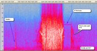
Here is the IRIS version. Looks quite impressive on this one. TDH.UW..EHZ.2012.055
Not sure - off to pull the data........
OK, back again. I did not want to say what I thought it was until I had a listen. As I suspected it is electrical / transmission/ ionospheric or maybe a tessla ray.
It is not seismic, i.e. not a quake, not a rock fall or avalanche, and not volcanic.
Nah that's a train!! (Sorry I seem to be saying that a lot recently.)
Here is the IRIS version. Looks quite impressive on this one. TDH.UW..EHZ.2012.055
Not sure - off to pull the data........
OK, back again. I did not want to say what I thought it was until I had a listen. As I suspected it is electrical / transmission/ ionospheric or maybe a tessla ray.
It is not seismic, i.e. not a quake, not a rock fall or avalanche, and not volcanic.

edit on 24/2/2012 by PuterMan because: (no reason given)
reply to post by PuterMan
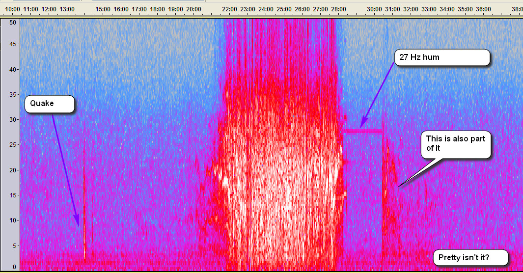
That was fast....and it is pretty.
I will be adding your images to my file with all the other samples--my seismo resources of what-is-what.
Thank you Sir!
Goodnight
That was fast....and it is pretty.
I will be adding your images to my file with all the other samples--my seismo resources of what-is-what.
Thank you Sir!
Goodnight
reply to post by Olivine
Afore ye rush off you might want to hear it.
UW_TDH _EHZ_20120224-080000_2000sps.wav
By the way right at the start the signal looks like and sounds like a helicopter for a second. This is pure supposition - helicopter signal on
seismo but then too close and causes interference? I say this because at the exit of the sounds it again sounds like a helicopter of a second or so.
Only problem is that would be 1 am or thereabouts. Possible? I don't know.
I would love to have PNSN look at this one.
After listening again and checking back on other siesmos I see the signal on other days, and fainter on TIMB/HOOD. I am flipping back to electrical and local and guessing something going on at/from Government Camp? Maybe.
Afore ye rush off you might want to hear it.
UW_TDH _EHZ_20120224-080000_2000sps.wav
I would love to have PNSN look at this one.
After listening again and checking back on other siesmos I see the signal on other days, and fainter on TIMB/HOOD. I am flipping back to electrical and local and guessing something going on at/from Government Camp? Maybe.
edit on 24/2/2012 by PuterMan because: (no reason given)
From elementary geography we have learnt the concept of tectonic plates boundaries. So it is common sense that in the event of a major earthquake if a
piece of land is inundated by the ocean, a piece of land has to emerge from the ocean, for, the amount of water is constant on the earth.
Yet, my question is whether it is possible that large chunks of land sink into the ocean without equal land area emerging from the ocean. I tried to reason this myself, but was not convinced that it is a possible, may be I am missing something, which the members of ATS could tell me.
Yet, my question is whether it is possible that large chunks of land sink into the ocean without equal land area emerging from the ocean. I tried to reason this myself, but was not convinced that it is a possible, may be I am missing something, which the members of ATS could tell me.
This event has been reviewed by a seismologist.
Magnitude
4.4
Date-Time
Saturday, February 25, 2012 at 05:17:15 UTC
Friday, February 24, 2012 at 09:17:15 PM at epicenter
Location
40.286°N, 124.323°W
Depth
20 km (12.4 miles)
Region
NORTHERN CALIFORNIA
Distances
5 km (3 miles) SW (217°) from Petrolia, CA
30 km (19 miles) SW (218°) from Rio Dell, CA
33 km (20 miles) S (189°) from Ferndale, CA
58 km (36 miles) SSW (194°) from Eureka, CA
USGS
Earthquake Details
This event has been reviewed by a seismologist.
Magnitude
4.4
Date-Time
Saturday, February 25, 2012 at 05:17:15 UTC
Friday, February 24, 2012 at 09:17:15 PM at epicenter
Time of Earthquake in other Time Zones
Location
40.286°N, 124.323°W
Depth
20 km (12.4 miles)
Region
NORTHERN CALIFORNIA
Distances
5 km (3 miles) SW (217°) from Petrolia, CA
30 km (19 miles) SW (218°) from Rio Dell, CA
33 km (20 miles) S (189°) from Ferndale, CA
58 km (36 miles) SSW (194°) from Eureka, CA
312 km (194 miles) NW (309°) from Sacramento, CA
Location Uncertainty
horizontal +/- 1.3 km (0.8 miles); depth +/- 0.7 km (0.4 miles)
Parameters
Nph= 16, Dmin=4 km, Rmss=0.17 sec, Gp=194°,
M-type=regional moment magnitude (Mw), Version=5
Source
California Integrated Seismic Net:
USGSCaltechCGSUCBUCSDUNR
Event ID
nc71741671
Did you feel it? Report shaking and damage at your location. You can also view a map displaying accumulated data from your report and others.
Magnitude
5.2
Date-Time
Saturday, February 25, 2012 at 06:15:12 UTC
Saturday, February 25, 2012 at 05:15:12 PM at epicenter
Location
49.197°N, 155.949°E
Depth
23.1 km (14.4 miles)
Region
KURIL ISLANDS
USGS
Magnitude
5.3
Date-Time
Saturday, February 25, 2012 at 06:18:04 UTC
Saturday, February 25, 2012 at 05:18:04 PM at epicenter
Location
49.293°N, 155.860°E
Depth
23.4 km (14.5 miles)
Region
KURIL ISLANDS
USGS
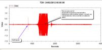
Originally posted by PuterMan
reply to post by Olivine
Afore ye rush off you might want to hear it.
UW_TDH _EHZ_20120224-080000_2000sps.wav
By the way right at the start the signal looks like and sounds like a helicopter for a second. This is pure supposition - helicopter signal on seismo but then too close and causes interference? I say this because at the exit of the sounds it again sounds like a helicopter of a second or so. Only problem is that would be 1 am or thereabouts. Possible? I don't know.
I would love to have PNSN look at this one.
After listening again and checking back on other siesmos I see the signal on other days, and fainter on TIMB/HOOD. I am flipping back to electrical and local and guessing something going on at/from Government Camp? Maybe.
edit on 24/2/2012 by PuterMan because: (no reason given)
Oh.....my goodness. Sounds like you picked up an alien transmission!!!
I sent it off to PNSN
reply to post by ksh99
First welcome to ATS and to quake watch.
Here you will find some of the best information about earthquakes on the Internet. Why do I say that? Because the members who frequent this thread, and those who lurk and occasionally stick their heads up into the firing line on the whole produce excellent work that is based on facts.
You will find some of the alternative geophysical theories on this thread: Geophysics which is hosted by Zenius who you will also see on this thread.
Anything of a speculative nature to do with Yellowstone / Fracking / Arkansas / Bird Deaths / Hudson Bay / Life / Death / Resurrection / the Economy / Politics / Religion etc you can post on the thread hosted by Robin Marks/Eric Blair: Robinesque Ruminations
Volcano stuff you will find on Volcano Watch and last but by no means least the giant Yellowstone thread is a BIG read all about the Park that has passed page 700.
These and more ATS links, and links to many external sites you can find in my signature block and in the signatures of others.
Never be afraid to ask a question. We will always try to answer, and no one gets ridiculed here because of a lack of knowledge on what is a complex and multifaceted subject.
So........
Is it? How so? Have a think about that again. A piece of land can sink and the ocean flow over it, and a piece of ocean floor rise and the the water flow off it. Neither event requires any change in the volume of water, only in the shape of the container. If all the land levelled out and all the ocean bed was levelled out, there would be endless ocean approximately 2.5 kilometres deep all over the globe. This would not require any change in the volume of water.
First welcome to ATS and to quake watch.
Here you will find some of the best information about earthquakes on the Internet. Why do I say that? Because the members who frequent this thread, and those who lurk and occasionally stick their heads up into the firing line on the whole produce excellent work that is based on facts.
You will find some of the alternative geophysical theories on this thread: Geophysics which is hosted by Zenius who you will also see on this thread.
Anything of a speculative nature to do with Yellowstone / Fracking / Arkansas / Bird Deaths / Hudson Bay / Life / Death / Resurrection / the Economy / Politics / Religion etc you can post on the thread hosted by Robin Marks/Eric Blair: Robinesque Ruminations
Volcano stuff you will find on Volcano Watch and last but by no means least the giant Yellowstone thread is a BIG read all about the Park that has passed page 700.
These and more ATS links, and links to many external sites you can find in my signature block and in the signatures of others.
Never be afraid to ask a question. We will always try to answer, and no one gets ridiculed here because of a lack of knowledge on what is a complex and multifaceted subject.
So........
So it is common sense that in the event of a major earthquake if a piece of land is inundated by the ocean, a piece of land has to emerge from the ocean, for, the amount of water is constant on the earth.
Is it? How so? Have a think about that again. A piece of land can sink and the ocean flow over it, and a piece of ocean floor rise and the the water flow off it. Neither event requires any change in the volume of water, only in the shape of the container. If all the land levelled out and all the ocean bed was levelled out, there would be endless ocean approximately 2.5 kilometres deep all over the globe. This would not require any change in the volume of water.
Magnitude
4.3
Date-Time
Saturday, February 25, 2012 at 10:27:19 UTC
Saturday, February 25, 2012 at 11:27:19 PM at epicenter
Time of Earthquake in other Time Zones
Location
43.459°S, 172.964°E
Depth
10.3 km (6.4 miles)
Region
SOUTH ISLAND OF NEW ZEALAND
Distances
25 km (15 miles) ENE of Christchurch, New Zealand
220 km (136 miles) SSE of Westport, New Zealand
283 km (175 miles) SSW of WELLINGTON, New Zealand
331 km (205 miles) NE of Dunedin, New Zealand
Location Uncertainty
horizontal +/- 10.4 km (6.5 miles); depth +/- 5 km (3.1 miles)
Parameters
NST= 19, Nph= 26, Dmin=30.1 km, Rmss=1.04 sec, Gp=180°,
M-type=local magnitude (ML), Version=5
Source
Magnitude: Inst. of Geological and Nuclear Sciences, Lower Hutt, New Zealand
Location: USGS NEIC (WDCS-D)
Event ID
usb00085rm
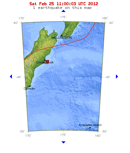
earthquake.usgs.gov...
Originally posted by PuterMan
reply to post by Olivine
Afore ye rush off you might want to hear it.
UW_TDH _EHZ_20120224-080000_2000sps.wav
Sorry 'bout my quick exit--I'm sort of a hockey nut, and the game was starting...
That station sounded so lonely for the first bit, then "Bam" ....sounded like static as first..but I think westcoast nailed it--Aliens.
@westcoast--thanks for forwarding to PNSN, I'm curious to get their input.
Magnitude mb 4.1
Region SOUTHWESTERN SIBERIA, RUSSIA
Date time 2012-02-25 13:14:12.5 UTC
Location 51.37 N ; 96.15 E
Depth 15 km
Distances 128 km E Kyzyl (pop 108,240 ; local time 20:14:12.5 2012-02-25)
104 km E Kaa-khem (pop 10,375 ; local time 20:14:12.5 2012-02-25)
41 km E Saryg-sep (pop 4,582 ; local time 20:14:12.5 2012-02-25)
EMSC
You are right puterman... To everyone else that has posted on the thread, thank you for all the great information... I have enjoyed reading everyones
input on earthquakes. This is a very interesting, educating thread. Keep up the great work everyone, I am looking foward to reading so much more in
this thread and the others.....
Have a great day all!!!!!
Have a great day all!!!!!
reply to post by Hellas
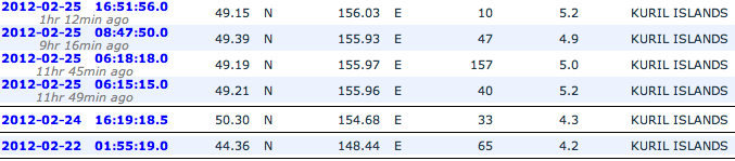
Only 4 on USGS - four shocks you could say
Date/Time UTC,Latitude,Longitude,Magnitude,Depth(Km),Location
2012-02-25 16:51:56, 49.171, 156.192, 5.0, 15.8, Kuril Isls.
2012-02-25 08:47:47, 49.372, 155.982, 4.9, 26.4, Kuril Isls.
2012-02-25 06:18:04, 49.293, 155.860, 5.3, 23.4, Kuril Isls.
2012-02-25 06:15:12, 49.196, 155.948, 5.2, 23.1, Kuril Isls.
Only 4 on USGS - four shocks you could say
Magnitude ML 4.2
Region SICILY, ITALY
Date time 2012-02-25 20:34:36.1 UTC
Location 38.43 N ; 13.61 E
Depth 10 km
Distances 41 km NE Palermo (pop 672,175 ; local time 21:34:36.1 2012-02-25)
38 km N Santa flavia (pop 10,328 ; local time 21:34:36.1 2012-02-25)
EMSC
new topics
-
Happy St George's day you bigots!
Breaking Alternative News: 26 minutes ago -
TLDR post about ATS and why I love it and hope we all stay together somewhere
General Chit Chat: 1 hours ago -
Hate makes for strange bedfellows
US Political Madness: 3 hours ago -
Who guards the guards
US Political Madness: 6 hours ago -
Has Tesla manipulated data logs to cover up auto pilot crash?
Automotive Discussion: 7 hours ago
top topics
-
Hate makes for strange bedfellows
US Political Madness: 3 hours ago, 13 flags -
CIA botched its handling of sexual assault allegations, House intel report says
Breaking Alternative News: 17 hours ago, 11 flags -
whistleblower Captain Bill Uhouse on the Kingman UFO recovery
Aliens and UFOs: 12 hours ago, 10 flags -
Who guards the guards
US Political Madness: 6 hours ago, 10 flags -
1980s Arcade
General Chit Chat: 15 hours ago, 6 flags -
Teenager makes chess history becoming the youngest challenger for the world championship crown
Other Current Events: 16 hours ago, 5 flags -
Deadpool and Wolverine
Movies: 15 hours ago, 4 flags -
TLDR post about ATS and why I love it and hope we all stay together somewhere
General Chit Chat: 1 hours ago, 3 flags -
Has Tesla manipulated data logs to cover up auto pilot crash?
Automotive Discussion: 7 hours ago, 2 flags -
Happy St George's day you bigots!
Breaking Alternative News: 26 minutes ago, 1 flags
active topics
-
MULTIPLE SKYMASTER MESSAGES GOING OUT
World War Three • 98 • : cherokeetroy -
Hate makes for strange bedfellows
US Political Madness • 26 • : theatreboy -
Candidate TRUMP Now Has Crazy Judge JUAN MERCHAN After Him - The Stormy Daniels Hush-Money Case.
Political Conspiracies • 699 • : Lazy88 -
Old School Punk
Music • 539 • : underpass61 -
Happy St George's day you bigots!
Breaking Alternative News • 7 • : SprocketUK -
Scientists Say Even Insects May Be Sentient
Science & Technology • 56 • : Naftalin -
UN warns Assange may be tortured if extradited to US
Whistle Blowers and Leaked Documents • 14 • : burritocat -
"We're All Hamas" Heard at Columbia University Protests
Social Issues and Civil Unrest • 239 • : network dude -
Mandela Effect - It Happened to Me!
The Gray Area • 113 • : chris_stibrany -
TLDR post about ATS and why I love it and hope we all stay together somewhere
General Chit Chat • 4 • : theatreboy