It looks like you're using an Ad Blocker.
Please white-list or disable AboveTopSecret.com in your ad-blocking tool.
Thank you.
Some features of ATS will be disabled while you continue to use an ad-blocker.

Quake Watch 2012
page: 54share:
So I'm perusing through usgs.gov. Here are quakes in the last hour, in red.
earthquake.usgs.gov...
Northwest, only abouts a one. I shouldn't of felt that. But I felt that Oklahoma one, sometime back, and i should'nta felt that'un either. But then someone in VA said they had felt the Oklahoma one.
earthquake.usgs.gov...
Northwest, only abouts a one. I shouldn't of felt that. But I felt that Oklahoma one, sometime back, and i should'nta felt that'un either. But then someone in VA said they had felt the Oklahoma one.
reply to post by Saucerwench
All the helicorders in MO. are showing something is giggling. I can't find Marked tree. Where are you finding that one?
Sorry, that question was for Berkleygal.
Found it!!
All the helicorders in MO. are showing something is giggling. I can't find Marked tree. Where are you finding that one?
Sorry, that question was for Berkleygal.
edit on 22-2-2012 by crappiekat because: (no reason given)
' Found it!!
edit on 22-2-2012 by crappiekat because: (no reason given)
reply to post by crappiekat
www.ceri.memphis.edu...
you will see this, click the Marked Tree node
Shortperiod CERI stations:
CERI node
Marked Tree node
Lennox node
New Madrid node
Morristown node
Star Mt. node
Mt. Gibbes node
www.ceri.memphis.edu...
you will see this, click the Marked Tree node
Shortperiod CERI stations:
CERI node
Marked Tree node
Lennox node
New Madrid node
Morristown node
Star Mt. node
Mt. Gibbes node
reply to post by berkeleygal It
Thank you, I found it. What ever it is, it seems to gaining a little speed again
I"ve been watching the helicorders in MO. Stahl farm, one of them. Thats where Im seeing something ramping up.
Thank you, I found it. What ever it is, it seems to gaining a little speed again
I"ve been watching the helicorders in MO. Stahl farm, one of them. Thats where Im seeing something ramping up.
edit on 22-2-2012 by
crappiekat because: (no reason given)
reply to post by SpaceJockey1
seems we are back to background seismicity for NZ
15th Mag 5+ for 2010
4th Mag 5+ for February (all in the North Island BTW)
that one 26km NE of the last one on the 8th Feb
I was expecting something 4.8ish for Cook Strait next, maybe those 4.9's at Wanganui and Sth Taranaki Bight on Sunday and Monday took the stress off CS.
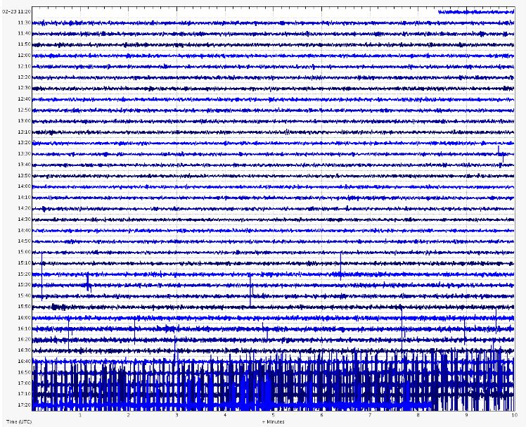
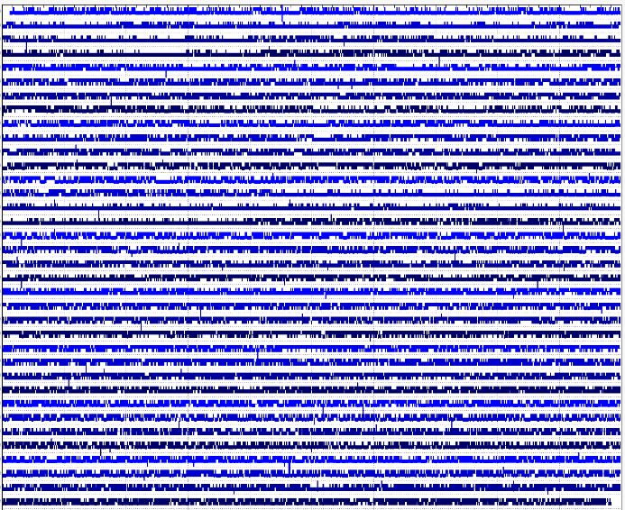
PM, berkeleygal or anyone. Im trying to understand seismic waveforms. In the below waveforms from Huckleberry Mtn, doesnt the below indicate seismic
activity. And if so why does it go on for so long and why is it not recorded in EQ maps.
reply to post by zworld
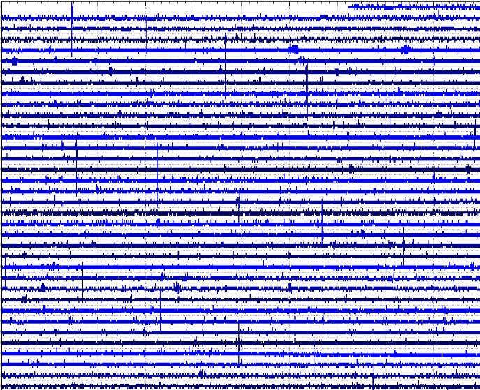
Which seismo is this? Closest i can find to HM is this one which is showing the same signals (sort of) YMS.WY..EHZ.2012.054
Storms in the area? MCID.WY..EHZ.2012.054 or problems YPP.WY..EHZ.2012.054
Is it very cold around YNP? These seismos are all sent by microwave (or at least were) and there can be transmission problems from icing. LKWY.US.00.LHZ.2012.054 is a satellite seismo and is not affected the same, and basically is showing nothing.
These were supposed to be going onto a broadband connection sometime but I have no idea if that has happened yet.
edit on 23/2/2012 by PuterMan because: (no reason given)
reply to post by crappiekat
What is it that you are looking at? Is it the big 'splodges' on this one?
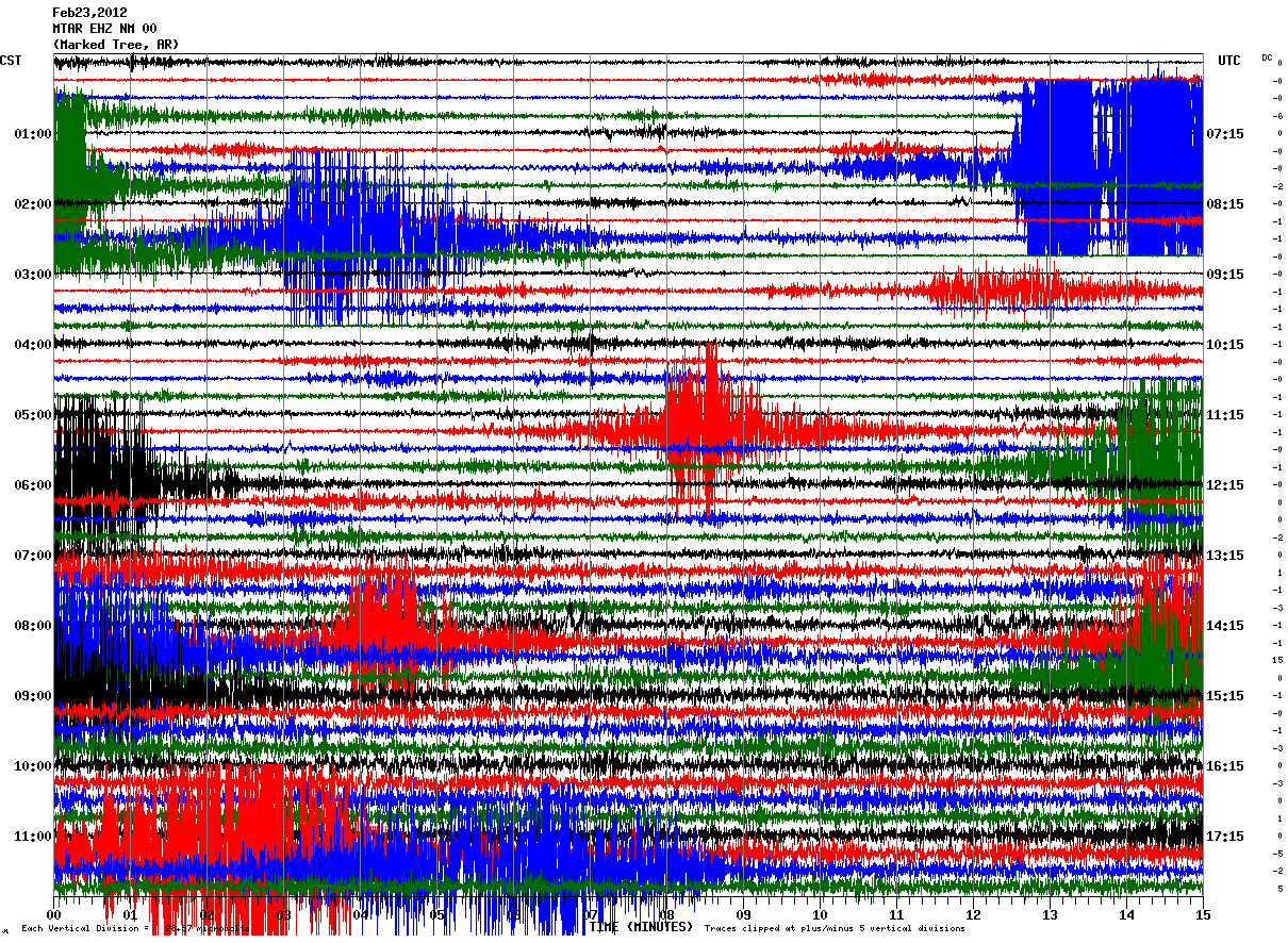
I can pretty much guarantee you that is trains. I don't know where the marked tree seismo is, but I am assuming somewhere in Marked Tree and there is a double track railroad runs through the town. Looks like some heavy stuff going through in the middle of the night.
The sensitivity is only (I think it says) 28.67 mV which is very sensitive and I query why thy would have it set that sensitive when there is so much noise in the area.
What is it that you are looking at? Is it the big 'splodges' on this one?
I can pretty much guarantee you that is trains. I don't know where the marked tree seismo is, but I am assuming somewhere in Marked Tree and there is a double track railroad runs through the town. Looks like some heavy stuff going through in the middle of the night.
The sensitivity is only (I think it says) 28.67 mV which is very sensitive and I query why thy would have it set that sensitive when there is so much noise in the area.
reply to post by PuterMan
Thank you for looking at this. The more I was checking other sites, I was kinda thinking it might be something manmade. I'm still learning how to read these things. I will be doing more homework tonight after work, but for now I must go.
Thank you again. I appreciate all your patience with someone like me who has alot of learning to do.
I just read this article and wanted to share. I am sooooo nice... I know.
The article is from seattletimes.nwsource.com...
It talks about the Japan quake and the fact that if a similar quake happened in the Cascadia Subduction Zone it would leave a lot of cities in ruins. I think we knew that already but I guess now they have data to back up the claims.
The article is from seattletimes.nwsource.com...
It talks about the Japan quake and the fact that if a similar quake happened in the Cascadia Subduction Zone it would leave a lot of cities in ruins. I think we knew that already but I guess now they have data to back up the claims.
Originally posted by muzzy
reply to post by SpaceJockey1
seems we are back to background seismicity for NZ
15th Mag 5+ for2010[color=F88017 ]2012
4th Mag 5+ for February (all in the North Island BTW)
that one 26km NE of the last one on the 8th Feb
I was expecting something 4.8ish for Cook Strait next, maybe those 4.9's at Wanganui and Sth Taranaki Bight on Sunday and Monday took the stress off CS.
2012, 2012, 2012, 2012, 2012, 2012
I'll get it by December
Originally posted by PuterMan
reply to post by zworld
Which seismo is this
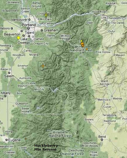
Thanks PuterMan. The reason Im interested in that area is because of whats happening north at hood and rainer and possible magma flow. Below is showing where the first waveform was from and it's proximity to Mt. Bachelor, Broken Top and the Three Sisters, center of historical volcanic activity in the CSZ. Note Mt. Hood activity.
And this is north showing both Hood and Mt Rainer activity.
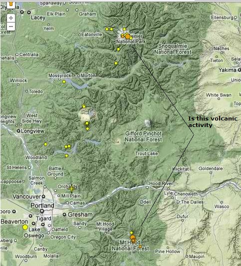
And these are recent waveforms for first hood and then rainer. Does any of this look like magmatic activity to anyone.
edit on 23-2-2012 by zworld because: (no reason given)
reply to post by MamaJ
in there;
"Some geologists argue the magnitude-9 quake 300 years ago was simply average and that the Northwest has been slammed by quakes twice as big in the distant past."
Wot a load of codswallup, there is no such thing as a Mag 18
maybe 10's of millions of years ago when the earths plates were forming into their present shape perhaps, before the North American continent even existed in its present form, and 50% of the crust was molten lava.
I didn't read any more after that.
Its scaremongering by the journalists
in there;
"Some geologists argue the magnitude-9 quake 300 years ago was simply average and that the Northwest has been slammed by quakes twice as big in the distant past."
Wot a load of codswallup, there is no such thing as a Mag 18
maybe 10's of millions of years ago when the earths plates were forming into their present shape perhaps, before the North American continent even existed in its present form, and 50% of the crust was molten lava.
edit on 23-2-2012 by muzzy because: (no reason given)
I didn't read any more after that.
Its scaremongering by the journalists
edit on 23-2-2012 by muzzy because: (no reason given)
Thats what I was watching last nite and couldn't figure out why they weren't posting them.
I have to learn how to take pictures of what I'm looking at (along with a lot more).
I have 3 computer savy teenage boys and I can never pin one down to teach me.
This post was in regards to the MO. add ons. SCGrits.
Jeez, sorry so goofey right now just got off work.
edit on 23-2-2012 by crappiekat because: editing
If you go to the stahl farm, MO and the other two helicorders, you can see they just had another one. Just like last nite, things are giggling in MO.
edit on 23-2-2012 by crappiekat because: (no reason given)
It also looks like we have alittle action on the Hopedale,il helicorder. I think we got something brewing here on the New Madrid.
edit on
23-2-2012 by crappiekat because: (no reason given)
Originally posted by muzzy
reply to post by MamaJ
in there;
"Some geologists argue the magnitude-9 quake 300 years ago was simply average and that the Northwest has been slammed by quakes twice as big in the distant past."
Wot a load of codswallup, there is no such thing as a Mag 18
maybe 10's of millions of years ago when the earths plates were forming into their present shape perhaps, before the North American continent even existed in its present form, and 50% of the crust was molten lava.edit on 23-2-2012 by muzzy because: (no reason given)
I didn't read any more after that.
Its scaremongering by the journalistsedit on 23-2-2012 by muzzy because: (no reason given)
Actually, it is a logarithmic scale. Each increase in 1 is equal to 10 times. I'm pretty sure that's how it works. That would mean a magnitude 10 is ten times as strong as a magnitude 9. It is quite possible that there has been an earthquake twice as strong as a magnitude 9 because that would be less than magnitude 10. That's how I would understand that quote. A magnitude 10 would be 100 times stronger than a magnitude 8.
reply to post by PuterMan
PuterMan, I live close to Marked Tree, although I've not been there for several years, so I can't tell you where the seismo is located or about any railroad tracks.
I can say that it's been extremely windy today, enough so that the windows and doors are constantly rattling. The gusts are in the 40-50 mph range and higher. Would that be the cause of the odd graph shown from Marked Tree?
reply to post by phoenixlights321
Yes you are absolutely right
I didn't think it through.
so the calculation, based on energy released would be;
one Mag 9.0 = 476879138.377 TTNT
add Mag 9.0 = 476879138.377 TTNT
added together = 953758276.754 TTNT
= Mag 9.20067 = 953703385.116 TTNT
Given that, I wonder how many people who don't normally bother about such things thought the same as I did?
why didn't they just say 9.2 instead of "twice as big" which may confuse people
edit on 24-2-2012 by muzzy because: (no reason given)
Hi Guys
Last Night excactly on almost the same spot as 2 weeks ago, we had an earthquake again, this time only a 3.5.
Was felt at some places and there was either a loud bang or a weird sound to be heard.
Here are the details:
Date & Time: 2012/02/24 00:32:29 UTC
Latitude: 47.14 N Longitude: 8.54 E
Magnitude : 3.5 Magnitude Type : Ml
CH-coordinates X: 683161 Y: 221916
Depth (Km): 33.0
Location Type: manual
Agency: SED
Swiss Quake
quakes.globalincidentmap.com...
Type: Earthquake
Magnitude: 4.1
DateTime: Friday February 24 2012, 07:02:24 UTC
Region: Island of Hawaii, Hawaii
Depth: 5.2 km
Source: USGS Feed
Friday February 24 2012, 07:40:12 UTC 5 minutes ago Island of Hawaii, Hawaii 1.8
Friday February 24 2012, 07:29:08 UTC 16 minutes ago Island of Hawaii, Hawaii 1.8
Friday February 24 2012, 07:28:38 UTC 17 minutes ago Island of Hawaii, Hawaii 2.0
Friday February 24 2012, 07:24:43 UTC 21 minutes ago Island of Hawaii, Hawaii 2.3
Friday February 24 2012, 07:12:25 UTC 33 minutes ago Island of Hawaii, Hawaii 2.2
Friday February 24 2012, 07:09:16 UTC 36 minutes ago Island of Hawaii, Hawaii 1.9
Friday February 24 2012, 07:07:50 UTC 38 minutes ago Island of Hawaii, Hawaii 1.7
Friday February 24 2012, 07:05:04 UTC 40 minutes ago Island of Hawaii, Hawaii 2.5
Friday February 24 2012, 07:02:24 UTC 43 minutes ago Island Of Hawaii, Hawaii 4.1
Detail
edit on 4/5/2011 by dreamfox1 because: (info)
edit on 4/5/2011 by dreamfox1 because: ???
new topics
-
Are you ready for the return of Jesus Christ? Have you been cleansed by His blood?
Religion, Faith, And Theology: 1 hours ago -
Chronological time line of open source information
History: 3 hours ago -
A man of the people
Diseases and Pandemics: 4 hours ago -
Ramblings on DNA, blood, and Spirit.
Philosophy and Metaphysics: 4 hours ago -
4 plans of US elites to defeat Russia
New World Order: 6 hours ago -
Thousands Of Young Ukrainian Men Trying To Flee The Country To Avoid Conscription And The War
Other Current Events: 9 hours ago
top topics
-
Israeli Missile Strikes in Iran, Explosions in Syria + Iraq
World War Three: 12 hours ago, 17 flags -
Iran launches Retalliation Strike 4.18.24
World War Three: 12 hours ago, 6 flags -
Thousands Of Young Ukrainian Men Trying To Flee The Country To Avoid Conscription And The War
Other Current Events: 9 hours ago, 6 flags -
12 jurors selected in Trump criminal trial
US Political Madness: 12 hours ago, 4 flags -
4 plans of US elites to defeat Russia
New World Order: 6 hours ago, 2 flags -
A man of the people
Diseases and Pandemics: 4 hours ago, 2 flags -
Chronological time line of open source information
History: 3 hours ago, 2 flags -
Ramblings on DNA, blood, and Spirit.
Philosophy and Metaphysics: 4 hours ago, 1 flags -
Are you ready for the return of Jesus Christ? Have you been cleansed by His blood?
Religion, Faith, And Theology: 1 hours ago, 1 flags
active topics
-
Biden--My Uncle Was Eaten By Cannibals
US Political Madness • 51 • : YourFaceAgain -
Are you ready for the return of Jesus Christ? Have you been cleansed by His blood?
Religion, Faith, And Theology • 8 • : RAY1990 -
Thousands Of Young Ukrainian Men Trying To Flee The Country To Avoid Conscription And The War
Other Current Events • 12 • : ScarletDarkness -
So I saw about 30 UFOs in formation last night.
Aliens and UFOs • 33 • : Encia22 -
Israeli Missile Strikes in Iran, Explosions in Syria + Iraq
World War Three • 66 • : DBCowboy -
Two Serious Crimes Committed by President JOE BIDEN that are Easy to Impeach Him For.
US Political Madness • 18 • : xuenchen -
12 jurors selected in Trump criminal trial
US Political Madness • 34 • : Vermilion -
Russian intelligence officer: explosions at defense factories in the USA and Wales may be sabotage
Weaponry • 174 • : Oldcarpy2 -
BREAKING: O’Keefe Media Uncovers who is really running the White House
US Political Madness • 18 • : interupt42 -
911 emergency lines are DOWN across multiple states
Breaking Alternative News • 7 • : mysterioustranger