It looks like you're using an Ad Blocker.
Please white-list or disable AboveTopSecret.com in your ad-blocking tool.
Thank you.
Some features of ATS will be disabled while you continue to use an ad-blocker.

Quake Watch 2012
page: 229share:
012-09-26 00:05:29 UTC
2012-09-25 18:05:29 UTC-06:00 at epicenter
2012-09-25 20:05:29 UTC-04:00 system time
Nearby Cities
38km (24mi) N of La Paz, Mexico
152km (94mi) ESE of Ciudad Constitucion, Mexico
170km (106mi) NNW of San Jose del Cabo, Mexico
182km (113mi) NNW of Cabo San Lucas, Mexico
1006km (625mi) S of Phoenix, Arizona
5.1 earthquake, 71km E of `Ohonua, Tonga. Sep 25 13:41 at epicenter (depth 43km).
2012-09-26 01:41:43 UTC
2012-09-25 13:41:43 UTC-12:00 at epicenter
2012-09-25 21:41:43 UTC-04:00 system time
Nearby Cities
71km (44mi) E of `Ohonua, Tonga
96km (60mi) E of Nuku`alofa, Tonga
836km (519mi) ESE of Suva, Fiji
849km (528mi) SSW of Tafuna, American Samoa
853km (530mi) SE of Lambasa, Fiji
4.6 earthquake, 159km SSE of Kas, Turkey. Sep 26 03:28 at epicenter (depth 29km)
2012-09-26 01:28:32 UTC
2012-09-26 03:28:32 UTC+02:00 at epicenter
2012-09-25 21:28:32 UTC-04:00 system time
Nearby Cities
159km (99mi) SSE of Kas, Turkey
160km (99mi) S of Demre, Turkey
161km (100mi) S of Demre, Turkey
172km (107mi) S of Beykonak, Turkey
311km (193mi) W of Nicosia, Cyprus
5.1 earthquake, 280km ESE of L'Esperance Rock, New Zealand. Sep 25 17:24 at epicenter (depth 39km)
2012-09-26 05:24:32 UTC
2012-09-25 17:24:32 UTC-12:00 at epicenter
2012-09-26 01:24:32 UTC-04:00 system time
Nearby Cities
280km (174mi) ESE of L'Esperance Rock, New Zealand
855km (531mi) NE of Gisborne, New Zealand
861km (535mi) NE of Whakatane, New Zealand
897km (557mi) NE of Tauranga, New Zealand
1257km (781mi) NE of Wellington, New Zealand
5.2 earthquake, 155km W of Neiafu, Tonga. Sep 25 18:45 at epicenter ( depth 162km).
2012-09-26 06:45:18 UTC
2012-09-25 18:45:18 UTC-12:00 at epicenter
2012-09-26 02:45:18 UTC-04:00 system time
Nearby Cities
155km (96mi) W of Neiafu, Tonga
253km (157mi) N of Nuku`alofa, Tonga
611km (380mi) ESE of Lambasa, Fiji
650km (404mi) E of Suva, Fiji
680km (423mi) SW of Apia, Samoa
2012-09-26 06:45:18 UTC
2012-09-25 18:45:18 UTC-12:00 at epicenter
2012-09-26 02:45:18 UTC-04:00 system time
Nearby Cities
155km (96mi) W of Neiafu, Tonga
253km (157mi) N of Nuku`alofa, Tonga
611km (380mi) ESE of Lambasa, Fiji
650km (404mi) E of Suva, Fiji
680km (423mi) SW of Apia, Samoa
reply to post by earthmoney123
So glad we cleared that up as I did not want to launch into a long post about it.
Nibiru does not exist as you say and you can rest assured that if it did, and was close enough to have any effect, the numerous astronomers and more importantly the even more numerous amateur astronomers WOULD have seen it.
No source of earthquakes from that direction I am afraid.
reply to post by kennvideo
Now then kv, I do believe you missed one which actually is much more interesting than the others which are well shall we say 'normal'?
Location in Google Maps
Derived from Event Data Source: USGS
Powered by QVSData
They are not as rare as hen's teeth as there are quite a few (300 km radius) on the list, but only a few every year.
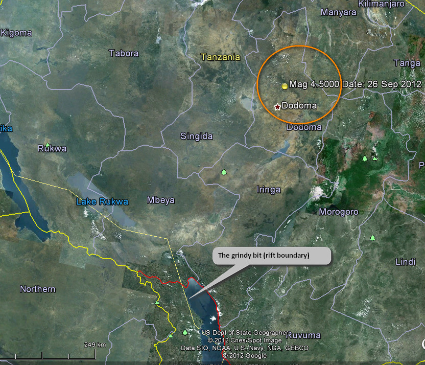
Some distance from the grindy bit and not an area I am familiar with but may Aromaz can shed some light if passing this way?
Now then kv, I do believe you missed one which actually is much more interesting than the others which are well shall we say 'normal'?
Magnitude 4.5 - Tanzania
Location in Google Maps
- Date-Time: Wednesday, September 26, 2012 @ 13:14:20 UTC
- Earthquake location: 5.770°S, 35.885°E,
- Earthquake depth: 10.0 km
- Distances:
35km (21mi) NNW of Msanga, Tanzania
47km (29mi) NNE of Dodoma, Tanzania
75km (46mi) NW of Kongwa, Tanzania
92km (57mi) NW of Mpwapwa, Tanzania
392km (243mi) WNW of Dar es Salaam, Tanzania
- Event ID: us2012fzay
Derived from Event Data Source: USGS
Powered by QVSData
They are not as rare as hen's teeth as there are quite a few (300 km radius) on the list, but only a few every year.
Some distance from the grindy bit and not an area I am familiar with but may Aromaz can shed some light if passing this way?
edit on 26/9/2012 by PuterMan because: titivation
I am so right. I tried erasing that statement as soon as I wrote it- but damn- it's true- so put it back in.
Last April, after a very boring few weeks of quake-watching, there were two very large quakes off Indonesia. The quakes were strange for various reasons, all of which have been cover by numerous studies. The map of that particular faulting was as messy as a pizza delivery boy's road atlas. Arrows every which way. Those earthquakes did more than just confuse geologists, those two extra big bumps shook the whole damn world and triggered lots and lots of other earthquakes. You could say, these two earthquakes mated and had baby earthquakes.
www.usgs.gov...
I don't know why I have to like reading. The damn study on Wyoming water was what I was after.
Last April I stated that all that activity was interrelated. It was an exceptional moment because it was out of the ordinary and this made the contrast so glaring and obvious. It was more a bit beyond statistics and more than just coincidental. It wasn't just me who was noting at the time that it had been ghostly quiet. I was tiring of my own joke that it was like a war movie or something where a person notes it's a little "too" quiet. Gosh, scientist should stick to science stuff and leave the writing to writers. That analogy in the article comparing it to an apple tree was silly. Apples. Even the Newton story about the apple tree is fiction and never happened. What's the deal with the apple tree??? I digress.
Last April the whole world was resonating as if all the church's bells were ringing at once. Almost as if a message was being passed from one watchtower to the next in vast chain forts. I think this study is important because before this admission of guilt, most of the geological community was set on viewing earthquakes as local. For me there was never a debate. I couldn't see how earthquakes and seismic zones would release all that energy in isolation. They don't. It is obvious when you have a thrust-fault that causes a tsunami. That wave can travel right around the world. So, how can seismic waves pass 'round and 'round like the Sumatra quake and nothing happen elsewhere? Even if it's not a large push, it's still a shove that sends a body down over a cliff. Sometimes a nudge is enough.
But more important that the notion that earthquakes don't like borders and zones, is that it demonstrates to me that all things are in one way or another, inter-connected and interrelated.
So, maybe everything is connected. Like that African quake. Just for fun I looked at the satellite map. It appears there's lots of farming in the area. I was looking for mines and other activity. Because we can't assume all earthquakes are natural. At first I thought it was a clear cut forest. No.
But with farming we have irrigation. Especially in a hot Africa. So. Maybe the earthquake was from a depleted aquifer. Who knows? Right?
Oh, here's that report on Pavillion, Wyoming...
www.usgs.gov...
One last thought. Yes, after the two biggies in Indonesia, there was an uptick in activity all over the place. But what about the quiet before hand. There is the before, the during, and the after.
So, the question must be asked. Was it all part of a larger dynamic?
In the quiet period, was the cessation of normal activity from a force that was, let's say, holding onto the faults in a tight grip?
Then, when that force release it's hold, did this set off that coupling near Banda Aceh?
I think the report missed the point. They even ask themselves, why is this important. Their answer was unimaginative. Because they have to recalculate their risk assessments??
Didn't Einstien say imagination was important?
www.mnn.com...
And talk about quiet. Ha!
I'll tell you what's quiet. The eastern united states. Okie. nothing. arkansas, just a couple of teeny ones near NMSZ. texas, hmmm did they stop drilling?
maybe because there's a natural gas glut...???
Oh, wait. This is a very good article on the USGS reports...
esciencenews.com...
and here's a good description of the dynamics of the 8.6 and 8.2 movement.
esciencenews.com...
I didn't need records and statics to tell me that week was weird. One of the joys of being Autistic is my reaction to change. I'm so wrecked now, I've become a giant alarm siren whenever there's any change in my life. I have watched these chart thingys long enough to know what's normal. Normal doesn't always mean good. I could get used to chaos as long as it is normal and unchanging. That's why people will stay in abusive situations. It's known. We are afraid of the unknown because we can conclude that things could get even worse, so why not just settle with the known no matter how bad.
It's too bad I can't go back and think through the events as they transpired. I'm sucking down 1500 kilometers of change and it's making my sick. Too sick to become nostalgic. Survival doesn't allow you to write down history at the time it's occurring. Oh well.
it's too quiet. ha
edit on 26-9-2012 by ericblair4891 because: (no reason given)
reply to post by ericblair4891
It's been awhile since we have heard from you. I hope all is well with ya!
I love your posts.......keep it up bro
It's been awhile since we have heard from you. I hope all is well with ya!
I love your posts.......keep it up bro
Earthquake Details
This event has been reviewed by a seismologist.
Magnitude
6.4
Date-Time
Wednesday, September 26, 2012 at 23:39:54 UTC
Wednesday, September 26, 2012 at 02:39:54 PM at epicenter
Time of Earthquake in other Time Zones
Location
51.634°N, 178.293°W
Depth
9.9 km (6.2 miles)
Region
ANDREANOF ISLANDS, ALEUTIAN IS., ALASKA
Distances
117 km (72 miles) WSW (257°) from Adak, AK
287 km (178 miles) W (259°) from Atka, AK
2027 km (1260 miles) WSW (251°) from Anchorage, AK
Location Uncertainty
horizontal +/- 13.9 km (8.6 miles); depth +/- 2.6 km (1.6 miles)
Parameters
NST=833, Nph=853, Dmin=114.7 km, Rmss=1.17 sec, Gp= 22°,
M-type="moment" magnitude from initial P wave (tsuboi method) (Mi/Mwp), Version=E
Source
Magnitude: USGS NEIC (WDCS-D)
Location: USGS NEIC (WDCS-D)
Event ID
usc000cwni
USGS
edit on 26-9-2012 by lurksoften because: (no reason
given)
edit on 26-9-2012 by lurksoften because: (no reason given)
reply to post by ericblair4891
Wow Eric, I just finished reading and thoroughly enjoying your post to see the Mag 6.9 in Alaska. You were right on the money about "it being too quiet".
Welcome back. I've missed reading your musings.
Take care,
Olivine
Wow Eric, I just finished reading and thoroughly enjoying your post to see the Mag 6.9 in Alaska. You were right on the money about "it being too quiet".
Welcome back. I've missed reading your musings.
Take care,
Olivine
Type: Earthquake
11 minutes ago
Magnitude: 6.9
DateTime: Wednesday September 26 2012, 23:39:56 UTC
Region: Andreanof Islands, Aleutian Islands, Alaska
Depth: 35 km
Source: USGS Feed
quakes.globalincidentmap.com...
Type: Earthquake
6 minutes ago
Magnitude: 4
DateTime: Wednesday September 26 2012, 23:48:05 UTC
Region: Utah
Depth: 13.9 km
Source: USGS Feed
Wow.... these big quakes on both the north and south ends of the west coast, coupled with all the moderate quakes in the middle of Cascadia, not to
mention the huge swarm at the Salton sea, makes me very jittery
I absolutely love how quick some of you are at reporting these earthquakes. Saw the 6.9 in Alaska posted here before the media said anything! Thank
you all so very much for keeping up the information fight.
reply to post by ericblair4891
Bang on, it is nice to read a post that questions the why. Everything is interconnected, it has to be isn't that the law of physics? For each action, there is an equal and opposite reaction. When you look at the seizmos when a large quake happens you can see it register all over the world in varying mags, so what has that wave done to the stability of the plates there?
earthquake.usgs.gov...
The sun, the weather, the earth changes, all related. I have also noted that EQ's have toned down in magnitude (let's keep em under 6 and 5) and wonder what the hell is going on, too many quakes downgraded or not registering on USGS? I like your direction...
Originally posted by dreamfox1
Type: Earthquake
11 minutes ago
Magnitude: 6.9
DateTime: Wednesday September 26 2012, 23:39:56 UTC
Region: Andreanof Islands, Aleutian Islands, Alaska
Depth: 35 km
Source: USGS Feed
quakes.globalincidentmap.com...
Type: Earthquake
6 minutes ago
Magnitude: 4
DateTime: Wednesday September 26 2012, 23:48:05 UTC
Region: Utah
Depth: 13.9 km
Source: USGS Feed
that 4.0 in utah got erased againnn same as when we had the 6 in cali it came up than dissapeared.
and yes i know it still shows on this other site lol Link but
not here USGS
edit on 26-9-2012 by lurksoften because: (no reason given)
reply to post by dreamfox1
EMSC just dropped it to 5.8 mb which is barely a 6 Mw.
Who is right and who is wrong?
OK, I posted the and went back to look and they (EMSC) just upped it to 6.9 Mw!!!!!!!!!!!!!
WTH is going on???
EMSC just dropped it to 5.8 mb which is barely a 6 Mw.
Who is right and who is wrong?
OK, I posted the and went back to look and they (EMSC) just upped it to 6.9 Mw!!!!!!!!!!!!!
WTH is going on???
edit on 26/9/2012 by PuterMan because: (no reason given)
reply to post by lurksoften
It's just the automatic software. They get tricked by the size of the jolt felt locally by their instrumentation, but as soon as it tries to triangulate a location--it's not possible--so they retract the info. No conspiracy this time.
Looking at the phase data, I bet the magnitude of this quake will be downgraded, maybe even as far as 6.6..have to wait for the revisions.
reply to post by Olivine
yes i know some other poster from yesterday didnt thou
and yes they love to revise quakes down and you are probably right
yes i know some other poster from yesterday didnt thou
and yes they love to revise quakes down and you are probably right
reply to post by Olivine
USGS are saying 6.2 mb which only equates to about 6.36 Mw. They also have 6.6 ML which equates to 6.37 Mw so where in the heck do they get 6.9?
By that reckoning it should be max 6.4 Mw
Oh look what I just found
Potsdam 6.4
USGS are saying 6.2 mb which only equates to about 6.36 Mw. They also have 6.6 ML which equates to 6.37 Mw so where in the heck do they get 6.9?
By that reckoning it should be max 6.4 Mw
Oh look what I just found
Potsdam 6.4
edit on 26/9/2012 by PuterMan because: (no reason given)
SUBJECT - TSUNAMI INFORMATION STATEMENT THIS STATEMENT IS FOR INFORMATION ONLY. NO ACTION REQUIRED. AN EARTHQUAKE HAS OCCURRED WITH THESE PRELIMINARY PARAMETERS ORIGIN TIME - 0140 PM HST 26 SEP 2012 COORDINATES - 51.2 NORTH 178.2 WEST LOCATION - ANDREANOF ISLANDS ALEUTIAN IS. MAGNITUDE - 6.9 MOMENT EVALUATION BASED ON ALL AVAILABLE DATA A DESTRUCTIVE PACIFIC-WIDE TSUNAMI IS NOT EXPECTED AND THERE IS NO TSUNAMI THREAT TO HAWAII. REPEAT. A DESTRUCTIVE PACIFIC-WIDE TSUNAMI IS NOT EXPECTED AND THERE IS NO TSUNAMI THREAT TO HAWAII. THIS WILL BE THE ONLY STATEMENT ISSUED FOR THIS EVENT UNLESS ADDITIONAL DATA ARE RECEIVED.
www.tsunami.gov...
NOAA has it at 6.9, no tsunami threats.
new topics
-
BIDEN Admin Begins Planning For January 2025 Transition to a New President - Today is 4.26.2024.
2024 Elections: 49 minutes ago -
Big Storms
Fragile Earth: 2 hours ago -
Where should Trump hold his next rally
2024 Elections: 4 hours ago -
Shocking Number of Voters are Open to Committing Election Fraud
US Political Madness: 5 hours ago -
Gov Kristi Noem Shot and Killed "Less Than Worthless Dog" and a 'Smelly Goat
2024 Elections: 6 hours ago -
Falkville Robot-Man
Aliens and UFOs: 6 hours ago -
James O’Keefe: I have evidence that exposes the CIA, and it’s on camera.
Whistle Blowers and Leaked Documents: 7 hours ago -
Australian PM says the quiet part out loud - "free speech is a threat to democratic dicourse"...?!
New World Order: 8 hours ago -
Ireland VS Globalists
Social Issues and Civil Unrest: 8 hours ago -
Biden "Happy To Debate Trump"
2024 Elections: 9 hours ago
top topics
-
James O’Keefe: I have evidence that exposes the CIA, and it’s on camera.
Whistle Blowers and Leaked Documents: 7 hours ago, 14 flags -
Blast from the past: ATS Review Podcast, 2006: With All Three Amigos
Member PODcasts: 11 hours ago, 13 flags -
Australian PM says the quiet part out loud - "free speech is a threat to democratic dicourse"...?!
New World Order: 8 hours ago, 12 flags -
Biden "Happy To Debate Trump"
2024 Elections: 9 hours ago, 12 flags -
Mike Pinder The Moody Blues R.I.P.
Music: 11 hours ago, 8 flags -
What is the white pill?
Philosophy and Metaphysics: 10 hours ago, 6 flags -
Shocking Number of Voters are Open to Committing Election Fraud
US Political Madness: 5 hours ago, 6 flags -
RAAF airbase in Roswell, New Mexico is on fire
Aliens and UFOs: 9 hours ago, 5 flags -
Ireland VS Globalists
Social Issues and Civil Unrest: 8 hours ago, 5 flags -
Where should Trump hold his next rally
2024 Elections: 4 hours ago, 5 flags
active topics
-
BIDEN Admin Begins Planning For January 2025 Transition to a New President - Today is 4.26.2024.
2024 Elections • 5 • : AwakeNotWoke -
Where should Trump hold his next rally
2024 Elections • 18 • : TheMisguidedAngel -
Krystalnacht on today's most elite Universities?
Social Issues and Civil Unrest • 15 • : marg6043 -
-@TH3WH17ERABB17- -Q- ---TIME TO SHOW THE WORLD--- -Part- --44--
Dissecting Disinformation • 702 • : Crazierfox -
Putin, Russia and the Great Architects of the Universe
ATS Skunk Works • 28 • : lostgirl -
Gov Kristi Noem Shot and Killed "Less Than Worthless Dog" and a 'Smelly Goat
2024 Elections • 40 • : AwakeNotWoke -
Australian PM says the quiet part out loud - "free speech is a threat to democratic dicourse"...?!
New World Order • 5 • : Zanti Misfit -
James O’Keefe: I have evidence that exposes the CIA, and it’s on camera.
Whistle Blowers and Leaked Documents • 11 • : Zanti Misfit -
"We're All Hamas" Heard at Columbia University Protests
Social Issues and Civil Unrest • 296 • : SchrodingersRat -
University of Texas Instantly Shuts Down Anti Israel Protests
Education and Media • 313 • : cherokeetroy