It looks like you're using an Ad Blocker.
Please white-list or disable AboveTopSecret.com in your ad-blocking tool.
Thank you.
Some features of ATS will be disabled while you continue to use an ad-blocker.

Quake Watch 2012
page: 231share:
reply to post by PuterMan
Hi Puterman, I check comments on this thread from time to time and have a question for you because you seem to really know your stuff on earthquakes.
Why does the USGS seem to always change their magnitude on the quakes? I mean, from what I read on here people will say it was upgraded or mostly downgraded(?). It makes one wonder if they really know as much as they want us to believe or how good their equipment really is. Thanks in advance.
Btw, sorry if this question was already asked here, as I haven't read all 230 pgs.
reply to post by will615
First I should say that the perception is that things are mostly downgraded but last time I looked actually it was fairly even.
Each of the various organisations that produce data from an event use their own (computer) algorithm and they all give slightly different results. It was not always the case that USGS went high on bigger quakes but certainly the feeling is that towards the top end of say Mag 6 they go high of late and come down. But remember this is not peeps this is puters.
It may well be that they have installed new software, in fact I think that is the case, and we may be seeing a settling down period where the software is tweaked to get it right.
Of course we all love to bash big bad USGS, but at the end of the day for most events they are no better or worse than other providers.
In the case of this last quake in the Solomans I could have picked on EMSC since they also have it as a Mag 6.
On the Alaskan quake USGS revised twice, but EMSC had 5 revisions and some pretty wild swings. They all settled down (USGS,EMSC and Potsdam) to 6.4 eventually - it is just we got there first!
At the end of the day it is better that the information is out there and adjusted I guess, than not out there at all. I am being SOOooooo mellow tonight!!!
Why does the USGS seem to always change their magnitude on the quakes? I mean, from what I read on here people will say it was upgraded or mostly downgraded(?). It makes one wonder if they really know as much as they want us to believe or how good their equipment really is.
First I should say that the perception is that things are mostly downgraded but last time I looked actually it was fairly even.
Each of the various organisations that produce data from an event use their own (computer) algorithm and they all give slightly different results. It was not always the case that USGS went high on bigger quakes but certainly the feeling is that towards the top end of say Mag 6 they go high of late and come down. But remember this is not peeps this is puters.
It may well be that they have installed new software, in fact I think that is the case, and we may be seeing a settling down period where the software is tweaked to get it right.
Of course we all love to bash big bad USGS, but at the end of the day for most events they are no better or worse than other providers.
In the case of this last quake in the Solomans I could have picked on EMSC since they also have it as a Mag 6.
On the Alaskan quake USGS revised twice, but EMSC had 5 revisions and some pretty wild swings. They all settled down (USGS,EMSC and Potsdam) to 6.4 eventually - it is just we got there first!
At the end of the day it is better that the information is out there and adjusted I guess, than not out there at all. I am being SOOooooo mellow tonight!!!
edit on 27/9/2012 by PuterMan because: (no reason given)
reply to post by PuterMan
If you are looking for something like USGS - nope. At best there are seismology research stations in South Africa, Tanzania and one in Kenya - but their info is questionable at best; unless it is very close to home base - then info takes a few days to be published.
You might also find this article interesting;
Still quite interesting even though the article is nearly two years old, thinkgs have accelerated in Africa throughout 2011 and still going faster in 2012. Note in this article: ...magma eruptions have ripped a 17-kilometer gash into the desert floor in the northern part of Malawi and that the lateral pressure they have exerted has even lifted the surrounding earth up to 50 centimeters (20 inches) in places WHICH by the way is near the area you questioned.
edit on 27/9/2012 by Aromaz because: (no reason given)
Puterman: sorry if you know, I just did not see it before. USGS has a new map indicating EQ regions.
USGS Seismic map for Africa
USGS Seismic map for Africa
edit on 28/9/2012 by Aromaz because: (no reason given)
reply to post by PuterMan
hi PuterMan, and thanks for the reply, U do quality work...appreciated, as usual...
and thanks for not shooting the messenger, i had to throw that link in for opinion...
i think they mean the Australian Plate...no?
they are saying the western section of the plate is moving into the slower moving Indian Plate...
whereas the eastern section is moving into the north (subduction zone?) quicker...?
that was my reading, and that the pressure was increasing... not sure why they think the plate is splitting though...
anyway... i was also interested in the link U provided, to the plate boundary pic...
and i had to ask...where does "Zealandia" fit in...the supposed continent encompassing New Zealand, up to New Caledonia...???
en.wikipedia.org...(continent)
any thoughts? does it count as a continent? a one-liner would suffice, dont go to much trouble please...!
thanks again
seeya
4.9 earthquake, OFF EAST COAST OF HONSHU, JAPAN. Sep 28 11:36 at epicenter (depth 22km)
2012-09-28 11:36:58 UTC
2012-09-28 21:36:58 UTC+10:00 at epicenter
2012-09-28 07:36:58 UTC-04:00 system time
Location
36.852°N 143.669°E depth=22.1km (13.7mi)
Nearby Cities
247km (153mi) ESE of Namie, Japan
249km (155mi) E of Iwaki, Japan
260km (162mi) E of Kitaibaraki, Japan
263km (163mi) E of Takahagi, Japan
379km (235mi) ENE of Tokyo, Japan
www.theweathernetwork.com...&stormfile=CN_tests_natural_gas_locomotives_between_Edmonton_and_Fort_McMurray__Alberta_27_0
9_2012?ref=ccbox_weather_topstories
The weather network link just brings you to news section, just search CN , natural gas... "experiment". it ain't no experiment. it's advertising....
www.bloomberg.com...
What do these two stories have to do with earthquakes?
It means expect more. At the moment, there are none. I've explained there's a glut. There needed to be a glut. Because if you are going to convert an entire nation of 300+ million people, you better make sure you have a supply. And you need to be able to convert engines quickly. Did you notice CN's trains are using a conversion kit made by some US company. I won't advertise for them here. Well, I guess I did when I posted the article. Did you know Bill Gates invested heavily in CN Rail? What's he doing up here in Canada anyway?
What's that aboot?
I saw a falcon today.
And I"m looking at a heron. Man, they move slow when slalking. You hardly notice the bird's changing position. That's the way T Bone Pickens' plan has been going. I remember him talking about converting American's transport trucks to natural gas a decade ago. Did you notice in the CN story the put quotes around "cleaner".
That's so funny. I thought it was cleaner too.
So, enjoy the lull in quakes around the U.S. east coas area west to the rockiest. Because, me thinks after the election, they'll be a sudden and all encompassing policy to convert to the blue flaming gas. They be a crisis or something. Middle East wars always seem to the trick. Iran anyone?
I mean when was the last frack quake? I think it's been around a month maybe. And is it just me or has the Virgina, Colorado, Texas, Okie, and Arkansas zones all shut down at once. Maybe I should check before I shoot off my mouth. Oh, and if I was a real intrepid reporter, I would track down the investors in that conversion company. I wonder if T Bone has his finger in that pie as well.
I'm sorry please indulge this tangent. I was watching an old movie. John Ritter was in a movie called Stay Tuned. Long story short, he was sucked into a televsion from hell. And one of the devil's angels was in charge of capturing souls. When he described himself, he said that he got all his evil qauilties from his father, or something to that affect, and that his father had been an oil company president. Go figure eh. Are the inferring that oil executives are evil? You mean T. Bone could not be a nice old man just trying to look out for his grandkid's best interest? Really. I thought he was buying up all Texas's water 'cause he was a good guy.
forget it robin, it's chinatown...
oh, and i really didn't want to get into that report on the April quake. It's still in my inbox with earthquake news. I can't get passed the "fivefold" claim. Something doesn't add up but I'm not going to try to figure it out. I thought about email the guy and asking him straight up. But no. Right now I'm going to Toronto and the R.O.M. edit
www.csmonitor.com...
edit on 28-9-2012 by ericblair4891 because: (no reason given)
edit on 28-9-2012 by ericblair4891 because: (no reason
given)
reply to post by Aromaz
No I did not know. Many thanks for that.
I just assessed September based on USGS location descriptions. These are the totals of all published quakes of 1.0+ on USGS during September where the number of events exceeds 90 quakes (i.e. about 3 a day or more)
598 Virgin Islands region
497 Southern California
448 Northern California
394 Central California
354 Central Alaska
321 Southern Alaska
99 Fox Islands
93 Island of Hawaii. Hawaii
92 Puerto Rico region
I was thinking of adding a 'swarmalyser' to trigger when an area shows over a determined level of quakes in a number of days. For example if I run that again for just quakes including nd later than 20th Sept the figures are thus:
227 Virgin Islands region
148 Northern California
138 Southern California
122 Central California
105 Central Alaska
The interesting thing is that if I change that to EMSC I get nothing. In order to get anything showing on EMSC I have to reduce the number to >= 80
89 CENTRAL TURKEY
88 WESTERN TURKEY
Note that these do not appear on USGS.
NOA (Greece) does not show up anything until the number is >= 10
16 12 Km NNW from Aiyion
12 22 Km SSW from Aiyion
12 23 Km SSW from Aiyion
11 25 Km NW from Corinth
11 13 Km NNW from Aiyion
10 26 Km NW from Corinth
New Zealand on the other hand has quite a few showing on 20+
32 Egmont-WhanganuiNP-Volcanic Plateau
27 Cook Strait Area
26 Mid Canterbury
25 Matahi-Matawai-Tolaga Bay-Ruatoria Knoll
24 East Manawatu-S Hawkes Bay-North Madden Bank
23 Ruahine-Hastings
20 South Taranaki Bight-Wanganui-Rangitikei
20 Tasman Sea-Wanganui Basin-West Manawatu
20 North Taranaki Bight-Taumaranui-Taupo
20 Kaimanawa-Hawkes Bay
Of course anything under 90 in a 30 day period could hardly be called a swarm so perhaps a rolling 8 day would be good
Based on 5+ per day NZ would look like this: (for 20 Sept to 28 Sept)
5 2012-09-20 Egmont-WhanganuiNP-Volcanic Plateau
6 2012-09-20 Wairarapa
6 2012-09-21 Auckland-Coromandel-Whakatane Seamount
7 2012-09-21 Egmont-WhanganuiNP-Volcanic Plateau
5 2012-09-22 Egmont-WhanganuiNP-Volcanic Plateau
5 2012-09-22 Kahurangi-Nelson
5 2012-09-23 Cook Strait Area
5 2012-09-23 Egmont-WhanganuiNP-Volcanic Plateau
5 2012-09-23 South Taranaki Bight-Wanganui-Rangitikei
6 2012-09-24 Matahi-Matawai-Tolaga Bay-Ruatoria Knoll
5 2012-09-24 Ruahine-Hastings
5 2012-09-26 Cook Strait Area
9 2012-09-26 Matahi-Matawai-Tolaga Bay-Ruatoria Knoll
7 2012-09-27 East Manawatu-S Hawkes Bay-North Madden Bank
7 2012-09-28 Tasman Sea-Wanganui Basin-West Manawatu
Upping that to 30+ per day and switching back to USGS we get: (for 20 Sept to 28 Sept)
72 2012-09-23 Virgin Islands region
84 2012-09-24 Virgin Islands region
39 2012-09-25 Southern California
32 2012-09-25 Virgin Islands region
Just thought it might be of interest.
reply to post by shaneR
Not sure about that. As far as I can see everyone is talking about the (mythical) "Indo-Australian" plate splitting.
The problem with Zealandia aka Tasmantis (is that ominous or what?) is that what is described as a submerged fragment that has broken off from the Australian plate is apparently part of the Australian and Pacific plates if the tectonic plate maps are to be believed. Now in my rather straight laced book it is either attached and is a part of a plate or it is detached and thus a plate on it's own. If this was not the case they why does that little bit of the Fuca have it's own name? Surely it should be a broken subducting part of the Pacific plate.
Problem then is that the Zealandia continental plate is itself split in two and the pacific part of it is subducting under the Australian part of it, or perhaps one should say the Eastern Zealandia plate is subducting under the Western Zealandia plate.
UPDATE: I may be wrong there. The subducting part is apparently NOT a part of Zealandia.
Tectonics, schmectonics. Can't say I am convinced yet even after 50 years of listening to it. Much of it is conjecture and there are still huge holes in the theory (as there are in all the others).
ETA
Sorry, against the T & C
i think they mean the Australian Plate...no?
Not sure about that. As far as I can see everyone is talking about the (mythical) "Indo-Australian" plate splitting.
The problem with Zealandia aka Tasmantis (is that ominous or what?) is that what is described as a submerged fragment that has broken off from the Australian plate is apparently part of the Australian and Pacific plates if the tectonic plate maps are to be believed. Now in my rather straight laced book it is either attached and is a part of a plate or it is detached and thus a plate on it's own. If this was not the case they why does that little bit of the Fuca have it's own name? Surely it should be a broken subducting part of the Pacific plate.
Problem then is that the Zealandia continental plate is itself split in two and the pacific part of it is subducting under the Australian part of it, or perhaps one should say the Eastern Zealandia plate is subducting under the Western Zealandia plate.
UPDATE: I may be wrong there. The subducting part is apparently NOT a part of Zealandia.
Tectonics, schmectonics. Can't say I am convinced yet even after 50 years of listening to it. Much of it is conjecture and there are still huge holes in the theory (as there are in all the others).
ETA
a one-liner would suffice
Sorry, against the T & C
edit on 28/9/2012 by PuterMan because: (no reason given)
Originally posted by muzzy
Geonet SeisComP3 blunders
5.6 down to 2.7
6.4 down to 3.7
at least they had the balls to admit to it
info.geonet.org.nz...
the title of the item is "Fast vs Accurate"
personally I'd prefer accuracy.
Just e-mailing them now to find out what the criteria is to have a quake "reviewed"
the number of reviewed quakes is creeping up slowly since the 17th Sept
Heres the abridged and edited (stuff about my graphs) reply from the Geonet Duty Officer on Friday;
"There is a minimum number of earthquakes that need to be reviewed, but duty officers can (and often do) review more.
With the old system CUSP, a duty officer would review earthquakes that they received an automatic notification for, usually over around magnitude 3.
Then every day the duty officer would spend some time checking all the other earthquakes, and review any which had corresponding felt reports from the public.
With SeisComP3 the duty officer is supposed to get notified for earthquakes that generate shaking of MM6 or greater in New Zealand. Following that every day the duty officer would review earthquakes in the felt list www.geonet.org.nz...
There is no set time the duty officers are supposed to review the earthquakes.
As some duty officers are seismologists, some volcanologists, their areas of interest beyond the felt earthquakes may differ.
Earthquakes in strange places may be more likely to get reviewed also, just in case SeisComP3 has made an error, or if it identified a quarry blast."
So there you go, sometimes there might be a cluster of "reviewed" quakes in one single area, simply because the DO happened to grow up there
Yes Zealandia is a Continent in its own right, just that 99% of it is under the water.
Last time it was attached to Australia was when both were attached to Antarctica, the whole mass called Godwana.
Currently the Lower South island is moving towards Australia, and the North Island and Upper South Island going away.
BTW the South Island was called Middle Island in 1848
Last time it was attached to Australia was when both were attached to Antarctica, the whole mass called Godwana.
Currently the Lower South island is moving towards Australia, and the North Island and Upper South Island going away.
BTW the South Island was called Middle Island in 1848
reply to post by muzzy
Really?
Where was the south Island then? Stewart Island or the ones further south?
BTW the South Island was called Middle Island in 1848
Really?
Where was the south Island then? Stewart Island or the ones further south?
reply to post by PuterMan
North Island, Middle Island and assuming Stewart Island.
I'm reading a book "The Visitation" about the 1848 earthquake (7.5M) that destroyed Wellington, the quake was on the Awatere Fault in Marlborough (Middle Island). Amazing the distance that the earthquake was felt, all the way up to New Plymouth, sand volcanos (liquifaction) on my side of the NI coast, sulphur eruptions at the Wanagnui River, landslides all over the place and one really unusual feature, the Australis Borealus (Southern Lights) were visable as far north as Wellington, which is odd.
Originally posted by muzzy
Yes Zealandia is a Continent in its own right, just that 99% of it is under the water.
Last time it was attached to Australia was when both were attached to Antarctica, the whole mass called Godwana.
Currently the Lower South island is moving towards Australia, and the North Island and Upper South Island going away.
BTW the South Island was called Middle Island in 1848
so the south island is moving to australia....bloody hell more kiwi's.
just kidding....love our kiwi bro's.
reply to post by bellagirl
Ha ha good one
Will be while before you have 2 islands at the bottom of Oz though, like a zillion years, at the rate of 4cm per year
Ha ha good one
Will be while before you have 2 islands at the bottom of Oz though, like a zillion years, at the rate of 4cm per year
reply to post by muzzy
this is what all the fuss is about.
see how after SeisComp3 was introduced there is a thickening of the numbers above the norm
if you just had the graph without the tag you would think yikes there has been an upsurge in events since Sept 1st
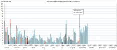
though if you compare with 2009 and 2010 where the X axis is at 350 its about right for revised/reviewed/final data, just sooner then usual.
seabreeze.wordpress.com...
I think the energy released graph will be more stable though ( when I get around to doing Sept.)
M3.5 - 1km N of Belen, New Mexico
2012-09-29 00:59:48 UTC
M4.5 - 54km NW of San Antonio de los Cobres, Argentina
2012-09-29 01:26:
earthquake.usgs.gov...
A little more rocking in the SW.
2012-09-29 00:59:48 UTC
M4.5 - 54km NW of San Antonio de los Cobres, Argentina
2012-09-29 01:26:
earthquake.usgs.gov...
A little more rocking in the SW.
5.8 earthquake, 6km SE of Cuajinicuilapa, Mexico. Sep 29 00:11 at epicenter (depth 22km
2012-09-29 07:11:15 UTC
2012-09-29 00:11:15 UTC-07:00 at epicenter
2012-09-29 03:11:15 UTC-04:00 system time
Location
16.432°N 98.363°W depth=21.7km (13.5mi)
Nearby Cities
6km (4mi) SE of Cuajinicuilapa, Mexico
28km (17mi) SSE of Ometepec, Mexico
39km (24mi) WNW of Santiago Pinotepa Nacional, Mexico
112km (70mi) ESE of San Marcos, Mexico
341km (212mi) SSE of Mexico City, Mexico
4.7 earthquake, 157km E of Chichi-shima, Japan. Sep 29 19:52 at epicenter (depth 10km)
2012-09-29 09:52:49 UTC
2012-09-29 19:52:49 UTC+10:00 at epicenter
2012-09-29 05:52:49 UTC-04:00 system time
Location
26.924°N 143.795°E depth=10.1km (6.3mi)
Nearby Cities
157km (98mi) E of Chichi-shima, Japan
968km (601mi) SSE of Tateyama, Japan
969km (602mi) SSE of Katsuura, Japan
972km (604mi) SSE of Kawaguchi, Japan
1047km (651mi) SSE of Tokyo, Japan
M5.9 - 161km S of Severo-Kuril'sk, Russia
This was an M6.0 and has been reduced for a quick sale.
My listing (produced by QVSData 30 day checker) says:
So The 6.1 on the 8th has gone down 1 point. I must have missed the 6.2. This was last modified according to USGS on the 11th September but it seems I missed it completely. (My excuse is I was bit busy at the time)
Yup it was posted here: www.abovetopsecret.com...
and in the very next post I said I was busy and told BO he had not missed anything. Prophetic really as I had!!
This was an M6.0 and has been reduced for a quick sale.
My listing (produced by QVSData 30 day checker) says:
Downgraded quake
us|c000cmre|?|Sunday, September 09, 2012 05:39:37 UTC|49.251|155.742|5.9|33.3|?|161km S of Severo-Kuril'sk, Russia
Downgraded quake
us|c000cium|?|Saturday, September 08, 2012 10:51:44 UTC|-3.176|135.11|6|21|?|46km WNW of Nabire, Indonesia
Downgraded quake
us|c000ce33|?|Monday, September 03, 2012 18:23:04 UTC|-10.785|113.88|6.2|8.8|?|244km S of Sidorukun, Indonesia
So The 6.1 on the 8th has gone down 1 point. I must have missed the 6.2. This was last modified according to USGS on the 11th September but it seems I missed it completely. (My excuse is I was bit busy at the time)
Yup it was posted here: www.abovetopsecret.com...
and in the very next post I said I was busy and told BO he had not missed anything. Prophetic really as I had!!
edit on 29/9/2012 by PuterMan because: (no reason given)
new topics
-
George Knapp AMA on DI
Area 51 and other Facilities: 5 hours ago -
Not Aliens but a Nazi Occult Inspired and then Science Rendered Design.
Aliens and UFOs: 5 hours ago -
Louisiana Lawmakers Seek to Limit Public Access to Government Records
Political Issues: 7 hours ago -
The Tories may be wiped out after the Election - Serves them Right
Regional Politics: 9 hours ago -
So I saw about 30 UFOs in formation last night.
Aliens and UFOs: 11 hours ago
top topics
-
BREAKING: O’Keefe Media Uncovers who is really running the White House
US Political Madness: 12 hours ago, 25 flags -
George Knapp AMA on DI
Area 51 and other Facilities: 5 hours ago, 19 flags -
Biden--My Uncle Was Eaten By Cannibals
US Political Madness: 13 hours ago, 18 flags -
Louisiana Lawmakers Seek to Limit Public Access to Government Records
Political Issues: 7 hours ago, 7 flags -
"We're All Hamas" Heard at Columbia University Protests
Social Issues and Civil Unrest: 13 hours ago, 7 flags -
Russian intelligence officer: explosions at defense factories in the USA and Wales may be sabotage
Weaponry: 17 hours ago, 6 flags -
So I saw about 30 UFOs in formation last night.
Aliens and UFOs: 11 hours ago, 5 flags -
The Tories may be wiped out after the Election - Serves them Right
Regional Politics: 9 hours ago, 3 flags -
Not Aliens but a Nazi Occult Inspired and then Science Rendered Design.
Aliens and UFOs: 5 hours ago, 3 flags -
Do we live in a simulation similar to The Matrix 1999?
ATS Skunk Works: 12 hours ago, 3 flags
active topics
-
Alabama Man Detonated Explosive Device Outside of the State Attorney General’s Office
Social Issues and Civil Unrest • 58 • : Unknownparadox -
BREAKING: O’Keefe Media Uncovers who is really running the White House
US Political Madness • 13 • : WeMustCare -
Candidate TRUMP Now Has Crazy Judge JUAN MERCHAN After Him - The Stormy Daniels Hush-Money Case.
Political Conspiracies • 385 • : Vermilion -
"We're All Hamas" Heard at Columbia University Protests
Social Issues and Civil Unrest • 127 • : marg6043 -
Two Serious Crimes Committed by President JOE BIDEN that are Easy to Impeach Him For.
US Political Madness • 16 • : WeMustCare -
911 emergency lines are DOWN across multiple states
Breaking Alternative News • 6 • : nugget1 -
Biden--My Uncle Was Eaten By Cannibals
US Political Madness • 46 • : CarlLaFong -
Do we live in a simulation similar to The Matrix 1999?
ATS Skunk Works • 21 • : ByeByeAmericanPie -
Not Aliens but a Nazi Occult Inspired and then Science Rendered Design.
Aliens and UFOs • 8 • : theatreboy -
I Guess Cloud Seeding Works
Fragile Earth • 25 • : Degradation33