It looks like you're using an Ad Blocker.
Please white-list or disable AboveTopSecret.com in your ad-blocking tool.
Thank you.
Some features of ATS will be disabled while you continue to use an ad-blocker.

Track NASA's Falling, 6.5-Ton Satellite In Real-Time
page: 1share:
If you can't get on the N2YO.com satellite tracking site due to overloaded servers, you can track the satellite's progress in realtime using the
applet presented here:
Track NASA's Falling, 6.5-Ton Satellite In Real-Time
www.foxnews.com...
Just thought I'd post FYI.
ETA: Applet is about halfway down the page.
Track NASA's Falling, 6.5-Ton Satellite In Real-Time
www.foxnews.com...
Just thought I'd post FYI.
ETA: Applet is about halfway down the page.
edit on 9/22/2011 by this_is_who_we_are because: ETA
reply to post by this_is_who_we_are
Thank you, saved the link...but it said "server busy try again later"
Thank you, saved the link...but it said "server busy try again later"
reply to post by summer5
Got it. Ya just have to keep hitting refresh.
The map actually shows movement. Cool
But it is showing a pic of the ISS rather than the satellitte.
Got it. Ya just have to keep hitting refresh.
The map actually shows movement. Cool
But it is showing a pic of the ISS rather than the satellitte.
edit on 22-9-2011 by TDawgRex because: (no reason given)
Originally posted by TDawgRex
reply to post by summer5
Got it. Ya just have to keep hitting refresh.
The map actually shows movement. Cool
But it is showing a pic of the ISS rather than the satellitte.edit on 22-9-2011 by TDawgRex because: (no reason given)
I think they use a generic graphic. The path goes nearly over my area in southeastern lower Michigan. Zoinks!
Originally posted by this_is_who_we_are
Originally posted by TDawgRex
reply to post by summer5
Got it. Ya just have to keep hitting refresh.
The map actually shows movement. Cool
But it is showing a pic of the ISS rather than the satellitte.edit on 22-9-2011 by TDawgRex because: (no reason given)
I think they use a generic graphic. The path goes nearly over my area in southeastern lower Michigan. Zoinks!
Nope...just found UARS. The page automatically loads the ISS orbit. You have to click the UARS link. It's almost over South America at the moment.
On one real-time map it's showing going over Europe while another map shows it's over South America; can't be in 2 places at once......
This is a capture moments ago of the applet on the Fox news Site link from my OP:
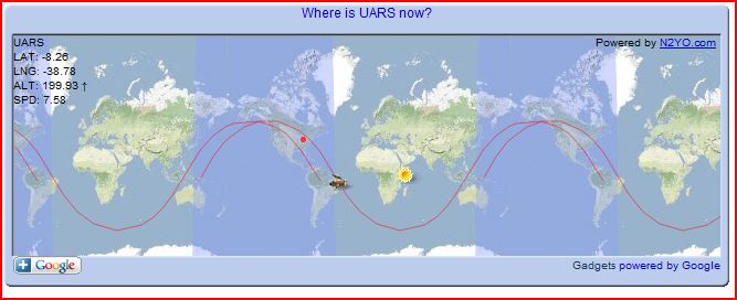
It says it's UARS in the upper left hand corner, above the lat, lng, speed and altitude info.
It says it's UARS in the upper left hand corner, above the lat, lng, speed and altitude info.
edit on 9/22/2011 by this_is_who_we_are because:
typo
I just timed it is taking 40sec to loose 1unit on alt ( I think it;s in miles) the app says there is 190 odd units of alt so this means hit in about
2hrs.
Does this sound right?
EDIT:
Forget that, it's gone up again.
Can someone advise how they calculate the altitude?
IS it to sea level, and the object is actually going up and down in alt or is it taken from ground level, hense the ups and downs?
Or is it relative to the equator eg, does it loose altn closer to the equator, and gain alt as it moves North or South of the equator?
edit on
22-9-2011 by afaik because: (no reason given)
So does it seem like it might hit southeastern Michigan? It's hard to tell from my cell phone.
Originally posted by afaik
I just timed it is taking 40sec to loose 1unit on alt ( I think it;s in miles) the app says there is 190 odd units of alt so this means hit in about 2hrs.
Does this sound right?
EDIT:
Forget that, it's gone up again.
Can someone advise how they calculate the altitude?
IS it to sea level, and the object is actually going up and down in alt or is it taken from ground level, hense the ups and downs?
Or is it relative to the equator eg, does it loose altn closer to the equator, and gain alt as it moves North or South of the equator?edit on 22-9-2011 by afaik because: (no reason given)
Elliptical orbits have a high point ("apogee") and a low point ("perigee"). Atmospheric drag is causing both to become lower with each orbit. The drag increases the lower it goes (as the atmosphere gets thicker). The point-of-no-return will be when it gets so low that drag slows it to the point where it can no-longer rise. Although it will be too slow to stay in orbit, it will still be moving at over Mach 20 as it descends into the upper atmosphere. The pressure from such high-speed travel will start to tear it apart. Heat from friction and the air compressing in front of it will quickly build up past the melting -and even the vaporization point - of aluminum.
Whoosh - poof! The End.
Originally posted by this_is_who_we_are
If you can't get on the N2YO.com satellite tracking site due to overloaded servers, you can track the satellite's progress in realtime using the applet presented here:
Track NASA's Falling, 6.5-Ton Satellite In Real-Time
www.foxnews.com...
Just thought I'd post FYI.
ETA: Applet is about halfway down the page.edit on 9/22/2011 by this_is_who_we_are because: ETA
I appreciate this link more then I can express I have been searching for somethign like this for a few days...S&F peace.
NASA is posting updates on the progress of UARS as well. Might want to keep an eye on that too.
www.nasa.gov...
And, there's always twitter.
twitter.com...
No luck finding a tracker that works.
www.nasa.gov...
And, there's always twitter.
twitter.com...
No luck finding a tracker that works.
The tracker at the site I posted loads very very slowly. I suppose there are about a million people trying to get that page to load. Sorry.
news.sky.com...
Something to do with cosmic disturbances is making it come down sooner than expected.
Nasa Satellite 'To Hit Earth Within Hours'
...the size of a double-decker bus.
...He says the tumbling probe is causing tracking difficulty because of its shape, size and speed.
"There's a great deal of uncertainty over where it will re-enter. Due to the irregular size and shape of this object it's impossible to say.
"These things move at about 7.5 kilometres (4.6 miles) per second in space and something moving at that speed is very difficult to predict....
Scientists expect up to 26 pieces - with a combined mass of about 540kg - to survive the fiery re-entry.
Something to do with cosmic disturbances is making it come down sooner than expected.
Originally posted by wrathofall
So does it seem like it might hit southeastern Michigan? It's hard to tell from my cell phone.
That is not cool....That is where I live.....seriously not cool at all.
unless of course it lands where nobody lives and I get to see it.
Anybody know what time it is supposed to be visible ?
Originally posted by Phage
Latest update holding with Friday afternoon.
Update #9
Thu, 22 Sep 2011 04:01:35 PM GMT-1000
As of 9:30 p.m. EDT Sept. 22, 2011, the orbit of UARS was 110 mi by 115 mi (175 km by 185 km). Re-entry is possible sometime during the afternoon or early evening of Sept. 23, Eastern Daylight Time. The satellite will not be passing over North America during that time period. It is still too early to predict the time and location of re-entry with any more certainty, but predictions will become more refined in the next 24 hours.
www.nasa.gov...
Here's a tracker that loads relatively quickly (considering)
www.infosatellites.com...
Thanks to Versa the link here:
www.abovetopsecret.com...
www.infosatellites.com...
Thanks to Versa the link here:
www.abovetopsecret.com...
new topics
-
Big Storms
Fragile Earth: 1 hours ago -
Where should Trump hold his next rally
2024 Elections: 3 hours ago -
Shocking Number of Voters are Open to Committing Election Fraud
US Political Madness: 4 hours ago -
Gov Kristi Noem Shot and Killed "Less Than Worthless Dog" and a 'Smelly Goat
2024 Elections: 5 hours ago -
Falkville Robot-Man
Aliens and UFOs: 5 hours ago -
James O’Keefe: I have evidence that exposes the CIA, and it’s on camera.
Whistle Blowers and Leaked Documents: 6 hours ago -
Australian PM says the quiet part out loud - "free speech is a threat to democratic dicourse"...?!
New World Order: 6 hours ago -
Ireland VS Globalists
Social Issues and Civil Unrest: 7 hours ago -
Biden "Happy To Debate Trump"
2024 Elections: 8 hours ago -
RAAF airbase in Roswell, New Mexico is on fire
Aliens and UFOs: 8 hours ago
top topics
-
A Warning to America: 25 Ways the US is Being Destroyed
New World Order: 17 hours ago, 21 flags -
Blast from the past: ATS Review Podcast, 2006: With All Three Amigos
Member PODcasts: 10 hours ago, 13 flags -
James O’Keefe: I have evidence that exposes the CIA, and it’s on camera.
Whistle Blowers and Leaked Documents: 6 hours ago, 13 flags -
Biden "Happy To Debate Trump"
2024 Elections: 8 hours ago, 12 flags -
Australian PM says the quiet part out loud - "free speech is a threat to democratic dicourse"...?!
New World Order: 6 hours ago, 12 flags -
Mike Pinder The Moody Blues R.I.P.
Music: 10 hours ago, 8 flags -
What is the white pill?
Philosophy and Metaphysics: 9 hours ago, 6 flags -
Shocking Number of Voters are Open to Committing Election Fraud
US Political Madness: 4 hours ago, 5 flags -
Ireland VS Globalists
Social Issues and Civil Unrest: 7 hours ago, 5 flags -
RAAF airbase in Roswell, New Mexico is on fire
Aliens and UFOs: 8 hours ago, 5 flags
active topics
-
Definitive 9.11 Pentagon EVIDENCE.
9/11 Conspiracies • 427 • : Zanti Misfit -
So this is what Hamas considers 'freedom fighting' ...
War On Terrorism • 266 • : ToneD -
Big Storms
Fragile Earth • 8 • : charlest2 -
SHORT STORY WRITERS CONTEST -- April 2024 -- TIME -- TIME2024
Short Stories • 24 • : argentus -
Gov Kristi Noem Shot and Killed "Less Than Worthless Dog" and a 'Smelly Goat
2024 Elections • 35 • : nugget1 -
Ireland VS Globalists
Social Issues and Civil Unrest • 7 • : boatguy12 -
"We're All Hamas" Heard at Columbia University Protests
Social Issues and Civil Unrest • 292 • : TheWoker -
I am beholden to my truth, of which I share with you now.
Dreams & Predictions • 24 • : BrotherKinsMan -
Starburst galaxy M82 - Webb Vs Hubble
Space Exploration • 11 • : Arbitrageur -
Candidate TRUMP Now Has Crazy Judge JUAN MERCHAN After Him - The Stormy Daniels Hush-Money Case.
Political Conspiracies • 817 • : RazorV66