It looks like you're using an Ad Blocker.
Please white-list or disable AboveTopSecret.com in your ad-blocking tool.
Thank you.
Some features of ATS will be disabled while you continue to use an ad-blocker.

Quake Watch 2011
page: 399share:
Rather large quake in the Aegean.
Magnitude ML 4.5
Region AEGEAN SEA
Date time 2011-12-12 22:48:11.0 UTC
Location 38.97 N ; 24.36 E
Depth 10 km
Distances 120 km NE Peristérion (pop 137,659 ; local time 00:48:11.0 2011-12-13)
87 km NE Khalkís (pop 54,558 ; local time 00:48:11.0 2011-12-13)
19 km NW Skíros (pop 1,732 ; local time 00:48:11.0 2011-12-13)
Source parameters provided by another agency
Greetings from Japan:
Just what fukushima needs...
USGS
Earthquake Details
This event has been reviewed by a seismologist.
Magnitude 5.0
Date-Time Tuesday, December 13, 2011 at 00:57:12 UTC Tuesday, December 13, 2011 at 10:57:12AM at epicenter Time of Earthquakein otherTimeZones
Location 37.764°N, 143.584°E
Depth 35.3 km (21.9 miles)
Region OFF THE EAST COAST OF HONSHU, JAPAN
Distances 242 km (150 miles) ESE of Sendai, Honshu, Japan 251 km (155 miles) ENE of Iwaki, Honshu, Japan 274 km (170 miles) E of Fukushima, Honshu, Japan 412 km (256 miles) NE of TOKYO, Japan
Location Uncertainty horizontal+/- 21.5 km (13.4 miles);depth +/- 5.5km (3.4miles)
Parameters NST= 44, Nph= 45, Dmin=474.2 km, Rmss=0.79 sec, Gp=133°, M-type=body wave magnitude (Mb), Version=5
Source Magnitude: USGSNEIC (WDCS-D) Location: USGSNEIC (WDCS-D)
Event ID usc00075tw
Just what fukushima needs...
USGS
For the early birds...the following
Magnitude Mw 5.4
Region SOUTH OF PANAMA
Date time 2011-12-13 07:28:12.0 UTC
Location 4.79 N ; 82.61 W
Depth 10 km
Distances 576 km SW Panamá (pop 408,168 ; local time 02:28:12.0 2011-12-13)
389 km S Puerto armuelles (pop 18,795 ; local time 02:28:12.0 2011-12-13)
361 km S Burica (pop 1,360 ; local time 02:28:12.0 2011-12-13)
Source parameters reviewed by a seismologist
Magnitude mb 5.1
Region NORTHERN MID-ATLANTIC RIDGE
Date time 2011-12-13 07:28:57.0 UTC
Location 28.68 N ; 43.89 W
Depth 10 km
Distances 2234 km SE Saint john's (pop 112,007 ; local time 03:58:57.6 2011-12-13)
1895 km SW Angra (pop 12,045 ; local time 06:28:57.6 2011-12-13)
1779 km SW Ribeira grande (pop 5,198 ; local time 06:28:57.6 2011-12-13)
Magnitude Mw 6.1
Region MINAHASA, SULAWESI, INDONESIA
Date time 2011-12-13 07:52:12.0 UTC
Location 0.03 N ; 123.13 E
Depth 165 km
Distances 59 km S Gorontalo (pop 144,195 ; local time 15:52:12.5 2011-12-13)
103 km SW Mobagu (pop 82,137 ; local time 15:52:12.5 2011-12-13)
Source: EMSC
Rainbows
Jane
www.nytimes.com...
www.wfmj.com...
www.nature.com...
www.npr.org...
Yellowstone has been interesting to watch. They've add a few of those missing quakes.
www.quake.utah.edu...
After midnight, I will miss watching Yellowstone. I'll be long gone on a 2000km trip on rail in the middle of nowhere. So, I'll be disconnected. I hope somone keeps track of the big boy, cause you never know.
Keep watching.
Magnitude
6.0
Date-Time
Tuesday, December 13, 2011 at 07:52:11 UTC
Tuesday, December 13, 2011 at 03:52:11 PM at epicenter
Time of Earthquake in other Time Zones
Location
0.010°N, 123.027°E
Depth
156.1 km (97.0 miles)
Region
MINAHASA, SULAWESI, INDONESIA
Distances
68 km (42 miles) S of Gorontalo, Sulawesi, Indonesia
260 km (161 miles) SW of Manado, Sulawesi, Indonesia
978 km (607 miles) NNW of DILI, Timor-Leste
1615 km (1003 miles) NNW of DARWIN, Northern Territory, Australia
Location Uncertainty
horizontal +/- 12.4 km (7.7 miles); depth +/- 2.6 km (1.6 miles)
Parameters
NST=607, Nph=657, Dmin=120.2 km, Rmss=0.83 sec, Gp= 14°,
M-type="moment" magnitude from initial P wave (tsuboi method) (Mi/Mwp), Version=B
Source
Magnitude: USGS NEIC (WDCS-D)
Location: USGS NEIC (WDCS-D)
Event ID
usc00075ux/ex]
earthquake.usgs.gov...
EMSC
Magnitude M 4.7
Region VIRGIN ISLANDS REGION
Date time 2011-12-13 22:04:35.0 UTC
Location 19.46 N ; 64.42 W
Depth 39 km
4.1 Reports USGS.
Edit: Another near subduction.
USGS
Magnitude 3.9
Region - NORTH OF THE VIRGIN ISLANDS
Date-Time - Tuesday, December 13, 2011 at 07:07:55 PM
Location
19.872°N, 63.732°W
Depth
49 km (30.4 miles)
edit on 13/12/11 by murkraz because: update
Tonga checking in
Magnitude mb 5.1
Region TONGA
Date time 2011-12-14 00:48:17.0 UTC
Location 15.34 S ; 174.85 W
Depth 60 km
Distances 780 km E Suva (pop 199,455 ; local time 12:48:17.0 2011-12-14)
372 km SW Apia (pop 40,407 ; local time 13:48:17.0 2011-12-13)
136 km NW Hihifo (pop 815 ; local time 14:48:17.0 2011-12-14)
www.emsc-csem.org...
Rainbows
Jane
reply to post by ericblair4891
Hmmmm......you're going 2000 km away into the boondocks, & someone should keep an eye on YS.
Coming from anyone else I'd be worried that was very vaguely veiled 'bug out' code! Ha, ha!
I have the Yellowstone seismo link on my favorites bar, but can't pull it up, something is wrong with it.
I'll find another link & promise to check it everyday.
Hope this is a pleasure trip.You deserve a break! If you are going to be in the boonies, I hope you can immerse yourself in nature, enjoy being away & return home rejuvenated! I'm really jealous. Wish I could do that! How often I've wished I had been born in a simpler time! Just being able to get out into the woods for a few hours, away from everything, gives me a whole new perspective.
Awhile back I posted a want ad for a cave. Don't know if you happened to see it, how about keeping an eye open in case you run across one!
Don't worry about anything while you are away, we'll hold down the fort! Not as well as you do, but we'll do our best!
Take care.
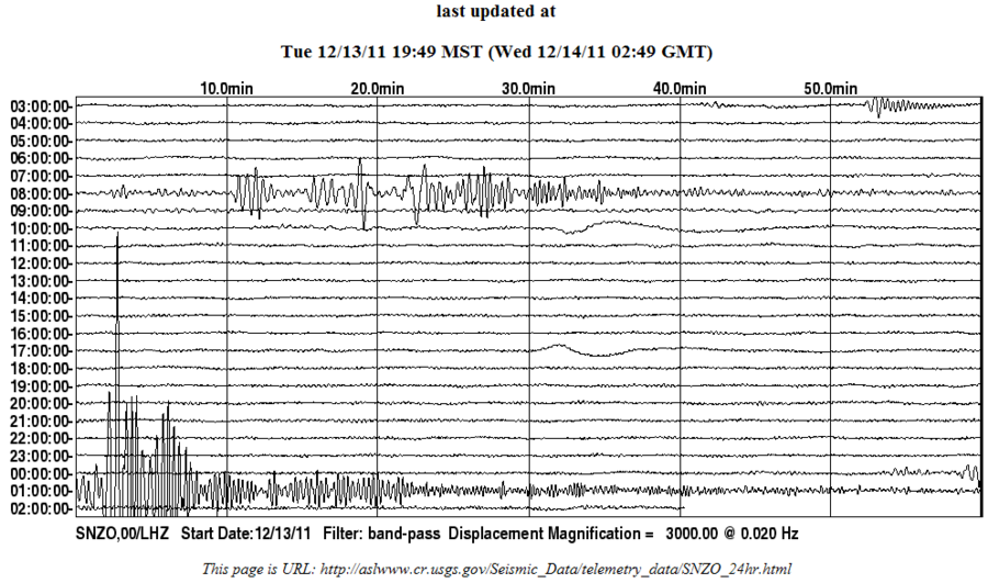
another take on Tonga
GeoAu version
USGS version
not that big but it left a pretty big trace on SNZO considering it was 3000 km away

Also something a bit closer
was 17.66km south-east of me, on the Paekakariki Hill Rd, but I didn't feel it
Geonet page
and something a bit unusual yesterday, east of Wellington, between the Chatham Is and th North Is.
you do get the odd one on the Chatham Rise but not usually so far north out on the flat Pacific Plate.
MAG, REF, LAT, LONG, UTC, DEPTH
4.149ML, 3626213, -41.9632, -179.9922, 2011/ 12/13 06:29:18, 33km
source
GMap of location
Tonga Islands, Kermadec - Tonga - Samoa Area.
Magnitude: 5.2 (Mb)
Depth: 0 km
Tsunamigenic: Not available
Date and Time
UTC: 14 December 2011 @ 00:48:09
Location
Coordinates: -15.351, -174.521
Solution status
Last updated: 14 December 2011 @ 13:29:52 (AEST)
Solution finalised: No
Source: AUST
GeoAu version
USGS version
not that big but it left a pretty big trace on SNZO considering it was 3000 km away
Also something a bit closer
was 17.66km south-east of me, on the Paekakariki Hill Rd, but I didn't feel it
Reference Number 3626643
Universal Time December 14 2011 at 1:41
NZ Daylight Time Wednesday, December 14 2011 at 2:41 pm
Latitude, Longitude -41.06443, 174.93062
Focal Depth 35 km
Richter magnitude 3.2
Region Wellington
Location
10 km north-east of Porirua
10 km north-west of Upper Hutt
20 km south of Paraparaumu
30 km north-east of Wellington
Geonet page
and something a bit unusual yesterday, east of Wellington, between the Chatham Is and th North Is.
you do get the odd one on the Chatham Rise but not usually so far north out on the flat Pacific Plate.
MAG, REF, LAT, LONG, UTC, DEPTH
4.149ML, 3626213, -41.9632, -179.9922, 2011/ 12/13 06:29:18, 33km
source
GMap of location
edit on 13-12-2011 by muzzy because: (no reason given)
7.3 Papua New Guinea
Wednesday, December 14, 2011 at 05:04:58 UTC
Wednesday, December 14, 2011 at 03:04:58 PM at epicenter
Depth 115km
earthquake.usgs.gov...
87 km (54 miles) SSW (197°) from Lae, New Guinea, PNG
123 km (76 miles) ENE (64°) from Kerema, New Guinea, PNG
214 km (133 miles) NW (310°) from Popondetta, New Guinea, PNG
224 km (139 miles) NNW (348°) from PORT MORESBY, Papua New Guinea
edit on 13-12-2011 by MoorfNZ because: (no reason given)
Wonder if those quakes are going to trigger Koranga Vulcano. It's only around 23 kilometers away from the epicenter.
Originally posted by MoorfNZ
7.3 Papua New Guinea
Wednesday, December 14, 2011 at 05:04:58 UTC
Wednesday, December 14, 2011 at 03:04:58 PM at epicenter
Depth 115km
earthquake.usgs.gov...
87 km (54 miles) SSW (197°) from Lae, New Guinea, PNG
123 km (76 miles) ENE (64°) from Kerema, New Guinea, PNG
214 km (133 miles) NW (310°) from Popondetta, New Guinea, PNG
224 km (139 miles) NNW (348°) from PORT MORESBY, Papua New Guineaedit on 13-12-2011 by MoorfNZ because: (no reason given)
seems like something is about to crack.. its that time of the year when things start really shaking.. remember Indonesia ?
reply to post by kassych
Japan wasn't at this time of year, neither was Canterbury 7.1... and there's no correlation with end of the year where the largest quakes are concerned either. earthquake.usgs.gov...
Japan wasn't at this time of year, neither was Canterbury 7.1... and there's no correlation with end of the year where the largest quakes are concerned either. earthquake.usgs.gov...
reply to post by murkraz
???? What do you think all those dots are?! It's a highly seismic area,,...
The star represents today's event..
???? What do you think all those dots are?! It's a highly seismic area,,...
The star represents today's event..
edit on 13-12-2011 by MoorfNZ because: (no reason given)
I think that 7.1 will drop down below 7.0 eventually.
If you look at the closest LISS station PMG graph the trace is not that big really
and the USGS phase data has a hang of a lot of magnitude 6 readings on it.
note mb = 6.6 (256) ML = 6.7 ( 4)
also note in the details "M-type="moment" magnitude from initial P wave (tsuboi method) (Mi/Mwp), Version=9"
from memory the tsuboi method usually get replaced with something more reliable later
How about 6.9Mw
or maybe not
just checked with the russians they have 7.1mb which theoretically should translate to about 7.4 Ms
If you look at the closest LISS station PMG graph the trace is not that big really
and the USGS phase data has a hang of a lot of magnitude 6 readings on it.
note mb = 6.6 (256) ML = 6.7 ( 4)
also note in the details "M-type="moment" magnitude from initial P wave (tsuboi method) (Mi/Mwp), Version=9"
from memory the tsuboi method usually get replaced with something more reliable later
How about 6.9Mw
edit on 14-12-2011 by muzzy because: (no reason given)
or maybe not
just checked with the russians they have 7.1mb which theoretically should translate to about 7.4 Ms
edit on 14-12-2011 by muzzy because: (no reason given)
Originally posted by MoorfNZ
reply to post by murkraz
???? What do you think all those dots are?! It's a highly seismic area,,...
The star represents today's event..edit on 13-12-2011 by MoorfNZ because: (no reason given)
I was reading it as in... the red dots, can't see any on land or are they just covered by the sheer mass of general activity?
Edit: Nevermind I'm an idiot. Haven't delved into the historic visuals before really.
edit on 14/12/11 by murkraz because: (no reason
given)
new topics
-
BIDEN Admin Begins Planning For January 2025 Transition to a New President - Today is 4.26.2024.
2024 Elections: 1 hours ago -
Big Storms
Fragile Earth: 3 hours ago -
Where should Trump hold his next rally
2024 Elections: 5 hours ago -
Shocking Number of Voters are Open to Committing Election Fraud
US Political Madness: 6 hours ago -
Gov Kristi Noem Shot and Killed "Less Than Worthless Dog" and a 'Smelly Goat
2024 Elections: 7 hours ago -
Falkville Robot-Man
Aliens and UFOs: 7 hours ago -
James O’Keefe: I have evidence that exposes the CIA, and it’s on camera.
Whistle Blowers and Leaked Documents: 8 hours ago -
Australian PM says the quiet part out loud - "free speech is a threat to democratic dicourse"...?!
New World Order: 8 hours ago -
Ireland VS Globalists
Social Issues and Civil Unrest: 9 hours ago -
Biden "Happy To Debate Trump"
2024 Elections: 9 hours ago
top topics
-
James O’Keefe: I have evidence that exposes the CIA, and it’s on camera.
Whistle Blowers and Leaked Documents: 8 hours ago, 14 flags -
Australian PM says the quiet part out loud - "free speech is a threat to democratic dicourse"...?!
New World Order: 8 hours ago, 13 flags -
Blast from the past: ATS Review Podcast, 2006: With All Three Amigos
Member PODcasts: 12 hours ago, 13 flags -
Biden "Happy To Debate Trump"
2024 Elections: 9 hours ago, 12 flags -
Mike Pinder The Moody Blues R.I.P.
Music: 12 hours ago, 8 flags -
What is the white pill?
Philosophy and Metaphysics: 11 hours ago, 6 flags -
Shocking Number of Voters are Open to Committing Election Fraud
US Political Madness: 6 hours ago, 6 flags -
RAAF airbase in Roswell, New Mexico is on fire
Aliens and UFOs: 10 hours ago, 5 flags -
Ireland VS Globalists
Social Issues and Civil Unrest: 9 hours ago, 5 flags -
Where should Trump hold his next rally
2024 Elections: 5 hours ago, 5 flags
active topics
-
Big Storms
Fragile Earth • 12 • : Lumenari -
Gov Kristi Noem Shot and Killed "Less Than Worthless Dog" and a 'Smelly Goat
2024 Elections • 47 • : cherokeetroy -
BIDEN Admin Begins Planning For January 2025 Transition to a New President - Today is 4.26.2024.
2024 Elections • 8 • : NoCorruptionAllowed -
ALERT - U.S. President JOE BIDEN Examined and Found NOT OF SOUND MIND.
2024 Elections • 65 • : SchrodingersRat -
James O’Keefe: I have evidence that exposes the CIA, and it’s on camera.
Whistle Blowers and Leaked Documents • 13 • : theatreboy -
Where should Trump hold his next rally
2024 Elections • 21 • : Dandandat3 -
RAAF airbase in Roswell, New Mexico is on fire
Aliens and UFOs • 9 • : Degradation33 -
President BIDEN's FBI Raided Donald Trump's Florida Home for OBAMA-NORTH KOREA Documents.
Political Conspiracies • 38 • : SchrodingersRat -
Joe Biden and Donald Trump are both traitors
2024 Elections • 65 • : MrMez -
Mood Music Part VI
Music • 3112 • : underpass61