It looks like you're using an Ad Blocker.
Please white-list or disable AboveTopSecret.com in your ad-blocking tool.
Thank you.
Some features of ATS will be disabled while you continue to use an ad-blocker.

Quake Watch 2011
page: 297share:
reply to post by radpetey
That represents the sub-solar point. If you watch throughout the day it will move as the earth rotates and brings a different part "under" the sun...
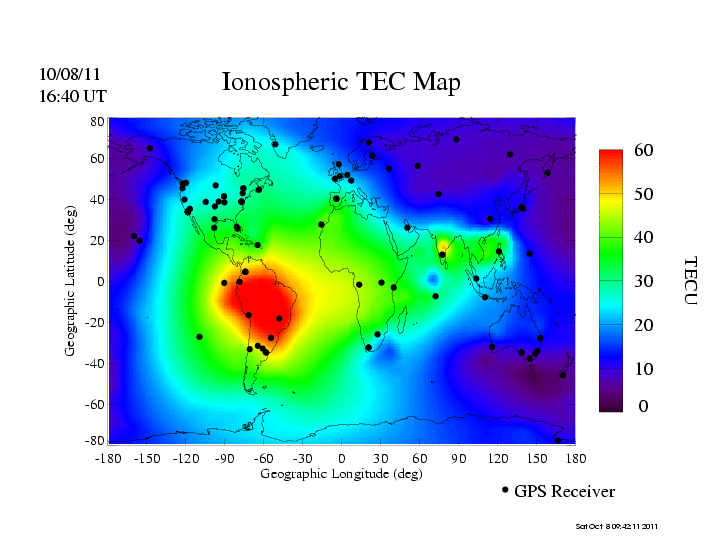
I am more interested in the anomalous "hot spot" in India...
That represents the sub-solar point. If you watch throughout the day it will move as the earth rotates and brings a different part "under" the sun...
I am more interested in the anomalous "hot spot" in India...
edit on 8-10-2011 by jadedANDcynical because: minor typos
reply to post by jadedANDcynical
Oops.......my bad.
I guess ignorance is NOT bliss on ATS. Thank you for the correction.
However the blip in India is a little concerning!
Oops.......my bad.
I guess ignorance is NOT bliss on ATS. Thank you for the correction.
However the blip in India is a little concerning!
reply to post by radpetey
Here we see that the spot over India has cooled off:
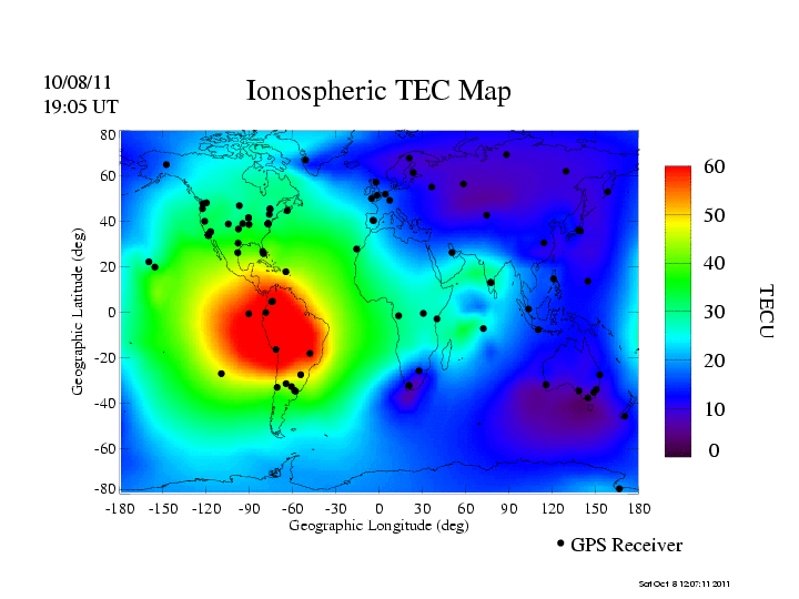
It is still a bit higher than the ambient for it's surrounding area, but it is no longer much higher than it's surroundings.
Oddness for certain. Be interesting to see if this occurs again.
Here we see that the spot over India has cooled off:
It is still a bit higher than the ambient for it's surrounding area, but it is no longer much higher than it's surroundings.
Oddness for certain. Be interesting to see if this occurs again.
Magnitude
3.1
Date-Time
Saturday, October 08, 2011 at 18:55:21 UTC
Saturday, October 08, 2011 at 11:55:21 AM at epicenter
Location
35.492°N, 118.391°W
Depth
4 km (2.5 miles)
Region
CENTRAL CALIFORNIA
Distances
17 km (11 miles) SSE (157°) from town of Lake Isabella, CA
17 km (11 miles) SSW (197°) from Weldon, CA
27 km (17 miles) SW (216°) from Onyx, CA
60 km (37 miles) ENE (75°) from Bakersfield, CA
160 km (100 miles) N (355°) from Los Angeles Civic Center, CA
Location Uncertainty
horizontal +/- 0.3 km (0.2 miles); depth +/- 1 km (0.6 miles)
Parameters
Nph= 69, Dmin=20 km, Rmss=0.29 sec, Gp= 47°,
M-type=local magnitude (ML), Version=0
Source
California Integrated Seismic Net:
USGS Caltech CGS UCB UCSD UNR
Event ID
ci15060820
earthquake.usgs.gov...
3rd mag 5 in 4 days in the North Island , 2nd in the Bay of Plenty in 4 days
throw in the S of Kermy 6.1 and the Banks Pen 4.8 yesterday, methinks the Pacific Plate is on the move
www.geonet.org.nz...
throw in the S of Kermy 6.1 and the Banks Pen 4.8 yesterday, methinks the Pacific Plate is on the move
Reference Number 3591728
Universal Time October 8 2011 at 18:07
NZ Daylight Time Sunday, October 9 2011 at 7:07 am
Latitude, Longitude 37.80°S, 177.57°E
Focal Depth 50 km
Richter magnitude 5.2
Region Bay of Plenty
Location
10 km south-west of Te Kaha
30 km north-east of Opotiki
50 km east of Whakatane
270 km south-east of Auckland
www.geonet.org.nz...
edit on 8-10-2011 by muzzy because: (no reason given)
edit on 8-10-2011 by muzzy because: can't count, was 4 days not
3
reply to post by jadedANDcynical
the sooner it gets over NZ the better
when it showed the purple patch over NZ at 1640 UTC it was only 3 Celcius here (heaters on)
I'll check back on that link around Noon NZDT, hopefully we'll get a bit of the green edge over us at least
the sooner it gets over NZ the better
when it showed the purple patch over NZ at 1640 UTC it was only 3 Celcius here (heaters on)
I'll check back on that link around Noon NZDT, hopefully we'll get a bit of the green edge over us at least
edit on 8-10-2011 by muzzy
because: (no reason given)
reply to post by jadedANDcynical
And now there is a spot (let's not call it hot please as this has nothing to do with heat as such) in South America.
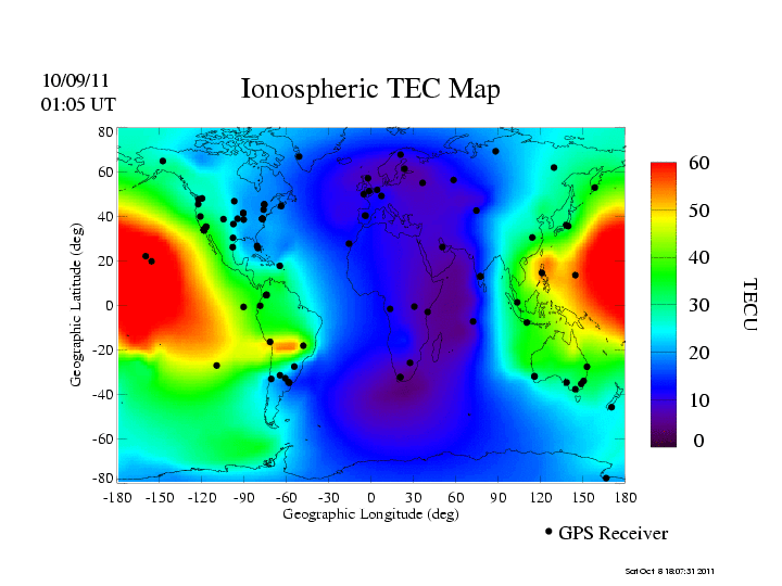
But has anyone noticed that this electron content is remaining high and only dissipating slowly right over the area of the Jujuy earthquakes. Coincidence?
ETA: No quakes in India. One coming perhaps?
And now there is a spot (let's not call it hot please as this has nothing to do with heat as such) in South America.
But has anyone noticed that this electron content is remaining high and only dissipating slowly right over the area of the Jujuy earthquakes. Coincidence?
ETA: No quakes in India. One coming perhaps?
edit on 8/10/2011 by PuterMan because: (no reason given)
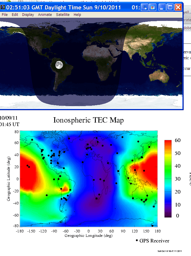
Look what is hanging around where the high electron content is remaining.
Coincidence?
Coincidence?
Puterman - we know the moon as an effect on the ionosphere.. are you saying those images are showing that effect (in laymans terms please - it's
Sunday, it's Bathurst race and I've had a beer or two ) or that that effect can be used to predict quakes.. isn't that what Twinsat is off to do?
reply to post by PuterMan
probably just coincidence.
Wheres the residual high TECU (whatever that is) over the Kermadec Islands? (same size quake as Jujuy) and over Tonga 5.9 which are more recent?.
The latest image at 3:10UTC the residual red spot north into Brazil
probably just coincidence.
Wheres the residual high TECU (whatever that is) over the Kermadec Islands? (same size quake as Jujuy) and over Tonga 5.9 which are more recent?.
The latest image at 3:10UTC the residual red spot north into Brazil
edit on 8-10-2011 by muzzy because: (no reason given)
MAP 2.0 2011/10/09 11:27:28 35.538 -92.297 5.1 8 km ( 5 mi) SSW of Fairfield Bay, AR
And those that made a bid on Colorado, it showed up, just late.
MAP 2.8 2011/10/09 05:44:50 37.084 -104.995 5.0 34 km ( 21 mi) W of Cokedale, CO
And those that made a bid on Colorado, it showed up, just late.
MAP 2.8 2011/10/09 05:44:50 37.084 -104.995 5.0 34 km ( 21 mi) W of Cokedale, CO
edit on 9-10-2011 by Robin Marks because: (no reason given)
reply to post by MoorfNZ
No, it was late and I was just thinking out loud. It is probably as muzzy says just coincidence as most things are.
Deflation at Katla today. Must be the wind and rain. Incessant it is here for days and days now. I wish Texas would come and collect some of it.
GOLA GPS plot
reply to post by muzzy
Total
Electron
Content
Units
I believe.
No, it was late and I was just thinking out loud. It is probably as muzzy says just coincidence as most things are.
Deflation at Katla today. Must be the wind and rain. Incessant it is here for days and days now. I wish Texas would come and collect some of it.
GOLA GPS plot
reply to post by muzzy
TECU (whatever that is)
Total
Electron
Content
Units
I believe.
edit on 9/10/2011 by PuterMan because: (no reason given)
reply to post by PuterMan
What about this one???
earthquake.usgs.gov...
What about this one???
This event has been reviewed by a seismologist.
Magnitude
5.0
Date-Time
Sunday, October 09, 2011 at 14:47:18 UTC
Sunday, October 09, 2011 at 05:47:18 PM at epicenter
Time of Earthquake in other Time Zones
Location
26.973°S, 38.602°E
Depth
14.7 km (9.1 miles)
Region
SOUTH INDIAN OCEAN
Distances
472 km (293 miles) SE of Inhambane, Mozambique
609 km (378 miles) ESE of MAPUTO, Mozambique
649 km (403 miles) SW of Toliara, Madagascar
807 km (501 miles) ENE of Durban, South Africa
Location Uncertainty
horizontal +/- 18.7 km (11.6 miles); depth +/- 6.4 km (4.0 miles)
Parameters
NST= 41, Nph= 41, Dmin=868.3 km, Rmss=0.52 sec, Gp= 54°,
M-type=body wave magnitude (Mb), Version=5
Source
Magnitude: USGS NEIC (WDCS-D)
Location: USGS NEIC (WDCS-D)
Event ID
usc00066pl
earthquake.usgs.gov...
edit on 9/10/11 by boo1981 because: add text
Bet this was a bit unsettling for MoorfNZ, Aoraki and Co. last night, just when things seemed to be settling down to just one or two Mag 2's a day
MM8- Heavily Damaging at Kaiapoi www.geonet.org.nz...
USGS had it at 4.7mb, 4.9ML
Reference Number 3591999
Universal Time October 9 2011 at 7:34
NZ Daylight Time Sunday, October 9 2011 at 8:34 pm
Latitude, Longitude 43.58°S, 172.82°E
Focal Depth 12 km
Richter magnitude 5.452ML
Region Canterbury
Location
10 km north-east of Diamond Harbour
10 km east of Lyttelton
20 km east of Christchurch
Strongly felt in Chrischurch area, widely felt in Canterbury
MM8- Heavily Damaging at Kaiapoi www.geonet.org.nz...
USGS had it at 4.7mb, 4.9ML
Well I think it is time I put the program out there again seeing as it has taken me 2 years nearly to fiddle about with it. There is still more to do
but if you want to try it you can download it from the QVS Web
site
My apologies to Linux and Mac users, this is only for Windows but maybe one day I can afford to get it converted to Java so it will run on anything. Linux users can run it in WINE but I have no idea if Mac users can run Windows programs I am afraid.
Oh yes, it downloads USGS, EMSC and GeoNet data. It has access to all the real-time seismos and LISS stations and of course can create the sound files if you have the SAC data.
It is free and beta and probably wobbly but let me know any problems. The alerts module currently can only be run from the program directory, basically because it is only used when the service is running. I will set up the means to install it from inside the data centre later.
Help pages are slowly becoming available. qvsdata.wordpress.com...
If you are using dial up do NOT install the services. You need a 1048 screen by the way. You can just about see it on 800 wide but it is not good and not designed for that small a resolution.
Don't know if this has already been reported, but UK keeps dipping its toe in the foray
2011/10/04 08:15:28.7 56.228 -3.577 8 1.4 GLENDEVON,PERTHSHIRE
2011/10/03 21:12:37.7 56.227 -3.575 7 1.6 2 GLENDEVON,PERTHSHIRE FELT CARNBO
Rainbows
Jane
2011/10/04 08:15:28.7 56.228 -3.577 8 1.4 GLENDEVON,PERTHSHIRE
2011/10/03 21:12:37.7 56.227 -3.575 7 1.6 2 GLENDEVON,PERTHSHIRE FELT CARNBO
Rainbows
Jane
PuterMan....WAKE UP!
What's you opinion of what's happening at El Hierro?
earthquake-report.com...
Apparently the 4.4 yesterday triggered a few landslides which took out a couple of roads, on land I hasten to add, unless of course they haven't located any out at sea as of yet.
It would seem that Erik Klementi et all over at eruptions (he has moved site and his new blogg is a horrible site to navigate) are keeping an eye as I type this.
www.wired.com...
You have to use the drop down menue to see the latest postings, and each time you refresh
Rainbows
Jane
edit on 10-10-2011 by angelchemuel because: spelling
Here is a cam link....I have no idea if it is a 'live' feed as I don't speak Spanish. But you can 'twizzle' it about!
www.canarias360.com...
Rainbows
Jane
www.canarias360.com...
Rainbows
Jane
No earthquake in last 11 hours ..
No releases, pressure grows ..
Don't looks good on this graph ..
www.ign.es...
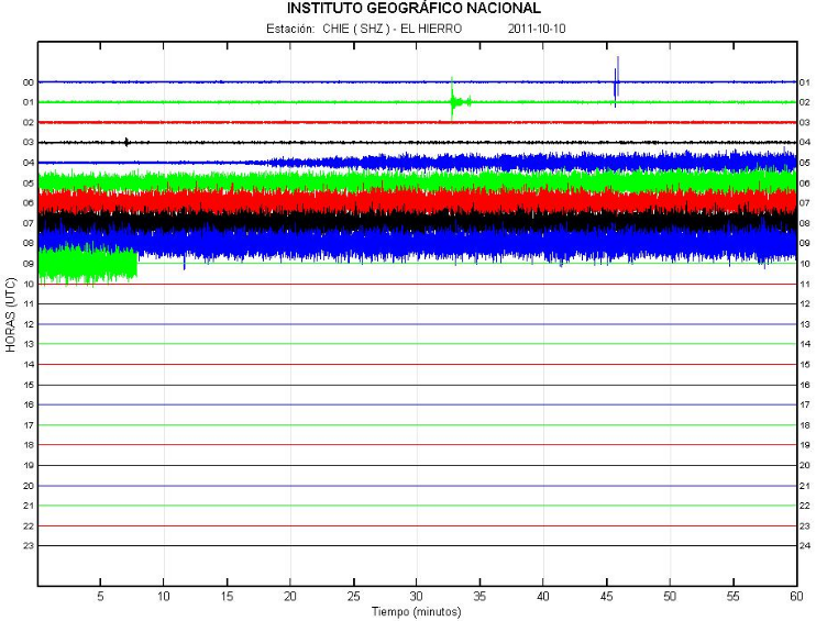
www.01.ign.es...
www.01.ign.es...
earthquake-report.com...
No releases, pressure grows ..
Don't looks good on this graph ..
www.ign.es...
www.01.ign.es...
www.01.ign.es...
earthquake-report.com...
edit on 10-10-2011 by Dalke07
because: (no reason given)
reply to post by Dalke07
That looks like HT. Has it erupted?
Mm, not looking so like HT in the spectrum view
=================
Lots of crashes if you try and use the help in the QVS Data program. Most fixed now along with the illegible service status.
qvsdata.wordpress.com...
That looks like HT. Has it erupted?
Mm, not looking so like HT in the spectrum view
=================
Lots of crashes if you try and use the help in the QVS Data program. Most fixed now along with the illegible service status.
qvsdata.wordpress.com...
edit on 10/10/2011 by PuterMan because: (no reason given)
new topics
-
A Warning to America: 25 Ways the US is Being Destroyed
New World Order: 3 hours ago -
President BIDEN's FBI Raided Donald Trump's Florida Home for OBAMA-NORTH KOREA Documents.
Political Conspiracies: 8 hours ago -
Maestro Benedetto
Literature: 10 hours ago -
Is AI Better Than the Hollywood Elite?
Movies: 10 hours ago
top topics
-
President BIDEN's FBI Raided Donald Trump's Florida Home for OBAMA-NORTH KOREA Documents.
Political Conspiracies: 8 hours ago, 28 flags -
Gaza Terrorists Attack US Humanitarian Pier During Construction
Middle East Issues: 15 hours ago, 8 flags -
Massachusetts Drag Queen Leads Young Kids in Free Palestine Chant
Social Issues and Civil Unrest: 17 hours ago, 7 flags -
Las Vegas UFO Spotting Teen Traumatized by Demon Creature in Backyard
Aliens and UFOs: 14 hours ago, 6 flags -
A Warning to America: 25 Ways the US is Being Destroyed
New World Order: 3 hours ago, 6 flags -
Meadows, Giuliani Among 11 Indicted in Arizona in Latest 2020 Election Subversion Case
Mainstream News: 16 hours ago, 5 flags -
2024 Pigeon Forge Rod Run - On the Strip (Video made for you)
Automotive Discussion: 14 hours ago, 4 flags -
Is AI Better Than the Hollywood Elite?
Movies: 10 hours ago, 3 flags -
The functionality of boldening and italics is clunky and no post char limit warning?
ATS Freshman's Forum: 16 hours ago, 1 flags -
Maestro Benedetto
Literature: 10 hours ago, 1 flags
active topics
-
Victoria government has cancelled the commmonwealth games, no money.
Regional Politics • 3 • : nazaretalazareta -
A Warning to America: 25 Ways the US is Being Destroyed
New World Order • 2 • : Disgusted123 -
President BIDEN's FBI Raided Donald Trump's Florida Home for OBAMA-NORTH KOREA Documents.
Political Conspiracies • 19 • : ADVISOR -
When an Angel gets his or her wings
Religion, Faith, And Theology • 22 • : AcrobaticDreams1 -
King Charles 111 Diagnosed with Cancer
Mainstream News • 321 • : FlyersFan -
Is there a hole at the North Pole?
ATS Skunk Works • 41 • : burritocat -
Massachusetts Drag Queen Leads Young Kids in Free Palestine Chant
Social Issues and Civil Unrest • 16 • : FlyersFan -
Gaza Terrorists Attack US Humanitarian Pier During Construction
Middle East Issues • 33 • : FlyersFan -
Weinstein's conviction overturned
Mainstream News • 24 • : burritocat -
-@TH3WH17ERABB17- -Q- ---TIME TO SHOW THE WORLD--- -Part- --44--
Dissecting Disinformation • 690 • : burritocat