It looks like you're using an Ad Blocker.
Please white-list or disable AboveTopSecret.com in your ad-blocking tool.
Thank you.
Some features of ATS will be disabled while you continue to use an ad-blocker.

Quake Watch 2011
page: 298share:
Originally posted by PuterMan
reply to post by Dalke07
That looks like HT. Has it erupted?
Mm, not looking so like HT in the spectrum view
=================
Lots of crashes if you try and use the help in the QVS Data program. Most fixed now along with the illegible service status.
qvsdata.wordpress.com...edit on 10/10/2011 by PuterMan because: (no reason given)
Maybe it has, maybe it hasn't!
Unconfirmed reports of undersea eruption has begun 7km off El Hierro
www.wired.com...
Rainbows
Jane
This just in from Colorado:
Pretty Shallow.
Be Well.
Magnitude
3.1
Date-Time
Monday, October 10, 2011 at 13:26:28 UTC
Monday, October 10, 2011 at 07:26:28 AM at epicenter
Time of Earthquake in other Time Zones
Location
37.095°N, 104.708°W
Depth
1.5 km (~0.9 mile) (poorly constrained)
Region
COLORADO
Distances
20 km (12 miles) WSW of Trinidad, Colorado
32 km (19 miles) NW of Raton, New Mexico
58 km (36 miles) S of Walsenburg, Colorado
294 km (182 miles) S of DENVER, Colorado
Location Uncertainty
horizontal +/- 9.3 km (5.8 miles); depth +/- 11.6 km (7.2 miles)
Parameters
NST= 20, Nph= 24, Dmin=3.3 km, Rmss=0.64 sec, Gp= 72°,
M-type=local magnitude (ML), Version=9
Source
Magnitude: USGS NEIC (WDCS-D)
Location: USGS NEIC (WDCS-D)
Event ID
usc00066w7
Pretty Shallow.
Be Well.
edit on 10/10/2011 by Bishop2199 because: (no reason given)
reply to post by PuterMan
Yes, underwater eruption ..
I open thread you can find info there ..
www.abovetopsecret.com...
Yes, underwater eruption ..
I open thread you can find info there ..
www.abovetopsecret.com...
Another one for Kermadec:
Be Well.
Magnitude
5.3
Date-Time
Monday, October 10, 2011 at 18:14:24 UTC
Tuesday, October 11, 2011 at 06:14:24 AM at epicenter
Time of Earthquake in other Time Zones
Location
29.355°S, 176.199°W
Depth
50.3 km (31.3 miles)
Region
KERMADEC ISLANDS REGION
Distances
165 km (102 miles) E of Raoul Island, Kermadec Islands
346 km (214 miles) NE of L'Esperance Rock, Kermadec Islands
916 km (569 miles) S of NUKU`ALOFA, Tonga
1184 km (735 miles) NE of Auckland, New Zealand
Location Uncertainty
horizontal +/- 16.3 km (10.1 miles); depth +/- 4.5 km (2.8 miles)
Parameters
NST=258, Nph=269, Dmin=168.1 km, Rmss=0.83 sec, Gp= 43°,
M-type=body wave magnitude (Mb), Version=8
Source
Magnitude: USGS NEIC (WDCS-D)
Location: USGS NEIC (WDCS-D)
Event ID
usc00066yl
Be Well.
Greece was just hit hard:
Be Well.
Magnitude
5.1
Date-Time
Monday, October 10, 2011 at 19:07:03 UTC
Monday, October 10, 2011 at 10:07:03 PM at epicenter
Time of Earthquake in other Time Zones
Location
37.255°N, 22.083°E
Depth
15.3 km (9.5 miles)
Region
SOUTHERN GREECE
Distances
24 km (14 miles) N of Kalamata, Greece
113 km (70 miles) SSE of Patrai, Greece
120 km (74 miles) ESE of Zakynthos, Greece
167 km (103 miles) WSW of ATHENS, Greece
Location Uncertainty
horizontal +/- 13.8 km (8.6 miles); depth +/- 6.8 km (4.2 miles)
Parameters
NST=185, Nph=188, Dmin=197 km, Rmss=0.92 sec, Gp= 47°,
M-type=body wave magnitude (Mb), Version=7
Source
Magnitude: USGS NEIC (WDCS-D)
Location: USGS NEIC (WDCS-D)
Event ID
usc00066z9
Be Well.
reply to post by Dalke07
Thanks. Yes I had a look. What I find interesting about the spectrum is that although it is presumably HT there are few if any harmonics which was why I was not sure. It is almost all confined in the 1 Hz range and nothing much showing above that.
Odd.
Thanks. Yes I had a look. What I find interesting about the spectrum is that although it is presumably HT there are few if any harmonics which was why I was not sure. It is almost all confined in the 1 Hz range and nothing much showing above that.
Odd.
Here's another for the UK...'all at sea' this time
2011/10/09 04:33:43.6 53.275 4.086 10 2.7 SOUTHERN NORTH SEA
Rainbows
Jane
2011/10/09 04:33:43.6 53.275 4.086 10 2.7 SOUTHERN NORTH SEA
Rainbows
Jane
Originally posted by muzzy
Bet this was a bit unsettling for MoorfNZ, Aoraki and Co. last night, just when things seemed to be settling down to just one or two Mag 2's a day
Reference Number 3591999
Universal Time October 9 2011 at 7:34
NZ Daylight Time Sunday, October 9 2011 at 8:34 pm
Latitude, Longitude 43.58°S, 172.82°E
Focal Depth 12 km
Richter magnitude 5.452ML
Region Canterbury
Location
10 km north-east of Diamond Harbour
10 km east of Lyttelton
20 km east of Christchurch
Strongly felt in Chrischurch area, widely felt in Canterbury
MM8- Heavily Damaging at Kaiapoi www.geonet.org.nz...
USGS had it at 4.7mb, 4.9ML
this event been relocated to offshore Taylors Mistake, Sumner, not off Banks Peninsula as originally listed
Mag: 5.452,
Ref: 3591999,
Lat Long:-43.57989, 172.7899,
DateTime 2011/10/9 7:34:41,
Depth: 8km,
Location: o/s 10 Taylors Mistake Bay, Sumner 8081,
Felt,
Energy Released: 2272 tonnes of TNT
Hierr
o spectrum yesterday
Hier ro spectrum today
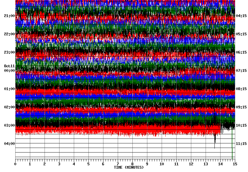
Now I think we are seeing some harmonic in the signal but either this I would not have said this was clear - not like others I have looked at. I wish I could get to hear this one to aid future identification.
It seems to be increasing which you can clearly see if you click over to the seismo view. If this is HT then what we have (not) seen so far may only just be the beginning.
ETA: The space before the O and the R in Hierro is a quirk of ATS!
Hier ro spectrum today
Now I think we are seeing some harmonic in the signal but either this I would not have said this was clear - not like others I have looked at. I wish I could get to hear this one to aid future identification.
It seems to be increasing which you can clearly see if you click over to the seismo view. If this is HT then what we have (not) seen so far may only just be the beginning.
ETA: The space before the O and the R in Hierro is a quirk of ATS!
edit on 11/10/2011 by PuterMan because: (no reason given)
reply to post by PuterMan
Jon Friemann has suggested that the magma movement could have been into an empty chamber as a result of the 4.4, if this is the case then something far more serious could be building up for the people of El Hierro.You can see his comments on Erik Klemetti's blog Eruptions @ that site Wired.
@PuterMan and Robin Marks......Hunter Full Moon today....we shall see!
Rainbows Jane
map 3.2 2011/10/11 05:01:02 31.961N -116.175W 0.2 43 km ( 27 mi) ENE of Ensenada, Mexico
map 1.4 2011/10/11 04:54:56 35.714N 121.107W 8.7 11 km ( 7 mi) NE of San Simeon, CA
map 1.6 2011/10/11 04:47:16 35.730N 121.109W 9.1 12 km ( 7 mi) NE of San Simeon, CA
map 1.7 2011/10/11 04:35:55 34.039N 118.420W 19.4 2 km ( 1 mi) S of Century City, CA
map 1.0 2011/10/11 04:15:27 33.984N 116.920W 14.8 6 km ( 4 mi) NNW of Banning, CA
map 1.5 2011/10/11 03:57:13 32.801N 116.148W 7.3 16 km (10 mi) WNW of Ocotillo, CA
map 1.8 2011/10/11 03:39:55 36.437N 121.013W 5.9 16 km (10 mi) SE of Pinnacles, CA
map 3.1 2011/10/11 03:12:27 33.516N 116.219W 35.1 15 km ( 9 mi) WSW of Mecca, CA >Deleted<
map 3.5 2011/10/11 03:12:02 34.724N 116.021W 5.4 13 km ( 8 mi) E of Ludlow, CA
map 1.3 2011/10/11 03:02:57 37.346N 117.118W 6.5 13 km ( 8 mi) ENE of Tokop, NV
map 1.2 2011/10/11 03:02:35 33.950N 116.308W 5.9 17 km (10 mi) NNE of Thousand Palms, CA
map 1.6 2011/10/11 02:56:53 39.517N 119.414W 7.7 17 km (11 mi) SW of Wadsworth, NV
map 1.4 2011/10/11 02:17:17 39.516N 119.416W 7.0 18 km (11 mi) SW of Wadsworth, NV
map 2.4 2011/10/11 02:14:15 39.519N 119.409W 5.0 17 km (10 mi) SW of Wadsworth, NV
map 1.4 2011/10/11 01:42:01 38.796N 122.767W 1.9 3 km ( 2 mi) E of The Geysers, CA
map 1.0 2011/10/11 01:11:09 38.833N 122.798W 2.1 4 km ( 2 mi) N of The Geysers, CA
map 1.4 2011/10/11 00:50:03 34.289N 116.906W 6.8 5 km ( 3 mi) N of town of Big Bear Lake, CA
map 2.9 2011/10/10 23:41:19 32.121N 115.265W 12.3 24 km (15 mi) SW of Guadalupe Victoria, Baja California, Mexico
earthquake.usgs.gov...

Magma moving and trembling last 34 hour after Oct 09, UTC ..
Readings from this station ..
earthquake.usgs.gov...
map 1.4 2011/10/11 04:54:56 35.714N 121.107W 8.7 11 km ( 7 mi) NE of San Simeon, CA
map 1.6 2011/10/11 04:47:16 35.730N 121.109W 9.1 12 km ( 7 mi) NE of San Simeon, CA
map 1.7 2011/10/11 04:35:55 34.039N 118.420W 19.4 2 km ( 1 mi) S of Century City, CA
map 1.0 2011/10/11 04:15:27 33.984N 116.920W 14.8 6 km ( 4 mi) NNW of Banning, CA
map 1.5 2011/10/11 03:57:13 32.801N 116.148W 7.3 16 km (10 mi) WNW of Ocotillo, CA
map 1.8 2011/10/11 03:39:55 36.437N 121.013W 5.9 16 km (10 mi) SE of Pinnacles, CA
map 3.1 2011/10/11 03:12:27 33.516N 116.219W 35.1 15 km ( 9 mi) WSW of Mecca, CA >Deleted<
map 3.5 2011/10/11 03:12:02 34.724N 116.021W 5.4 13 km ( 8 mi) E of Ludlow, CA
map 1.3 2011/10/11 03:02:57 37.346N 117.118W 6.5 13 km ( 8 mi) ENE of Tokop, NV
map 1.2 2011/10/11 03:02:35 33.950N 116.308W 5.9 17 km (10 mi) NNE of Thousand Palms, CA
map 1.6 2011/10/11 02:56:53 39.517N 119.414W 7.7 17 km (11 mi) SW of Wadsworth, NV
map 1.4 2011/10/11 02:17:17 39.516N 119.416W 7.0 18 km (11 mi) SW of Wadsworth, NV
map 2.4 2011/10/11 02:14:15 39.519N 119.409W 5.0 17 km (10 mi) SW of Wadsworth, NV
map 1.4 2011/10/11 01:42:01 38.796N 122.767W 1.9 3 km ( 2 mi) E of The Geysers, CA
map 1.0 2011/10/11 01:11:09 38.833N 122.798W 2.1 4 km ( 2 mi) N of The Geysers, CA
map 1.4 2011/10/11 00:50:03 34.289N 116.906W 6.8 5 km ( 3 mi) N of town of Big Bear Lake, CA
map 2.9 2011/10/10 23:41:19 32.121N 115.265W 12.3 24 km (15 mi) SW of Guadalupe Victoria, Baja California, Mexico
earthquake.usgs.gov...
Magma moving and trembling last 34 hour after Oct 09, UTC ..
Readings from this station ..
earthquake.usgs.gov...
edit on 11-10-2011 by Dalke07 because: (no reason given)
Baja just reported in:
ETA: This one seems to indicate a depth right near the surface.
Be Well.
Magnitude
3.2
Date-Time
Tuesday, October 11, 2011 at 12:01:02 UTC
Tuesday, October 11, 2011 at 05:01:02 AM at epicenter
Location
31.961°N, 116.175°W
Depth
0.2 km (~0.1 mile) (poorly constrained)
Region
BAJA CALIFORNIA, MEXICO
Distances
43 km (27 miles) ENE (76°) from Ensenada, Baja California, Mexico
46 km (28 miles) NE (54°) from Maneadero, Baja California, Mexico
73 km (45 miles) S (179°) from Jacumba Hot Springs, CA
102 km (63 miles) SE (128°) from Tijuana, Baja California, Mexico
Location Uncertainty
horizontal +/- 4.7 km (2.9 miles); depth +/- 5.4 km (3.4 miles)
Parameters
Nph= 24, Dmin=60 km, Rmss=0.4 sec, Gp=284°,
M-type=local magnitude (ML), Version=0
Source
California Integrated Seismic Net:
USGS Caltech CGS UCB UCSD UNR
Event ID
ci15062060
ETA: This one seems to indicate a depth right near the surface.
Be Well.
edit on 10/11/2011 by Bishop2199 because: (no reason given)
Now here is a small one in an area you don't see coming up too often.
Source
Magnitude MD 2.5
Region DEAD SEA REGION
Date time 2011-10-11 12:30:39.6 UTC
Location 32.57 N ; 35.18 E
Depth 3 km
Distances 33 km SE Haifa (pop 267,300 ; local time 14:30:39.6 2011-10-11)
5 km NE Umm al-fahm (pop 41,030 ; local time 14:30:39.6 2011-10-11)
4 km NW Zububa (pop 2,063 ; local time 14:30:39.6 2011-10-11)
Source
Here is a good sized one in Indonesia:
Be Well.
Magnitude
5.7
Date-Time
Tuesday, October 11, 2011 at 13:05:48 UTC
Tuesday, October 11, 2011 at 10:05:48 PM at epicenter
Time of Earthquake in other Time Zones
Location
2.296°S, 138.829°E
Depth
20.3 km (12.6 miles)
Region
PAPUA, INDONESIA
Distances
209 km (129 miles) W of Jayapura, Papua, Indonesia
274 km (170 miles) W of Vanimo, New Guinea, PNG
1429 km (887 miles) NE of DARWIN, Northern Territory, Australia
3577 km (2222 miles) E of JAKARTA, Java, Indonesia
Location Uncertainty
horizontal +/- 14.9 km (9.3 miles); depth +/- 7.5 km (4.7 miles)
Parameters
NST= 84, Nph= 85, Dmin=734.7 km, Rmss=1 sec, Gp= 32°,
M-type=teleseismic moment magnitude (Mw), Version=8
Source
Magnitude: USGS NEIC (WDCS-D)
Location: USGS NEIC (WDCS-D)
Event ID
usc00067cw
Be Well.
edit on 10/11/2011 by Bishop2199 because: (no reason given)
reply to post by PuterMan
I suspect you'll see more around the Dead Sea.
www.oilinisrael.net...
blog.bibleplaces.com...
I suspect you'll see more around the Dead Sea.
www.oilinisrael.net...
blog.bibleplaces.com...
Here's another one in California, just North of the one in Baja:
Be Well.
Magnitude
3.1
Date-Time
Tuesday, October 11, 2011 at 13:25:27 UTC
Tuesday, October 11, 2011 at 06:25:27 AM at epicenter
Location
32.646°N, 115.955°W
Depth
5.5 km (3.4 miles)
Region
SOUTHERN CALIFORNIA
Distances
11 km (7 miles) SSE (159°) from Ocotillo, CA
22 km (14 miles) E (82°) from Jacumba Hot Springs, CA
30 km (18 miles) WSW (237°) from Seeley, CA
40 km (25 miles) WSW (247°) from El Centro, CA
46 km (28 miles) W (269°) from Mexicali, Baja California, Mexico
101 km (62 miles) E (82°) from Tijuana, Baja California, Mexico
Location Uncertainty
horizontal +/- 0.4 km (0.2 miles); depth +/- 0.7 km (0.4 miles)
Parameters
Nph= 78, Dmin=3 km, Rmss=0.36 sec, Gp=155°,
M-type=local magnitude (ML), Version=0
Source
California Integrated Seismic Net:
USGS Caltech CGS UCB UCSD UNR
Event ID
ci15062076
Be Well.
Looks like they are announcing the evacuation of La Restinga on El Hierro. Tremors are being felt on La Palma. New vents/old seem to be opening up ON
LAND.
links to follow
Rinbows
Jane
links to follow
Rinbows
Jane
reply to post by Dalke07
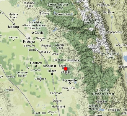
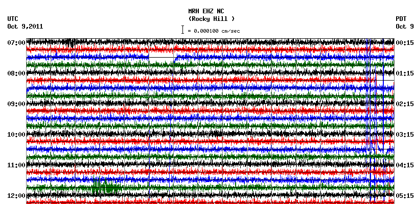
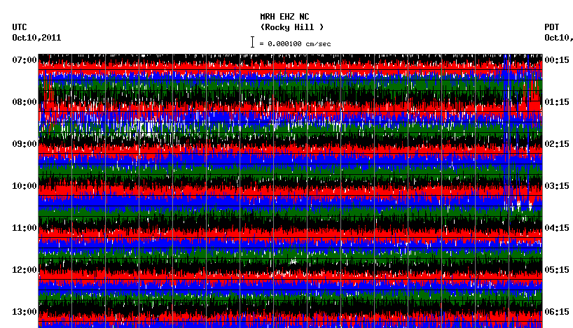
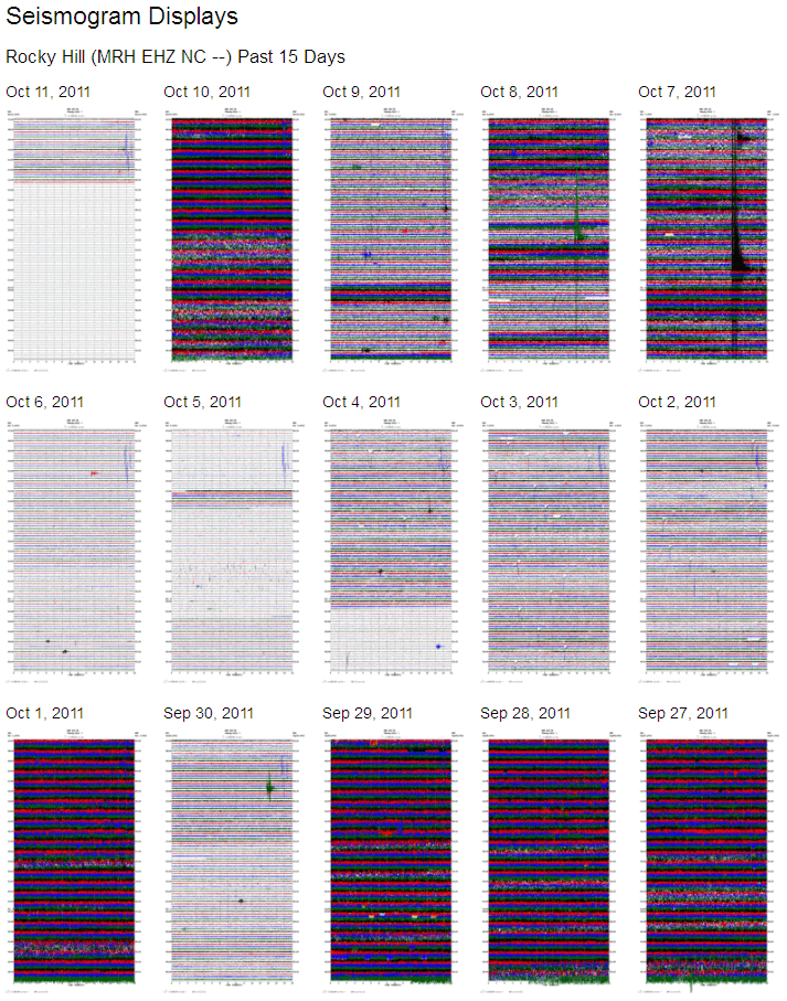
These stations in the NC network often display this signal - for weeks on end sometimes. It may have a certain similarity to the El Hierro seismogram, but you cannot make the assumption that this is magma on the move.
You should show the full image
You would then see that the setting on this instrument is 200 mV so it is fairly sensitive.
If you look at the last 15 days page you can see this happens. A couple of nice 'pops' on the 7th, but otherwise this looks pretty much like it always does.
Original
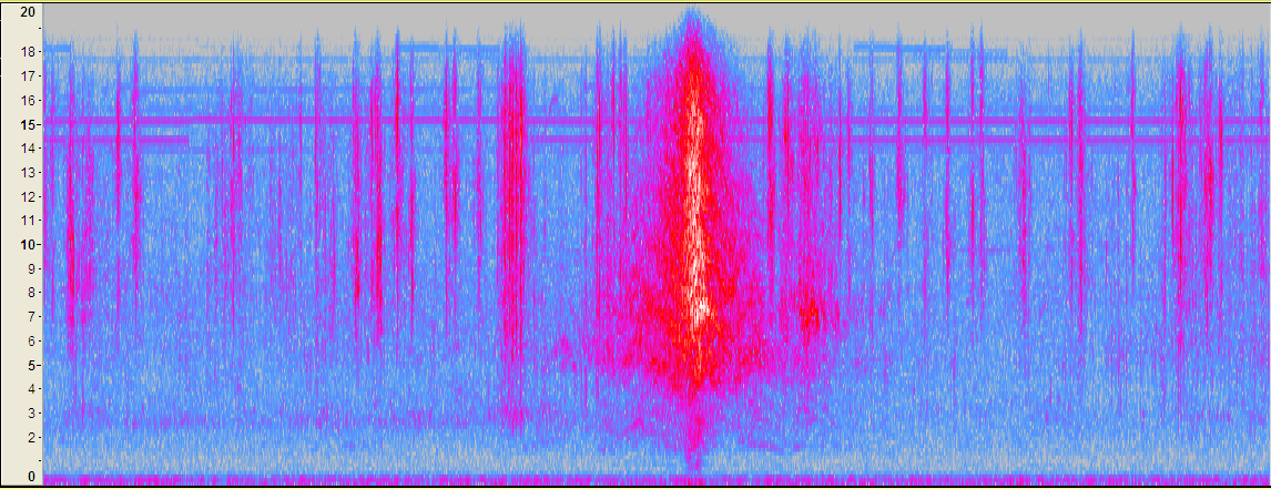
The publicly available station CI.RCT is almost right next to that seismo MRH and possibly on the same site.
Here is the plot for yesterday RCT.CI..BHZ.2011.283 and for today RCT.CI..BHZ.2011.284
The big red splodge (a technical term) is not an earthquake, in fact I would say all of this looks like wind in the background and some other interference causing the bigger signals. Magma it is not.
Here is a spectrum of the big red splodge
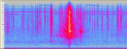
As you can see it bears no resemblance to the spectrums at El Hiero. It also sounds like electro magnetic interference.
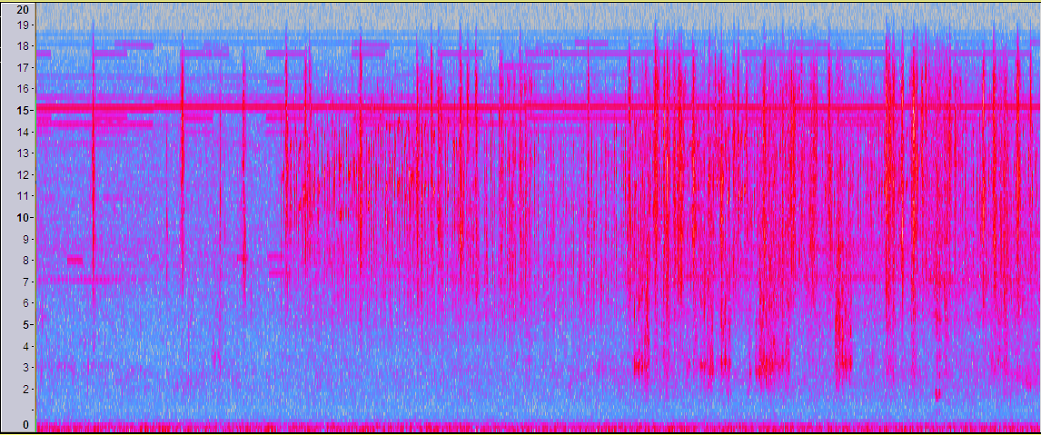
Just for good measure here is 1200 to 1400 UTC today
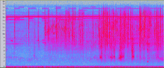
Also sounds electronic and has no HT at all.
As always with these things what something may first appear to be is not always the case, much like I said with El Hierro where the seismo looked like HT but the spectrum was odd. You always - if possible - need to find another instrument close by. In the US this is generally not a problem.
You can see that big splodge on this spectrum earthquake.usgs.gov...
Magma moving and trembling last 34 hour after Oct 09, UTC ..
These stations in the NC network often display this signal - for weeks on end sometimes. It may have a certain similarity to the El Hierro seismogram, but you cannot make the assumption that this is magma on the move.
You should show the full image
You would then see that the setting on this instrument is 200 mV so it is fairly sensitive.
If you look at the last 15 days page you can see this happens. A couple of nice 'pops' on the 7th, but otherwise this looks pretty much like it always does.
Original
The publicly available station CI.RCT is almost right next to that seismo MRH and possibly on the same site.
Here is the plot for yesterday RCT.CI..BHZ.2011.283 and for today RCT.CI..BHZ.2011.284
The big red splodge (a technical term) is not an earthquake, in fact I would say all of this looks like wind in the background and some other interference causing the bigger signals. Magma it is not.
Here is a spectrum of the big red splodge
As you can see it bears no resemblance to the spectrums at El Hiero. It also sounds like electro magnetic interference.
Just for good measure here is 1200 to 1400 UTC today
Also sounds electronic and has no HT at all.
As always with these things what something may first appear to be is not always the case, much like I said with El Hierro where the seismo looked like HT but the spectrum was odd. You always - if possible - need to find another instrument close by. In the US this is generally not a problem.
edit on 11/10/2011 by PuterMan because: (no reason given)
You can see that big splodge on this spectrum earthquake.usgs.gov...
edit on 11/10/2011 by PuterMan because: (no reason given)
reply to post by Robin Marks
Duh! Why did I not think of that? I though Sodom and Gomorrah when it should have been *snip* *snip*.*snippetty snip*
"Frackin' all over the world". Catchy little number.
Duh! Why did I not think of that? I though Sodom and Gomorrah when it should have been *snip* *snip*.*snippetty snip*
"Frackin' all over the world". Catchy little number.
edit on 11/10/2011 by PuterMan because: (no reason given)
new topics
-
Are you ready for the return of Jesus Christ? Have you been cleansed by His blood?
Religion, Faith, And Theology: 30 minutes ago -
Chronological time line of open source information
History: 1 hours ago -
A man of the people
Diseases and Pandemics: 3 hours ago -
Ramblings on DNA, blood, and Spirit.
Philosophy and Metaphysics: 3 hours ago -
4 plans of US elites to defeat Russia
New World Order: 4 hours ago -
Thousands Of Young Ukrainian Men Trying To Flee The Country To Avoid Conscription And The War
Other Current Events: 8 hours ago -
12 jurors selected in Trump criminal trial
US Political Madness: 11 hours ago -
Iran launches Retalliation Strike 4.18.24
World War Three: 11 hours ago -
Israeli Missile Strikes in Iran, Explosions in Syria + Iraq
World War Three: 11 hours ago
top topics
-
George Knapp AMA on DI
Area 51 and other Facilities: 17 hours ago, 26 flags -
Israeli Missile Strikes in Iran, Explosions in Syria + Iraq
World War Three: 11 hours ago, 17 flags -
Thousands Of Young Ukrainian Men Trying To Flee The Country To Avoid Conscription And The War
Other Current Events: 8 hours ago, 6 flags -
Iran launches Retalliation Strike 4.18.24
World War Three: 11 hours ago, 6 flags -
Not Aliens but a Nazi Occult Inspired and then Science Rendered Design.
Aliens and UFOs: 17 hours ago, 5 flags -
12 jurors selected in Trump criminal trial
US Political Madness: 11 hours ago, 4 flags -
4 plans of US elites to defeat Russia
New World Order: 4 hours ago, 2 flags -
A man of the people
Diseases and Pandemics: 3 hours ago, 2 flags -
Chronological time line of open source information
History: 1 hours ago, 2 flags -
Ramblings on DNA, blood, and Spirit.
Philosophy and Metaphysics: 3 hours ago, 1 flags
active topics
-
Are you ready for the return of Jesus Christ? Have you been cleansed by His blood?
Religion, Faith, And Theology • 3 • : Consvoli -
4 plans of US elites to defeat Russia
New World Order • 24 • : twistedpuppy -
BREAKING: O’Keefe Media Uncovers who is really running the White House
US Political Madness • 16 • : Hakaiju -
Thousands Of Young Ukrainian Men Trying To Flee The Country To Avoid Conscription And The War
Other Current Events • 6 • : Macenroe1982 -
Fossils in Greece Suggest Human Ancestors Evolved in Europe, Not Africa
Origins and Creationism • 65 • : Xtrozero -
The Tories may be wiped out after the Election - Serves them Right
Regional Politics • 24 • : crayzeed -
A man of the people
Diseases and Pandemics • 7 • : TheMichiganSwampBuck -
Israeli Missile Strikes in Iran, Explosions in Syria + Iraq
World War Three • 54 • : CarlLaFong -
12 jurors selected in Trump criminal trial
US Political Madness • 30 • : RazorV66 -
Meet Catturd who has been swatted 3 times
General Conspiracies • 22 • : 7dayhome