It looks like you're using an Ad Blocker.
Please white-list or disable AboveTopSecret.com in your ad-blocking tool.
Thank you.
Some features of ATS will be disabled while you continue to use an ad-blocker.

Why are the LROC images so lousy?
page: 7share:
from LRO image file M102781342LE.IMG line 4 with auto level
is the left part lousy or noisy ?
the right part ?
lots of LRO images have this effect/problem on the black/dark area.
but what is this effect/problem ?
CCD problem ?
noise ?
???
do you have any answer ?
if the CCD are panchromatic or multi color banded, where are the raw image files ?
did some Lola Datas are available ?
reply to post by mixmix
From my understanding, the amount of noise varies depending on the temperature of the semiconductors. There is a team of several people who try to forecast the temperature of the CCD days in advance so that they can try to get the best image possible, but it's never perfect.
There has been a pre-release of NAC images in a PDS EDR format if that's what you're wanting.
lroc.sese.asu.edu...
But unfortunately the entire LROC site is down right now, so it won't work, but hopefully it will be back soon.
From my understanding, the amount of noise varies depending on the temperature of the semiconductors. There is a team of several people who try to forecast the temperature of the CCD days in advance so that they can try to get the best image possible, but it's never perfect.
where are the raw image files ?
There has been a pre-release of NAC images in a PDS EDR format if that's what you're wanting.
lroc.sese.asu.edu...
But unfortunately the entire LROC site is down right now, so it won't work, but hopefully it will be back soon.
reply to post by jra
Thanks I will wait for LRO website is up.
For the temperature noise explanation, I think it will be more isotropic.
I'n not a LRO CCD expert.
If you zoom the image, you can see noise in bright area.
With about square pattern
strange.
The NAC or WAC camera is designed to take picture inside dark crater so
noise in dark area for a $$$ camera is surprizing.
LRO images are still the best.
But colored pictures is good too.
OP any idea or I'm ignored ?
But unfortunately the entire LROC site is down right now, so it won't work, but hopefully it will be back soon.
Thanks I will wait for LRO website is up.
For the temperature noise explanation, I think it will be more isotropic.
I'n not a LRO CCD expert.
If you zoom the image, you can see noise in bright area.
With about square pattern
strange.
The NAC or WAC camera is designed to take picture inside dark crater so
noise in dark area for a $$$ camera is surprizing.
LRO images are still the best.
But colored pictures is good too.
OP any idea or I'm ignored ?
Originally posted by mixmix
The NAC or WAC camera is designed to take picture inside dark crater so
noise in dark area for a $$$ camera is surprizing.
I'm not so sure about the NAC and WAC being designed to look at shadowed areas. The LAMP instrument however, is designed to look at the areas in permanent shadow.
It's difficult to discuss of LRO camera when the LROC website is still down since 3 days.
last RSS feed is "A lunar valentine"
is this entertainment ?
So it's about 6 months that the first LRO images are released and nobody noticed that the CCD have a noise problem or not.
[edit on 20-2-2010 by mixmix]
last RSS feed is "A lunar valentine"
is this entertainment ?
So it's about 6 months that the first LRO images are released and nobody noticed that the CCD have a noise problem or not.
[edit on 20-2-2010 by mixmix]
Much of the previously posted LROC data is currently offline due to a problem with the primary LROC mass storage system. Because the volume is very large, inspecting and restoring all the files takes a long time. As data are restored they are being returned to the webpage. We hope to have the LROC webpage fully restored by the end of the day on February 24.
from
lroc.sese.asu.edu...
reply to post by jra
Sorry jra,
but the IMG files from your links are B&W pictures.
It's not raw color images.
Or I'm wrong somewhere?
LRO site is back.
where are the raw image files ? There has been a pre-release of NAC images in a PDS EDR format if that's what you're wanting. lroc.sese.asu.edu...
Sorry jra,
but the IMG files from your links are B&W pictures.
It's not raw color images.
Or I'm wrong somewhere?
LRO site is back.
The highest resolution commercial satellite, as I found it on google, has a resolution of 41 cm / pixel:
www.sciencedaily.com...
According to this: hypertextbook.com...
military satellites can have up to 5 cm resolution.
So, until we clearly see the lunar vehicle in a photograph clearly, let us remain skeptic.
According to this: hypertextbook.com...
military satellites can have up to 5 cm resolution.
So, until we clearly see the lunar vehicle in a photograph clearly, let us remain skeptic.
reply to post by masterp
[atsimg]http://files.abovetopsecret.com/images/member/b7e5aa78ca6a.jpg[/atsimg]
[atsimg]http://files.abovetopsecret.com/images/member/b7e5aa78ca6a.jpg[/atsimg]
Originally posted by mixmix
Sorry jra,
but the IMG files from your links are B&W pictures.
It's not raw color images.
Or I'm wrong somewhere?
Although I can't say for certain, but I don't think you'd ever get colour RAW images from any probe. Be it from, NASA, ESA, JAXA or who ever. Colour images are produced by combining multiple images taken at different wavelengths. The LROC Narrow Angle Cameras (NAC) don't have filters to take images at different wavelengths as far as I can see, but the Wide Angle Camera (WAC) has 7 filters that cover every thing between red and ultraviolet.
Here's one colour WAC image
reply to post by Phage
You still using that old chestnut?
Come on Phage,give people some credit.
There are many places which are NO FLY ZONES,which on Google Earth you can still zoom right down on and view clearly objects the same size as the lander.
[edit on 27/2/10 by gallifreyan medic]
You still using that old chestnut?
Come on Phage,give people some credit.
There are many places which are NO FLY ZONES,which on Google Earth you can still zoom right down on and view clearly objects the same size as the lander.
[edit on 27/2/10 by gallifreyan medic]
Originally posted by gallifreyan medic
There are many places which are NO FLY ZONES,which on Google Earth you can still zoom right down on and view clearly objects the same size as the lander.
This is a testable hypothesis. Would you care to name such a place?
reply to post by Saint Exupery
Here are 2 links for information of No fly/Restricted zones.
WIKI
FAA
More information of places around the world can I'm sure be found on Google.
And on GE you can see what can be seen within these areas.
Also here is a link to a place that's a little hard for Google to take pics.
Zoom out for where it is.
Where could it be ???
So,lucky they use satellites isn't it.
[edit on 1/3/10 by gallifreyan medic]
Originally posted by Point of No Return
reply to post by Phage
Nice APOLLOgetic thread, Phage.
Just admit that the pictures are crap, and that they are useless.
NASA wanted to put an end to the speculation, and they come out with this?
Is this the best they can at this moment?
Google earth can zoom in much further than that.
edit to add. So, it's beyond me why you would compare the lunar picture to a pic of Rio, with that kind of zoom.
I can show pics of Earth that are zoomed in much further, where you can clearly make out , for instance, pick up trucks.
You make it look like those lunar pics are the best we can do, wich I don't believe.
[edit on 19-7-2009 by Point of No Return]
Ill take a guess and say the sattelites that can resolve a pickup truck are purpose built and largaer than the LROC, with more space dedicated to the capture equipment. The best sattelites in orbit can resolve a license plate. The LROC had probably to accomodate an array of instruments, so they werent able to fit one of the more advanced cameras they have.
Great thread Phage it really brings down to earth the astronomical expectations some 'skeptics' have about some aspects of imaging telephotography.
The rest of the speculations can be figured out with math calculations of the receptor circumferences and focal length and distance from the subject.
Originally posted by masterp
The highest resolution commercial satellite, as I found it on google, has a resolution of 41 cm / pixel: www.sciencedaily.com...
According to this: hypertextbook.com...
military satellites can have up to 5 cm resolution.
So, until we clearly see the lunar vehicle in a photograph clearly, let us remain skeptic.
There's enough data from the LRO and SELENE to verify images and footprints on the moon from 1969-1972 could not have been faked. Now I suppose we'll go into the realm that it was robots and not man that made those signatures, huh.
Perhaps interesting for others then myself also.
NASA will soon show some new images of three Apollo landing sites taken from the agency's Lunar Reconnaissance Orbiter, or LRO.
I am really curious to the quality of those images.
www.nasa.gov...
NASA will soon show some new images of three Apollo landing sites taken from the agency's Lunar Reconnaissance Orbiter, or LRO.
I am really curious to the quality of those images.
NASA Announces Media Teleconference on New Apollo Images
GREENBELT, Md. -- NASA will host a media teleconference at noon on Tuesday, Sept. 6, to reveal new images of three Apollo landing sites taken from the agency's Lunar Reconnaissance Orbiter, or LRO.
Supporting information and visuals for the briefing will be posted at 11:45 a.m. EDT Sept. 6 at:
www.nasa.gov...
Audio of the teleconference will be streamed live on the Web at:
www.nasa.gov...
www.nasa.gov...
This thread must be a joke...
The picture of Rio de Janeiro presented by Phage in the first post has a much better quality of image than the Moon picture presented in the same post.
Also, here is a link to Google Maps, with satellite images of exactly the SAME PLACE ON RIO DE JANEIRO:
http:// maps.google.com/maps ?ll=-22.899879,-43.176084& spn=0.000974,0.001206&t=k&z=20
(copy, paste, and eliminate the blank spaces)
Please, I beg everyone to visit that link, and check the satellite images of Google Maps, of exactly the SAME PLACE ON RIO DE JANEIRO that Phage has shown in the picture in the first post.
As you can see, the cars in the picture are CLEARLY visible.
So, Phage, who are you trying to fool here?
edit on 31-5-2012 by GLontra because: (no reason given)
reply to post by GLontra
Remove the color
Remove the buildings
Remove the roads
Remove everything human
Cover the ground with sand
Leave one white pickup truck
How does it look now?
Please, I beg everyone to visit that link, and check the satellite images of Google Maps, of exactly the SAME PLACE ON RIO DE JANEIRO that Phage has shown in the picture in the first post.
As you can see, the cars in the picture are CLEARLY visible.
So, Phage, who are you trying to fool here?
Remove the color
Remove the buildings
Remove the roads
Remove everything human
Cover the ground with sand
Leave one white pickup truck
How does it look now?
Originally posted by samkent
reply to post by GLontra
Please, I beg everyone to visit that link, and check the satellite images of Google Maps, of exactly the SAME PLACE ON RIO DE JANEIRO that Phage has shown in the picture in the first post.
As you can see, the cars in the picture are CLEARLY visible.
So, Phage, who are you trying to fool here?
Remove the color
Remove the buildings
Remove the roads
Remove everything human
Cover the ground with sand
Leave one white pickup truck
How does it look now?
Thank you, samkent.
I was going to say something similar. If you zoom up the rio de jeneiro picture to see objects the same size as the moon picture, the resolutions are quite comparable (considering that the LEM descent stage is about the size of a large pickup truck):
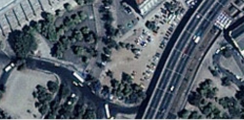

I'm not sure if the Rio picture is even at a good enough resolution to show the footpaths that we see on the Apollo picture, but it seems at least close enough.
By the way, since this thread was started by phage almost 3 years ago, better resolution pictures have been taken of the Apollo sites, as the LRO spacecraft gets into better positions to see each site (lower orbits, better sun angle, etc.). Here is one of the Apollo 17 site. This resolution on this one is definitely at least as good as the Rio de Janeiro image (if not much better):
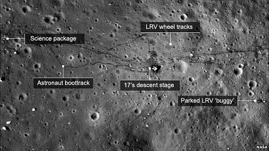
Image Source
...and GLontra --
what is the source of that Goolgemaps image you posted?
edit on 5/31/2012 by Soylent Green Is People because: (no reason given)
new topics
-
James O’Keefe: I have evidence that exposes the CIA, and it’s on camera.
Whistle Blowers and Leaked Documents: 29 minutes ago -
Australian PM says the quiet part out loud - "free speech is a threat to democratic dicourse"...?!
New World Order: 1 hours ago -
Ireland VS Globalists
Social Issues and Civil Unrest: 1 hours ago -
Biden "Happy To Debate Trump"
Mainstream News: 2 hours ago -
RAAF airbase in Roswell, New Mexico is on fire
Aliens and UFOs: 2 hours ago -
What is the white pill?
Philosophy and Metaphysics: 3 hours ago -
Mike Pinder The Moody Blues R.I.P.
Music: 4 hours ago -
Putin, Russia and the Great Architects of the Universe
ATS Skunk Works: 7 hours ago
top topics
-
President BIDEN's FBI Raided Donald Trump's Florida Home for OBAMA-NORTH KOREA Documents.
Political Conspiracies: 17 hours ago, 35 flags -
A Warning to America: 25 Ways the US is Being Destroyed
New World Order: 12 hours ago, 20 flags -
Mike Pinder The Moody Blues R.I.P.
Music: 4 hours ago, 7 flags -
What is the white pill?
Philosophy and Metaphysics: 3 hours ago, 5 flags -
Biden "Happy To Debate Trump"
Mainstream News: 2 hours ago, 5 flags -
Australian PM says the quiet part out loud - "free speech is a threat to democratic dicourse"...?!
New World Order: 1 hours ago, 4 flags -
RAAF airbase in Roswell, New Mexico is on fire
Aliens and UFOs: 2 hours ago, 4 flags -
Putin, Russia and the Great Architects of the Universe
ATS Skunk Works: 7 hours ago, 3 flags -
Ireland VS Globalists
Social Issues and Civil Unrest: 1 hours ago, 2 flags -
James O’Keefe: I have evidence that exposes the CIA, and it’s on camera.
Whistle Blowers and Leaked Documents: 29 minutes ago, 1 flags
active topics
-
Supreme Court Oral Arguments 4.25.2024 - Are PRESIDENTS IMMUNE From Later Being Prosecuted.
Above Politics • 100 • : Vermilion -
James O’Keefe: I have evidence that exposes the CIA, and it’s on camera.
Whistle Blowers and Leaked Documents • 4 • : theatreboy -
Russia Ukraine Update Thread - part 3
World War Three • 5735 • : gortex -
"We're All Hamas" Heard at Columbia University Protests
Social Issues and Civil Unrest • 288 • : FlyersFan -
University of Texas Instantly Shuts Down Anti Israel Protests
Education and Media • 288 • : FlyersFan -
Biden "Happy To Debate Trump"
Mainstream News • 31 • : theatreboy -
Gaza Terrorists Attack US Humanitarian Pier During Construction
Middle East Issues • 84 • : YourFaceAgain -
President BIDEN's FBI Raided Donald Trump's Florida Home for OBAMA-NORTH KOREA Documents.
Political Conspiracies • 33 • : theatreboy -
Hate makes for strange bedfellows
US Political Madness • 52 • : YourFaceAgain -
-@TH3WH17ERABB17- -Q- ---TIME TO SHOW THE WORLD--- -Part- --44--
Dissecting Disinformation • 697 • : Thoughtful3