It looks like you're using an Ad Blocker.
Please white-list or disable AboveTopSecret.com in your ad-blocking tool.
Thank you.
Some features of ATS will be disabled while you continue to use an ad-blocker.

Pine Gap Hangar?
page: 10
share:
G'day all. I am starting this thread as a viable alternative to Mungodave's "Pine Gap Underground Entrances". That thread has gotten off track and
I believe that rather than constantly quiz Doghead on what he has seen/done/been etc. we all need to devote a little time to examining this facility
and its surrounds.
I think that I may have found; what to me (and my 11yo son without any solicitation whatsoever from myself) looks like a hangar door in the side of a mountain range within the confines of Pine Gap's land.
Go to 23 48' 42.75"S 133 43' 7.49"E (right below this point is the anomaly that I am talking about). Tell me what you see as I don't want to pre-condition anyone's minds to see something that may not be there!!
Melbourne Militia/Zorgon et al; if you know how to do a screen capture of this vicinity using Google Earth could you do it and post it for me please as I truly believe that this is a significant find!! Get on it guys and gals as I am looking for validation other than having had too much Bundy to drink!
Is this what you are talking about?
Click Here for Google Maps
If so... here are some screenshots:
It is an odd 'end' to a road and does appear to disappear in the mountain.
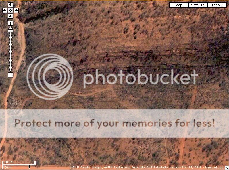
... however, when looking close i don't see too much in the form of a hangar door. I appears to be flat ground that has been worn from vehicles turning around. That being said, why would vehicles head up that seemingly dead end road?

What does strike me as odd is the poor job google has done on those images. There is plenty of watermarks half scrubbed and poorly stitched and smudged areas.
Will be interesting what others make of the images.
Click Here for Google Maps
If so... here are some screenshots:
It is an odd 'end' to a road and does appear to disappear in the mountain.
... however, when looking close i don't see too much in the form of a hangar door. I appears to be flat ground that has been worn from vehicles turning around. That being said, why would vehicles head up that seemingly dead end road?
What does strike me as odd is the poor job google has done on those images. There is plenty of watermarks half scrubbed and poorly stitched and smudged areas.
Will be interesting what others make of the images.
Look to me like the road where the arrow points to curves to the right and continues? Maybe not as well worn as the start of the track but it does
appear to continue to the bottom right of the first pic. Am I seeing this correctly?
Thanks Silent Shadow; that's exactly it! How did you do the screen capture to post it? When I zoom in it shows a triangular shaped structure in the
side fo the mountain with what appears to be two square portholes in each door; quite well camouflaged (similar in colour to the surroundings); but
there is something definitely there! I have just downloaded google earth in the last couple of days and am running google earth plus; at the bottom of
the screen it say Image 2008 DigitalGlobe.
Wife just walked in (huge skeptic) but even she agrees there is something there!
Wife just walked in (huge skeptic) but even she agrees there is something there!
Shameless thread bump. Use Google Earth zoom in and then change the angle at which you are looking at this anomaly. Come on; this is the kind of stuff
that this site feeds on so please take a look! Maybe someone with photo interpreting skills can investigate and enhance the area in question.
[edit on 8/2/2008 by celeritas]
[edit on 8/2/2008 by celeritas]
From what I have looked at on the PG area there are numerous "dead ends" on numerous roads there. Not sure why this one strikes you as any
different from the others. I believe even in the original PG thread the OP said the underground entrance was found after tracing multiple dead end
roads around the facility. Not sure why the dead ends, but if they aren't going to cover the big underground entrance then why would they bother
covering these smaller ones up?
G'day Vasa. So can I infer from your post that you see something there as well? Seems pretty well camouflaged and these things are only starting to
be seen with the advent of higher resolution, commercially available satellite photography. My question is why would you have a door (if that is what
it is) in the side of a ridgeline; in the centre of Australia, on the land encompassing one of the most secretive installations in the country
Originally posted by celeritas
Thanks Silent Shadow; that's exactly it! How did you do the screen capture to post it?
Hit the print screen button on your keyboard. Open up Microsoft Paint, edit->paste. Fiddle around with the picture resizing etc. Save. Host the picture online then link it in here.
Originally posted by celeritasWhen I zoom in it shows a triangular shaped structure in the side fo the mountain with what appears to be two square portholes in each door; quite well camouflaged (similar in colour to the surroundings);
I can't say i see what you can see. The only triangular shapes i can see are the shadows from the trees in the area.
img151.imageshack.us...
Thanks mate for the advice. Look inside the triangle and tell me what you see; might be a stretch but I see what looks like another triangle divided into two doors with what appears to be two square portholes equidistant and part of each door. This is situated at the end of the cleared area and into the side of the range.
[edit on 8/2/2008 by celeritas]
No problem mate...
Anyway... it took me a while to see what you meant, i inverted the colours and was able to see. The reason it took me a while was that i found it hard to get past what i saw in the triangle.
The original...

What you saw?

What i saw...

In saying that, i think we may just be looking at inconsistencies in pixelation. I would be wonderful if someone could get a ground eye look at that spot though just to be sure. If i lived within a few minutes of it i would wander over there lol...
Anyway... it took me a while to see what you meant, i inverted the colours and was able to see. The reason it took me a while was that i found it hard to get past what i saw in the triangle.
The original...
What you saw?
What i saw...
In saying that, i think we may just be looking at inconsistencies in pixelation. I would be wonderful if someone could get a ground eye look at that spot though just to be sure. If i lived within a few minutes of it i would wander over there lol...
SS that's exactly what I was talking about! If you go back to your original screen captures, this "triangle" anomaly still stands out and I do not
believe that it is caused by any sort of natural features. Further the "portholes" do not seem to be caused by any sort of shadows from vegetation.
The "triangle" appears to have a similar hue to the cleared turnaround area in front but slightly different to the rest of the area. Additionally,
if you look left and right of the triangle; you can see for want of a better term, a definite contour line where the flat turnaround area meets the
side of the ridge and the lay of the land changes gradient. The "triangle" seems set into and separate from the rest of the ridge which leads me to
believe that it is not a natural feature and is indeed a hangar door!! My very rough guesstimate has it approximately 40-60 feet wide and 20-30 feet
high (at the apex)!!
Anyone out there with imagery analysis skills - I don't think that this is inconsistencies in pixelation and could be the real deal!!!!
Anyone out there with imagery analysis skills - I don't think that this is inconsistencies in pixelation and could be the real deal!!!!
new topics
-
President BIDEN's FBI Raided Donald Trump's Florida Home for OBAMA-NORTH KOREA Documents.
Political Conspiracies: 4 hours ago -
Maestro Benedetto
Literature: 6 hours ago -
Is AI Better Than the Hollywood Elite?
Movies: 6 hours ago -
Las Vegas UFO Spotting Teen Traumatized by Demon Creature in Backyard
Aliens and UFOs: 10 hours ago -
2024 Pigeon Forge Rod Run - On the Strip (Video made for you)
Automotive Discussion: 10 hours ago -
Gaza Terrorists Attack US Humanitarian Pier During Construction
Middle East Issues: 11 hours ago
top topics
-
President BIDEN's FBI Raided Donald Trump's Florida Home for OBAMA-NORTH KOREA Documents.
Political Conspiracies: 4 hours ago, 26 flags -
Krystalnacht on today's most elite Universities?
Social Issues and Civil Unrest: 16 hours ago, 9 flags -
Supreme Court Oral Arguments 4.25.2024 - Are PRESIDENTS IMMUNE From Later Being Prosecuted.
Above Politics: 16 hours ago, 8 flags -
Weinstein's conviction overturned
Mainstream News: 14 hours ago, 8 flags -
Gaza Terrorists Attack US Humanitarian Pier During Construction
Middle East Issues: 11 hours ago, 8 flags -
Massachusetts Drag Queen Leads Young Kids in Free Palestine Chant
Social Issues and Civil Unrest: 13 hours ago, 7 flags -
Las Vegas UFO Spotting Teen Traumatized by Demon Creature in Backyard
Aliens and UFOs: 10 hours ago, 6 flags -
Meadows, Giuliani Among 11 Indicted in Arizona in Latest 2020 Election Subversion Case
Mainstream News: 13 hours ago, 5 flags -
2024 Pigeon Forge Rod Run - On the Strip (Video made for you)
Automotive Discussion: 10 hours ago, 4 flags -
Is AI Better Than the Hollywood Elite?
Movies: 6 hours ago, 3 flags
active topics
-
President BIDEN's FBI Raided Donald Trump's Florida Home for OBAMA-NORTH KOREA Documents.
Political Conspiracies • 17 • : BingoMcGoof -
Gaza Terrorists Attack US Humanitarian Pier During Construction
Middle East Issues • 29 • : 19Bones79 -
Supreme Court Oral Arguments 4.25.2024 - Are PRESIDENTS IMMUNE From Later Being Prosecuted.
Above Politics • 90 • : Lumenari -
Las Vegas UFO Spotting Teen Traumatized by Demon Creature in Backyard
Aliens and UFOs • 12 • : KrustyKrab -
SHORT STORY WRITERS CONTEST -- April 2024 -- TIME -- TIME2024
Short Stories • 23 • : DontTreadOnMe -
Truth Social goes public, be careful not to lose your money
Mainstream News • 130 • : Astyanax -
Is AI Better Than the Hollywood Elite?
Movies • 13 • : Justoneman -
Hate makes for strange bedfellows
US Political Madness • 47 • : 19Bones79 -
-@TH3WH17ERABB17- -Q- ---TIME TO SHOW THE WORLD--- -Part- --44--
Dissecting Disinformation • 689 • : daskakik -
University of Texas Instantly Shuts Down Anti Israel Protests
Education and Media • 265 • : Astrocometus
0