It looks like you're using an Ad Blocker.
Please white-list or disable AboveTopSecret.com in your ad-blocking tool.
Thank you.
Some features of ATS will be disabled while you continue to use an ad-blocker.

Amazing Site Of A Lost Civilization On Mars!!
page: 1share:
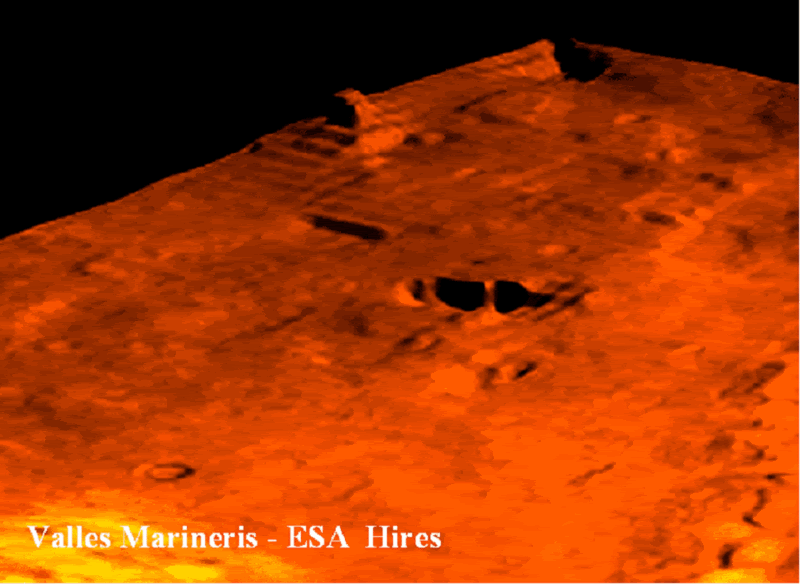
Here’s a hires image of the Valles Marineris on Mars taken from the ESA Mars collection. Look carefully at the first image. Do you notice anything
out of the ordinary? Or is it just a barren, uninteresting landscape?
Well, if you can’t make out much, have a look at the second image which I have annotated and marked certain anomalous structures. It looks like the ruins of an ancient civilization with a ‘temple’ on one side of a small city with what looks like the city’s water tank towards the top right. This depression is too regular in shape to be a crater.
Images Courtesy: ESA
This looks fascinating and I strongly believe that this is an ancient site of a civilization long gone. And also notice the resemblance of the ‘temple’ with the ancient temples here. Was there a Mars, Nimrod, and Marduk connection after all?
Cheers!
www.ldolphin.org...
ESA
[edit on 25-2-2007 by mikesingh]
Well, if you can’t make out much, have a look at the second image which I have annotated and marked certain anomalous structures. It looks like the ruins of an ancient civilization with a ‘temple’ on one side of a small city with what looks like the city’s water tank towards the top right. This depression is too regular in shape to be a crater.
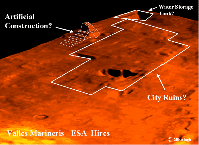
Images Courtesy: ESA
This looks fascinating and I strongly believe that this is an ancient site of a civilization long gone. And also notice the resemblance of the ‘temple’ with the ancient temples here. Was there a Mars, Nimrod, and Marduk connection after all?
Cheers!
www.ldolphin.org...
ESA
[edit on 25-2-2007 by mikesingh]
Can you post the original link to the photos used to make these enhancements? It looks convincing enough on these, but I woud like to see the
originals.
This is a GREAT FIND. The geometric anomolies are more than abudndant in this sample... an archaeologist might just someday get up there to get the
REAL DEAL on what Mars is all about!
OUTSTANDING! VERY WELL DONE!
Cheersbackatcha!
SPout
OUTSTANDING! VERY WELL DONE!
Cheersbackatcha!
SPout
Looks interesting, could those qaudratic patterns be from banding? they do run at 90 patterns to the edges of the image.
Just trying to keep an open mind.
The orinal esa image Valles Marineris
The features are strangley absent from other images of Valles Marineris.
www.esa.int...
The area in question should be in the bottom right.
www.esa.int...
Bottom left.
A glitch in the 3d data or signs of a coverup?
Just trying to keep an open mind.
The orinal esa image Valles Marineris
The features are strangley absent from other images of Valles Marineris.
www.esa.int...
The area in question should be in the bottom right.
www.esa.int...
Bottom left.
A glitch in the 3d data or signs of a coverup?
Originally posted by squiz
The orinal esa image Valles Marineris
In this photo you can clearly see the objects that MS has pointed out, in this picture i would also liek to point out that further down in the bottem right corner you can see more geomettic lines that is intresting to look at.
Originally posted by squiz
A glitch in the 3d data or signs of a coverup?
The perspective views are computer generated using the stereo images taken from overhead, those images are not taken from that perspective.
I think that it probably is a result of inconsistent data on the borders of the image, a similar effect can be seen in other places on the borders of the image.
Originally posted by acmeartifacts
Could you point to the location on this map?
marsoweb.nas.nasa.gov...
I can't, but the ESA site says:
The location is in Valles Marineris at 5° North and 323° East.
I think that particular area was not (yet ?) photographed by HiRISE.
On the esa website they have deleted the larger TIFF files for these images. Also the site does not show up in some other photos that show the same
area.
So this was either airbrushed out of the other photos, or the 3d image has errors
So this was either airbrushed out of the other photos, or the 3d image has errors
The question is why is mike posting known doctored images of mars . This is the second in a week --the first being the symbols he pasted in the
cydonia region and this the second
Originally posted by acmeartifacts
On the esa website they have deleted the larger TIFF files for these images.
Have you seen those TIFF files on previous ocasions? I have the JPG since last year but I do not have the TIFF, and I usualy download both versions.
timoothy
I don't think you can call this image a "doctored image", this is from the official ESA site, not something found by "a friend" like in the other case.
Originally posted by mikesingh
Images Courtesy: ESA
[edit on 25-2-2007 by mikesingh]
Definitely intriguing images... Brings forth the question of Nasa Airbrushing photos before they reach the public eye...Kinda reminds me of the moon base photos, but with more evidentiary Geometric shapes. The Temple I see, but I don't know for sure about a giant water resevoir... This image looks like a lot of the land formation in the area was water eroded(maybe even underwater). If its eroded it was near a riverway.... Maybe the hole is an ancient Pit Mine???
just another opinion..
Coven Out
~~Carson Stole my Tag Line, So I Gave His Girlfriend The Clap~~
Exactly, its an official photo. The problem is this photo shows the anomoly and the others on the same website do not.
So either ESA doctored the anomoly in or airbrushed it out. Either way there is something to this case.
timoothy
I don't think you can call this image a "doctored image", this is from the official ESA site, not something found by "a friend" like in the other case.
So either ESA doctored the anomoly in or airbrushed it out. Either way there is something to this case.
timoothy
I don't think you can call this image a "doctored image", this is from the official ESA site, not something found by "a friend" like in the other case.
Originally posted by acmeartifacts
The problem is this photo shows the anomoly and the others on the same website do not.
This is not a photo, its a computer generated image using the images taken from overhead.
[edit on 25/2/2007 by ArMaP]
Is there any possibility it could be an Atoll as recently explained on the below link.
underwater pyramid found in american samoa
What is the scale of that picture and how big would the object and area be?
Very intriguing although I think this has been bought up here on ats before if not I have seen this somewhere.
underwater pyramid found in american samoa
What is the scale of that picture and how big would the object and area be?
Very intriguing although I think this has been bought up here on ats before if not I have seen this somewhere.
Originally posted by kode
What is the scale of that picture and how big would the object and area be?
The ESA site says that the area is 50km accross, but that is the original image, not the image posted by Mikesingh.
It looks very interesting, but I am curious to see if it really is just odd land formations.
The 'stepping' pattern is more likely due to a lower res 3d model. For these 3d generated images, the 3d mesh detail isn't very high. So it will
look more angular. I don't think these 3d images are a good source if you're wanting accurate detail. Best to stick with actual photos in my
opinion.
I'm not an expert on photography but that's probably what you get for using CGI with the photos so you can accurately tell what the landscape is
like. I say that the photos aren't more then a mere odd formation in land.
new topics
-
President BIDEN's FBI Raided Donald Trump's Florida Home for OBAMA-NORTH KOREA Documents.
Political Conspiracies: 2 hours ago -
Maestro Benedetto
Literature: 3 hours ago -
Is AI Better Than the Hollywood Elite?
Movies: 3 hours ago -
Las Vegas UFO Spotting Teen Traumatized by Demon Creature in Backyard
Aliens and UFOs: 7 hours ago -
2024 Pigeon Forge Rod Run - On the Strip (Video made for you)
Automotive Discussion: 8 hours ago -
Gaza Terrorists Attack US Humanitarian Pier During Construction
Middle East Issues: 8 hours ago -
The functionality of boldening and italics is clunky and no post char limit warning?
ATS Freshman's Forum: 9 hours ago -
Meadows, Giuliani Among 11 Indicted in Arizona in Latest 2020 Election Subversion Case
Mainstream News: 10 hours ago -
Massachusetts Drag Queen Leads Young Kids in Free Palestine Chant
Social Issues and Civil Unrest: 10 hours ago -
Weinstein's conviction overturned
Mainstream News: 11 hours ago
top topics
-
President BIDEN's FBI Raided Donald Trump's Florida Home for OBAMA-NORTH KOREA Documents.
Political Conspiracies: 2 hours ago, 20 flags -
Krystalnacht on today's most elite Universities?
Social Issues and Civil Unrest: 13 hours ago, 9 flags -
University of Texas Instantly Shuts Down Anti Israel Protests
Education and Media: 16 hours ago, 8 flags -
Supreme Court Oral Arguments 4.25.2024 - Are PRESIDENTS IMMUNE From Later Being Prosecuted.
Above Politics: 13 hours ago, 8 flags -
Weinstein's conviction overturned
Mainstream News: 11 hours ago, 7 flags -
Massachusetts Drag Queen Leads Young Kids in Free Palestine Chant
Social Issues and Civil Unrest: 10 hours ago, 7 flags -
Gaza Terrorists Attack US Humanitarian Pier During Construction
Middle East Issues: 8 hours ago, 7 flags -
Meadows, Giuliani Among 11 Indicted in Arizona in Latest 2020 Election Subversion Case
Mainstream News: 10 hours ago, 5 flags -
Las Vegas UFO Spotting Teen Traumatized by Demon Creature in Backyard
Aliens and UFOs: 7 hours ago, 4 flags -
2024 Pigeon Forge Rod Run - On the Strip (Video made for you)
Automotive Discussion: 8 hours ago, 3 flags
active topics
-
Massachusetts Drag Queen Leads Young Kids in Free Palestine Chant
Social Issues and Civil Unrest • 14 • : ToneD -
President BIDEN's FBI Raided Donald Trump's Florida Home for OBAMA-NORTH KOREA Documents.
Political Conspiracies • 6 • : pianopraze -
British TV Presenter Refuses To Use Guest's Preferred Pronouns
Education and Media • 169 • : WakeUpBeer -
Is AI Better Than the Hollywood Elite?
Movies • 11 • : rickymouse -
Supreme Court Oral Arguments 4.25.2024 - Are PRESIDENTS IMMUNE From Later Being Prosecuted.
Above Politics • 83 • : Sookiechacha -
Sol Et Luna - TIME2024
Short Stories • 10 • : BrotherKinsMan -
University of Texas Instantly Shuts Down Anti Israel Protests
Education and Media • 263 • : cherokeetroy -
Gaza Terrorists Attack US Humanitarian Pier During Construction
Middle East Issues • 26 • : nugget1 -
Manly P. Hall says Freemasonry is a religion?
Secret Societies • 22 • : Therealbeverage -
One Flame Throwing Robot Dog for Christmas Please!
Weaponry • 11 • : Therealbeverage