It looks like you're using an Ad Blocker.
Please white-list or disable AboveTopSecret.com in your ad-blocking tool.
Thank you.
Some features of ATS will be disabled while you continue to use an ad-blocker.

Hurricane Hitting Southeast US by July 18th
page: 2share:
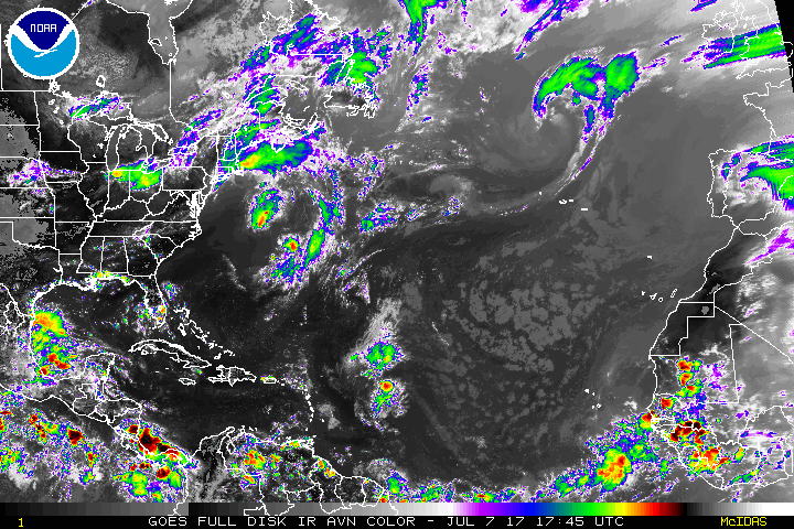
Tropical Depression Four formed in the Central Atlantic on Wednesday evening, but is struggling against dry air and is unlikely to survive long enough to threaten any land areas. At 11 am EDT Thursday, TD 4 was located about midway between the Cabo Verde Islands and the Lesser Antilles Islands, and was headed west-northwest at a speedy 21 mph.
Satellite images on Thursday morning showed that the circulation of TD 4 was weakening. The storm had a decreasing amount of thunderstorm activity, and the cloud tops of these thunderstorms were warming, showing that they did not extend as high in the atmosphere due to weaker updrafts supporting them. This weakening trend was likely due to dry air from the Saharan Air Layer (SAL), which had wrapped into the circulation center from the east. Wind shear was favorable for development, a light 5 - 10 knots, and sea surface temperatures (SSTs) were marginal for development, near 26.5°C (80°F)--about 1°F above the seasonal norm.
...
there is a brief opportunity for TD 4 to get its act together and become Tropical Storm Don. By Friday night, though, strong upper level winds out of the west will begin impacting the storm, bringing high wind shear of 15 – 25 knots through the weekend. The combination of dry air and high wind shear should be enough to destroy TD 4 by Monday.
www.wunderground.com...
a reply to: roadgravel
The GFS does show a strong wave perhaps forming into a storm next week
But way down south like 10-15n and South America
Similar to the previous storm that tried to develop down their earlier this year
The GFS does show a strong wave perhaps forming into a storm next week
But way down south like 10-15n and South America
Similar to the previous storm that tried to develop down their earlier this year
a reply to: iWontGiveUP
Yes.
I can understand the disbelief by7 many here, and it goes without question that it is very early in the prediction cycle for this. However, science has been long striving to perfect the prediction of major weather systems. I for one love to push tech to it's edge, and well, here we are attempting to predict weather two weeks out.
I will be using this as a test run of the systems capabilities. It will be interesting to see how this all plays out and just how accurate it turns out to be.
We get them here all the time . Ive been through two that
destroyed my city. We have partys during them lol.
Everyone will hang out outside till the trees start coming down or
a power line snaps lol.
destroyed my city. We have partys during them lol.
Everyone will hang out outside till the trees start coming down or
a power line snaps lol.
Sure it's a stretch to predict this far ahead but it doesn't hurt to be forewarned about a potential disaster
originally posted by: scraedtosleep
We get them here all the time . Ive been through two that
destroyed my city. We have partys during them lol.
Everyone will hang out outside till the trees start coming down or
a power line snaps lol.
Been through a few hurricane parties myself. After hurricane parties are awesome because everyone grills out the frozen meat in the freezer after the power goes out. Runs to the store to get beer and dry ice . helping each other clean up.
From cat6 and Jeff Masters
www.wunderground.com...
A great comment thread below in this link for real weather geeks
The next tropical cyclone threat in the Atlantic may well be a tropical wave expected to come off the coast of Africa on Saturday night.
Impressively, the 0Z Friday operational runs of both the GFS and European models showed this wave spinning up into a hurricane before reaching the Lesser Antilles Islands on Saturday, July 15. However, only two of the 70 ensemble members of these models showed a hurricane forming in their 0Z Friday runs, and only about 20% of the members of the European model ensemble predicted that the African wave would even develop into a tropical depression.
The wave is predicted to take a mostly westward track at about 20 mph, and emerge far enough to the south (9° - 10° N) so that dry air from the Saharan Air Layer should not greatly interfere with development. However, the wave will be too close to the equator to allow the system to gain much spin by leveraging the Earth's spin, and the fast forward speed of the system may slow development.
www.wunderground.com...
A great comment thread below in this link for real weather geeks
Will be watching to see if this forms...if it does and follows the path they're predicting over and up Florida....that's gonna suck .
There is some indication the next wave moving off Africa could be a problem, one model even shows a major hurricane on top of Florida in about 2
weeks. Long range forecasts are very inaccurate, especially developing and then pin pointing a landfall from what is now nothing but a blob of
thunderstorms moving off Africa.
Storm2k has a page devoted to long range models. It is generally frowned upon to link other forums ATS, however because storm2k is loaded with professional meteorologists and contains potentially property and lifesaving information, I think it is appropriate.
Long range Computer model discussion
Storm2k has a page devoted to long range models. It is generally frowned upon to link other forums ATS, however because storm2k is loaded with professional meteorologists and contains potentially property and lifesaving information, I think it is appropriate.
Long range Computer model discussion
I don't see any real power there.. loads of shear. Plus, the sands blowing off the Sahara are drying out the atmosphere. This dust inhibits
development for a time. as of now, its nothing big.. this early, most storms take hard north turns in the mid-Atlantic and curve back east and die
out.
originally posted by: iWontGiveUP
It's alive! Wow!
Very unusual for early mid July
Yes, that is the wave itself. It is supposed to stay south of where the dry air from the sahara is, and that will allow it to strengthen.
Wave is looking very healthy as it moves over water, which is its first test.
Image Loop of Wave
Image Loop of Wave
edit on 8-7-2017 by xmaddness because: (no reason given)
a reply to: xmaddness
Main page
www.ssd.noaa.gov...
All you want and then some...
And easy Atlantic rainbow
www.ssd.noaa.gov...
Main page
www.ssd.noaa.gov...
All you want and then some...
And easy Atlantic rainbow
www.ssd.noaa.gov...
edit on 8-7-2017 by iWontGiveUP because: Edit
You never see these hurricane tragedies as FEMA false flag events which leads me to believe the false flags must take a long time to plan and get
approvals for.
a reply to: Cauliflower
What like the corps blowing levees to direct the flow of water in 2005?
There's a lot that happens when "evacuations" that are mandatory are enforced
The good ones will never be told
What like the corps blowing levees to direct the flow of water in 2005?
There's a lot that happens when "evacuations" that are mandatory are enforced
The good ones will never be told
a reply to: iWontGiveUP
I heard Ray moved to Lakewood, but he may have just been playing the fall guy for that one.
I heard Ray moved to Lakewood, but he may have just been playing the fall guy for that one.
a reply to: Cauliflower
The OG himself
So he was called
And don't forget the snipers take about the looters
Even heros tell tales sometimes
The OG himself
So he was called
And don't forget the snipers take about the looters
Even heros tell tales sometimes
edit on 8-7-2017 by iWontGiveUP because: Edit
new topics
-
Putin, Russia and the Great Architects of the Universe
ATS Skunk Works: 2 hours ago -
A Warning to America: 25 Ways the US is Being Destroyed
New World Order: 6 hours ago
top topics
-
President BIDEN's FBI Raided Donald Trump's Florida Home for OBAMA-NORTH KOREA Documents.
Political Conspiracies: 12 hours ago, 29 flags -
A Warning to America: 25 Ways the US is Being Destroyed
New World Order: 6 hours ago, 12 flags -
Las Vegas UFO Spotting Teen Traumatized by Demon Creature in Backyard
Aliens and UFOs: 17 hours ago, 7 flags -
Is AI Better Than the Hollywood Elite?
Movies: 14 hours ago, 3 flags -
Maestro Benedetto
Literature: 13 hours ago, 1 flags -
Putin, Russia and the Great Architects of the Universe
ATS Skunk Works: 2 hours ago, 1 flags
active topics
-
Hate makes for strange bedfellows
US Political Madness • 50 • : 19Bones79 -
Weinstein's conviction overturned
Mainstream News • 28 • : burritocat -
Sunak spinning the sickness figures
Other Current Events • 25 • : Ohanka -
Krystalnacht on today's most elite Universities?
Social Issues and Civil Unrest • 5 • : crayzeed -
University of Texas Instantly Shuts Down Anti Israel Protests
Education and Media • 272 • : burritocat -
Gaza Terrorists Attack US Humanitarian Pier During Construction
Middle East Issues • 40 • : WeMustCare -
Cats Used as Live Bait to Train Ferocious Pitbulls in Illegal NYC Dogfighting
Social Issues and Civil Unrest • 24 • : NoviceStoic4 -
A Warning to America: 25 Ways the US is Being Destroyed
New World Order • 13 • : 2025yuga -
Is AI Better Than the Hollywood Elite?
Movies • 19 • : GENERAL EYES -
ChatGPT Beatles songs about covid and masks
Science & Technology • 24 • : iaylyan