It looks like you're using an Ad Blocker.
Please white-list or disable AboveTopSecret.com in your ad-blocking tool.
Thank you.
Some features of ATS will be disabled while you continue to use an ad-blocker.

The Earth is FLAT.
page: 9share:
a reply to: BloatedSpheroid
Why? A simple picture of the edge would prove your point, would it not? Without all your attempted, notice I said attempted, chicanery.
But that's impossible to provide since there is no edge, no flat earth. Instead you focus, in your many incarnations, instead upon those methods that can best be used for obfuscation and out right falsehoods.
a reply to: seagull
Oh I see, you are just going to ignore the facts, and how the curvature formula fails time and time again. All you can do is ad hominums and straw man arguments. Like I said, I have encountered only 3 people here who are capable of having such a discussion here, and the person I responded to is intellectually honest enough to not respond with BS. Maybe he is not quite intellectually honest enough to respond at all and admit that there is a huge problem here, but again, at least he is not responding with BS like the rest of you.
What falsehoods?
Debunk my post sentence by sentence instead of making pathetic accusations.
Oh I see, you are just going to ignore the facts, and how the curvature formula fails time and time again. All you can do is ad hominums and straw man arguments. Like I said, I have encountered only 3 people here who are capable of having such a discussion here, and the person I responded to is intellectually honest enough to not respond with BS. Maybe he is not quite intellectually honest enough to respond at all and admit that there is a huge problem here, but again, at least he is not responding with BS like the rest of you.
instead upon those methods that can best be used for obfuscation and out right falsehoods.
What falsehoods?
Debunk my post sentence by sentence instead of making pathetic accusations.
edit on 6-6-2017 by BloatedSpheroid because: (no reason given)
This is the post that is containing falsehoods, according to you. Please do an in depth debunk of it. I dare you.
Added this,
because it dissapeared from the qoute.
originally posted by: BloatedSpheroid
a reply to: wildespace
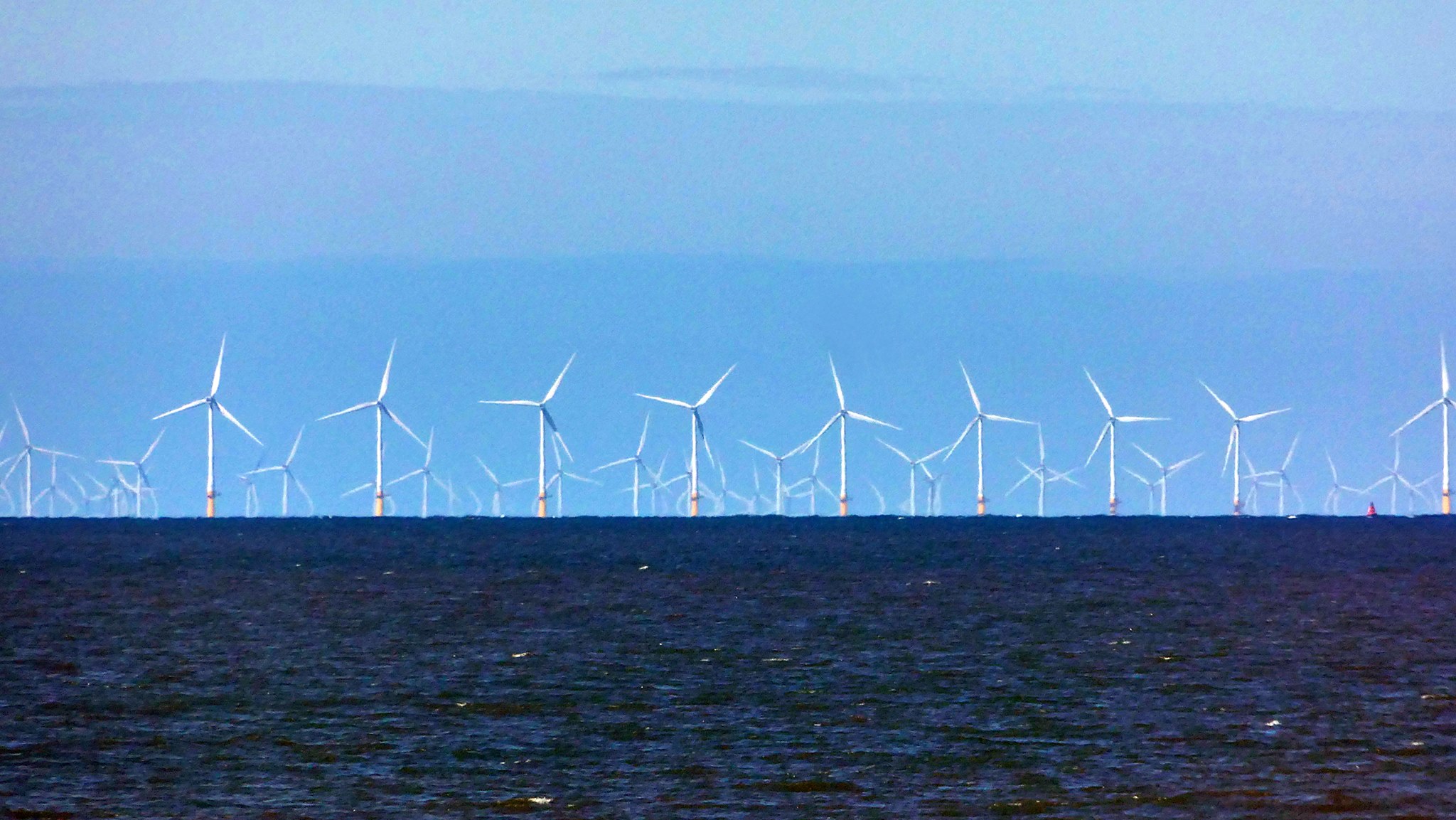
In this vid and pic the yellow bases of the first row of turbines are not obscured. The eye level seems to be pretty close to the surface. I would say it's about 2m.
With an eye height of 2m, the horizon should be at 5.5 km. This means that according to the spheroid Earth's curve formula.......this pic must then have been taken within this 5.5 km distance.
Now you present this as evidence of the curvature of the Earth by pointing out that the turbines that are further away, in the second row, are being "cut off" from the bottom because they are being obscured by the curvature horizon.
Ok, so what is the distance between these rows?
The turbines are 749m-958m apart and installed in rows.
www.power-technology.com...
So the second row must then be within 6.5 km at which point you would get a hidden height of.........0.07 meters, aka 7cm.
These second row shafts, of 137 or 150 m high turbines(from bottom to blade tip) are almost being cut in half by the curvature you say?
When it should only be 7 cm?
Oops.
Again the supposed curvature fails.
At 7.5 km the hidden height would be 0.28 m. for the third row.
At 8.5 km it would be 0.62 m. for the fourth row.
It doesn't really matter what exact eye height and distance you take, with the max distances involved here, there simply isn't a large enough amount of drop across 1 km of surface to cut off almost half of the shaft of such a turbine, while leaving another turbine, 1 km closer, "untouched". Not even close.
However, the shot is probably taken from a further distance but according to Globe Earth math, the shot must have been taken within in 5.5 km of that first row of turbines, since they are not, or not noticably obscured by the horizon. If it was taken from much further away then at least the stretch between the camera and the first row of turbines, must be flat........
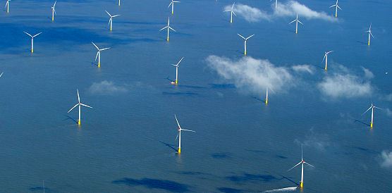
I like that Youtuber's comment in the vid description.
Exceptional clarity to view the windfarm as it drops over the horizon 22 miles away.
The horizon seems to be exactly at the base of the first row of turbines. If that is 22 miles away, then let me help you, at 22 miles, and a 2 m eyeheight, there should be a hidden height of 60m or about 200 ft.
We don't see any drop there. Nothing is obscured. If anyone wants to argue that I have the eye height wrong, and that it is much higher, then you will have the problem that the second row should not, or hardly be obscured either, it is only a km further away, and the third row is only 2 km further.
If you want to argue that he meant that the second row is at 22 miles, then the first row is still at 21 plus miles and the first row should still be obscured for a large part, but it isn't at all.
www.metabunk.org...
Conclusion, whatever it is that causes those views in the vid and the pic, is not a result of the supposed Earth curvature, there is no drop at all where there should be quite a lot, or there is way too much of it where it shouldn't be.(that much)
Take your pick.
The stuff you presented here as proof for a Globe Earth with a circumference of 24,901 miles, along with the supposed Globe Earth curvature math, actually disproves this belief.
Added this,
The turbines are 749m-958m apart and installed in rows.
because it dissapeared from the qoute.
edit on 6-6-2017 by BloatedSpheroid because: (no reason given)
I am fully willing to admit that many aspects of the Flat Earth don't work. Will you admit that many aspects of globe Earth don't work? Because they
don't like I keep showing. I am not sure what our reality is, but it doesn't work being a globe of 24,901 miles in circumference either.
And regarding claims of "obfuscation", yah, the truth sure is confusing. The only reason you accuse me of trying to "obfuscate" things is because I am blowing your mind and you have no (intellectually honest)way of dealing with it.
And regarding claims of "obfuscation", yah, the truth sure is confusing. The only reason you accuse me of trying to "obfuscate" things is because I am blowing your mind and you have no (intellectually honest)way of dealing with it.
edit on 6-6-2017 by BloatedSpheroid because: (no reason given)
a reply to: BloatedSpheroid
I don't need to debunk you. It's been debunked for rather a longish amount of time. As you well know.
I don't need to debunk you. It's been debunked for rather a longish amount of time. As you well know.
a reply to: seagull
You cannot debunk my post because it is completely factual and based on your own ball Earth math. You make all sorts of unfounded accusations and you are totally inept when it comes to formulating a relevant response that is of substance.
Meanwhile my analysis remains untouched. Whatever you post is totally irrelevant.
edit on 6-6-2017 by BloatedSpheroid because: (no reason given)
a reply to: BloatedSpheroid
Irrelevant? This from the guy who insists the Earth is flat?
Pardon me while I point and laugh. If you can't be bothered to do your own research I'll be darned if I'm going to do it for you.
Maybe in your next incarnation, or between 'em, you can actually do a little homework yourself, rather than trot out the same stupidity each and every time.
Irrelevant....
edit on 6/6/2017 by seagull because: (no reason given)
a reply to: seagull
I did my research. I wrote a substantial post on it, fully sourced and supported by accepted math. Reposted it 2 times.
You are the one accusing me of posting falsehoods and deliberate obfuscation. Since you are unwilling, read unable, to back up those accusations, it is safe to say that your posts are totally irrelevant, and completely pathetic.
Pardon me while I point and laugh. If you can't be bothered to do your own research I'll be darned if I'm going to do it for you.
I did my research. I wrote a substantial post on it, fully sourced and supported by accepted math. Reposted it 2 times.
You are the one accusing me of posting falsehoods and deliberate obfuscation. Since you are unwilling, read unable, to back up those accusations, it is safe to say that your posts are totally irrelevant, and completely pathetic.
a reply to: seagull
First explain why the first row is not obscured at all.
Then explain why the second row is obscured by that much. You have been given all the info and tools needed to come up with a ball Earth explanation. If you can't then ball Earth has a problem.
First explain why the first row is not obscured at all.
Then explain why the second row is obscured by that much. You have been given all the info and tools needed to come up with a ball Earth explanation. If you can't then ball Earth has a problem.
edit on 6-6-2017 by BloatedSpheroid because: (no reason given)
a reply to: BloatedSpheroid
already shown - your inability to accept it is your problem
the distance between row one > 2 is far greater than the distance between row 2 > 3
already shown - your inability to accept it is your problem
the distance between row one > 2 is far greater than the distance between row 2 > 3
edit on 6-6-2017 by ignorant_ape because: (no reason
given)
a reply to: BloatedSpheroid
and it wasnt actually addressng what ATS member wildespace wrote - was it - ???
so much for intulectual honesty
and it wasnt actually addressng what ATS member wildespace wrote - was it - ???
so much for intulectual honesty
Roses are red
Violets are blue
The Earth is flat
And so is your thread.
Violets are blue
The Earth is flat
And so is your thread.
and global peace returns .............. untill the next sock puppet spawns
originally posted by: BloatedSpheroid
a reply to: network dude
I care not for all the math involved in this,
Then don't interfere in a discussion that is based on this math.
I just want to see the edge and I'll straight up believe you.
I care not about your wishes. The discussion is about the Earth's curvature formula not applying to reallife observations.
If you can't show an edge, then there likely isn't one. I'm sorry I don't want to dazzle everyone with pseudo bull#, I'm a relist. If it's flat, show me an edge, any of them. If you can do that, you win, if not, you lost.
Now go to the beach and watch a ship disappear.
edit on 6-6-2017 by network dude because: bad spler
ok - now that the latest incarnation of our flat-tard troll has been banned again - iits a good idea to look carefully at iits latest claims , because
iits hysterical , and boiled down to :
" the earth is too curved "
you really cannot make this up - at least not with a straight face
this level of anti-science - pretty much defiines the flat earth cult - it doesnt matter weather thier claim is logical , consistent or fits other observatiions - they just spew out their opinion as fact
its especially funny - as previous iincarnations of the troll - claimed that " obvservations " of iislands " prooved " that there was no curvature
let the last 3 pages be a lesson
Everything just has to be explained pixel by pixel doesn't it, even though it was all there initially. It just doesn't, or won't register.
Your straw man arguments don't even touch the issue, even if they were actually correct and true.
Let's start from the second row of turbines then, the row you claim is much further away than 1 km. from the first row. So how much further away is it according to you?
If the turbines are either 137 m, or 150 tall from the bottom to the blade tip, then we can see that the second row is obscured by about one third of that height, 46 or 50 m.
www.metabunk.org...
If we then use the Earth curve calculator that is based on the spherical mathematics of a globe with a circumference of 24,901 miles, and look for a hidden height of 50 m, using a 2m eyeheight we get,
(rounded numbers)
a distance of 33 km from the camera to the second row
a horizon that is at 5.5 km
Oops!
Since we can clearly see that the first row is not beyond the horizon it must be within that 5.5 km distance from the camera.
This then means that there must be a 27.5 km distance between the first and the second row.
So according to you, Walney Wind Farm consists of a single row of turbines, then 27.5 km of nothing, and then more rows that are much closer to one and other and normally spaced?
We all know this is BS and that your supposed argument falls apart here.
But hey, let's try another eye height for good measure.
www.metabunk.org...
Let's say the camera was at 10 m.
Then you would get,
a distance of 39.5 km
a horizon at a distance of 12 km
That would put the first row and the second row........ 27.5 km apart.
We all still know that is BS. Do you see a pattern here?
I can go on all day using different eye heights and distances and even allowing large margins of error regarding my estimated hidden height of the second row, and you still can not explain this view with the supposed curvature, unless you are truly going to argue that there is a 27.5 km distance between the apparently random, lone first row and the rest of the wind farm.
That's it, in order to make this observation work with the universally accepted spherical mathematics of globe Earth with a circumference of 24.901 miles, you have to accept that there must be a 27.5 km distance between the first and second row, which is not true according to photographic evidence, official commentary, and common sense. Nothing has been posted to support such a ridiculous notion and nothing will be because it is complete BS.
You can't make this work with the Earth's supposed curvature and all of this had been explained already, initially.
It probably still doesn't register now, be it on purpose or due to genuine comprehension problems.
All you have to do to settle this issue once and for all is give me an eyeheight and a distance that put the first row of turbines within the distance to the horizon, give the second row a drop of about 50 m, and put the first and second row a realistic distance apart, not a ridiculous 27.5 km, or any distance of such a magnitude that would be supported by nothing but wishful thinking and fantasy.
You simply can't. You will respond with the usual empty drivel but you will not touch the issue and the math. It's over. The curvature does not add up with this, and many other observations.
Here, once more, the link to the calculator. And if you are going to argue that I got any variable wrong, then make it work with what you think the values should be, go right ahead and debunk the issue using ball Earth math.
www.metabunk.org...
No amount of strawman arguments are going to change the fact that the curvature formula doesn't work in the cases that were presented as proof of curvature, regardless of what the shape of the Earth might be.
They were a lesson, you got schooled here. But somehow I think you didn't pick up anything, just like that time in elementary school when they were teaching you spelling and punctuation and such.
You think you are better than everyone, that rules of written communication don't apply to you? Just the appearance of your posts alone is an insult to intellectuality in general.
Your straw man arguments don't even touch the issue, even if they were actually correct and true.
Let's start from the second row of turbines then, the row you claim is much further away than 1 km. from the first row. So how much further away is it according to you?
Walney is constructed along a north-west to south-east direction. It covers an area of approximately 73km². Walney I and II each have 51 Siemens turbines with a rated capacity of 3.6MW. The turbines are 749m-958m apart and installed in rows. Turbines installed at Walney I have a rotor diameter of 107m and are 137m tall, to the tip of the blade. Walney II has turbines with a rotor diameter of 120m. The turbines have a maximum height of 150m to the tip of the blade.
If the turbines are either 137 m, or 150 tall from the bottom to the blade tip, then we can see that the second row is obscured by about one third of that height, 46 or 50 m.
www.metabunk.org...
If we then use the Earth curve calculator that is based on the spherical mathematics of a globe with a circumference of 24,901 miles, and look for a hidden height of 50 m, using a 2m eyeheight we get,
(rounded numbers)
a distance of 33 km from the camera to the second row
a horizon that is at 5.5 km
Oops!
Since we can clearly see that the first row is not beyond the horizon it must be within that 5.5 km distance from the camera.
This then means that there must be a 27.5 km distance between the first and the second row.
So according to you, Walney Wind Farm consists of a single row of turbines, then 27.5 km of nothing, and then more rows that are much closer to one and other and normally spaced?
We all know this is BS and that your supposed argument falls apart here.
But hey, let's try another eye height for good measure.
www.metabunk.org...
Let's say the camera was at 10 m.
Then you would get,
a distance of 39.5 km
a horizon at a distance of 12 km
That would put the first row and the second row........ 27.5 km apart.
We all still know that is BS. Do you see a pattern here?
I can go on all day using different eye heights and distances and even allowing large margins of error regarding my estimated hidden height of the second row, and you still can not explain this view with the supposed curvature, unless you are truly going to argue that there is a 27.5 km distance between the apparently random, lone first row and the rest of the wind farm.
That's it, in order to make this observation work with the universally accepted spherical mathematics of globe Earth with a circumference of 24.901 miles, you have to accept that there must be a 27.5 km distance between the first and second row, which is not true according to photographic evidence, official commentary, and common sense. Nothing has been posted to support such a ridiculous notion and nothing will be because it is complete BS.
You can't make this work with the Earth's supposed curvature and all of this had been explained already, initially.
It probably still doesn't register now, be it on purpose or due to genuine comprehension problems.
All you have to do to settle this issue once and for all is give me an eyeheight and a distance that put the first row of turbines within the distance to the horizon, give the second row a drop of about 50 m, and put the first and second row a realistic distance apart, not a ridiculous 27.5 km, or any distance of such a magnitude that would be supported by nothing but wishful thinking and fantasy.
You simply can't. You will respond with the usual empty drivel but you will not touch the issue and the math. It's over. The curvature does not add up with this, and many other observations.
Here, once more, the link to the calculator. And if you are going to argue that I got any variable wrong, then make it work with what you think the values should be, go right ahead and debunk the issue using ball Earth math.
www.metabunk.org...
No amount of strawman arguments are going to change the fact that the curvature formula doesn't work in the cases that were presented as proof of curvature, regardless of what the shape of the Earth might be.
let the last 3 pages be a lesson
They were a lesson, you got schooled here. But somehow I think you didn't pick up anything, just like that time in elementary school when they were teaching you spelling and punctuation and such.
You think you are better than everyone, that rules of written communication don't apply to you? Just the appearance of your posts alone is an insult to intellectuality in general.
edit on 7-6-2017 by CrushingFootSoldiers because: (no reason given)
a reply to: wildespace
Any thoughts on the multiple posts directed at you regarding your claims of proof of curvature?
I mean really, this is the best of debunking that ATS has to offer? This joke, this disgrace, is ATS' "voice of reason" and the representative of its intellectual conscience?
You rely on a semi illiterate ignorant ape to save your model? Well he failed miserably.
I know you can't be satisfied with his "debunking" of the issues here.
First of all, sorry for not getting back to this thread sooner. I usually hang around the Space Exploration forum, and rarely visit any other ATS
forums.
Just wanted to share this video, where rationalists/debunkers discuss the Flat Earth beliefs and believers:
www.youtube.com...
Just wanted to share this video, where rationalists/debunkers discuss the Flat Earth beliefs and believers:
www.youtube.com...
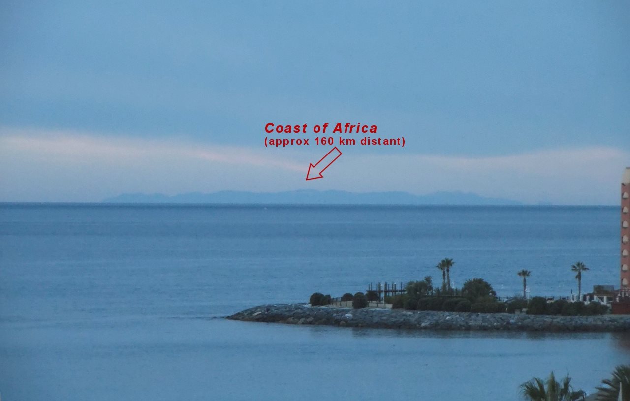
originally posted by: SphereChuckers
a reply to: wildespace
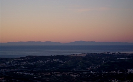
When in Spain, I could see North African mountains on the horizon, but where is the rest of North African coast?
Another interesting question would be, "why can I even see this much of the mountains"? I agree that there is a phenomenon that is obscuring the lowest parts of the coast but there are other issues here.
The distance to the African coast is 160 km. Judging from the building visible in the pic and estimating the eye level from it, the eye height is about 50 m.
Eye level seems to be 8 storeys up, 8 x 4 m is 32 m plus another 10 m from ground to sea level is 42 m. Let's make this 50 m, I think it is actually lower, there is no way it is much higher anyway.
At an eye height of 50 m and a distance of 160 km, the hidden height would be 1119 m.
www.metabunk.org...
This has been corrected for refraction.
Here is an elevation map of North Africa.
commons.wikimedia.org...:Morocco_Topography.png
As you can see, at 160 km, the highest visible peaks are around 2000 m high. It must be that mountain range nearest to the coast, because the mountains further away would be totally hidden by curvature, even though they are higher. So the part of the mountains we can see here should be 880m, max.
You really think you are seeing the top 880 m of 2000m high mountains there? It could be, but that looks out of proportion to me.
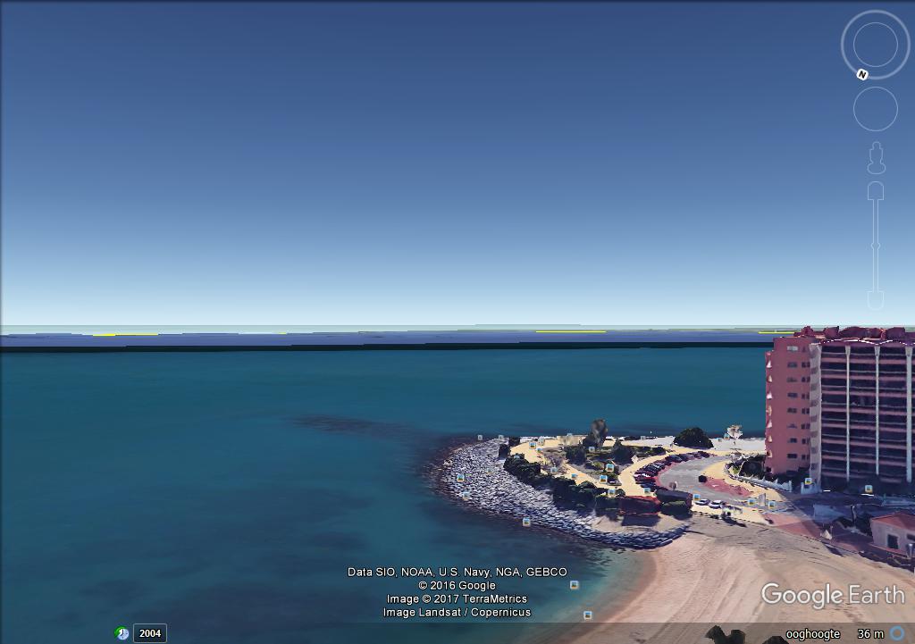
After I typed the above I decided to look for the location just by scrolling along the Spanish coast on GE, and I found it.
Coordinates,
N 36 34949
W 32 32057
GE gives an eye height of 37 m here, and this looks even higher than in the pic, it was probably taken from a hotel balcony.
I'll just stick to the 50 m eye height.
From this location the distance to the African coast is almost exactly 160 km. Those mountains are not located directly at the coast however. On the elevation map we can see that highest, 2000 m tops are AT LEAST 30 km inland.
So, a distance of 190 km with a generous eye height of 50 m would give a hidden height of 1781 m, this means that the part of the mountains we can see in the pic would be only 220 m. We all know that is not what we really see here.
At some points those mountains are actually 200 km away and you shouldn't be able to see them at all from that location.
Where's the curvature? Sure the very lowest parts are being obscured but this is probably due to atmospheric phenomena, not the supposed Earth curvature which I just debunked.
What are your excuses? Refraction? Already accounted for. So the only excuse you guys have left is...... "Mirage!".....
Which is ridiculous, since this view is always visible and that would be one persistent and stable mirage........
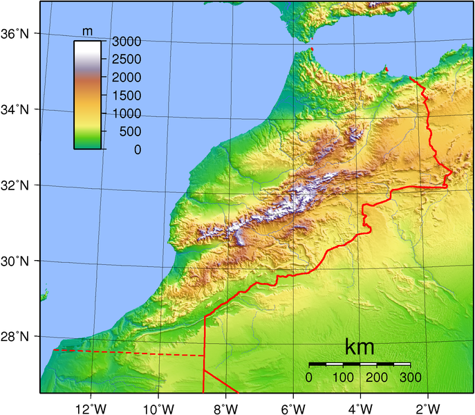
Just for the record, these are the Rif mountains, the highest point of which is almost 2.5 km tall: en.wikipedia.org...
I can see the mountains from that approximate position in Google Earth just fine:
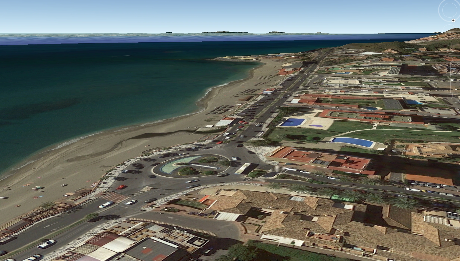
Also, using the Ruler tool in Google Earth shows the distance from Benalmadena and well into the mountains as 160 km, not 190 or more:
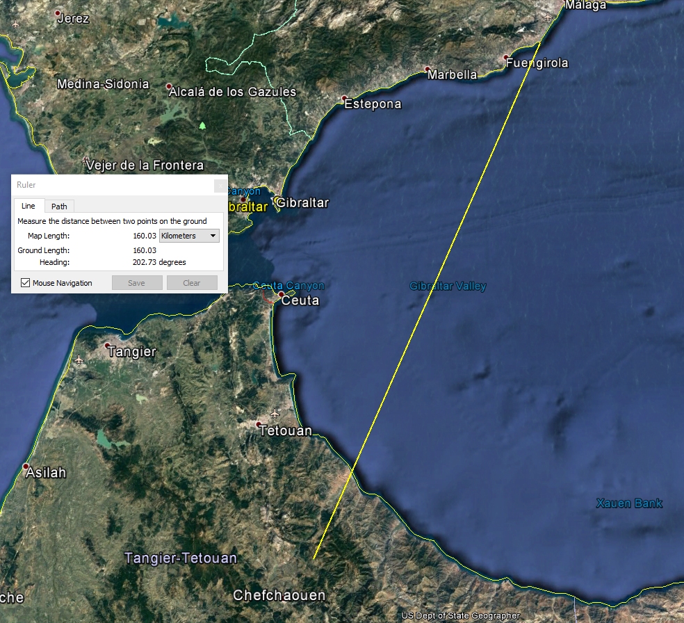
The mountains actually start at around 140 to 150 km distance. 150 km gives the hidden height of 1.34 km, and most of those mountains reach into 1.5 km and towards 2 km.
I'll agree that the visiblity of mountains in my photo might be greater than it usually is, but I'll attribute that to the fact that the mountains become visible on days when there is cool wind blowing from the North. Cooler wind has greater density than warmer air, and denser air creates stronger refraction.
You can see a lot more of those mountains from a nearby mountain in Benalmadena, which, *shock horror* only supports the round earth model:
edit on 11-6-2017 by wildespace because: (no reason given)
new topics
-
President BIDEN's FBI Raided Donald Trump's Florida Home for OBAMA-NORTH KOREA Documents.
Political Conspiracies: 1 hours ago -
Maestro Benedetto
Literature: 3 hours ago -
Is AI Better Than the Hollywood Elite?
Movies: 3 hours ago -
Las Vegas UFO Spotting Teen Traumatized by Demon Creature in Backyard
Aliens and UFOs: 7 hours ago -
2024 Pigeon Forge Rod Run - On the Strip (Video made for you)
Automotive Discussion: 7 hours ago -
Gaza Terrorists Attack US Humanitarian Pier During Construction
Middle East Issues: 8 hours ago -
The functionality of boldening and italics is clunky and no post char limit warning?
ATS Freshman's Forum: 9 hours ago -
Meadows, Giuliani Among 11 Indicted in Arizona in Latest 2020 Election Subversion Case
Mainstream News: 9 hours ago -
Massachusetts Drag Queen Leads Young Kids in Free Palestine Chant
Social Issues and Civil Unrest: 10 hours ago -
Weinstein's conviction overturned
Mainstream News: 11 hours ago
top topics
-
President BIDEN's FBI Raided Donald Trump's Florida Home for OBAMA-NORTH KOREA Documents.
Political Conspiracies: 1 hours ago, 13 flags -
Krystalnacht on today's most elite Universities?
Social Issues and Civil Unrest: 13 hours ago, 9 flags -
University of Texas Instantly Shuts Down Anti Israel Protests
Education and Media: 15 hours ago, 8 flags -
Supreme Court Oral Arguments 4.25.2024 - Are PRESIDENTS IMMUNE From Later Being Prosecuted.
Above Politics: 13 hours ago, 8 flags -
Gaza Terrorists Attack US Humanitarian Pier During Construction
Middle East Issues: 8 hours ago, 7 flags -
Weinstein's conviction overturned
Mainstream News: 11 hours ago, 7 flags -
Massachusetts Drag Queen Leads Young Kids in Free Palestine Chant
Social Issues and Civil Unrest: 10 hours ago, 7 flags -
Meadows, Giuliani Among 11 Indicted in Arizona in Latest 2020 Election Subversion Case
Mainstream News: 9 hours ago, 5 flags -
Las Vegas UFO Spotting Teen Traumatized by Demon Creature in Backyard
Aliens and UFOs: 7 hours ago, 4 flags -
2024 Pigeon Forge Rod Run - On the Strip (Video made for you)
Automotive Discussion: 7 hours ago, 3 flags
active topics
-
Is AI Better Than the Hollywood Elite?
Movies • 11 • : rickymouse -
Supreme Court Oral Arguments 4.25.2024 - Are PRESIDENTS IMMUNE From Later Being Prosecuted.
Above Politics • 83 • : Sookiechacha -
President BIDEN's FBI Raided Donald Trump's Florida Home for OBAMA-NORTH KOREA Documents.
Political Conspiracies • 3 • : xuenchen -
Sol Et Luna - TIME2024
Short Stories • 10 • : BrotherKinsMan -
University of Texas Instantly Shuts Down Anti Israel Protests
Education and Media • 263 • : cherokeetroy -
Massachusetts Drag Queen Leads Young Kids in Free Palestine Chant
Social Issues and Civil Unrest • 13 • : ToneD -
Gaza Terrorists Attack US Humanitarian Pier During Construction
Middle East Issues • 26 • : nugget1 -
British TV Presenter Refuses To Use Guest's Preferred Pronouns
Education and Media • 168 • : Annee -
Manly P. Hall says Freemasonry is a religion?
Secret Societies • 22 • : Therealbeverage -
One Flame Throwing Robot Dog for Christmas Please!
Weaponry • 11 • : Therealbeverage