It looks like you're using an Ad Blocker.
Please white-list or disable AboveTopSecret.com in your ad-blocking tool.
Thank you.
Some features of ATS will be disabled while you continue to use an ad-blocker.

Google Earth - Antarctica Oddities on New Layer? (bottom half reposted from New User forum)
page: 2share:
originally posted by: MarioOnTheFly
a reply to: Phage
But the people who faked his diary were.
Just asking...was there a conclusive evidence that it was faked ? wouldnt mind reading that, to put it to rest.
If you can't separate fantasy from reality, I can't help you.
a reply to: Phage
No can do.
The latest Google Earth program update shows that the north pole no longer exists... it's all melted away and there's nothing to look at but the Arctic Ocean up there. Even Santa's pole has disappeared into the deep blue seas.
By gawd, it's all gone !
Want some fun? Check out the north pole.
No can do.
The latest Google Earth program update shows that the north pole no longer exists... it's all melted away and there's nothing to look at but the Arctic Ocean up there. Even Santa's pole has disappeared into the deep blue seas.
By gawd, it's all gone !
a reply to: Phage
I'll take either one. Dont get defensive here man...I red the thing and however fantastic it sounds...I'm not convinced of it's authenticity. It would be good to see some evidence on it...whatever the result.
It's just that...sometimes this evidence seems contrived to me...often dependent on a statement by someone from the government.
a reply to: MarioOnTheFly
You might start by looking into the things that are known about the expedition before considering the fantastical claims about it.
You might start by looking into the things that are known about the expedition before considering the fantastical claims about it.
edit on 10/6/2016 by Phage because: (no reason given)
a reply to: androal
Lake Vostok is interesting in itself. Our scientists on Ross island study geology, paleontology marine and coastal biology. It is perfect place for finding meteorites (almost every stone on snow is meteorite there ) Polar area have unique geomagnetic and weather properties so some astronomical experiments are placed there. There is lot to study but almost nothing of interest for ordinary Joe.
Lake Vostok is interesting in itself. Our scientists on Ross island study geology, paleontology marine and coastal biology. It is perfect place for finding meteorites (almost every stone on snow is meteorite there ) Polar area have unique geomagnetic and weather properties so some astronomical experiments are placed there. There is lot to study but almost nothing of interest for ordinary Joe.
edit on 6-10-2016 by JanAmosComenius
because: (no reason given)
a reply to: CranialSponge
i thought the North pole just disappeared in its summer months, could be wrong though...
i thought the North pole just disappeared in its summer months, could be wrong though...
a reply to: Phage
I've done some extensive reading on Admiral Byrd,all his appearances on talk shows etc,he seems to verify what was in his diary's and now for 1st time I hear it was all made up? sounds like someone checked Google again,googling with get you whatever the govt wants you to hear,wake up try learning the old way,by doing research
I've done some extensive reading on Admiral Byrd,all his appearances on talk shows etc,he seems to verify what was in his diary's and now for 1st time I hear it was all made up? sounds like someone checked Google again,googling with get you whatever the govt wants you to hear,wake up try learning the old way,by doing research
a reply to: Oldtimer2
Am I the only one who's hair begins to stand up on the back of my neck when I learn that the co-founder of google is a russian born Jewish man who's mother is a "researcher" at NASA's Goddard Space Flight Center, and who purchased (long term leased) the Mofett Federal Airfield in silicon valley to park his customized Boeing 767-200 (modified by NASA)?
These are the same people who now control 70% of all internet searches (microsoft and yahoo are responsible for the remaining 29%), between the three top search engines, they've got 99% of the search market.
It's like the inmates are running the asylum.
Between google and facebook, seems like the new military industrial complex yet again has a lock on this one.
I don't have the answers, and I do think alot of its just human nature. It's our own fault - we're creatures of habit, so over time it makes sense that we'd gravitate to one search engine and one social media site. Still, we're giving our minds to them without even lifting a finger to put up a fight.
Within another few decades or so, we won't even be able to tell when history has been re-written (again), and they'll be able to essentially make up any story they want and 99% of the world will believe it - come to think of it, that's kinda already happening now! I verified it on a google search, it must be true!
sounds like someone checked Google again,googling with get you whatever the govt wants you to hear
Am I the only one who's hair begins to stand up on the back of my neck when I learn that the co-founder of google is a russian born Jewish man who's mother is a "researcher" at NASA's Goddard Space Flight Center, and who purchased (long term leased) the Mofett Federal Airfield in silicon valley to park his customized Boeing 767-200 (modified by NASA)?
These are the same people who now control 70% of all internet searches (microsoft and yahoo are responsible for the remaining 29%), between the three top search engines, they've got 99% of the search market.
It's like the inmates are running the asylum.
Between google and facebook, seems like the new military industrial complex yet again has a lock on this one.
I don't have the answers, and I do think alot of its just human nature. It's our own fault - we're creatures of habit, so over time it makes sense that we'd gravitate to one search engine and one social media site. Still, we're giving our minds to them without even lifting a finger to put up a fight.
Within another few decades or so, we won't even be able to tell when history has been re-written (again), and they'll be able to essentially make up any story they want and 99% of the world will believe it - come to think of it, that's kinda already happening now! I verified it on a google search, it must be true!
originally posted by: Oldtimer2
a reply to: Phage
I've done some extensive reading on Admiral Byrd,all his appearances on talk shows etc,he seems to verify what was in his diary's and now for 1st time I hear it was all made up? sounds like someone checked Google again,googling with get you whatever the govt wants you to hear,wake up try learning the old way,by doing research
Talk shows? He died in 1957. What talk shows was he on?
Yes. His nephew allegedly released his "secret" diary. It's fake.
edit on 10/6/2016 by Phage because: (no reason given)
a reply to: CranialSponge
Yeah, I found this contradicting evidence too.
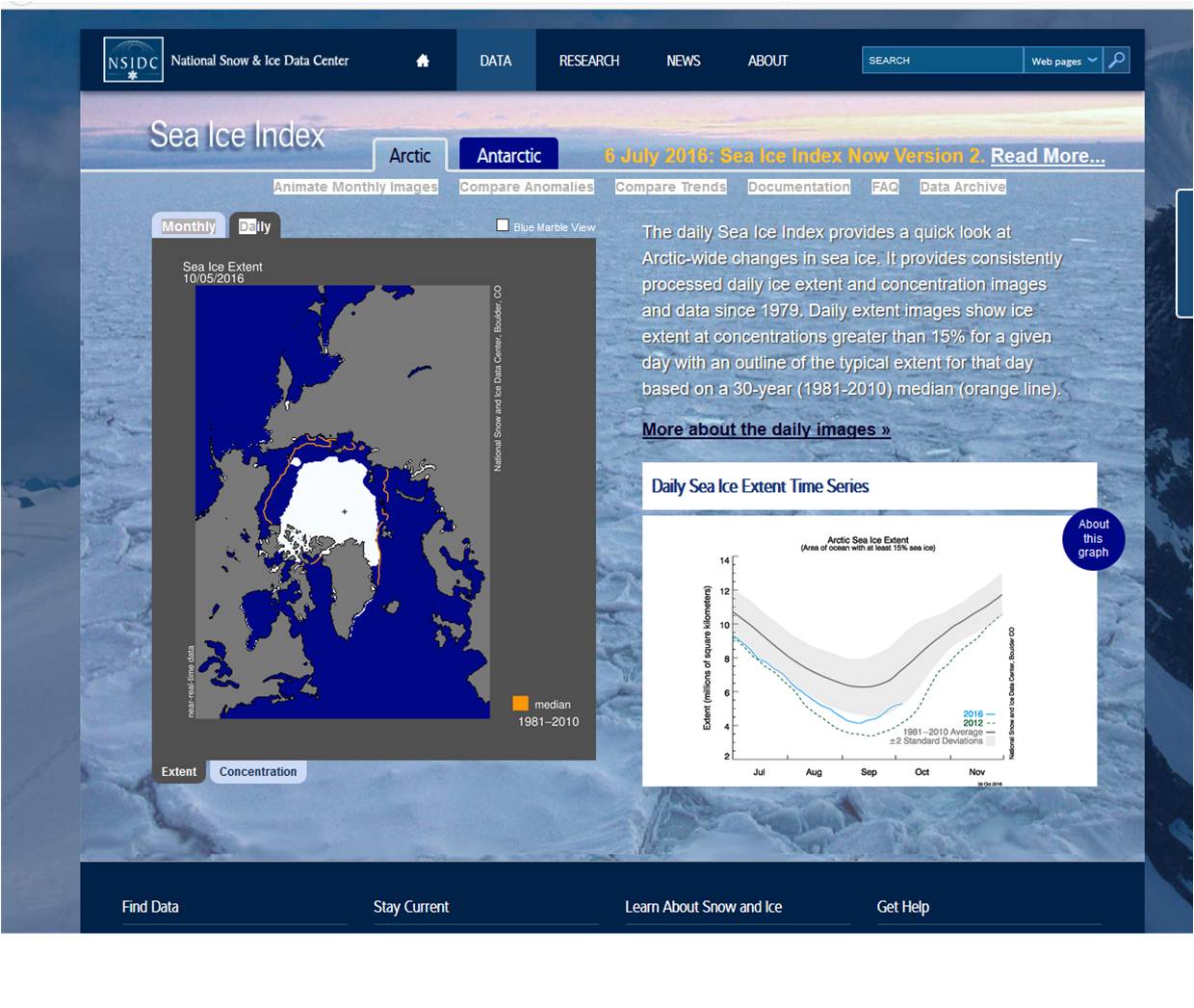
Its from the National Snow & Ice Data Center, data seems reliable(ish).
nsidc.org...
This has daily data and shows the snowmelt of north pole ice region over time (see graph in lower right corner)
Theres definitely ice there. You can see it in the image with near-realtime data as of yesterday.
Looks like less than average (the median orange outline), but definitely iced up.
They also cite the polar hole issue, though they're research shows that the polar hole issue in the south pole region isn't nearly as big of a hole as the antarctic map is currently displaying om google earth.
Strange no one seems to say much about no ice cap whatever on the google earth. I guess its just become common knowledge that the entire ice cap of the north pole completely melts every October?
Yeah, I found this contradicting evidence too.
Its from the National Snow & Ice Data Center, data seems reliable(ish).
nsidc.org...
This has daily data and shows the snowmelt of north pole ice region over time (see graph in lower right corner)
Theres definitely ice there. You can see it in the image with near-realtime data as of yesterday.
Looks like less than average (the median orange outline), but definitely iced up.
They also cite the polar hole issue, though they're research shows that the polar hole issue in the south pole region isn't nearly as big of a hole as the antarctic map is currently displaying om google earth.
Strange no one seems to say much about no ice cap whatever on the google earth. I guess its just become common knowledge that the entire ice cap of the north pole completely melts every October?
edit on 6-10-2016 by androal because: (no reason given)
edit on 6-10-2016 by androal because: (no reason
given)
edit on 6-10-2016 by androal because: (no reason given)
edit on 6-10-2016 by androal because: (no reason
given)
edit on 6-10-2016 by androal because: (no reason given)
a reply to: androal
Native Google Earth shows no sea ice. Anywhere. You know the images are not real time.
But you can get the overlays.
nsidc.org...
Strange no one seems to say much about no ice cap whatever on the google earth. I guess its just become common knowledge that the entire ice cap of the north pole completely melts every October?
Native Google Earth shows no sea ice. Anywhere. You know the images are not real time.
But you can get the overlays.
nsidc.org...
edit on 10/6/2016 by Phage because: (no reason given)
a reply to: Phage
Oh. This is why I love this forum! I was wrong. Thank you!
I did not know that.
Check this out - better Antarctic data than the default that it downloads with?
nsidc.org...
Maybe this is the smoking gun I needed. Did not know this existed. I gotta check this out.
Bingo! Check this out:
nsidc.org...
So this is the image I've been looking for. The south pole ice cap, perfectly rendered (no freaky pyramid thingy emanating light... LOL). So why doesn't google earth use this data?
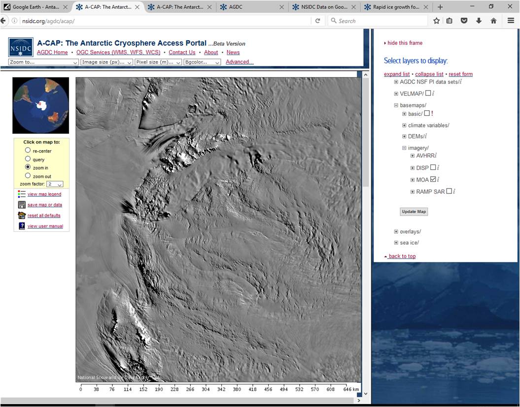
Check this out...
"This DEM is viewable here at a grid scale of 200 m and using a nominal contrast stretch with minimum and maximum WGS84 elevations (m) of -67 and 3600 respectively."
The source went on to cite this has been available since 2008? What am I missing?
So when I download the Google Earth data for the Cryospheric Field Data Set for google earth, this is what I get:
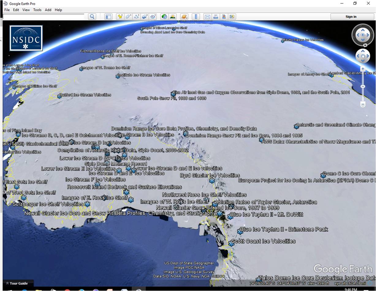
Downloaded from: nsidc.org...
I clicked on a link and it spit out an error message. I sent a help request and am waiting to get feedback.
Is this going to give me an accurate rendering like they have on their website, with the ability to use the elevation tools?
Id love to map my proposed future expedition trip from shore to south pole.
Oh. This is why I love this forum! I was wrong. Thank you!
I did not know that.
Check this out - better Antarctic data than the default that it downloads with?
nsidc.org...
Maybe this is the smoking gun I needed. Did not know this existed. I gotta check this out.
edit on 6-10-2016 by androal because: (no reason
given)
Bingo! Check this out:
nsidc.org...
So this is the image I've been looking for. The south pole ice cap, perfectly rendered (no freaky pyramid thingy emanating light... LOL). So why doesn't google earth use this data?
Check this out...
"This DEM is viewable here at a grid scale of 200 m and using a nominal contrast stretch with minimum and maximum WGS84 elevations (m) of -67 and 3600 respectively."
The source went on to cite this has been available since 2008? What am I missing?
So when I download the Google Earth data for the Cryospheric Field Data Set for google earth, this is what I get:
Downloaded from: nsidc.org...
I clicked on a link and it spit out an error message. I sent a help request and am waiting to get feedback.
Is this going to give me an accurate rendering like they have on their website, with the ability to use the elevation tools?
Id love to map my proposed future expedition trip from shore to south pole.
edit on 6-10-2016 by androal because: (no reason given)
edit on 6-10-2016 by androal because: (no reason
given)
edit on 6-10-2016 by androal because: (no reason given)
originally posted by: MarioOnTheFly
a reply to: Phage
But the people who faked his diary were.
Just asking...was there a conclusive evidence that it was faked ? wouldnt mind reading that, to put it to rest.
As I recall, Byrd's diary was written about a journey to the North Pole.
There are some people that believe it was faked...and he was really at the South Pole when it was written.
Or something like that.
a reply to: androal
No. You will still have the DEM which is native to Google Earth. Overlays are "skins" which are applied over the DEM.
Is this going to give me an accurate rendering like they have on their website, with the ability to use the elevation tools?
No. You will still have the DEM which is native to Google Earth. Overlays are "skins" which are applied over the DEM.
edit on 10/6/2016 by Phage because: (no reason given)
a reply to: JanAmosComenius
Sorry, can't seem to get the quote thing to work on my browser so Im quoting manually...
a reply to: androal
"Lake Vostok is interesting in itself. Our scientists on Ross island study geology, paleontology marine and coastal biology. It is perfect place for finding meteorites (almost every stone on snow is meteorite there
) Polar area have unique geomagnetic and weather properties so some astronomical experiments are placed there. There is lot to study but almost nothing of interest for ordinary Joe."
Yeah, there's so much stuff on the 20million year old lake theories. Id like to start with a comment that Phage made earlier about the way the most current, best rendered tiles are used, and past tiles are available if you want to see them."
Just last week I was able to at least see the lake and the Russian science station. Even had a nice visual of a road or tunnel thing leading all the way to our station. At this point, both station, lake, and road/tunnel thingy are totally gone from both the google earth and google maps versions. This is what I mean when I said the visual updates and smudging out of various artifacts in the pixels is happening.
How do I get the old versions of what the previous images they had up there were? I'm curious to learn more about Lake Volstok. And I would love to get back that road/tunnel I was following on the version I was using last week. Any idea how to do this?
The volstok island in the south pacific is pretty cool too - unfortunately major rendering issues like of Hawaii exist there too. Best visual data is on google maps for this one, elevation data is shoddy at best on google earth, but it does exist to some degree...
Might be best to start a new thread on Volstok. This is getting lengthy. Maybe theres already a Lake Volstok thread started? Do people tag onto old subjects in this forum if they have new info to add?
edit on 6-10-2016 by androal because: (no reason given)
originally posted by: Phage
a reply to: androal
NSIDC Data was 1km back in 2003
Hawaii was 10m or 5m depending on the source (NEXTMap) offers 5m data for a price...
"reply to: androal Big difference, huh? "
I found this: www.pgc.umn.edu...
Arctic DEM to 0.5m has been collected since 2015, it's not clear what precisely is made available for Antarctic. I told you they had it... not sure what exactly they've made available though. Need a research.purpose. any ideas?
I e-mailed the Director - we'll see what he says... I'm not a researcher so its dubious at best that they'd give me access to it. But the answers "no" if you don't ask, so I may as well try!
The image they have on their website would surely give FE guys a kick, right?
edit on 7-10-2016 by androal because: (no reason given)edit on 7-10-2016 by androal because: (no reason given)
a reply to: Phage
Phage, your conclusion about Google Maps / Google earth always defaulting to using the most currently available tiles/image data set, is simply untrue.
"Google tends to use the highest resolution images available, both aerial and satellite. At the poles both aerial and satellite imagery is spotty. Try this, find an area with pretty good resolution and use the timeline feature to look at earlier imagery for the same area, you will see that the older stuff is not as good as the newer stuff."
I just got the response regarding public access to this data from Paul M, director at Polar Geospacial Center:
www.pgc.umn.edu...
Paul confirms there’s no way we're authorized to access the data unless we're associated with an organization funded by the US Government. Funding the US Government as a tax payer is insufficient. He also confirms that google earth/maps is the most reliable and up-to-date source of geospacial data currently available to the public. Not sure I agree with him, I’m still looking.
Consider the link (below) – a sample animation of what was available over twelve years ago. Is anyone else having trouble replicating this kind of imaging with currently available Antarctica mapping data?
svs.gsfc.nasa.gov...
Remember, that animation was done with data available over twelve years ago!
The stated goal of PGC is to make higher resolution (0.5m) data (including elevations) publicly available by 2017. Details for this data on antarctica are less clear, but it is clear that MODIS Mosaic of Antarctica (MOA) and LIMA / MODIS / RADARSTAT Mosaic of Antarctica has been available since 2003-2004.
www.pgc.umn.edu...
I know I’m not alone in having unanswered questions about the availability of certain public assets that we’ve all payed for with our tax dollars. The mapping data I seek is in fact all sourced from publicly funded, non-military, organizations.
Having said this, I co appreciate that the military does have legitimate privacy concerns for certain confidential aspects of satellite imagery that might impact national security interests. But as so many have aptly point out, we’re talking about rocks and penguins after all, right? On a continent governed by non-military treatise.
I might be overly sensitive but the tone of many respondent's to my comments seem to contain sentiment that lacks intellectual integrity. The response sounds like:
“don’t ask such dumb questions, this stuff is waaayyyy toooo complex for people like you to understand. Do your own homework and please stop wasting our time.”
Contradicting this patronizing tone is an opposing, and equally pro-vocational one of:
“This stuff is soooo simple and obvious that a fifth grader gets it. There’s nothing to see in Antarctica than rocks, penguins, and altruistic scientists studying the environment. Move along.”
Perhaps my questions have been too nebulous to elicit a more concise response. Perhaps one day I’ll exhaust of such wearisome concerns over such trivial matters. Until then, I graciously appreciate the forum’s (intellectually honest) response to any of the below (or related) subjects:
ANTARCTICA - 3D MAPPING RESOURCES
1. Where can we get quasi-accurate, publicly available (i.e. current-technology,
new topics
-
President BIDEN's FBI Raided Donald Trump's Florida Home for OBAMA-NORTH KOREA Documents.
Political Conspiracies: 4 hours ago -
Maestro Benedetto
Literature: 5 hours ago -
Is AI Better Than the Hollywood Elite?
Movies: 5 hours ago -
Las Vegas UFO Spotting Teen Traumatized by Demon Creature in Backyard
Aliens and UFOs: 9 hours ago -
2024 Pigeon Forge Rod Run - On the Strip (Video made for you)
Automotive Discussion: 10 hours ago -
Gaza Terrorists Attack US Humanitarian Pier During Construction
Middle East Issues: 10 hours ago -
The functionality of boldening and italics is clunky and no post char limit warning?
ATS Freshman's Forum: 11 hours ago
top topics
-
President BIDEN's FBI Raided Donald Trump's Florida Home for OBAMA-NORTH KOREA Documents.
Political Conspiracies: 4 hours ago, 25 flags -
Krystalnacht on today's most elite Universities?
Social Issues and Civil Unrest: 15 hours ago, 9 flags -
Supreme Court Oral Arguments 4.25.2024 - Are PRESIDENTS IMMUNE From Later Being Prosecuted.
Above Politics: 15 hours ago, 8 flags -
Weinstein's conviction overturned
Mainstream News: 13 hours ago, 8 flags -
Massachusetts Drag Queen Leads Young Kids in Free Palestine Chant
Social Issues and Civil Unrest: 12 hours ago, 7 flags -
Gaza Terrorists Attack US Humanitarian Pier During Construction
Middle East Issues: 10 hours ago, 7 flags -
Las Vegas UFO Spotting Teen Traumatized by Demon Creature in Backyard
Aliens and UFOs: 9 hours ago, 6 flags -
Meadows, Giuliani Among 11 Indicted in Arizona in Latest 2020 Election Subversion Case
Mainstream News: 12 hours ago, 5 flags -
2024 Pigeon Forge Rod Run - On the Strip (Video made for you)
Automotive Discussion: 10 hours ago, 4 flags -
Is AI Better Than the Hollywood Elite?
Movies: 5 hours ago, 3 flags
active topics
-
President BIDEN's FBI Raided Donald Trump's Florida Home for OBAMA-NORTH KOREA Documents.
Political Conspiracies • 16 • : Astyanax -
Truth Social goes public, be careful not to lose your money
Mainstream News • 130 • : Astyanax -
Las Vegas UFO Spotting Teen Traumatized by Demon Creature in Backyard
Aliens and UFOs • 11 • : AwakeNotWoke -
Is AI Better Than the Hollywood Elite?
Movies • 13 • : Justoneman -
Hate makes for strange bedfellows
US Political Madness • 47 • : 19Bones79 -
-@TH3WH17ERABB17- -Q- ---TIME TO SHOW THE WORLD--- -Part- --44--
Dissecting Disinformation • 689 • : daskakik -
University of Texas Instantly Shuts Down Anti Israel Protests
Education and Media • 265 • : Astrocometus -
Gaza Terrorists Attack US Humanitarian Pier During Construction
Middle East Issues • 27 • : ToneD -
Reason of the Existence
The Gray Area • 21 • : BingoMcGoof -
Supreme Court Oral Arguments 4.25.2024 - Are PRESIDENTS IMMUNE From Later Being Prosecuted.
Above Politics • 85 • : Sookiechacha