It looks like you're using an Ad Blocker.
Please white-list or disable AboveTopSecret.com in your ad-blocking tool.
Thank you.
Some features of ATS will be disabled while you continue to use an ad-blocker.

Weird photo near Deception Island (near Antartica) from Google Maps
page: 5share:
a reply to: Bspiracy
I did not, and still do not, see any anomalous lighting. Perhaps you are mistaking color variance for lighting. Please refer again to the aerial image of the rock.
If the question is to cajole an understanding to why an illuminated perimeter on both sides of the bright spots on the island are apparent ..
I did not, and still do not, see any anomalous lighting. Perhaps you are mistaking color variance for lighting. Please refer again to the aerial image of the rock.
originally posted by: Phage
a reply to: Bspiracy
If the question is to cajole an understanding to why an illuminated perimeter on both sides of the bright spots on the island are apparent ..
I did not, and still do not, see any anomalous lighting. Perhaps you are mistaking color variance for lighting. Please refer again to the aerial image of the rock.
I am the one that reposted the aerial image..
Giess ill have to friggin photoshop whay im talking about..
Sheesh.. Gimme a min to illustrate.
B
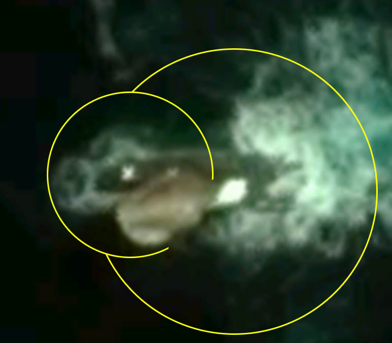
Looks like a smooth surface, and it must be the size of a city block or more.
A lot of turbulence is there indicating great movement on the surface,
Look like a giant stingray. Certainly odd, good find.
I used google earth and simply copy and pasted the coordinates in -
worked fine.
a reply to: saint4God
A lot of turbulence is there indicating great movement on the surface,
Look like a giant stingray. Certainly odd, good find.
I used google earth and simply copy and pasted the coordinates in -
worked fine.
a reply to: saint4God
edit on 18-6-2016 by Drawsoho because: (no reason given)
a reply to: Bspiracy
Aerial:
performed in the air
: performed using an airplane : taken or seen from an airplane
www.merriam-webster.com...
Aerial:
performed in the air
: performed using an airplane : taken or seen from an airplane
www.merriam-webster.com...
edit on 6/18/2016 by Phage because: (no reason given)
oooo kkkk
originally posted by: Phage
a reply to: Bspiracy
Aerial:
performed in the air
: performed using an airplane : taken or seen from an airplane
www.merriam-webster.com...
If thats your narrow view than so be it
B
originally posted by: Bspiracy
oooo kkkk
originally posted by: Phage
a reply to: Bspiracy
Aerial:
performed in the air
: performed using an airplane : taken or seen from an airplane
www.merriam-webster.com...
If thats your narrow view than so be it
B
It's not my view. It's the definition.
Aerial images are from aircraft (from the Greek, aerios). Satellite images are from satellites.
edit on 6/18/2016 by Phage because: (no reason given)
originally posted by: Phage
originally posted by: Bspiracy
oooo kkkk
originally posted by: Phage
a reply to: Bspiracy
Aerial:
performed in the air
: performed using an airplane : taken or seen from an airplane
www.merriam-webster.com...
If thats your narrow view than so be it
B
It's not my view. It's the definition.
Aerial images are from aircraft. Satellite images are from satellites.
Touche'
Sad a person has to refer to a written definition when you know what i said was truth at its generallly undersrood core.. . on this site at least.
You are a brilliant person but others arent so. Meet them in the middle.
Back to the point.
Your "southern sun" doesnt answer the multi faceted illumination issue for me right now. Mabybe after further thought it will
B
a reply to: Bspiracy
I guess you missed it the first time.
Did you see the patch of ice in the aerial image I posted?
The point was to differentiate the satellite image from Google and the aerial image I posted. In general, aerial images show higher levels of detail. In this case, a great deal higher.
Sad a person has to refer to a written definition when you know what i said was truth at its generallly undersrood core.. . on this site at least.
Your "southern sun" doesnt answer the multi faceted illumination issue for me right now. Mabybe after further thought it will
I guess you missed it the first time.
Did you see the patch of ice in the aerial image I posted?
edit on 6/18/2016 by Phage because: (no reason given)
originally posted by: Phage
a reply to: Bspiracy
The point was to differentiate the satellite image from Google and the aerial image I posted. In general, aerial images show higher levels of detail. In this case, a great deal higher.
Sad a person has to refer to a written definition when you know what i said was truth at its generallly undersrood core.. . on this site at least.
Your "southern sun" doesnt answer the multi faceted illumination issue for me right now. Mabybe after further thought it will
I guess you missed it the first time.
Did you see the patch of ice in the aerial image I posted?
Admittedly i dont know what yer talkinng about. I revisited earlier pages and i dont know what you mean. Repost please
IMHO,
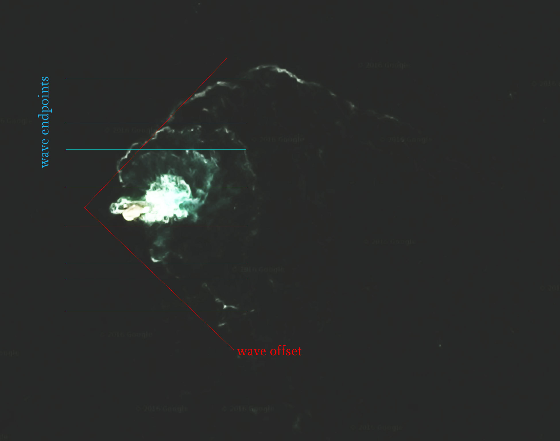
this is clearly a boat, probably a fishing boat with its lights on. Look at the wave fallout/offset, the direction and the wave pattern - i think there is not much room for an alternative explanation
George
this is clearly a boat, probably a fishing boat with its lights on. Look at the wave fallout/offset, the direction and the wave pattern - i think there is not much room for an alternative explanation
George
Sail Rock is an insular rock, 30 m high, lying 7 nautical miles (13 km) southwest of Deception Island, in the South Shetland Islands. This name, which
dates back to at least 1822, was probably given by sealers. From a distance, the rock is reported to resemble a ship under sail, but at close range it
is more like a house with a gable roof.
new topics
-
Ireland VS Globalists
Social Issues and Civil Unrest: 4 minutes ago -
Biden "Happy To Debate Trump"
Mainstream News: 35 minutes ago -
RAAF airbase in Roswell, New Mexico is on fire
Aliens and UFOs: 44 minutes ago -
What is the white pill?
Philosophy and Metaphysics: 2 hours ago -
Mike Pinder The Moody Blues R.I.P.
Music: 2 hours ago -
Putin, Russia and the Great Architects of the Universe
ATS Skunk Works: 6 hours ago -
A Warning to America: 25 Ways the US is Being Destroyed
New World Order: 10 hours ago
top topics
-
President BIDEN's FBI Raided Donald Trump's Florida Home for OBAMA-NORTH KOREA Documents.
Political Conspiracies: 16 hours ago, 34 flags -
A Warning to America: 25 Ways the US is Being Destroyed
New World Order: 10 hours ago, 18 flags -
Mike Pinder The Moody Blues R.I.P.
Music: 2 hours ago, 7 flags -
What is the white pill?
Philosophy and Metaphysics: 2 hours ago, 5 flags -
RAAF airbase in Roswell, New Mexico is on fire
Aliens and UFOs: 44 minutes ago, 4 flags -
Is AI Better Than the Hollywood Elite?
Movies: 17 hours ago, 4 flags -
Biden "Happy To Debate Trump"
Mainstream News: 35 minutes ago, 3 flags -
Putin, Russia and the Great Architects of the Universe
ATS Skunk Works: 6 hours ago, 2 flags -
Maestro Benedetto
Literature: 17 hours ago, 1 flags -
Ireland VS Globalists
Social Issues and Civil Unrest: 4 minutes ago, 0 flags
active topics
-
King Charles 111 Diagnosed with Cancer
Mainstream News • 322 • : Oldcarpy2 -
University of Texas Instantly Shuts Down Anti Israel Protests
Education and Media • 278 • : cherokeetroy -
Gaza Terrorists Attack US Humanitarian Pier During Construction
Middle East Issues • 80 • : Asher47 -
Ireland VS Globalists
Social Issues and Civil Unrest • 0 • : TimBurr -
Biden "Happy To Debate Trump"
Mainstream News • 6 • : KrustyKrab -
New whistleblower Jason Sands speaks on Twitter Spaces last night.
Aliens and UFOs • 73 • : pianopraze -
Meadows, Giuliani Among 11 Indicted in Arizona in Latest 2020 Election Subversion Case
Mainstream News • 27 • : IndieA -
RAAF airbase in Roswell, New Mexico is on fire
Aliens and UFOs • 3 • : Degradation33 -
What is the white pill?
Philosophy and Metaphysics • 14 • : kwaka -
Las Vegas UFO Spotting Teen Traumatized by Demon Creature in Backyard
Aliens and UFOs • 16 • : introufo2