It looks like you're using an Ad Blocker.
Please white-list or disable AboveTopSecret.com in your ad-blocking tool.
Thank you.
Some features of ATS will be disabled while you continue to use an ad-blocker.

Quake Watch 2016
page: 33share:
1 day short of 30 days and KUMAMOTO is showing some
nice even numbers
mag~1= 90
mag3= 800
mag4= 100
mag1= 809
mag2= 2334
mag5= 15
mag6= 2
mag7= 1
total= 4151
total energy released= 1,555,305
Just showing how you can make data fit an argument
If I had picked 30 days the number counts would likely be all odds and evens
Edit: If you hadn't notice I like numbers, there are lots of them when it comes to Japan earthquakes;
Just by chance SW of Kyushu is one earthquake away from the 16th batch of 197 quakes (to fit Bing Maps quota) and now after 181 day is at 3154 events, 997 less the Kumamoto's 4151, which has been running for only 29 days.
But since the SW of Kyushu 5.0 of 6/05/2016 5:11, there have been 504 events (I didn't put that in my blog page)
edit on 0500000013413416 by
muzzy because: (no reason given)
a reply to: ericblair4891
Bald Mountain v Hawthorne v Gerlach-Empire v Brawley-El Centro Timeline vs Magnitude Graph
data from ANSS, Northern California Earthquake Data Center.
Looks like a bunch of scribble, but if you follow the colours it makes sense.
What I see;
Bald Mt and Brawley pretty steady throughout 2016, with the occasional burp (higher magnitudeand or compacted periods).
Bald Mt (Red) showing 2 bunches 1/1 (but may have started in 2015) -11/01 and 13/2-3/3, the trend recently is down in numbers and down in magnitude size (2.22 the largest in May)
Brawley (Yellow) showing 2 bunches (compacted periods 21/4-27/4 and 7/5-13/5, activity is up compared to earlier months, but still reasonably stable.
Hawthorne (Blue) 22/1-14/2 and 21/3-7/4, the second bunch being the 4.26 and aftershocks, not a Swarm as such even though the locations were is two different spots Garfield Hills and Walker Lake. Trend is down in numbers and magnitudes lately.
Gerlach-Empire (Green) two bunches 20/4-30/4 and 4/5-14/5 or could be one together, increasing in magnitude (biggest 3.95 on the 14th)
I just found the ComCat Search page, USGS moved it a year or so ago and I gave up on them, found it again off NCEDC, it seems to have more events, e.g. for Bald Mt Comcat has 502 events versus ANSS 424, so I might run the search areas for the other 3 through ComCat and see what comes out.
I think the ANSS graph shows the basic trends though
further to: muzzy
Another NV, Cal Graph
Bald Mountain v Hawthorne v Gerlach-Empire v Brawley-El Centro Timeline vs Magnitude based on ANSS Comprehensive Catalog (ComCat) data.
earthquake.usgs.gov...
Quite a few more quakes, especially Hawthorne.
Area, (ANSS NCDC), (ANSS ComCat), Difference
Bald, (424), (502), +78
Hawthorne, (1094), (1639), +545
Gerlach/Empire, (240), (257), +17
Brawley/ElCentro, (235), (276), +41
Another NV, Cal Graph
Bald Mountain v Hawthorne v Gerlach-Empire v Brawley-El Centro Timeline vs Magnitude based on ANSS Comprehensive Catalog (ComCat) data.
This comprehensive collection of seismic information will eventually replace the ANSS composite catalog hosted by the Northern California Data Center; however, historic regional seismic network catalogs have not yet been fully loaded.
earthquake.usgs.gov...
Quite a few more quakes, especially Hawthorne.
Area, (ANSS NCDC), (ANSS ComCat), Difference
Bald, (424), (502), +78
Hawthorne, (1094), (1639), +545
Gerlach/Empire, (240), (257), +17
Brawley/ElCentro, (235), (276), +41
edit on 0500000013513516 by muzzy because: not sure what that loop in the Gerlacch-Empire line (green) is about, happens sometimes.
a reply to: AlexanderM
friend probably refers to this one.
USGS
friend probably refers to this one.
M5.4 - 6km W of Iwai, Japan
36.047°N 139.832°E depth=37.5 km (23.3 mi)
Time
2016-05-16 12:23:01 (UTC)
2016-05-16 07:23:01 (UTC-05:00) in your timezone
Times in other timezones
Nearby Places
6.0 km (3.7 mi) W of Iwai, Japan
6.0 km (3.7 mi) SSE of Sakai, Japan
9.0 km (5.6 mi) E of Sugito, Japan
10.0 km (6.2 mi) NE of Kasukabe, Japan
41.0 km (25.5 mi) NNE of Tokyo, Japan
USGS
a reply to: muzzy
Thank you Muzzy. So, Nevada and Mexico are busy, and seem to be getting bu$y. I've already thrown out some theories and until something get bigger, or busier, or there's a new area, there's not much else to note at this moment.
Central America had beer real quiet but popped off a few today.
Mexico has tapered somewhat but those that are are slightly on the bigger side.
I'm watching the North Pacific Rise.
Earthquakes here seem to make other things happen big.
earthquaketrack.com...
Earthquakes here seem to make other things happen big.
earthquaketrack.com...
edit on 16-5-2016 by crappiekat because: sp
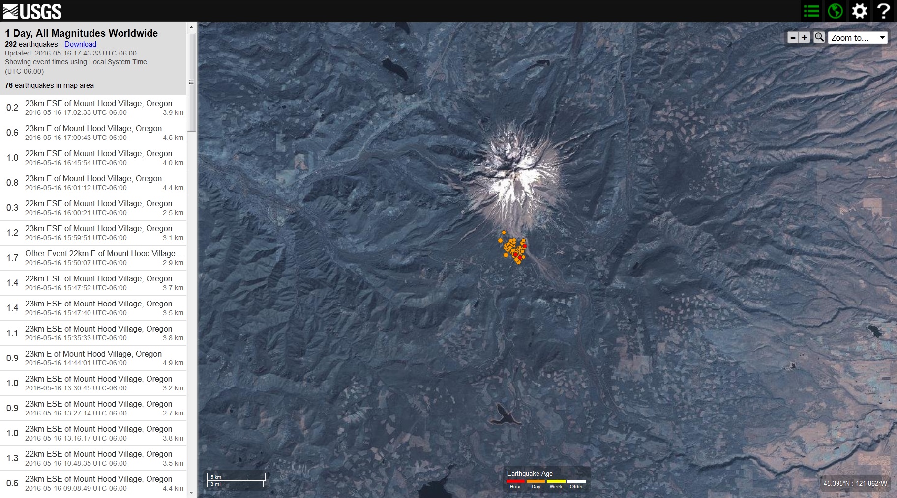
A small EQ swarm has cropped up on the south flank of Mt. Hood, Oregon. So far, 37 very small earthquakes since it began last night.
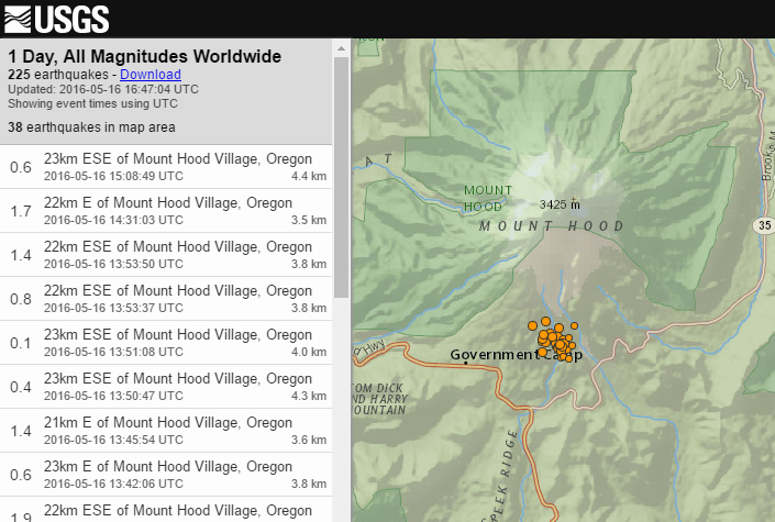
source map
ETA: make that 39 quakes now.
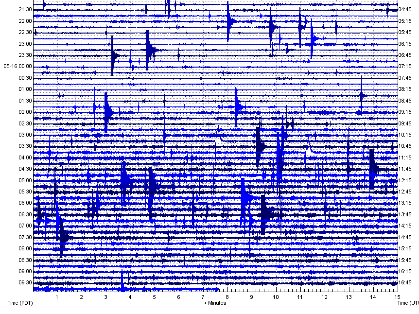
My guess is that the volcano pros will determine this to be tectonic in origin. Here is the link to the PNSN spectrograms for Mt. Hood.
3rd edit:
This link is for a nearby seismometer, TDH, for those interested in following the action.
source map
edit on 5/16/2016 by Olivine because: fix bad link
ETA: make that 39 quakes now.
My guess is that the volcano pros will determine this to be tectonic in origin. Here is the link to the PNSN spectrograms for Mt. Hood.
edit on 5/16/2016 by Olivine because: add
link
3rd edit:
This link is for a nearby seismometer, TDH, for those interested in following the action.

edit on 5/16/2016 by Olivine because: add
another link & pic
edit on 5/16/2016 by Olivine because: (no reason given)
a reply to: crappiekat
Hello CrappieKat! Thanks for the heads up. I think the link is fixed now. They must be adding some very small quakes from last night. The total is now up to 45.
Hello CrappieKat! Thanks for the heads up. I think the link is fixed now. They must be adding some very small quakes from last night. The total is now up to 45.
a reply to: crappiekat
The usgs picture? It's a convoluted process, but this is how I do it:
I zoom into the area of the map I want to show, and then click the "prt sc" (print screen) button along the top of my keyboard.
Then I open Microsoft Paint (or photoshop, etc), and hit the paste button in the top left of the program.
From this point, I can crop it to the dimensions I'd like, and then save the image in my picture files.
Finally, I open the upload page here at ATS, and upload the image.
I hope that helps.
The link is really long on the USGS map page. Just make sure you copy the entire string. That's why my first attempt didn't work; I had cut off the end characters.
edit on 5/16/2016 by Olivine because: (no reason given)
edit on 5/16/2016 by Olivine because:
clarifying
a reply to: lurksoften
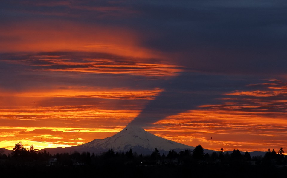
Sweet! Thank you, Lurksoften. Saving the link. It's a shame it is as dreary at Mt. Hood as it was here in Tacoma this morning. Hopefully the drizzle will burn off there, and we can get a decent view.
Sweet! Thank you, Lurksoften. Saving the link. It's a shame it is as dreary at Mt. Hood as it was here in Tacoma this morning. Hopefully the drizzle will burn off there, and we can get a decent view.
a reply to: Olivine
Thanks Olivine, I've been watching the West Coast a bit more frequently lately.
USGS now lists 76 near Mt. Hood in the last 24 hours.
Could turn into a Volcano Watch topic if it's not careful...
Thanks Olivine, I've been watching the West Coast a bit more frequently lately.
USGS now lists 76 near Mt. Hood in the last 24 hours.
Could turn into a Volcano Watch topic if it's not careful...
edit on 16-5-2016 by sageturkey because: Add Screenshot
This reporting is from the link lurksoften posted above for the live cam (not live now).
kgw.com
So no volcanism on the immediate horizon from Mt. Hood, but this is the 1st I'm hearing of a fault running under that location capable of a Magnitude 7 quake. Interesting.
There is no cause for alarm, said Ian Madin with the Oregon Department of Geology & Mineral Industries. The quakes likely were caused by small movement in fault lines along the mountain.
There may have been as many as 100 small quakes, he said, some too small to detect. The Pacific Northwest Seismic Network recorded about 60 quakes in that time span.
"These appear to be related to small amounts of movement on unknown fault systems, not related to magma moving within the volcano," he told KGW. "And we get one of these every couple of years and they can get up to the mid fours. We expect to see more activity there in the future."
The recent earthquakes on Mount St. Helens to the north were related to magma movement and were not connected with the Hood quakes, he said. Madin also pointed out this was not the first time a swarm like this has happened on Mount Hood.
He believes these small faults likely make up one big one, capable of producing a magnitude 7 earthquake. He says the last time that happened was likely 10,000 years ago.
“They're just telling you there's a fault down there that's under tension. It’s being loaded up and sooner or later it’s going to go,” said Madin. But at this point, scientists don't know when that could happen.
“Is it every thousand years? Is it every 500 years? How often do we have big earthquakes up there?” Madin said.
So no volcanism on the immediate horizon from Mt. Hood, but this is the 1st I'm hearing of a fault running under that location capable of a Magnitude 7 quake. Interesting.
a reply to: Olivine
Indeed.
Would a Mw7ish have any affect upon Mt. Hood?
Especially if it took place that close to the magma chamber (presuming there is one beneath)?
And then here is an interesting paper:
Seismicity induced by seasonal groundwater recharge at Mt. Hood, Oregon (direct .pdf link)
Could this be what we are seeing?
Interesting.
Indeed.
Would a Mw7ish have any affect upon Mt. Hood?
Especially if it took place that close to the magma chamber (presuming there is one beneath)?
And then here is an interesting paper:
Therefore, we conclude that, while earthquakes occur throughout the year at Mt. Hood, elevated seismicity levels along pre-existing faults south of Mt. Hood during summer months are hydrologically induced by a reduction in effective stress.
Seismicity induced by seasonal groundwater recharge at Mt. Hood, Oregon (direct .pdf link)
Could this be what we are seeing?
Stop talking about the scary mountain. That's where they filmed The Shining. Sometimes, ( I like the movie, in fact it may be my favourite) when I
watch the movie, the most terrifying apparition is the mountain itself, forget the hotel.
Oh, just a note on Northern Nevada, after napping a short nap, the swarm came back.
2.5M, 3.5M
Oh, just a note on Northern Nevada, after napping a short nap, the swarm came back.
2.5M, 3.5M
edit on 17-5-2016 by ericblair4891 because: (no reason given)
Bit of a problem with Mt. Holdsworth, Wairarapa, NI, NZ ! The recent 5.2 and 5.1
Not something new that has happened there geologically, rather something wrong with the data and the processing thereof,
I noticed on the maps I make that some icons had thicker borders, ha! I thought, duplication of data there, or multiple events with the same Lat, Long.
So I checked back on the CSV file, yep 2 duplicates, I must have overlapped one days data when loading new data to the file. Thats OK, my fault.
But .......... holy cow, there are 37 locations where there are more than one quake, in two cases there are 6 events in the one spot!, most of the other ones are 2-3-4 events.
Neither NZ Topo (Google Maps base) or Bing show the other events, I'm not sure yet which one is used in the popup, it may be the first or last timewise.
have alook to see what I mea
So I have to figure out how to get all the other events into one popup window.
I should be able to do that, I have added info on other files (my World 6.5+ blog for example) by adding another column in the CSV file.
Tricky, at least for two of those I'll need 5 extra columns.
Damn.
Lucky the weather is crap, rain, thnder and lightening, gale force winds, its an indoor day anyway.
I'm also wondering if the data locating is just lazyness on the part of Geonet? or the locations are for real?
Makes me wonder about other earthquake files I have been mapping, I have never checked the lat Long duplications before.
edit on
0500000013713716 by muzzy because: huh
new topics
-
Proof of Cleptocracy
US Political Madness: 1 hours ago -
Boy Scouts to be renamed next year
Other Current Events: 5 hours ago -
Pfizer agrees to settle over 10,000 Zantac lawsuits after cancer causing substance found in drug
Medical Issues & Conspiracies: 5 hours ago -
Judas Iscariot Slips The Hangman's Noose
Political Issues: 8 hours ago -
Murder Suicide Investigation Still Active 4 months later?
Other Current Events: 9 hours ago -
A Shout-out To truthseeker45 Hoot Hoot
General Chit Chat: 10 hours ago
top topics
-
Ooooh...it worked!!
Members: 13 hours ago, 17 flags -
Judas Iscariot Slips The Hangman's Noose
Political Issues: 8 hours ago, 10 flags -
New House GOP Bill To Send Pro Hamas College Law Breakers to Gaza for 6 Months
Social Issues and Civil Unrest: 15 hours ago, 9 flags -
A Shout-out To truthseeker45 Hoot Hoot
General Chit Chat: 10 hours ago, 4 flags -
Pfizer agrees to settle over 10,000 Zantac lawsuits after cancer causing substance found in drug
Medical Issues & Conspiracies: 5 hours ago, 4 flags -
Murder Suicide Investigation Still Active 4 months later?
Other Current Events: 9 hours ago, 3 flags -
Pentagon UFO Hunter Reveals What He Knows About Aliens: Nothing
Aliens and UFOs: 17 hours ago, 2 flags -
Boy Scouts to be renamed next year
Other Current Events: 5 hours ago, 1 flags -
Proof of Cleptocracy
US Political Madness: 1 hours ago, 1 flags
active topics
-
Ooooh...it worked!!
Members • 13 • : FlyersFan -
Boy Scouts to be renamed next year
Other Current Events • 19 • : BedevereTheWise -
Pfizer agrees to settle over 10,000 Zantac lawsuits after cancer causing substance found in drug
Medical Issues & Conspiracies • 5 • : bally001 -
Judge Postpones Trump Classified Docs Trial INDEFINITELY
US Political Madness • 140 • : Lazy88 -
Judas Iscariot Slips The Hangman's Noose
Political Issues • 21 • : TzarChasm -
New House GOP Bill To Send Pro Hamas College Law Breakers to Gaza for 6 Months
Social Issues and Civil Unrest • 87 • : Ohanka -
A Note Found On A Windshield in Italy.
General Conspiracies • 84 • : ohahhupthera -
Proof of Cleptocracy
US Political Madness • 1 • : CosmicFocus -
Pfizer is 'deeply sorry'
Diseases and Pandemics • 30 • : Kekrops -
Handwashing: Clean Hands Save Lives
Health & Wellness • 62 • : seekshelter