It looks like you're using an Ad Blocker.
Please white-list or disable AboveTopSecret.com in your ad-blocking tool.
Thank you.
Some features of ATS will be disabled while you continue to use an ad-blocker.

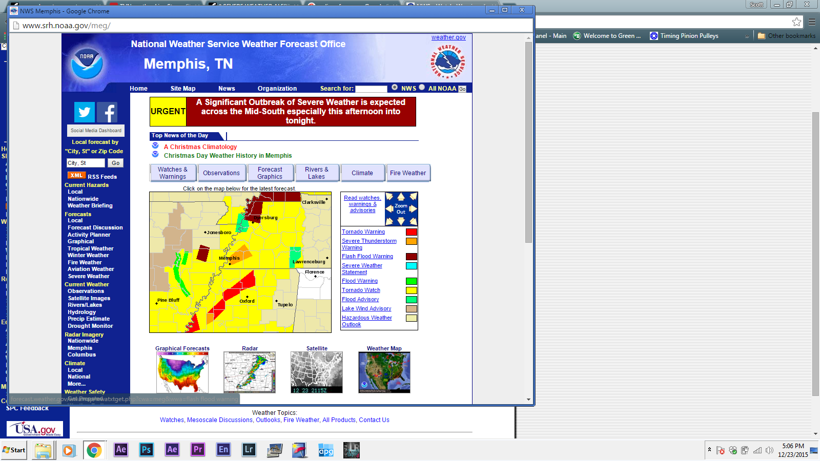
* SEVERE WEATHER ALERT * Tornado Outbreak; Severe Storms Likely - South & Ohio Valley
page: 2share:
I hope these pass most everyone on by. This is maybe one of the worst Christmas presents I could think of.
And I definitely hope these pass my father-in-law by. He's in the hospital up at Vandy recovering from a bone transplant surgery. This would be the last thing they'd need.
And I definitely hope these pass my father-in-law by. He's in the hospital up at Vandy recovering from a bone transplant surgery. This would be the last thing they'd need.
I'm around the Greater Jackson, MS area and it's windy, getting darker and few rumbles of thunder now and then.
Hope it doesn't get worse. Be careful everyone. Looks really bad further north and northern states!
Hope it doesn't get worse. Be careful everyone. Looks really bad further north and northern states!
Coahoma County. New Tornado warning Tutwil area.
edit on 23-12-2015 by hillbilly4rent because: (no reason given)
Bad situation on Inter state 55 near sardis Ms trafic at a stand still spotter relaying to 911 to clear road
edit on 23-12-2015 by hillbilly4rent because: (no reason given)
edit on 23-12-2015 by hillbilly4rent because: (no reason given)
Yeah, it's getting pretty serious right now...
there is an extensive line of Tornado Warnings...
and it's heading right towards population, and the interstate.
there is an extensive line of Tornado Warnings...
and it's heading right towards population, and the interstate.
edit on 23-12-2015 by iunlimited491 because: (no reason given)
a reply to: hillbilly4rent
Dear Lord! I hope those folks know to get out and find a ditch. I hope there are ditches to find. I hope it's not so big that finding a ditch would be a moot point.
Dear Lord! I hope those folks know to get out and find a ditch. I hope there are ditches to find. I hope it's not so big that finding a ditch would be a moot point.
TORNADO WARNING
KYC059-101-149-232145-
/O.NEW.KPAH.TO.W.0040.151223T2118Z-151223T2145Z/
BULLETIN - EAS ACTIVATION REQUESTED
TORNADO WARNING
NATIONAL WEATHER SERVICE PADUCAH KY
318 PM CST WED DEC 23 2015
THE NATIONAL WEATHER SERVICE IN PADUCAH HAS ISSUED A
* TORNADO WARNING FOR...
SOUTHEASTERN HENDERSON COUNTY IN NORTHWESTERN KENTUCKY...
NORTHWESTERN MCLEAN COUNTY IN NORTHWESTERN KENTUCKY...
WESTERN DAVIESS COUNTY IN NORTHWESTERN KENTUCKY...
* UNTIL 345 PM CST
* AT 318 PM CST...A SEVERE THUNDERSTORM CAPABLE OF PRODUCING A
TORNADO WAS LOCATED NEAR SEBREE...OR 11 MILES NORTHWEST OF
CALHOUN...MOVING NORTHEAST AT 70 MPH.
HAZARD...TORNADO AND HALF DOLLAR SIZE HAIL.
SOURCE...RADAR INDICATED ROTATION.
IMPACT...FLYING DEBRIS WILL BE DANGEROUS TO THOSE CAUGHT WITHOUT
SHELTER. MOBILE HOMES WILL BE DAMAGED OR DESTROYED.
DAMAGE TO ROOFS...WINDOWS AND VEHICLES WILL OCCUR. TREE
DAMAGE IS LIKELY.
* THIS DANGEROUS STORM WILL BE NEAR...
ST. JOSEPH AROUND 325 PM CST.
OWENSBORO AND STANLEY AROUND 335 PM CST.
OTHER LOCATIONS IMPACTED BY THIS TORNADIC THUNDERSTORM INCLUDE
HEBBARDSVILLE.
PRECAUTIONARY/PREPAREDNESS ACTIONS...
TAKE COVER NOW! MOVE TO A BASEMENT OR AN INTERIOR ROOM ON THE LOWEST
FLOOR OF A STURDY BUILDING. AVOID WINDOWS. IF YOU ARE OUTDOORS...IN A
MOBILE HOME...OR IN A VEHICLE...MOVE TO THE CLOSEST SUBSTANTIAL
SHELTER AND PROTECT YOURSELF FROM FLYING DEBRIS.
&&
LAT...LON 3757 8737 3759 8740 3759 8746 3760 8748
3761 8749 3765 8750 3765 8756 3790 8731
3785 8723 3784 8719 3781 8714 3778 8713
3779 8709 3778 8708
TIME...MOT...LOC 2118Z 223DEG 63KT 3761 8746
TORNADO...RADAR INDICATED
HAIL...1.25IN
NOAA
SEVERE WEATHER STATEMENT
NATIONAL WEATHER SERVICE LOUISVILLE KY
424 PM EST WED DEC 23 2015
INC077-232145-
/O.CON.KLMK.TO.W.0033.000000T0000Z-151223T2145Z/
JEFFERSON IN-
424 PM EST WED DEC 23 2015
...A TORNADO WARNING REMAINS IN EFFECT UNTIL 445 PM EST FOR
NORTHWESTERN JEFFERSON COUNTY...
AT 424 PM EST...A SEVERE THUNDERSTORM CAPABLE OF PRODUCING A TORNADO
WAS LOCATED 10 MILES WEST OF MADISON...MOVING NORTHEAST AT 45 MPH.
HAZARD...TORNADO.
SOURCE...RADAR INDICATED ROTATION.
IMPACT...FLYING DEBRIS WILL BE DANGEROUS TO THOSE CAUGHT WITHOUT
SHELTER. MOBILE HOMES WILL BE DAMAGED OR DESTROYED. DAMAGE
TO ROOFS...WINDOWS AND VEHICLES WILL OCCUR. TREE DAMAGE IS
LIKELY.
THIS DANGEROUS STORM WILL BE NEAR...
MADISON AROUND 435 PM EST.
OTHER LOCATIONS IMPACTED BY THIS TORNADIC THUNDERSTORM INCLUDE
RINGWALD...SMYRNA...WAKEFIELD...BELLEVIEW...DEPUTY...WIRT...
BRYANTSBURG...NORTH MADISON...MADISON MUNICIPAL AIRPORT AND KENT.
PRECAUTIONARY/PREPAREDNESS ACTIONS...
NOAA
TORNADO WARNING
INC177-OHC037-135-232215-
/O.NEW.KILN.TO.W.0012.151223T2151Z-151223T2215Z/
BULLETIN - EAS ACTIVATION REQUESTED
TORNADO WARNING
NATIONAL WEATHER SERVICE WILMINGTON OH
451 PM EST WED DEC 23 2015
THE NATIONAL WEATHER SERVICE IN WILMINGTON HAS ISSUED A
* TORNADO WARNING FOR...
NORTHEASTERN WAYNE COUNTY IN EAST CENTRAL INDIANA...
NORTHERN PREBLE COUNTY IN WEST CENTRAL OHIO...
SOUTHERN DARKE COUNTY IN WEST CENTRAL OHIO...
* UNTIL 515 PM EST.
* AT 451 PM EST...RADAR INDICATED A SEVERE THUNDERSTORM CAPABLE OF
PRODUCING A TORNADO OVER FOUNTAIN CITY...MOVING EAST AT 50 MPH.
* LOCATIONS IMPACTED INCLUDE...
ARCANUM...NEW MADISON...FOUNTAIN CITY...WAYNE LAKES...ELDORADO...
WEST MANCHESTER...BETHEL...HOLLANSBURG...GORDON...ITHACA...
CASTINE...WHITEWATER...ABBOTTSVILLE AND MIDDLEBORO.
PRECAUTIONARY/PREPAREDNESS ACTIONS...
TAKE COVER NOW. MOVE TO AN INTERIOR ROOM ON THE LOWEST FLOOR OF A
STURDY BUILDING. AVOID WINDOWS. IF IN A MOBILE HOME...A VEHICLE OR
OUTDOORS...MOVE TO THE CLOSEST SUBSTANTIAL SHELTER AND PROTECT
YOURSELF FROM FLYING DEBRIS.
TO REPORT SEVERE WEATHER...GO TO OUR WEBSITE AT WEATHER.GOV/ILN AND
SUBMIT YOUR REPORT VIA SOCIAL MEDIA...WHEN YOU CAN DO SO SAFELY.
&&
LAT...LON 4001 8494 4001 8489 4000 8481 4003 8481
4007 8451 3991 8449 3988 8494 4000 8498
TIME...MOT...LOC 2151Z 258DEG 44KT 3993 8490
TORNADO...RADAR INDICATED
$$
NOAA
Hey, Everyone - I had to step away for a short time.
But this is still an ongoing situation, and looks to continue well in to tonight.
Multiple Tornado Warnings are still in effect at the moment...
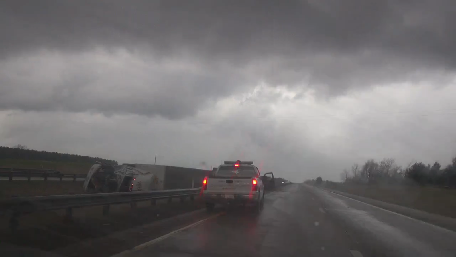
And extensive damage has been reported
_____
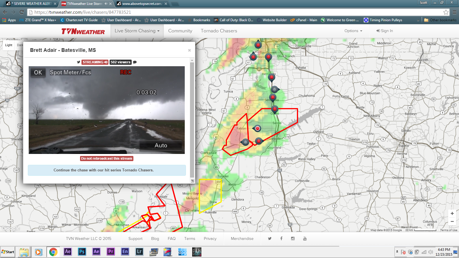
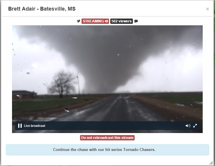
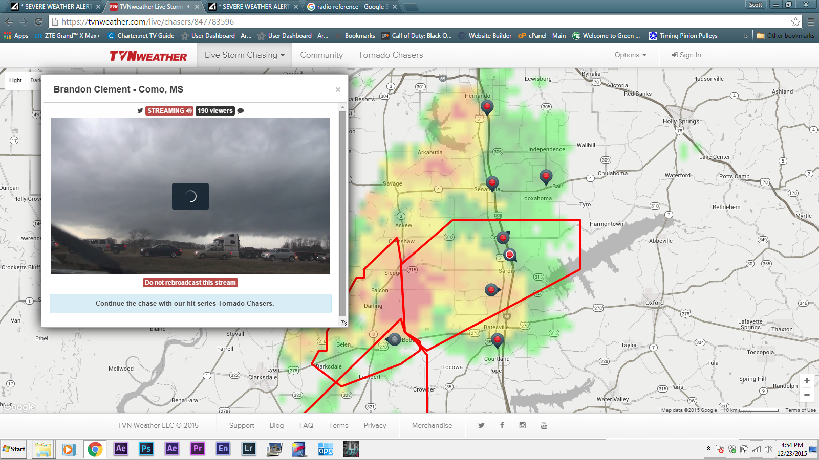
Below is one of the many videos of the Clarksdale, MS Tornado
But this is still an ongoing situation, and looks to continue well in to tonight.
Multiple Tornado Warnings are still in effect at the moment...
And extensive damage has been reported
_____
Below is one of the many videos of the Clarksdale, MS Tornado
a reply to: iunlimited491
Thank you for the thread!
It is nice to have "real" people updating rather than JUST the weather channel, etc.
The link to the live storm chasers was great!
Unfortunately, I think, I heard a small child was killed tonight.
I think my area is "in the clear" so to speak...all of my loved ones safe...I wish that for everyone too.
South of Nashville looks like there may be something coming.
Our "watch" lasts until 11 pm...no worries, I won't be asleep anyway...
new topics
-
President BIDEN's FBI Raided Donald Trump's Florida Home for OBAMA-NORTH KOREA Documents.
Political Conspiracies: 1 hours ago -
Maestro Benedetto
Literature: 3 hours ago -
Is AI Better Than the Hollywood Elite?
Movies: 3 hours ago -
Las Vegas UFO Spotting Teen Traumatized by Demon Creature in Backyard
Aliens and UFOs: 6 hours ago -
2024 Pigeon Forge Rod Run - On the Strip (Video made for you)
Automotive Discussion: 7 hours ago -
Gaza Terrorists Attack US Humanitarian Pier During Construction
Middle East Issues: 8 hours ago -
The functionality of boldening and italics is clunky and no post char limit warning?
ATS Freshman's Forum: 9 hours ago -
Meadows, Giuliani Among 11 Indicted in Arizona in Latest 2020 Election Subversion Case
Mainstream News: 9 hours ago -
Massachusetts Drag Queen Leads Young Kids in Free Palestine Chant
Social Issues and Civil Unrest: 10 hours ago -
Weinstein's conviction overturned
Mainstream News: 11 hours ago
top topics
-
President BIDEN's FBI Raided Donald Trump's Florida Home for OBAMA-NORTH KOREA Documents.
Political Conspiracies: 1 hours ago, 13 flags -
Krystalnacht on today's most elite Universities?
Social Issues and Civil Unrest: 13 hours ago, 9 flags -
University of Texas Instantly Shuts Down Anti Israel Protests
Education and Media: 15 hours ago, 8 flags -
Supreme Court Oral Arguments 4.25.2024 - Are PRESIDENTS IMMUNE From Later Being Prosecuted.
Above Politics: 12 hours ago, 8 flags -
Gaza Terrorists Attack US Humanitarian Pier During Construction
Middle East Issues: 8 hours ago, 7 flags -
Weinstein's conviction overturned
Mainstream News: 11 hours ago, 7 flags -
Massachusetts Drag Queen Leads Young Kids in Free Palestine Chant
Social Issues and Civil Unrest: 10 hours ago, 7 flags -
Meadows, Giuliani Among 11 Indicted in Arizona in Latest 2020 Election Subversion Case
Mainstream News: 9 hours ago, 5 flags -
Las Vegas UFO Spotting Teen Traumatized by Demon Creature in Backyard
Aliens and UFOs: 6 hours ago, 4 flags -
2024 Pigeon Forge Rod Run - On the Strip (Video made for you)
Automotive Discussion: 7 hours ago, 3 flags
active topics
-
President BIDEN's FBI Raided Donald Trump's Florida Home for OBAMA-NORTH KOREA Documents.
Political Conspiracies • 3 • : xuenchen -
Is AI Better Than the Hollywood Elite?
Movies • 10 • : 5thHead -
Sol Et Luna - TIME2024
Short Stories • 10 • : BrotherKinsMan -
University of Texas Instantly Shuts Down Anti Israel Protests
Education and Media • 263 • : cherokeetroy -
Massachusetts Drag Queen Leads Young Kids in Free Palestine Chant
Social Issues and Civil Unrest • 13 • : ToneD -
Gaza Terrorists Attack US Humanitarian Pier During Construction
Middle East Issues • 26 • : nugget1 -
British TV Presenter Refuses To Use Guest's Preferred Pronouns
Education and Media • 168 • : Annee -
Manly P. Hall says Freemasonry is a religion?
Secret Societies • 22 • : Therealbeverage -
One Flame Throwing Robot Dog for Christmas Please!
Weaponry • 11 • : Therealbeverage -
HORRIBLE !! Russian Soldier Drinking Own Urine To Survive In Battle
World War Three • 48 • : Therealbeverage