It looks like you're using an Ad Blocker.
Please white-list or disable AboveTopSecret.com in your ad-blocking tool.
Thank you.
Some features of ATS will be disabled while you continue to use an ad-blocker.

* SEVERE WEATHER ALERT * Tornado Outbreak; Severe Storms Likely - South & Ohio Valley
page: 1share:
Tornado Outbreak; Severe Storms Likely - South & Ohio Valley
Happy Holidays, ATS!
This post is concerning the potential for an extremely dangerous weather scenario that is currently developing in parts of the Ohio Valley and Southern United States.
23 December 2015 - Day1 Convective Outook
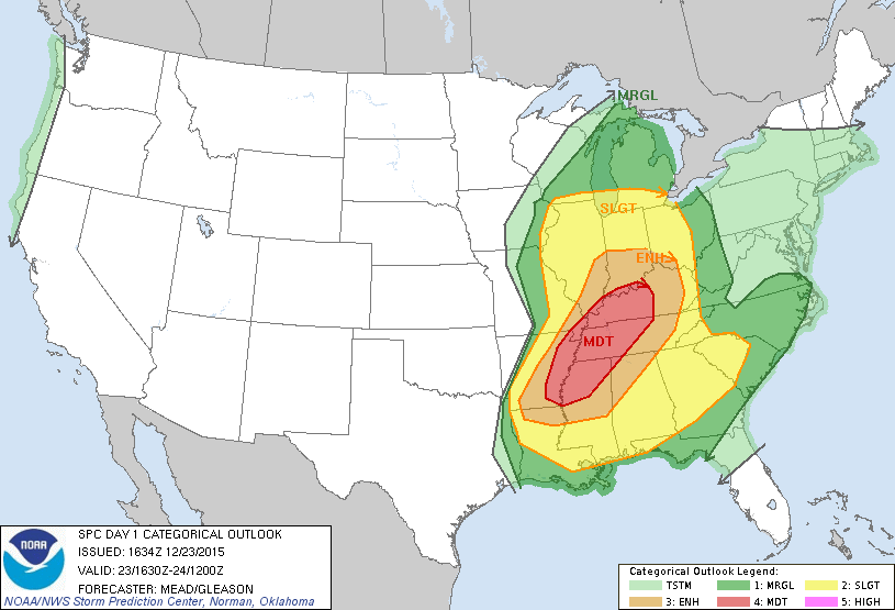 www.spc.noaa.gov...
_____
This is a developing situation, so as always - be sure to stay up to date on any watches and/or warnings if you live in these areas.
This is a rather precarious event, being so close to Christmas
- so all the best to those at the mercy of Nature.
Tornado Warnings and Watches are already in effect.
Updates and more links will follow. Be safe.
_____
TVN - Live Storm Chasing
Happy Holidays, ATS!
This post is concerning the potential for an extremely dangerous weather scenario that is currently developing in parts of the Ohio Valley and Southern United States.
23 December 2015 - Day1 Convective Outook
www.spc.noaa.gov...
...SUMMARY...
AN OUTBREAK OF SEVERE THUNDERSTORMS AND TORNADOES IS FORECAST TODAY INTO TONIGHT FROM THE OHIO VALLEY INTO THE TENNESSEE AND LOWER MISSISSIPPI VALLEYS.
THE GREATEST RISK FOR A FEW INTENSE...LONG-TRACKED TORNADOES WILL EXIST OVER WESTERN TENNESSEE INTO NORTHERN MISSISSIPPI AND EASTERN ARKANSAS THIS AFTERNOON INTO TONIGHT.
_____
www.weather.com...
Severe thunderstorms have already caused structural damage and destroyed homes this morning in Arkansas, and the threat will only increase and become more widespread in parts of the South and Ohio Valley through this afternoon as a likely tornado outbreak gets underway.
The Tornado Conditions Index, better known as TOR:CON, has been raised to as high as 8 out of 10 for parts of west Tennessee, northern Mississippi and northern Alabama on Wednesday, meaning there's a 80 percent chance of a tornado within 50 miles of any location in the indicated area. Tornadoes and damaging winds will also be possible in a much larger area from the Gulf Coast to the Ohio Valley. This includes TOR:CON values as high as 7 in eastern Arkansas, 6 in west Kentucky and south Mississippi, and 5 in southeast Missouri and northeast Louisiana.
This is a developing situation, so as always - be sure to stay up to date on any watches and/or warnings if you live in these areas.
This is a rather precarious event, being so close to Christmas
- so all the best to those at the mercy of Nature.
Tornado Warnings and Watches are already in effect.
Updates and more links will follow. Be safe.
_____
TVN - Live Storm Chasing
edit on 23-12-2015 by iunlimited491 because: (no reason given)
a reply to: iunlimited491
Thank you for the update on Arkansas...
Reason: we in middle TN seem to often get what Arkansas get!
Thank you for the update on Arkansas...
Reason: we in middle TN seem to often get what Arkansas get!
edit on 23-12-2015 by TNMockingbird because: see above
I`m just SW of Little Rock. The dew point just started dropping, so I think this area is just about done with the threat.
We had some minor flooding, and lots of hail, but wind didn`t get over 35mph sustained here. Gusts not much higher than that.
There are power outages in many areas....www.etrviewoutage.com...
Just a report from this part of AR.
Stay safe!!!!
We had some minor flooding, and lots of hail, but wind didn`t get over 35mph sustained here. Gusts not much higher than that.
There are power outages in many areas....www.etrviewoutage.com...
Just a report from this part of AR.
Stay safe!!!!
edit on 23-12-2015 by dragonlover12 because: (no reason given)
Have seen several tornado warning scroll across my twitter feed. The "target" keeps shifting east. Knoxville is now in the "damage likely" zone.
West of Knoxville is the worst in Tennessee with a torcon of 8.
Hate to see damaging weather anytime, but especially like this, just before Christmas. Could be a lot of disappointed kids in a couple days.
Hate to see damaging weather anytime, but especially like this, just before Christmas. Could be a lot of disappointed kids in a couple days.
Christmas tornadoes? I grew up in the Midwest, this seems extremely late.
Please be safe everyone! Best of luck to you all.
Please be safe everyone! Best of luck to you all.
It is 66 degrees here west of Arkansas Can we just blame this on 'global warming'? /sarc
stay safe over there y'all
stay safe over there y'all
The NWS has issued a PDS Particularly Dangerous Situation on Tornado Watch 559:
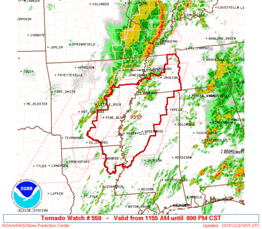
www.spc.noaa.gov...
URGENT - IMMEDIATE BROADCAST REQUESTED
TORNADO WATCH NUMBER 559
* TORNADO WATCH FOR PORTIONS OF
SOUTHEAST ARKANSAS
FAR NORTHEAST LOUISIANA
NORTHERN AND WESTERN MISSISSIPPI
WESTERN TENNESSEE
* EFFECTIVE THIS WEDNESDAY MORNING AND EVENING FROM 1155 AM UNTIL 800 PM CST.
...THIS IS A PARTICULARLY DANGEROUS SITUATION...
* PRIMARY THREATS INCLUDE...
SEVERAL TORNADOES AND A FEW INTENSE TORNADOES LIKELY...
SCATTERED DAMAGING WINDS LIKELY WITH ISOLATED SIGNIFICANT GUSTS TO 75 MPH POSSIBLE...
ISOLATED LARGE HAIL EVENTS TO 1.5 INCHES IN DIAMETER POSSIBLE...
edit on 23-12-2015 by iunlimited491 because: (no reason given)
a reply to: iunlimited491
Wind is picking up here in the middle of Hellinois. Supposed to get ugly around two. Possible tornadoes.
Stay safe all.
Wind is picking up here in the middle of Hellinois. Supposed to get ugly around two. Possible tornadoes.
Stay safe all.
Thanks Everyone -
I'm posting the TVN Live Storm Chasing Link
^which I have also edited into the OP.
I'm posting the TVN Live Storm Chasing Link
^which I have also edited into the OP.
The "watch" area is quite large IMO.
NWS
I just used Memphis as reference.
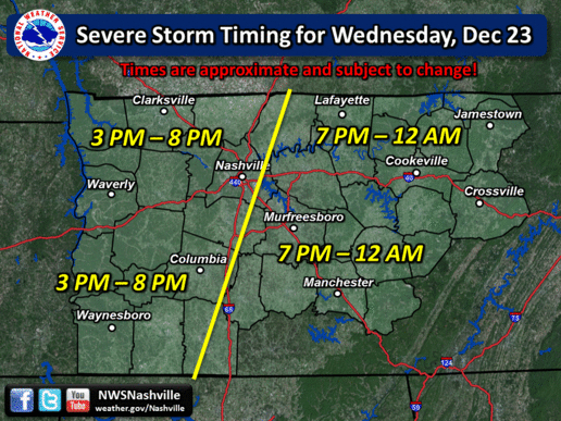
The predicted timing for my neighbors. Hopefully everyone can get home and settled in before the BIG stuff comes. If at all!
I've been keeping an eye on this chart as well since early morning...
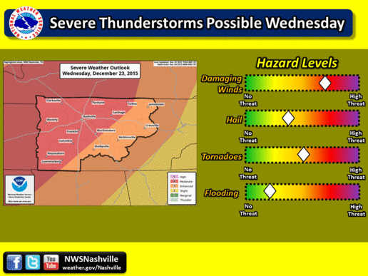
The damaging wind and tornado threat has increased.
The damaging wind was about 1/2 way.
The tornado was barely in the yellow.
Earlier...be vigilant!
NWS
I just used Memphis as reference.
The predicted timing for my neighbors. Hopefully everyone can get home and settled in before the BIG stuff comes. If at all!
edit on 23-12-2015
by TNMockingbird because: more specific
I've been keeping an eye on this chart as well since early morning...
The damaging wind and tornado threat has increased.
The damaging wind was about 1/2 way.
The tornado was barely in the yellow.
Earlier...be vigilant!
edit on 23-12-2015 by TNMockingbird because: more specific
Regarding the PDS that was issued moments ago and posted above: Link
www.weather.com...
A "particularly dangerous situation" (PDS) tornado watch has been issued by NOAA's Storm Prediction Center (SPC) for parts eastern Arkansas, northwest Mississippi, northeast Louisiana and western Tennessee until 8 p.m. CST.
This type of tornado watch is issued in rare situations when long-lived intense tornadoes are likely, according to the SPC.
National Radar Loop - 23 December 2015
 www.intellicast.com...
_____
Live Updates and Storm Reports:
twitter.com/FEMAlive/lists/happening-now
edit on 23-12-2015 by iunlimited491
because: (no reason given)
_____
Live Updates and Storm Reports:
twitter.com/FEMAlive/lists/happening-now
edit on 23-12-2015 by iunlimited491
because: (no reason given)
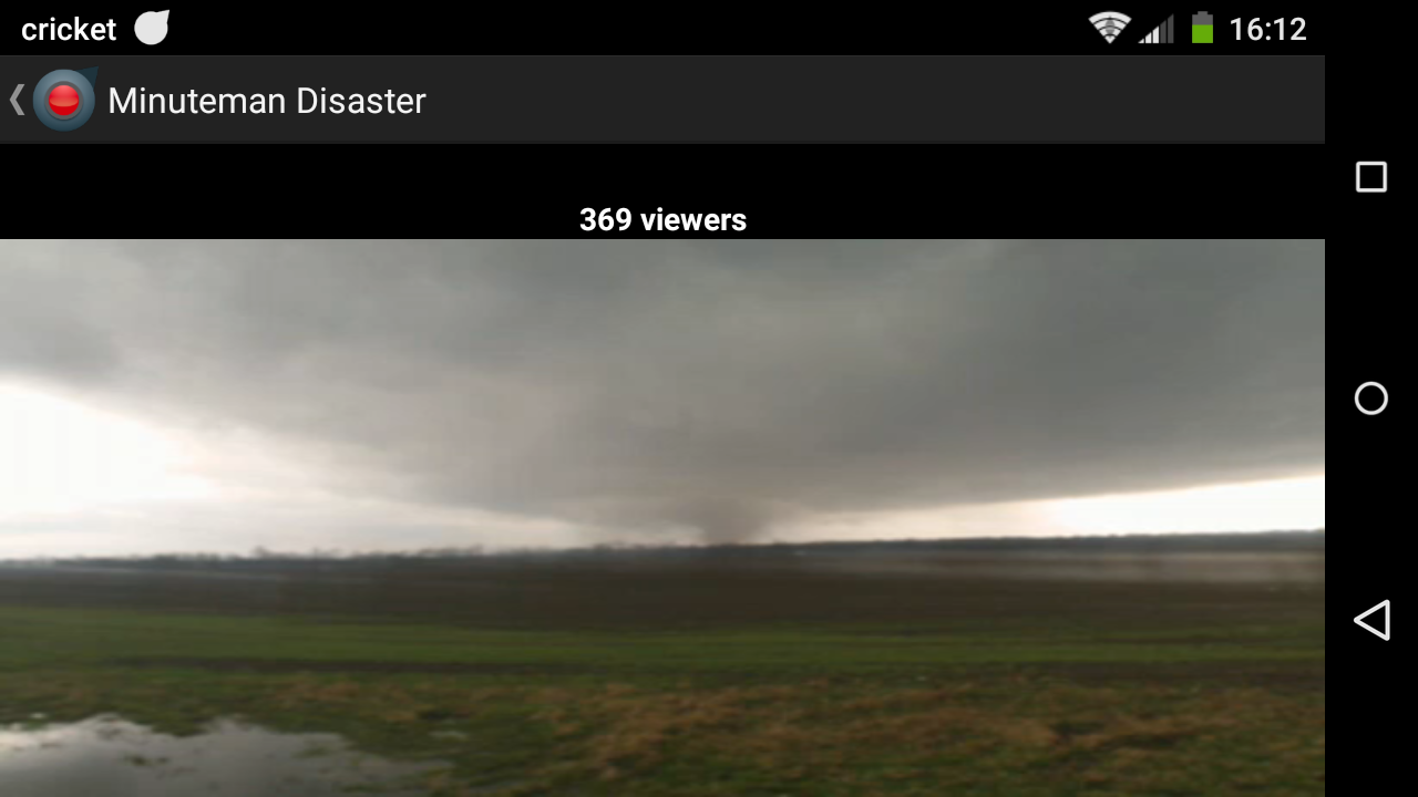
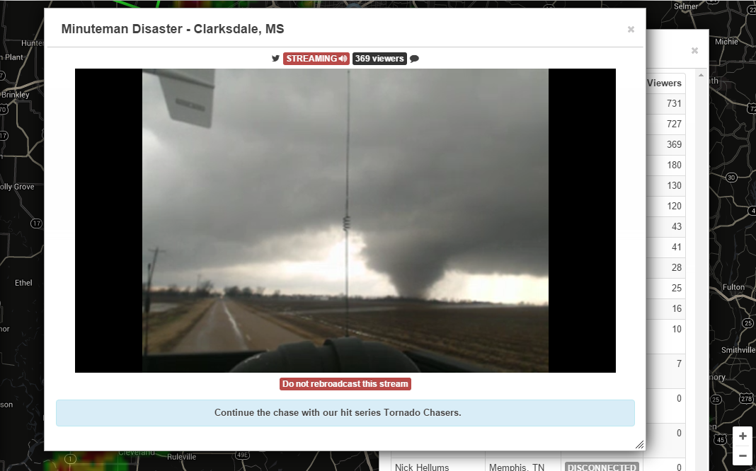
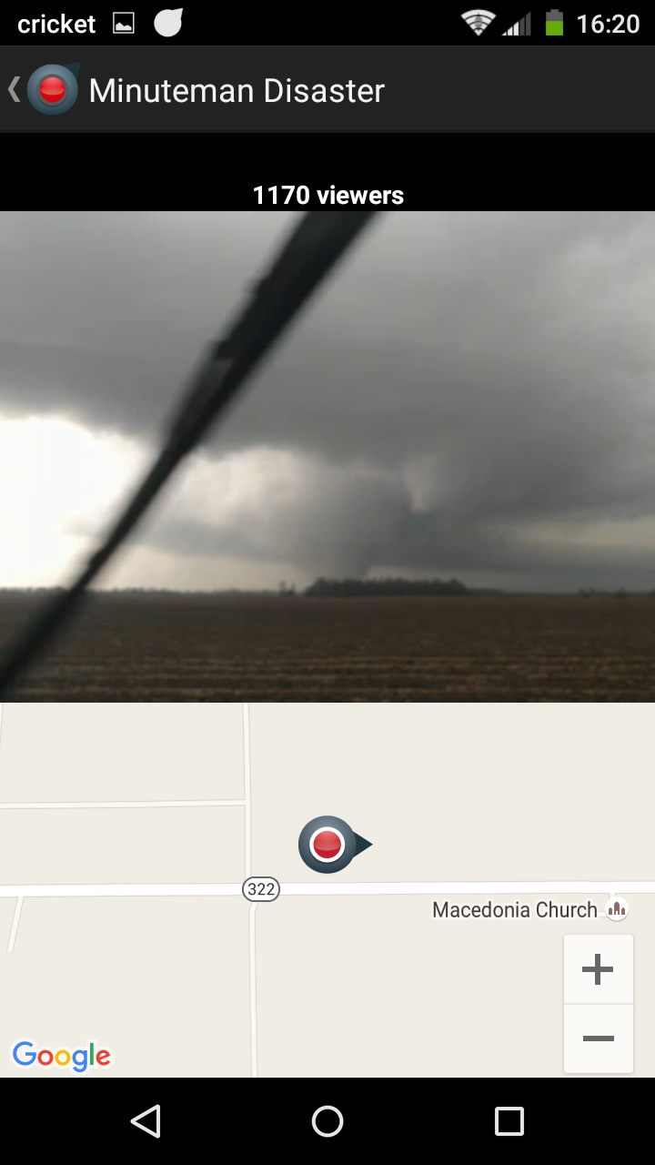
TORNADO CURRENTLY ON THE GROUND CLARKSDALE, MS
CAN BE VIEWED LIVE HERE: tvnweather.com...
CAN BE VIEWED LIVE HERE: tvnweather.com...
. A Tornado Warning remains in effect until 345 PM CST for
southeastern Coahoma County...
at 309 PM CST... a confirmed large and extremely dangerous tornado was
located near Clarksdale... moving northeast at 55 mph.
This is a particularly dangerous situation.
Hazard... damaging tornado.
Source... storm chasers confirmed tornado.
Impact... you are in a life threatening situation. Flying debris may
be deadly to those caught without shelter. Mobile homes
will be destroyed. Considerable damage to
homes... businesses and vehicles is likely and complete
destruction is possible.
edit on 23-12-2015 by iunlimited491 because: (no reason given)
a reply to: hillbilly4rent
Nice! Thanks for posting...
I just grabbed one myself...
_____
MULTIPLE Tornado Warnings going on right now.
Nice! Thanks for posting...
I just grabbed one myself...
_____
MULTIPLE Tornado Warnings going on right now.
edit on 23-12-2015 by iunlimited491 because: (no reason given)
Those cells rolled through here last night. I don't get waken up by thunder often, but it woke me up last night. NW LA.
new topics
-
What is the white pill?
Philosophy and Metaphysics: 24 minutes ago -
Mike Pinder The Moody Blues R.I.P.
Music: 1 hours ago -
Putin, Russia and the Great Architects of the Universe
ATS Skunk Works: 4 hours ago -
A Warning to America: 25 Ways the US is Being Destroyed
New World Order: 8 hours ago
top topics
-
President BIDEN's FBI Raided Donald Trump's Florida Home for OBAMA-NORTH KOREA Documents.
Political Conspiracies: 14 hours ago, 32 flags -
A Warning to America: 25 Ways the US is Being Destroyed
New World Order: 8 hours ago, 14 flags -
Is AI Better Than the Hollywood Elite?
Movies: 16 hours ago, 4 flags -
Mike Pinder The Moody Blues R.I.P.
Music: 1 hours ago, 2 flags -
Maestro Benedetto
Literature: 15 hours ago, 1 flags -
Putin, Russia and the Great Architects of the Universe
ATS Skunk Works: 4 hours ago, 1 flags -
What is the white pill?
Philosophy and Metaphysics: 24 minutes ago, 1 flags
active topics
-
Meadows, Giuliani Among 11 Indicted in Arizona in Latest 2020 Election Subversion Case
Mainstream News • 18 • : IndieA -
President BIDEN's FBI Raided Donald Trump's Florida Home for OBAMA-NORTH KOREA Documents.
Political Conspiracies • 26 • : dothedew -
A Warning to America: 25 Ways the US is Being Destroyed
New World Order • 20 • : jidnum2 -
Gaza Terrorists Attack US Humanitarian Pier During Construction
Middle East Issues • 62 • : CarlLaFong -
New whistleblower Jason Sands speaks on Twitter Spaces last night.
Aliens and UFOs • 69 • : Ophiuchus1 -
Putin, Russia and the Great Architects of the Universe
ATS Skunk Works • 16 • : CristianVictoria -
Alternate Electors vs Fake Electors - What is the Difference.
2024 Elections • 123 • : frogs453 -
Massachusetts Drag Queen Leads Young Kids in Free Palestine Chant
Social Issues and Civil Unrest • 17 • : ToneD -
Hate makes for strange bedfellows
US Political Madness • 51 • : network dude -
The Acronym Game .. Pt.3
General Chit Chat • 7755 • : F2d5thCavv2