It looks like you're using an Ad Blocker.
Please white-list or disable AboveTopSecret.com in your ad-blocking tool.
Thank you.
Some features of ATS will be disabled while you continue to use an ad-blocker.

Flat Earth Believers, I would like to hear your ideas.
page: 39share:
a reply to: eriktheawful
all valid points - but as most of us dont have access to warships and radar sets - an " easier to digest " analogy =
watch a commercial aircraft in flight above you [ use flight radar 24 or a rival service to id it and verify its course and altutude ]
and ask a flat earther - whats its altitude and again ask them same question 10 min later
sit back and watch an exquitite display of mental gymnastics

a reply to: eriktheawful
About the two technologies you named, one tracking the IFF plane at 20k altitude and their equipment showing the same altitude, does that not mean your beam is tracking the plane and not the surface, serious question since i never used such technology, or are you saying that yoru beam is pointing horizontal yet tracking the distant plane at the proper altitude due to curvature? No disrespect at all purely a question.
For the cruise missile is the target distance 60 miles or its observable path? I mean, it would obviously dip due to reaching its target or running out of velocity i assume? Honest question i find that stuff amazing.
edit on 16-1-2017 by NNN87 because: (no reason given)
originally posted by: ignorant_ape
a reply to: eriktheawful
all valid points - but as most of us dont have access to warships and radar sets - an " easier to digest " analogy =
watch a commercial aircraft in flight above you [ use flight radar 24 or a rival service to id it and verify its course and altutude ]
and ask a flat earther - whats its altitude and again ask them same question 10 min later
sit back and watch an exquitite display of mental gymnastics
The flights below the equator are in question, which cannot be tracked, but since i recently found out one can now bring an untethered GPS device i believe correct me if i am wrong, well, now we can make some real observations, below equator flights of course.
a reply to: MuonToGluon
Well now you just sound like a religious person, tested the curvature'', how?
Compulsive liar is a personal and wrong assumption, based on words not a person you met, and a very few words as a matter of fact, so no, you have no manners.
You judge solely on title, what curvature? I have never seen a bent horizon, it's not called curhizon for a reason, what you are seeing is the limit of eyesight, that is the very definition of horizon.
edit on 16-1-2017 by NNN87 because: (no reason given)
a reply to: NNN87
There are several ways for a radar system to track the altitude of an object in the air.
One of them is the angle at which the dish is pointed (most common on tracking radars, picture a dish like antenna used for satellite TV).
The angle of the dish is measured against the reference plane of horizontal (IE 0 deg azimuth). This is normally done with a synchro device (picture a small DC motor).
A computer uses a ADC converter to convert the analog signal of the synchro to digital information that your synchronizer (computer) will understand.
Using simple trigonometry, because you also know the distance of the object, you can complete the right triangle (IE finding the side of that triangle opposite of the angle of the dish).
Now, an air craft flying at 10,000 feet only 10 miles away, the angle of the dish will be much greater than then if the aircraft were flying at that same altitude but 100 miles away (IE appears much lower in the sky).
RF energy doesn't care about "perspective" (a word I keep being thrown around here alot), it cares about how long it took for the energy to get there and back (distance), the angle at which the antenna his pointed (height) and the direction it is pointed in (relative direction to where the radar is mounted).
Now, let's have that aircraft at only 100 feet at 10 miles.......then keep flying it at 100 feet but go to 100 miles out: do that and the radar dish will be pointing in a line down into the ocean.
Because the surface of the world is curved.
That's also why people trying to throw out that "perspective" word are wrong too. If what they say held true, then what would happen as ships sail away from a large city, it would appear to just get smaller and smaller. But that's all it would do.
Instead: the buildings of the city also appear to sink.
Perspective doesn't give you the sink part. Just the shrink part.
Radar again: have land mass that the surface search radar paints on it's PPI scope, and have some hills or mountains not too far inland. The radar will paint that coast line just fine.
Now move away from it. Guess what happens? It still appears there, but when you get far enough, the coast seems to disappear from the radar screen.....yet those hills and mountains will still be there a while longer, until they too seem too slowly disappear.
Too far for the radar? Ha: then why can I still track the VERY SMALLER AIRCRAFT flying over that land at the same distance?
It's because the radar beam is going straight out (it doesn't follow the curve of the Earth) and the aircraft are flying high enough to be painted by the beam.....but the land has gone below the horizon.....due to the curvature of the Earth.
You know we've mapped the Moon with Radar? RF energy travels at the same speed as light....and your radar knows how long it took for the radar pulse to leave the dish get to the Moon, and how long it took to get back. It's pretty fast, about 3 seconds round trip.....giving the Moon an average distance of 250,000 miles, and once again, the wonderful thing called trigonometry allows us to figure out the diameter of the moon as we're mapping it, with the movement of the antenna as each pulse leaves and comes back. It really is 1,080 miles wide.
That or trigonometry is wrong (and I doubt that seriously).
So that same radar can see the top of that sky scraper....that keeps getting lower....and lower......and lower until it's sunken below the horizon. Because the surface of the Earth is curved.
If the Earth really was flat: that radar would continue to paint the building even 200 miles away.
Don't have to take my word for it either. Talk to anyone who's ever worked with radar systems, or on them (that would be me, doing both).
originally posted by: NNN87
a reply to: MuonToGluon
Well now you just sound like a religious person, tested the curvature'', how?
Compulsive liar is a personal and wrong assumption, based on words not a person you met, and a very few words as a matter of fact, so no, you have no manners.
You judge solely on title, what curvature? I have never seen a bent horizon, it's not called curhizon for a reason, what you are seeing is the limit of eyesight, that is the very definition of horizon.
I am a person without religion and a person who is not an atheist either, I have grand respect for all religion and I will defend ones religion to the core and that person if I need to, I am that respectful and defensive I even lease a building out to an Islamic Gym and Prayer hall and I live behind it on the same property.
If you decided to read my statement I said I choose for who I have respect or manners for, I have chosen not to display any manners towards you and be blunt instead.
My proof is 100+ years of science and witnessing it myself; you are the one who is claiming everyone on this planet is wrong and you are right, you are not.
If you live in Australia I will invite you to come with me for an High altitude balloon flight, I am good friends with a business man who has a very extreme aviation hobby, and all I ask in return is $20-30 of fuel for the car trip.
I am being serious.
a reply to: NNN87
flights in the souther hemisphere are not " in question "
thats just your delusion
as for tracking AIS tracks vessels at any distance across the southern oceans
that neatly contradicts the no tracking claim
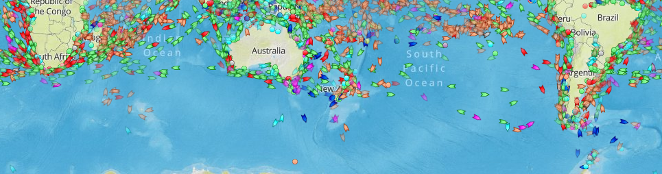
there - ships departuures and arrivals at port are consistent with thier design speed and allowances for weather
flights in the souther hemisphere are not " in question "
thats just your delusion
as for tracking AIS tracks vessels at any distance across the southern oceans
that neatly contradicts the no tracking claim
there - ships departuures and arrivals at port are consistent with thier design speed and allowances for weather
a reply to: NNN87
All flights, everywhere disappear off radar. Radar can only see about 250 miles, unless it's an over the horizon system. Once you go beyond the horizon, the radar signal can't curve to follow a target.
If you're talking about websites that track aircraft, until they find a way to place an ADS-B receiver in the middle of the ocean, no website will be able to track any flight for its entire duration, and the portions over the ocean will always be estimated positions, no matter what hemisphere they're in. I showed you several flights from Australia, and the South Pacific heading to the US that were tracked and didn't "disappear" during the flight.
edit on 1/17/2017 by Zaphod58 because: (no reason given)
originally posted by: ignorant_ape
a reply to: NNN87
flights in the souther hemisphere are not " in question "
thats just your delusion
as for tracking AIS tracks vessels at any distance across the southern oceans
that neatly contradicts the no tracking claim
there - ships departuures and arrivals at port are consistent with thier design speed and allowances for weather
I don't know what that picture is based on, there are radar sites, which track planes in the northern hemisphere, so we know their path.
In the southern hemisphere flights that supposedly travel across the paths that are drawn on a globular projection disappear, there is flightradar24 and many others, like i said i don't know what your picture is based on.
originally posted by: Zaphod58
a reply to: NNN87
All flights, everywhere disappear off radar. Radar can only see about 250 miles, unless it's an over the horizon system. Once you go beyond the horizon, the radar signal can't curve to follow a target.
If you're talking about websites that track aircraft, until they find a way to place an ADS-B receiver in the middle of the ocean, no website will be able to track any flight for its entire duration, and the portions over the ocean will always be estimated positions, no matter what hemisphere they're in. I showed you several flights from Australia, and the South Pacific heading to the US that were tracked and didn't "disappear" during the flight.
It's not the website watching the traffic, its the actual radar system which the website uses, and if there are satellites, what blind spots?
Also the definition for horizon, is the limit of eyesight, where the sky and land APPEAR to meet. Literal definition.
edit on 20-1-2017 by
NNN87 because: (no reason given)
a reply to: NNN87
Aircraft are not tracked across oceans. They have radio check points where they provide flight data to ground stations. Websites display their projected routes.
flightaware.com...
It's not the website watching the traffic, its the actual radar system which the website uses
Aircraft are not tracked across oceans. They have radio check points where they provide flight data to ground stations. Websites display their projected routes.
Aircraft are not routinely tracked by satellites.
and if there are satellites, what blind spots?
No idea what you are talking about.
In the southern hemisphere flights that supposedly travel across the paths that are drawn on a globular projection disappear,
flightaware.com...
edit on 1/20/2017 by Phage because: (no reason given)
a reply to: MuonToGluon
The day i get there i send you a message, that's awesome.
Have you read on optic laws and atmospheric perspective and such?
No, the people hundreds of years ago were not wrong, but eventually funded by the church, think about that.
Education, laws, science, astronomy and the list goes on, even holidays, are based on orthodox, Catholic and Christian funding, if you bother to look.
So yeah, most of you are religious, mathematical equations explaining a fake reality based on obviously natural flaws of eyesight and the limits that are very easily measured, yet not taken into account is the only flaw, and not even a flaw but an intentional strategic move in history on the churches behalf.
originally posted by: Phage
a reply to: NNN87
It's not the website watching the traffic, its the actual radar system which the website uses
Aircraft are not tracked across oceans. They have radio check points where they provide flight data to ground stations. Websites display their projected routes.
Aircraft are not routinely tracked by satellites.
and if there are satellites, what blind spots?
If aircraft's are not tracked over oceans, then explain northern hemisphere flights which can be tracked, if the plane is not routinely tracked by satellites and are based on ground control then why do the southern hemisphere flights disappear on radar?
a reply to: NNN87
They are not tracked. Like I said.
If aircraft's are not tracked over oceans, then explain northern hemisphere flights which can be tracked
The same reason northern hemisphere flights do.
why do the southern hemisphere flights disappear on radar?
a reply to: NNN87
appologies - i should have cited the source , here :
source
and here is an overview of AIS technologies :
wikki article
so - this demonstrates that marine traffic is trackable world wide - with no gaps in coverage or blind spots - and that thier movements and transit times are congruent with the spheroid model
as ATS member " zaphod58 " is active in this thread - i shall limit my future responses on this issue to maritime systems
edit on 20-1-2017
by ignorant_ape because: BB code formats
a reply to: NNN87
There is NO radar used, anywhere that tracks aircraft the entire duration of their flight. I don't know where you came up with that one, but it couldn't be farther from the truth. Unless it's a huge radar system, it can't see beyond about 250 miles. Beyond that, the beam can't curve and see, unless you elevate the antenna, and put it higher, like on a hill.
There are no satellites capable of using a radar system to track aircraft. There are systems capable of tracking the transponder of an aircraft, which transmits its location based off the aircraft navigation systems. That is what is being tracked on long haul flights. That is also what the flight tracking sites are using. They would have to pay millions to buy a radar system, and would require them all over the world to track flights the way they do. There is no radar system.
en.m.wikipedia.org...
There is NO radar used, anywhere that tracks aircraft the entire duration of their flight. I don't know where you came up with that one, but it couldn't be farther from the truth. Unless it's a huge radar system, it can't see beyond about 250 miles. Beyond that, the beam can't curve and see, unless you elevate the antenna, and put it higher, like on a hill.
There are no satellites capable of using a radar system to track aircraft. There are systems capable of tracking the transponder of an aircraft, which transmits its location based off the aircraft navigation systems. That is what is being tracked on long haul flights. That is also what the flight tracking sites are using. They would have to pay millions to buy a radar system, and would require them all over the world to track flights the way they do. There is no radar system.
The radar horizon is a critical area of performance for aircraft detection systems that is defined by the distance at which the radar beam rises enough above the Earth's surface to make detection of a target at low level impossible. It is associated with the low elevation region of performance and its geometry depends on terrain, radar height, and signal processing. This is associated with the notions of radar shadow, the clutter zone, and the clear zone.
en.m.wikipedia.org...
edit on 1/20/2017 by Zaphod58 because: (no reason given)
edit on 1/20/2017 by Zaphod58 because: (no reason given)
a reply to: NNN87
They're tracked by transponder. The aircraft sends a unique identifier, along with altitude, airspeed, and other information. You're not looking at a radar picture. It's normally sent by a dedicated radio signal, but newer types also use satellites, if the aircraft is equipped.
They're tracked by transponder. The aircraft sends a unique identifier, along with altitude, airspeed, and other information. You're not looking at a radar picture. It's normally sent by a dedicated radio signal, but newer types also use satellites, if the aircraft is equipped.
new topics
-
Maestro Benedetto
Literature: 50 minutes ago -
Is AI Better Than the Hollywood Elite?
Movies: 59 minutes ago -
Las Vegas UFO Spotting Teen Traumatized by Demon Creature in Backyard
Aliens and UFOs: 4 hours ago -
2024 Pigeon Forge Rod Run - On the Strip (Video made for you)
Automotive Discussion: 5 hours ago -
Gaza Terrorists Attack US Humanitarian Pier During Construction
Middle East Issues: 5 hours ago -
The functionality of boldening and italics is clunky and no post char limit warning?
ATS Freshman's Forum: 6 hours ago -
Meadows, Giuliani Among 11 Indicted in Arizona in Latest 2020 Election Subversion Case
Mainstream News: 7 hours ago -
Massachusetts Drag Queen Leads Young Kids in Free Palestine Chant
Social Issues and Civil Unrest: 7 hours ago -
Weinstein's conviction overturned
Mainstream News: 8 hours ago -
Supreme Court Oral Arguments 4.25.2024 - Are PRESIDENTS IMMUNE From Later Being Prosecuted.
Above Politics: 10 hours ago
top topics
-
Krystalnacht on today's most elite Universities?
Social Issues and Civil Unrest: 10 hours ago, 9 flags -
Supreme Court Oral Arguments 4.25.2024 - Are PRESIDENTS IMMUNE From Later Being Prosecuted.
Above Politics: 10 hours ago, 8 flags -
University of Texas Instantly Shuts Down Anti Israel Protests
Education and Media: 13 hours ago, 7 flags -
Weinstein's conviction overturned
Mainstream News: 8 hours ago, 7 flags -
Gaza Terrorists Attack US Humanitarian Pier During Construction
Middle East Issues: 5 hours ago, 7 flags -
Massachusetts Drag Queen Leads Young Kids in Free Palestine Chant
Social Issues and Civil Unrest: 7 hours ago, 6 flags -
Meadows, Giuliani Among 11 Indicted in Arizona in Latest 2020 Election Subversion Case
Mainstream News: 7 hours ago, 5 flags -
Las Vegas UFO Spotting Teen Traumatized by Demon Creature in Backyard
Aliens and UFOs: 4 hours ago, 4 flags -
2024 Pigeon Forge Rod Run - On the Strip (Video made for you)
Automotive Discussion: 5 hours ago, 2 flags -
Any one suspicious of fever promotions events, major investor Goldman Sachs card only.
The Gray Area: 15 hours ago, 2 flags
active topics
-
VP's Secret Service agent brawls with other agents at Andrews
Mainstream News • 60 • : CarlLaFong -
University of Texas Instantly Shuts Down Anti Israel Protests
Education and Media • 228 • : cherokeetroy -
SETI chief says US has no evidence for alien technology. 'And we never have'
Aliens and UFOs • 72 • : yuppa -
My Poor Avocado Plant.
General Chit Chat • 77 • : JonnyC555 -
New whistleblower Jason Sands speaks on Twitter Spaces last night.
Aliens and UFOs • 61 • : Ophiuchus1 -
Is AI Better Than the Hollywood Elite?
Movies • 2 • : 5thHead -
Gaza Terrorists Attack US Humanitarian Pier During Construction
Middle East Issues • 25 • : CarlLaFong -
Mood Music Part VI
Music • 3102 • : Hellmutt -
Las Vegas UFO Spotting Teen Traumatized by Demon Creature in Backyard
Aliens and UFOs • 9 • : Ophiuchus1 -
British TV Presenter Refuses To Use Guest's Preferred Pronouns
Education and Media • 164 • : Annee