It looks like you're using an Ad Blocker.
Please white-list or disable AboveTopSecret.com in your ad-blocking tool.
Thank you.
Some features of ATS will be disabled while you continue to use an ad-blocker.

A Roman Shipwreck in Rio de Janeiro? The Amphorae in Guanabara Bay.
page: 3share:
a reply to: Jarocal
The big difference between the austronesian (lapita, and polynesians) expansion into Polynesia, and Europeans or africans making it to the new world, is that the island hopped, Madagascar being the exception. The for the most part only went a few hundred kilometers between islands. As they moved into remote Oceana they could tell that there was land out there nearby, because of the birds they would see and follow. They essentially knew there was land out there somewhere. Making it to Rapa Nui pushed their skills and technology to the limit.
And yes, some meso Americans and south Americans were fantastic sailors, and even though they did travel the deep oceans , out to Rapa Nui, and from Ecuador and Columbia to Mexico, they weren't really deep water navigators.
originally posted by: Hanslune
People were floating around all over the place the problem is that in almost all cases they had little or no effect, didn't write it down (if they could write at all - most fisherman and sailors could not write) and any such contacts were extremely sporadic - one way - and terminal.
Speaking of floating... Is it possible for the amphorae to have floated to where they were found? They were sealed pretty tight, right? How much of an air bubble would one of those things need to have to make it buoyant?
Messages in bottles end up in the oddest places. Maybe this was the case here.
originally posted by: Blue Shift
originally posted by: Hanslune
People were floating around all over the place the problem is that in almost all cases they had little or no effect, didn't write it down (if they could write at all - most fisherman and sailors could not write) and any such contacts were extremely sporadic - one way - and terminal.
Speaking of floating... Is it possible for the amphorae to have floated to where they were found? They were sealed pretty tight, right? How much of an air bubble would one of those things need to have to make it buoyant?
Messages in bottles end up in the oddest places. Maybe this was the case here.
Good question, I don't know but it seems unlikely they would all float there. If they were filled with air or oil that is lighter than water maybe other than that I'd say they'd go the bottom.
I've seen lots of them and like most fired clay containers are very heavy and the seals were wondrous things of wood, wax and other sealants to include sheet lead not sure how long they would last in the water.
originally posted by: punkinworks10
a reply to: Jarocal
The big difference between the austronesian (lapita, and polynesians) expansion into Polynesia, and Europeans or africans making it to the new world, is that the island hopped, Madagascar being the exception. The for the most part only went a few hundred kilometers between islands. As they moved into remote Oceana they could tell that there was land out there nearby, because of the birds they would see and follow. They essentially knew there was land out there somewhere. Making it to Rapa Nui pushed their skills and technology to the limit.
And yes, some meso Americans and south Americans were fantastic sailors, and even though they did travel the deep oceans , out to Rapa Nui, and from Ecuador and Columbia to Mexico, they weren't really deep water navigators.
On the polynesians, their navigational folklore speaks of staple"reading the waves" as much as following birds to know where land is. To me than is nnothing more than ancient stoneworks where the intimate knowledge of a specific craft has been lost with time and technological advances. As I stated in my first post I do not believe in the ancient global trade system. And not trying to be sarcastic but you concede Meso-Americans traversed deep oceans and claimed were not deep water navigator in the same sentence...
Again because I think they may have had deep ocean navigational skills does not mean I think they were trading coc aine to the African continent or Asia. As I stated before, staple crop exchanges would have shown in the archeological record prior to Columbus. At the same time Asian silk would hahave shoshown up in Meso America.
This is also the reason I discount the phringe theory "Atlanteans were a global civilisation" . Prior to Columbus the strongest "evidence" portrayed as pointing to a global civilisation is similarity in pyramid construction. The idea that independent cultures could figure out that the pyramid shape is the most stable way to build vertically seems to evade phringe theorists.
edit on 22-11-2014 by Jarocal because: (no reason given)
a reply to: signalfire
Interessting connection you bring up here. However shouldnt we look for ocean going vessels if real trade is indicated?
Interessting connection you bring up here. However shouldnt we look for ocean going vessels if real trade is indicated?
originally posted by: Geomand
a reply to: signalfire
Interessting connection you bring up here. However shouldnt we look for ocean going vessels if real trade is indicated?
Why look for the ships? Look for the items that would have been traded and the records of these transactions. If there is a global trade source for tthe items mention would be noted in tthe mundane tablets scribes made for tthe tax collectors. Not sure what the heiroglyph for "received 10 kilos of coc aine" would be though. If the trade occurred a larger fingerprint would show in tthe records.
originally posted by: Hanslune
a reply to: Wolfenz
Piri Reis wasn't copied from a 'mysterious map' but instead from a map captured from the Spanish and another probably from the Portuguese.
The Portuguese map shows the dogleg of what was probably an unrecorded exploration down the SA coast, the Spanish is the Caribbean. Europe from existing maps and Africa from earlier Portuguese explorations.
Nope it doesn't say anything about the Library of Alexandria. It does mention Alexander who built Alexander. The info on the Library is a modern thing made up by a fringe writer.
Really Well your Half Right ...
According to Saudi Aramco World ... ( Read the Full Article )
Piri Reis and the Hapgood Hypotheses
From the archives of the Ottoman Empire an intriguing—and irresistible—mystery...
Written by Paul F. Hoye and Paul Lunde
According to subsequent research, the story of the Piri Reis map began in 1501, just nine years after Columbus discovered the New World, when Kemal Reis, a captain in the Ottoman fleet, captured seven ships off the coast of Spain, interrogated the crews and discovered that one man had sailed with Columbus on his great voyages of discovery. More important, in an age when maps were secret and maritime information invaluable, the sailor had in his possession a map of the New World drawn by Columbus himself. Kemal Reis seized the map, kept it and subsequently willed it to his nephew Piri Reis, also an Ottoman naval captain, and a cartographer.
In 1511, the story goes on, Piri Reis began to draw a new map of the world which was to incorporate all of the recent Spanish and Portuguese discoveries. To do so, he used about 20 source maps. Among them, he wrote, were eight maps of the world done in the time of Alexander the Great (the fourth century B.C.), an Arab map of India, four Portuguese maps of the Indian Ocean and China, and his uncle Kemal's bequest, "a map drawn by Colombo in the western region." He did not, however, say what the other six source maps were.
www.saudiaramcoworld.com...
So ok : Not from library of Alexandria but 8 Maps Where Claimed from the Times of Alexander the Great..
Still in the B.C. 4 century B. C.
edit on 25-11-2014 by Wolfenz because: (no reason given)
a reply to: Hanslune
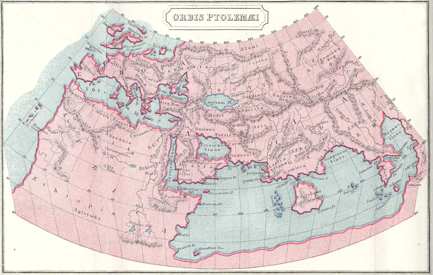
Perhaps this Hellenist map was simply a depiction of their reach or own domain. When you are a child and look at a world map, in the US it is centered on the US, when in China it is centered on China, When in Russia it is centered on Russia etc. etc.
Perhaps this Hellenist map was simply a depiction of their reach or own domain. When you are a child and look at a world map, in the US it is centered on the US, when in China it is centered on China, When in Russia it is centered on Russia etc. etc.
Ptolemy was Greek. Greece is shown at upper left, the map is not centered on it. The map is a map of the entire world.
Harte
Harte
originally posted by: Emma3
a reply to: Hanslune
Exactly. It was probably a Portuguese artifact that found its way to Brazil, somehow. Sometimes people seem to forget the most obvious explanations.
Piri Reis wrote on the map where the source maps came from. He mentioned capturing maps from Spanish and Portuguese ships.
new topics
-
America's Greatest Ally
General Chit Chat: 31 minutes ago -
President BIDEN's FBI Raided Donald Trump's Florida Home for OBAMA-NORTH KOREA Documents.
Political Conspiracies: 5 hours ago -
Maestro Benedetto
Literature: 7 hours ago -
Is AI Better Than the Hollywood Elite?
Movies: 7 hours ago -
Las Vegas UFO Spotting Teen Traumatized by Demon Creature in Backyard
Aliens and UFOs: 10 hours ago -
2024 Pigeon Forge Rod Run - On the Strip (Video made for you)
Automotive Discussion: 11 hours ago -
Gaza Terrorists Attack US Humanitarian Pier During Construction
Middle East Issues: 11 hours ago
top topics
-
President BIDEN's FBI Raided Donald Trump's Florida Home for OBAMA-NORTH KOREA Documents.
Political Conspiracies: 5 hours ago, 26 flags -
Krystalnacht on today's most elite Universities?
Social Issues and Civil Unrest: 16 hours ago, 9 flags -
Gaza Terrorists Attack US Humanitarian Pier During Construction
Middle East Issues: 11 hours ago, 8 flags -
Supreme Court Oral Arguments 4.25.2024 - Are PRESIDENTS IMMUNE From Later Being Prosecuted.
Above Politics: 16 hours ago, 8 flags -
Weinstein's conviction overturned
Mainstream News: 15 hours ago, 8 flags -
Massachusetts Drag Queen Leads Young Kids in Free Palestine Chant
Social Issues and Civil Unrest: 13 hours ago, 7 flags -
Las Vegas UFO Spotting Teen Traumatized by Demon Creature in Backyard
Aliens and UFOs: 10 hours ago, 6 flags -
Meadows, Giuliani Among 11 Indicted in Arizona in Latest 2020 Election Subversion Case
Mainstream News: 13 hours ago, 5 flags -
2024 Pigeon Forge Rod Run - On the Strip (Video made for you)
Automotive Discussion: 11 hours ago, 4 flags -
Is AI Better Than the Hollywood Elite?
Movies: 7 hours ago, 3 flags
active topics
-
HORRIBLE !! Russian Soldier Drinking Own Urine To Survive In Battle
World War Three • 49 • : Freeborn -
Gaza Terrorists Attack US Humanitarian Pier During Construction
Middle East Issues • 30 • : Asher47 -
Electrical tricks for saving money
Education and Media • 8 • : anned1 -
Is AI Better Than the Hollywood Elite?
Movies • 16 • : 5thHead -
Hate makes for strange bedfellows
US Political Madness • 48 • : Terpene -
America's Greatest Ally
General Chit Chat • 0 • : 19Bones79 -
President BIDEN's FBI Raided Donald Trump's Florida Home for OBAMA-NORTH KOREA Documents.
Political Conspiracies • 17 • : BingoMcGoof -
Supreme Court Oral Arguments 4.25.2024 - Are PRESIDENTS IMMUNE From Later Being Prosecuted.
Above Politics • 90 • : Lumenari -
Las Vegas UFO Spotting Teen Traumatized by Demon Creature in Backyard
Aliens and UFOs • 12 • : KrustyKrab -
SHORT STORY WRITERS CONTEST -- April 2024 -- TIME -- TIME2024
Short Stories • 23 • : DontTreadOnMe