It looks like you're using an Ad Blocker.
Please white-list or disable AboveTopSecret.com in your ad-blocking tool.
Thank you.
Some features of ATS will be disabled while you continue to use an ad-blocker.

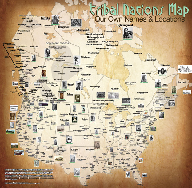
The Map Of Native American Tribes You've Never Seen Before
page: 1share:
The Map Of Native American
Tribes You've Never Seen Before
(npr.org)
I find this fascinating to look at, so many indigenous tribes have been eradicated during colonization or pushed westward. It highlights what a thriving continent the Americas were before Europeans arrived.
(npr.org)
Finding an address on a map can be taken for granted in the age of GPS and smartphones. But centuries of forced relocation, disease and genocide have made it difficult to find where many Native American tribes once lived.
Aaron Carapella, a self-taught mapmaker in Warner, Okla., has pinpointed the locations and original names of hundreds of American Indian nations before their first contact with Europeans.
As a teenager, Carapella says he could never get his hands on a continental U.S. map like this, depicting more than 600 tribes — many now forgotten and lost to history. Now, the 34-year-old designs and sells maps as large as 3 by 4 feet with the names of tribes hovering over land they once occupied.
I find this fascinating to look at, so many indigenous tribes have been eradicated during colonization or pushed westward. It highlights what a thriving continent the Americas were before Europeans arrived.
I find this fascinating, in that, I was trying to determine which races came over the land and/or ice/snow bridge in ancient times. To me some tribes
appear Asian, while others Indian, European and Mongolian through the .pdf and enlargment feature.
www.npr.org...
www.npr.org...
a reply to: Blackmarketeer
I like that guy. What he should do now is superimpose all of the information over a map of North America without the state/province boundary lines. Take a map that shows topography only and plop down the various tribes on that. Then state what each tribe, in their original name, was known for.....what their skill set was.....farming, basket making, hunting game, etc.....
It would be interesting to see with a birds-eye-view the correlation of those skill sets along with their locations. If Mr. Carapella did that, people would see how how the Native's worked with their natural surroundings. Then, if the information is available somewhere, take it all back in 100 year increments and make a new map to reflect each time period. The changes in populations, or lack thereof, would be interesting to see.
If anyone can do this sort of thing, I think he can.
Good find OP, thanks for sharing.
"This isn't really a protest," he explains. "But it's a way to convey the truth in a different way."
I like that guy. What he should do now is superimpose all of the information over a map of North America without the state/province boundary lines. Take a map that shows topography only and plop down the various tribes on that. Then state what each tribe, in their original name, was known for.....what their skill set was.....farming, basket making, hunting game, etc.....
It would be interesting to see with a birds-eye-view the correlation of those skill sets along with their locations. If Mr. Carapella did that, people would see how how the Native's worked with their natural surroundings. Then, if the information is available somewhere, take it all back in 100 year increments and make a new map to reflect each time period. The changes in populations, or lack thereof, would be interesting to see.
If anyone can do this sort of thing, I think he can.
Good find OP, thanks for sharing.
originally posted by: InTheLight
I find this fascinating, in that, I was trying to determine which races came over the land and/or ice/snow bridge in ancient times. To me some tribes appear Asian, while others Indian, European and Mongolian through the .pdf and enlargment feature.
www.npr.org...
It's interesting that the original settlers seemed to have come across the Pacific from various areas, while the white man settled in from Europe via the Atlantic. We know why our forefathers wanted to re-settle, but what drove the original settlers over here?
edit on 26-6-2014 by Taupin
Desciple because: (no reason given)
You might like this www.soundchristian.com... There is a vid by the author as well. Near the end of the talk he brings up some very good
evidence that some of the NA tribes did come from the eastern parts of Europe .We some times thing that or not consider that the oceans may have been
quite different then today and man could have been well equipped and capable of making the journey .Our history text books suck and certain facts of
the past are not in them . a reply to: InTheLight
I didn't see the Birsimis, Algonquin or Mohawk represented on that map. WIll look some more though. It was quite the undertaking on his part and is
quite interesting. I hope he will revise and upgrade it to reflect any additional info he receives. Thanks, OP. Nice find.
a reply to: Taupin Desciple
A recent study has indicated that some members of ancient man lingered in Beringia (the land bridge to Asia) for as much as 10,000 years before completely crossing into the Americas, which goes a long way to explaining the diversity of N. Americans.
On Way to New World, First Americans Made a 10,000-Year Pit Stop
The first human settlers of the New World may have spent ten millennia on the landmass that linked Siberia and Alaska.
Sediment cores from Alaska and the Bering Sea support genetic evidence that the first human settlers of the New World spent thousands of years inhabiting Beringia, the region that included the land bridge between Siberia and Alaska, scientists say.
a reply to: the2ofusr1
(I keep forgetting the name of the show, but it was on Newsworld Sunday night) during its exposé of the firing of government scientists that they showed how the work of one scientist who was proving European ties and origins in the far Arctic was stopped and she was fired, thus ending her research and her livelihood. So unless Europeans pick up the challenge and financing , as Harper certainly won't, we can only wait for proof.
(I keep forgetting the name of the show, but it was on Newsworld Sunday night) during its exposé of the firing of government scientists that they showed how the work of one scientist who was proving European ties and origins in the far Arctic was stopped and she was fired, thus ending her research and her livelihood. So unless Europeans pick up the challenge and financing , as Harper certainly won't, we can only wait for proof.
originally posted by: Taupin Desciple
a reply to: Blackmarketeer
"This isn't really a protest," he explains. "But it's a way to convey the truth in a different way."
I like that guy. What he should do now is superimpose all of the information over a map of North America without the state/province boundary lines. Take a map that shows topography only and plop down the various tribes on that. Then state what each tribe, in their original name, was known for.....what their skill set was.....farming, basket making, hunting game, etc.....
It would be interesting to see with a birds-eye-view the correlation of those skill sets along with their locations. If Mr. Carapella did that, people would see how how the Native's worked with their natural surroundings. Then, if the information is available somewhere, take it all back in 100 year increments and make a new map to reflect each time period. The changes in populations, or lack thereof, would be interesting to see.
If anyone can do this sort of thing, I think he can.
Good find OP, thanks for sharing.
Here's the first part:
www.ushistory.org...
a reply to: the2ofusr1
It goes back and forth, the problem still being there have been very few samples taken to determine exactly the where, when and how people came to the Americas.
"Great Surprise"—Native Americans Have West Eurasian Origins
Not too long ago I read a good research paper on a "Eurasian supergroup," comprised of mixed European and Asians that then flowed into Beringia. The "European" ancestry thus flowed across Beringia and not via an Atlantic crossing. The term if I recall was "West Eurasian", and was differentiated from the more traditionally thought "East Asian" as the origin group for Native Americans.
It goes back and forth, the problem still being there have been very few samples taken to determine exactly the where, when and how people came to the Americas.
"Great Surprise"—Native Americans Have West Eurasian Origins
Nearly one-third of Native American genes come from west Eurasian people linked to the Middle East and Europe, rather than entirely from East Asians as previously thought, according to a newly sequenced genome.
Not too long ago I read a good research paper on a "Eurasian supergroup," comprised of mixed European and Asians that then flowed into Beringia. The "European" ancestry thus flowed across Beringia and not via an Atlantic crossing. The term if I recall was "West Eurasian", and was differentiated from the more traditionally thought "East Asian" as the origin group for Native Americans.
Yea , I have a vague remembrance of her and what she was working on .The Harper's Govt . has done much in the way of silencing research and locking
up some of the archives .Hopefully we can get the next Govt. to undo some of what he has done .I noticed the the Lakes project was reinstated to a
certain level by the Ont. Govt . One can hope . a reply to: aboutface
originally posted by: the2ofusr1
the oceans may have been quite different then today and man could have been well equipped and capable of making the journey.
This is true. That's partly evidenced in the NG link that Blackmarketeer supplied. I remember looking at maps when I was kid showing how land masses were different thousands of years ago and how they slowly formed all the land masses that we have now. If I'm not mistaken, there was a point in time when all the continents were pretty much the same land land mass. I think the movements were caused by tectonics, but I'm not sure anymore.
www.nsf.gov...
Tim Osterholm looks at the different inquires into the subject but he focuses more on names derived from the table of nations in Genesis and then
finds who may have been their ancestors with common names .He finds mention of red skinned peoples with names that are close to some of the North
American tribe names .I guess the debate is still ongoing and we may never have a definitive answer in our life time . a reply to:
Blackmarketeer
Well even considering all of the ice mass on the continents it's not hard to imagine that the sea level could be 300 , 400 feet lower .along with
plate tectonics doing their thing and a possible warmer ocean ,it's really hard to say if you would get the big swells we have today in the North
Atlantic . a reply to: Taupin Desciple
originally posted by: the2ofusr1
Tim Osterholm looks at the different inquires into the subject but he focuses more on names derived from the table of nations in Genesis and then finds who may have been their ancestors with common names .He finds mention of red skinned peoples with names that are close to some of the North American tribe names .I guess the debate is still ongoing and we may never have a definitive answer in our life time . a reply to: Blackmarketeer
Yeah, but it's still fun to look into from time to time. The original premise here I think was to look at how the European settlers did more than just take land from people. They took their identities away as well. This is why I suggested taking the boundaries out of the map because the natives didn't have boundaries like that. I don't think they saw things that way. To get a better understanding of people it helps to see things the way they do, and this is one way of doing that.
It's been fun but I gotta jet.............
a reply to: Taupin Desciple
Taking out the imaginary state boundaries would be a great idea, showing geographical features would illuminate how some native populations settled as they did. Aaron Carapella if you're reading this please take it under consideration for v2.0!
Taking out the imaginary state boundaries would be a great idea, showing geographical features would illuminate how some native populations settled as they did. Aaron Carapella if you're reading this please take it under consideration for v2.0!
PS: to view the full map click the PDF links buried in the caption under the images; I'll repost the links here for convenience;
Full map (North America)(PDF)
Full map (Mexico)(PDF)
Full map (North America)(PDF)
Full map (Mexico)(PDF)
originally posted by: ParanoidAmerican
a reply to: InTheLight
Definitely if you look especially east vs west.....interesting
As well as North and South...north more mongolian (who may have already been hardened to life in cold climates) ...south more south american indian.
new topics
-
Putin, Russia and the Great Architects of the Universe
ATS Skunk Works: 1 hours ago -
A Warning to America: 25 Ways the US is Being Destroyed
New World Order: 5 hours ago -
President BIDEN's FBI Raided Donald Trump's Florida Home for OBAMA-NORTH KOREA Documents.
Political Conspiracies: 11 hours ago
top topics
-
President BIDEN's FBI Raided Donald Trump's Florida Home for OBAMA-NORTH KOREA Documents.
Political Conspiracies: 11 hours ago, 28 flags -
A Warning to America: 25 Ways the US is Being Destroyed
New World Order: 5 hours ago, 11 flags -
Las Vegas UFO Spotting Teen Traumatized by Demon Creature in Backyard
Aliens and UFOs: 16 hours ago, 7 flags -
2024 Pigeon Forge Rod Run - On the Strip (Video made for you)
Automotive Discussion: 17 hours ago, 4 flags -
Is AI Better Than the Hollywood Elite?
Movies: 13 hours ago, 3 flags -
Maestro Benedetto
Literature: 13 hours ago, 1 flags -
Putin, Russia and the Great Architects of the Universe
ATS Skunk Works: 1 hours ago, 1 flags
active topics
-
Weinstein's conviction overturned
Mainstream News • 25 • : brodby -
University of Texas Instantly Shuts Down Anti Israel Protests
Education and Media • 270 • : Xtrozero -
Gaza Terrorists Attack US Humanitarian Pier During Construction
Middle East Issues • 38 • : brodby -
ChatGPT Beatles songs about covid and masks
Science & Technology • 24 • : iaylyan -
The Acronym Game .. Pt.3
General Chit Chat • 7754 • : bally001 -
Nearly 70% Of Americans Want Talks To End War In Ukraine
Political Issues • 96 • : andy06shake -
Rupert Murdoch engaged at 92
People • 8 • : brodby -
"We're All Hamas" Heard at Columbia University Protests
Social Issues and Civil Unrest • 287 • : FlyersFan -
Skinwalker Ranch and the Mystery 1.6GHz Signal
Aliens and UFOs • 144 • : brodby -
A Warning to America: 25 Ways the US is Being Destroyed
New World Order • 11 • : brodby